
Atlantic Hurricane Outlook – July 29, 2025: Active Waves, Quiet Forecast
Several tropical waves are moving across the Atlantic, but none show signs of imminent development. Warm waters persist, and August may bring change.
*Those who like data, continue reading. Those it prefer the quick version, jump to the TL;DR here.
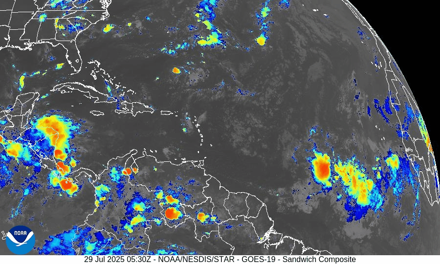
Though the Atlantic basin remains free of tropical cyclones, several tropical waves are shifting across the ocean—each monitored for organization. Conditions remain broadly unfavorable for development, but the warm ocean and evolving atmospheric patterns suggest potential change in the weeks ahead.
Atlantic Basin: No Cyclones, But Several Waves in Motion
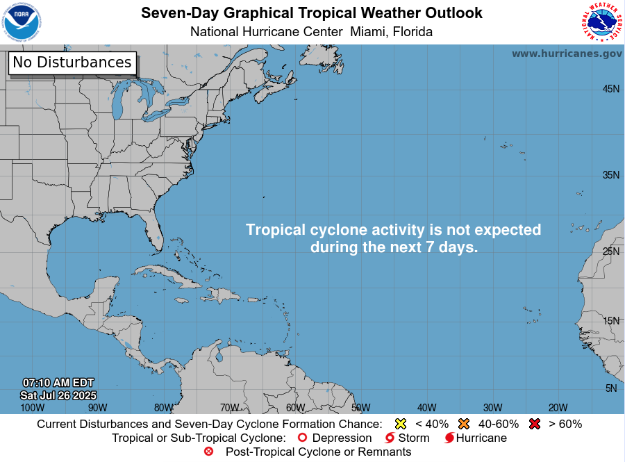
According to the latest Tropical Weather Outlook, the National Hurricane Center does not expect any tropical cyclone formation during the next seven days. However, recent Tropical Weather Discussion reveals:
A tropical wave near 19°W (south of 19°N), moving westward at about 10 kt, with scattered convection between 10°N–13°N and east of 23°W.
Another wave near 38°W, south of 18°N, moving slowly (~5 kt), associated with a 1012 mb low. A scatterometer pass noted fresh to strong winds within 120 nm and scattered convection between 5°N–12°N.
None of these features currently exhibit a closed circulation or organization, but their movement into warmer waters bears monitoring.
Gulf of Mexico & Caribbean: Calm Signals, Minimal Development Risk
No disturbances are being tracked in the Gulf at this time.
Surface analyses and satellite imagery show mostly typical trade-wind patterns and minor convection near Central America and the Windward Passage.
A dominant high-pressure ridge maintains light to moderate winds and minimal seas across most of the region.
Environmental Snapshot: Barriers Remain, Fuel Accumulating
Sea surface temperatures across the Gulf of Mexico and western Caribbean are well above average, delivering ample heat energy for potential development in early August.
The Saharan Air Layer (SAL) continues to suppress convection in the eastern Atlantic. Convection in tropical waves remains shallow and short-lived.
Upper-level wind shear remains moderate to high, especially over the central MDR, limiting vertical storm organization.
SST data courtesy of Windy.com
Florida Forecast: Late-July Heat & Afternoon Storms
Highs across central and south Florida: Near 90–92 °F under humid conditions.
Rain chance: 40–50% with scattered afternoon showers and thunderstorms fueled by sea-breezes and daytime heating.
Wind conditions: Light and variable inland, becoming east-southeasterly near the coast.
No tropical impacts are anticipated over the next 24 hours.
Rain forecast visualization courtesy of Windy.com
Prep Tip of the Day: Keep Monitoring Those Waves
Even when storms don’t form, their precursors still matter:
Review evacuation zones and routes now—not during an emergency.
Check the status of local email lists or alert systems for tropical watches.
Confirm your household has working weather radios and updated contact lists.
Looking Ahead: August May Bring Increased Activity
While development is unlikely in the next 5–7 days, the combination of:
Warm ocean temperatures,
Decreasing wind shear projections, and
Multiple tropical waves entering the MDR
suggests the system is slowly shifting toward a more favorable environment as August begins.
TL;DR
Flood‑ready outlook for July 29, 2025
No tropical cyclones in the basin; no development expected this week.
Two tropical waves showing scattered convection—watching for mid‑Atlantic changes.
Warm Gulf and Caribbean waters offer fuel if shear and dry air ease up.
Florida sees typical summer weather—heat and scattered afternoon storms.
Prep recommendation: finalize hurricane plans, stay informed, remain ready.
For full updates, continue visiting Cat5Prep.com daily.
Atlantic Hurricane Outlook – July 28, 2025: Waves Active, Tropics Stable for Now
Tropical waves are stirring across the Atlantic, but no development is expected over the next 7 days. Warm waters and weakening wind shear suggest conditions could shift heading into August.

*Those who like data, continue reading. Those it prefer the quick version, jump to the TL;DR here.
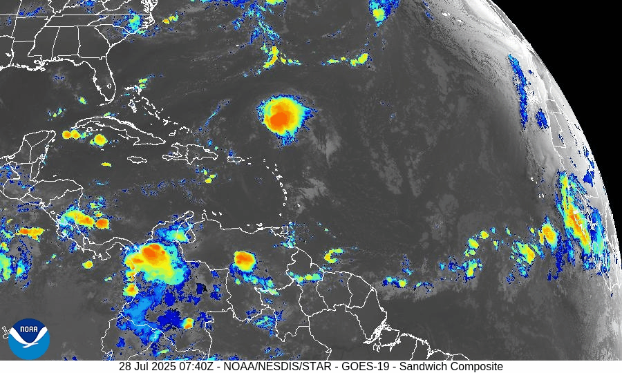
As the final days of July unfold, the Atlantic basin remains active with several tropical waves but no immediate threats. While sea surface temperatures and atmospheric moisture continue to support development, upper-level wind shear and dry air are keeping conditions broadly stable—though this pattern may shift as we enter August.
Atlantic Basin: Multiple Waves, No Cyclones (Yet)
As of 8:00 AM EDT from the National Hurricane Center:
No active tropical cyclones
Two tropical waves are under watch:
Tropical Wave 1: Located near 40°W, moving westward at 10–15 kt with scattered convection. Still disorganized but under observation.
Tropical Wave 2: Recently emerged off Africa near 23°W, with convection along its southern flank. It’s embedded in a moist environment and will be monitored for future development.
No development expected over the next 7 days, but long-range models suggest increasing favorability for late next week.
Gulf of Mexico: Moisture Returns, But No Development
A weak surface trough lingers in the Bay of Campeche, producing isolated showers and thunderstorms.
No signs of tropical development at this time.
Expect scattered showers and storms across the eastern and central Gulf through Tuesday, driven by daytime heating and lingering mid-level moisture.
Caribbean Sea: Typical Summer Conditions
Fresh to strong trades continue in the central and southwest Caribbean, particularly off the coasts of Colombia and Venezuela.
Some isolated thunderstorms are active near Panama and the Windward Passage.
A tropical wave moving through the eastern Caribbean is enhancing convection, but remains disorganized.
Atlantic Main Development Region (MDR): Slowly Activating
Sea surface temperatures (SSTs):
MDR: 28–29°C (82–84°F), well above climatological norms.
Gulf and Caribbean: 30–31°C (86–88°F), fuel-ready.
Saharan Air Layer (SAL): Dry air continues to suppress convection over much of the MDR, but signs show it is beginning to weaken, allowing thunderstorm clusters to persist longer.
Wind shear: Still present in the central Atlantic, but trending downward.
SST data courtesy of Windy.com
Florida Outlook: Typical Late-July Storms
North Florida: Partly sunny with highs in the upper 80s. Afternoon storms possible.
Central Florida: Hot and humid (highs ~91°F) with scattered PM thunderstorms likely.
South Florida: Muggy with highs in the upper 80s. Thunderstorms expected after 2 PM.
Radar imagery courtesy of Windy.com
Prep Tip of the Day: Inventory Your Storm Gear
Now is a good time to audit your hurricane kit:
Check expiration dates on food, batteries, and meds.
Reassess your generator fuel supply and run a quick test.
Confirm family members know where the supplies are stored.
Looking Ahead: Eyes on Early August
While July is ending quietly, model ensembles hint at better organization potential in the MDR during the first 7–10 days of August.
A Kelvin wave (a burst of upper-level moisture and instability) may traverse the Atlantic next week, setting the stage for more robust wave activity.
TL;DR – July 28, 2025 Hurricane Snapshot
No active storms or tropical depressions
Two tropical waves being watched, neither near development
Gulf and Caribbean: Moist, unsettled, but not organized
MDR: Warm and slowly transitioning to a more favorable pattern
Florida: Classic summer pattern — hot, humid, and stormy afternoons
Outlook: Low risk this week, but August may bring change
Stay informed at Cat5Prep.com, and use this calm to finalize your preparations.

Atlantic Hurricane Outlook – July 27, 2025: Calm Conditions Continue Despite Active Waves
The tropics stay quiet on July 27, 2025, but tropical waves in the deep Atlantic are being closely monitored. No development is expected in the next 7 days, but changes could come as we approach August.

*Those who like data, continue reading. Those it prefer the quick version, jump to the TL;DR here.
The Atlantic basin remains free of named storms this morning, with no tropical cyclone formation expected over the next seven days. However, meteorologists are closely monitoring several tropical waves in the deep eastern Atlantic that could signal a developing pattern as we head into August.
Atlantic Basin: Quiet—but Watchful
No active tropical cyclones in the Atlantic basin.
The National Hurricane Center (NHC) reports that no tropical development is expected over the next 7 days.
Tropical waves in the eastern and central Atlantic continue to be monitored for organization.
Gulf of Mexico and Caribbean: No Significant Activity
No low-pressure disturbances currently under watch.
Conditions in the Gulf remain stable, with typical afternoon thunderstorms but no signs of tropical development.
Lower Caribbean waters remain under fresh easterly trade winds, with rather isolated convection near Central America.
Tropical Waves: Deep Atlantic Features to Monitor
According to the NHC’s Tropical Weather Discussion:
A tropical wave near 27°W (south of 17°N) is moving west at ~10 kt, with scattered moderate convection noted between 5°N and 9°N.
A stronger wave near 54°W (south of 22°N) is moving west at 15–20 kt, with scattered convection between 5°N–23°N.
An area of low pressure embedded in the monsoon trough near 8°N44°W is also aiding scattered convection but remains disorganized.
None of these systems currently have the structure required for classification, but they inhabit regions where sea surface temperatures and wind shear may soon become more conducive to development.
Environmental Conditions Snapshot
The Saharan Air Layer (SAL) remains strong across the eastern Atlantic, suppressing mid-level moisture and convection.
Wind shear in the central Atlantic remains moderate to high, limiting tropical organization—though forecasts suggest a gradual reduction heading into early August.
Sea surface temperatures across the Main Development Region (MDR) remain above average, providing energy should conditions improve later this month.
Dust & SAL data from Windy.com
Florida Forecast
Highs around 90 °F with coastal humidity making it feel hotter.
Rain Chance: 40–50% for scattered afternoon thunderstorms driven by sea breeze convergence.
Winds: Light and variable, shifting to southeasterly in the afternoon.
No tropical impacts expected today.
Rain forecast visualization courtesy of Windy.com
Prep Tip of the Day: Check Your Weather Apps and Alerts
While the tropics are quiet, confirming your local alert settings and weather tool readiness can make all the difference:
Enable push notifications for National Hurricane Center advisories.
Confirm alert registration with your county emergency system.
Test weather apps and bookmarks on all household phones and devices.
Looking Ahead: August May Bring Change
Though today’s conditions remain tranquil, the presence of several tropical waves moving into warmer Atlantic waters—combined with weakening Saharan dust and decreasing wind shear—suggest a gradual shift toward a more active setup. Historically, the first week of August often kicks off heightened tropical activity.
Stay alert. Stay ready. Daily Atlantic updates from Cat5Prep.com.
TL;DR
Atlantic Hurricane Forecast for July 27, 2025
No tropical storms are expected this week — the Atlantic remains quiet.
Three tropical waves are being monitored across the basin. None are showing strong signs of development yet.
Sea surface temperatures are hot and rising — especially in the Gulf and Caribbean — setting the stage for activity in August.
Wind shear and dry air (Saharan dust) continue to limit development for now.
Florida and the Gulf Coast: Typical summer weather—hot, humid, and scattered afternoon storms.
Prep Tip: Now is the time to stock up on essentials and finalize your hurricane communication plan.
No immediate threats, but stay alert. The quiet won’t last forever.
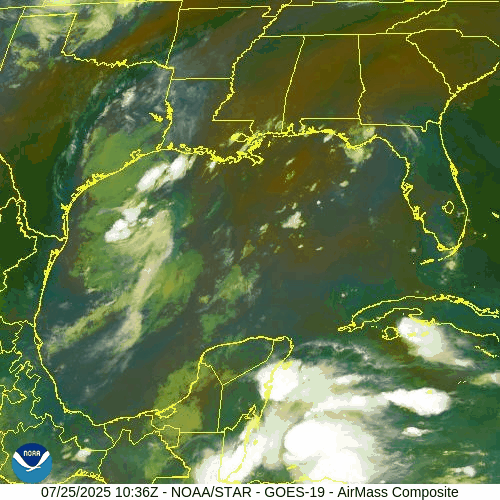
Atlantic Hurricane Outlook – July 26, 2025: Gulf Moisture Lingers, Deep Tropics Show Early Signs of Change
Moisture continues to stream into Texas and Louisiana from the Gulf, while tropical waves in the deep Atlantic hint at a pattern shift. No named storms yet, but conditions are slowly becoming more favorable.
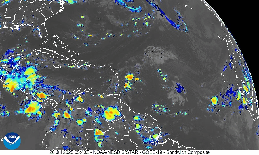
The Atlantic basin remains free of any named tropical cyclones, but not without activity. A persistent disturbance in the western Gulf of Mexico continues to funnel tropical moisture into parts of Texas and Louisiana, while multiple tropical waves in the deep Atlantic are stirring early signals of future development.
This mid-season quiet is not unusual—but subtle shifts are beginning to show across the basin. As we approach August, conditions will slowly lean more favorable for storm formation.
Gulf of Mexico: Persistent Moisture, Low Development Potential
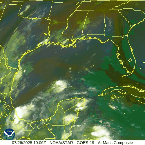
NOAA/NESDIS/STAR – GOES-19 Air Mass Composite – July 26, 2025 (Gulf)
A weak surface trough remains in the western Gulf of Mexico, associated with disorganized showers and thunderstorms.
Current Status: No surface circulation, limited upper-level support
Rain Impacts: Coastal Texas and Louisiana remain under intermittent showers and thunderstorms through the weekend
Development Chance: Still near 0%—but the system is being monitored for changes
Elsewhere in the Gulf, conditions remain stable, with light to moderate winds and seas of 2–5 ft across most zones.
Tropical Waves: Marching Westward, Holding Potential
Several tropical waves remain active in the central and eastern Atlantic:
Wave near 40°W: Moving west at ~10–15 kt, producing scattered convection. Still disorganized but in warm waters with marginal wind shear.
Wave near 23°W (off Africa): Embedded in the monsoon trough. Convection flaring along southern flank; too early for development but bears watching.
None of these waves currently show signs of imminent organization, but they are tracking into warmer waters and a slowly improving environment.
NOAA/NESDIS/STAR – GOES-19 Sandwich Composite – July 26, 2025 (Tropical Atlantic)
Sea Surface Temperatures: Primed for August
Gulf of Mexico: 86–88°F across most areas
Caribbean Sea: Upper 80s°F, especially in the western basin
Main Development Region (MDR): 82–84°F, 1–2°F above average
The Atlantic remains historically warm, a key ingredient for fueling tropical cyclones as we near peak season.
SST data courtesy of Windy.com
Atmospheric Conditions: Gradual Shift Unfolding
Wind Shear: Still moderate in the central Atlantic, but weakening trends are forecast
Moisture: Mid-level moisture increasing, especially south of 20°N
Saharan Air Layer (SAL): Still active, but thinning between 35°W–50°W
These slow, quiet changes signal a transition to a more favorable setup in early August.
Dust & SAL data from Windy.com
Florida Forecast
Today’s Weather:
High: 90°F
Conditions: Partly sunny, humid
Storm Risk: Scattered inland thunderstorms after 2 PM
Winds: Light and variable
Prep Reminder: Monitor drainage around your property during afternoon storms
Rain forecast data courtesy of Windy.com
Prep Tip of the Day: Check Local Shelters & Pet Plans
Locate your nearest hurricane shelter—especially if you're new to your area
Identify which shelters allow pets (many do, but require pre-registration)
Add leash, crate, and vaccination documents to your go-kit
Looking Ahead: Window of Quiet Before August Heats Up
Although no named systems are expected in the next 5–7 days, the setup across the basin is gradually shifting. The Gulf disturbance remains weak, but new tropical waves are aligning with less hostile conditions.
This is the time to finalize your hurricane supplies, prep your property, and stay informed.
Check back tomorrow for another update from Cat5Prep.com.

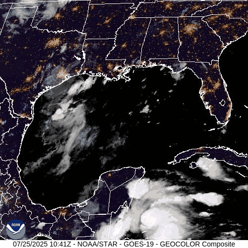
Atlantic Hurricane Outlook – July 25, 2025: Gulf Disturbance Monitored, Basin Remains Broadly Quiet
Stay updated on the Atlantic hurricane season: July 25, 2025. A weak Gulf disturbance brings rain to Texas & Louisiana, while the broader Atlantic remains quiet with no immediate threats. Prepare now for August!

As we close out the final week of July, the Atlantic basin remains broadly quiet. The only area of interest remains a weak disturbance in the western Gulf of Mexico, which continues to produce showers but shows little sign of organizing. Elsewhere, several tropical waves are making their westward march across the Atlantic, but no significant development is expected in the short term.
Gulf of Mexico: Weak Trough Brings Rain, Low Development Risk
A surface trough remains draped across the western Gulf of Mexico, generating scattered showers and isolated thunderstorms—particularly offshore of Texas and Louisiana.
The disturbance remains disorganized, with no closed low-level circulation.
Wind shear and surrounding dry air continue to limit development potential.
The National Hurricane Center (NHC) gives this system a low (10%) chance of development over the next 7 days.
However, heavy downpours and localized flooding remain possible across parts of coastal Texas and southwestern Louisiana today.
This weak trough is expected to gradually dissipate as it moves slowly westward.
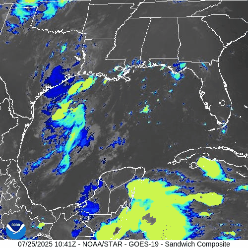
Atlantic Basin: Multiple Waves, No Immediate Threats
The broader Atlantic remains seasonally active with several tropical waves but no current threats:
Tropical wave near 50°W: Moving westward with scattered convection; not showing signs of organization.
New wave near 23°W, just off the coast of Africa: Tracking westward along the monsoon trough with convection near its southern flank.
A weak low embedded in the monsoon trough near 08N44W is helping spark convection but lacks any closed circulation.
None of these features show signs of imminent development, though they will be monitored closely in the coming days.

NOAA/NESDIS/STAR – GOES-19 Air Mass Composite – July 25, 2025
Sea Surface Temperatures & Atmospheric Conditions
Sea Surface Temperatures (SSTs) across the Gulf of Mexico and Main Development Region (MDR) remain well above average, supplying ample fuel for tropical development later this season.
Wind Shear remains moderate in the central and western Atlantic, limiting near-term organization.
The Saharan Air Layer (SAL) continues to suppress convection across much of the eastern Atlantic, especially north of the MDR.
Dust & SAL data from Windy.com
Florida Forecast: Typical Summer Pattern
Today’s outlook for Central Florida includes:
Highs in the low 90s°F (32–34°C)
Humidity: High, with heat indices nearing the upper 90s
Rain Chances: Scattered afternoon thunderstorms, driven by sea breeze and daytime heating
Winds: Light and variable, shifting southeast in the afternoon
No tropical impacts are expected for Florida at this time.
Radar imagery courtesy of Windy.com
Prep Tip of the Day: Review Your Evacuation Routes
Use this quiet period to refresh your storm plan:
Know your local evacuation zones
Map out primary and alternate routes
Keep a printed copy in your emergency kit in case power or cell service goes down
Share your plan with family or household members
Looking Ahead: Tropics Likely to Awaken in August
While the Atlantic basin remains quiet for now, the underlying signals—record SSTs, westward-moving waves, and easing shear—suggest a more favorable environment could emerge as we enter August. Stay alert, stay prepared, and keep checking in for daily updates.

Atlantic Hurricane Outlook – July 24, 2025: Gulf Disturbance Monitored as Tropics Remain Broadly Quiet
A weak disturbance in the Gulf of Mexico brings rain to the Gulf Coast, but tropical development chances remain low. Meanwhile, the broader Atlantic remains quiet.
As we near the close of July, the Atlantic remains largely stable, but the National Hurricane Center is monitoring a weak disturbance in the Gulf of Mexico for any signs of development. While conditions remain broadly unfavorable for rapid formation, subtle shifts in the atmosphere suggest we’re approaching a more active phase of the season.
Atlantic Basin: Broad Stability, But Eyes on the Gulf
As of the 8:00 AM EDT Tropical Weather Outlook, the National Hurricane Center (NHC) is reporting:
No active tropical cyclones
One disturbance in the Gulf of Mexico with low development chances
No tropical cyclone formation expected elsewhere over the next 7 days
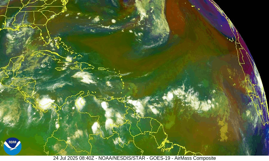
NOAA/NESDIS/STAR – GOES-19 Air Mass Composite – July 24, 2025
Gulf of Mexico: Surface Trough Brings Rain, Low Development Risk
A broad surface trough located over the north-central Gulf of Mexico is generating scattered showers and thunderstorms. While upper-level winds remain hostile to development, the NHC notes this system could persist for several days as it drifts slowly westward.
Formation chance (7 days): Low (near 10%)
Main impacts: Localized heavy rain along portions of the Gulf Coast (especially Louisiana, Mississippi, and Alabama)
Conditions: Disorganized thunderstorm activity, no defined surface circulation
Expect periodic showers and thunderstorms over coastal waters and possible heavy rainfall inland through the weekend.
Rainfall forecast (ECMWF) courtesy of Windy.com
Caribbean Sea: Breezy Trades, Typical Mid-Summer Weather
No disturbances of concern
Fresh easterly trade winds dominate the central and southern basin
Scattered convection near the coasts of Central America (Panama, Nicaragua) due to the East Pacific Monsoon Trough
Seas remain moderate, with wave heights of 4 to 7 feet in open waters.
Wind forecast (ECMWF) courtesy of Windy.com
Wave height forecast (ECMWF Waves) courtesy of Windy.com
Atlantic Tropical Waves: Multiple Waves Marching West
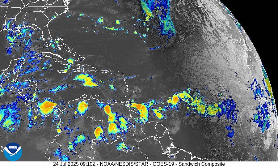
GOES-19 - Sector view: Tropical Atlantic - Sandwich - July 24, 2025
Several tropical waves are present across the Atlantic:
Central Atlantic Wave (~35W): Slowly advancing west with scattered convection, no signs of organization yet.
New Wave Near 23W (Far East Atlantic): Recently introduced by the NHC; embedded within the monsoon trough, showing convective activity near its southern flank.
Low Near 08N44W: Part of the broader monsoon trough; helping to enhance scattered thunderstorms but remains disorganized.
These features will be monitored over the next 7–10 days as they move into warmer waters and potentially more favorable conditions.
850 hPa wind data courtesy of Windy.com
Saharan Air Layer (SAL): Dry Air Suppressing Growth
The Saharan dust plume continues to stretch across the central Atlantic, limiting tropical development by reducing moisture and increasing wind shear. However, long-range forecasts suggest the SAL may begin to thin as we move into August, potentially opening the door for more development.
Saharan Air Layer (SAL) dust data courtesy of Windy.com
Sea Surface Temperatures: Hot and Getting Hotter
Ocean temps across the basin remain above average:
Gulf of Mexico: 30–31°C (86–88°F)
Caribbean Sea: 29–30°C (84–86°F)
Main Development Region (MDR): 28–29°C (82–84°F)
These conditions are supportive of development—but only if wind shear and dry air ease.
Sea surface temperature data courtesy of Windy.com
Florida Forecast
Highs: 89–91°F
Rain Chance: 50–60%, mainly afternoon thunderstorms driven by seabreeze interaction
Winds: Light southeast winds
Hazards: Isolated downpours, brief gusty winds
Rain forecast data courtesy of Windy.com
Prep Tip of the Day: Review Your Local Evacuation Zone
During quiet days, take time to review your local evacuation maps and zones:
Know when you would leave and where you’d go.
Print hard copies in case cell service fails.
Share your plan with family and neighbors.
Find evacuation information from your county emergency management office or state disaster preparedness website.
Looking Ahead: A Turn Toward Activity?
While the current atmosphere is keeping storms at bay, sea temperatures and tropical wave activity suggest a transition toward increased potential in early August. The Gulf disturbance is not expected to develop significantly, but it reminds us that the quiet can shift quickly.
Stay informed and prepared—Cat5Prep.com will continue tracking it all, daily.

Atlantic Hurricane Outlook – July 23, 2025: Gulf Disturbance Brings Rain Risk, Tropics Mostly Stable
A low-pressure system in the north-central Gulf is bringing rain to Florida and the northern coast, but development remains unlikely. Multiple waves in the Atlantic are being monitored.
The Atlantic basin remains quiet overall, but a new area of interest has developed in the north-central Gulf of Mexico, with a low (10%) chance of tropical development. Elsewhere, multiple tropical waves continue their westward journey across the Atlantic, but none show signs of immediate organization.
Gulf of Mexico: Watching a Coastal Disturbance
As of the 8:00 AM EDT update from the National Hurricane Center, a trough of low pressure just offshore the southeastern United States is producing disorganized showers and thunderstorms over the north-central Gulf. The system is forecast to drift west-southwestward over the next day or two into more open waters.
Chance of development remains low (10%) as the system will likely move inland before organizing.
Regardless of development, locally heavy rain is expected along the Florida west coast and the northern Gulf coast through the weekend.
We'll continue to monitor this system closely for any signs of improvement in structure.
Satellite imagery courtesy of Windy.com
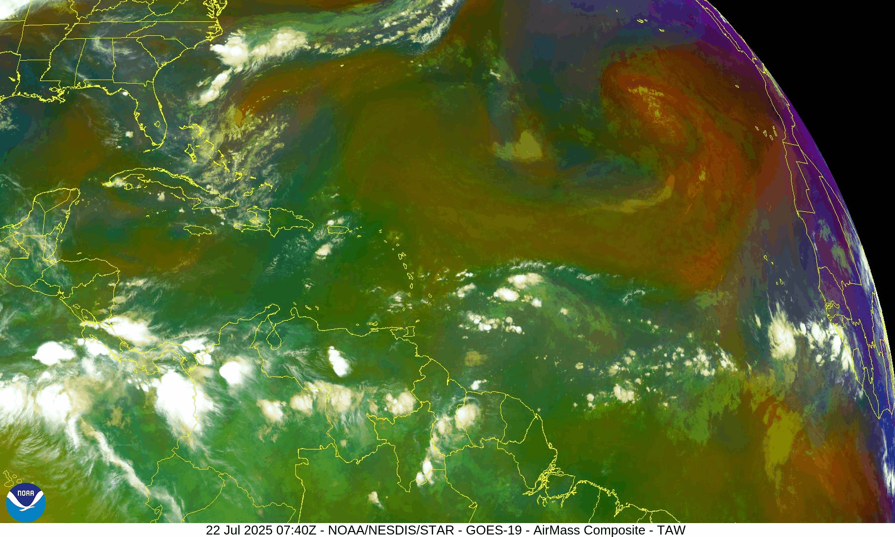
Atlantic Basin: Multiple Waves Being Tracked
There are no active tropical cyclones, but several waves are being tracked in the deep tropics:
A tropical wave near 40°W continues to produce scattered convection but remains disorganized.
A new wave near 23°W just off the African coast was introduced in this morning’s outlook. It’s producing moderate convection along its southern extent.
A low-pressure feature near 08N44W, embedded within the monsoon trough, is also aiding convection but not expected to develop in the near term.
These features will be watched for signs of improved structure as they move westward.

NOAA/NESDIS/STAR – GOES-19 Air Mass Composite – July 23, 2025
Caribbean & Western Atlantic: Typical July Conditions
Scattered thunderstorms continue near eastern Cuba, Hispaniola, and the southwest Caribbean.
Trade winds remain moderate to fresh across much of the basin.
Seas range from 4 to 8 feet, highest in the south-central Caribbean.
The Saharan Air Layer remains weak to moderate, allowing more moisture into the mid-tropics.
Florida Forecast
Highs: 89–92°F (32–33°C)
Humidity: High, with heat index values over 100°F possible
Rain chances: Elevated this afternoon due to outer moisture from the Gulf disturbance
Winds: Light east-southeast, higher near thunderstorms
Rainfall forecast (ECMWF) courtesy of Windy.com
Prep Tip of the Day: Don’t Let “Low Chances” Lull You
Even disturbances with low formation chances can bring:
Flash flooding
Power outages
Road hazards
Use today to test emergency alerts, stock up on essentials, and make sure you’re signed up with your county’s emergency management system.
Looking Ahead
While July continues to show gradual tropical stirring, the big-picture signals—warmer SSTs, decreasing shear, and more active wave patterns—still point toward a ramp-up in early August. Stay ahead of it, and keep checking back for the latest updates.

Atlantic Hurricane Outlook – July 22, 2025: Tropics Stirring, But Development Remains Gradual
Tropical activity is picking up across the Atlantic, with multiple waves being monitored. While no storms are expected yet, conditions are slowly becoming more favorable for development.
The Atlantic basin remains free of named storms this morning, but the deep tropics are showing increased activity. Multiple tropical waves are marching across the basin—some with disorganized convection, others with early signs of circulation. While none are forecast to develop imminently, the atmospheric stage is being set for a more active period as we approach late July.
Atlantic Basin: Several Waves Under Watch
As of the 8:00 AM EDT Tropical Weather Outlook from the National Hurricane Center (NHC):
No active tropical cyclones
Two tropical waves of interest:
Central Atlantic wave near 45°W: Still disorganized, no longer showing on NOAA Seven-Day TWO , moving westward at 10–15 knots. Scattered convection continues, and models suggest a more favorable environment as it approaches the Caribbean later this week.
Chance of development over 7 days: Low (20%)Far Eastern Atlantic wave near 27°W: Recently emerged off Africa. Some associated convection along its southern flank, but no signs of organization yet.
Both systems are embedded in the broader Monsoon Trough, which is supporting shower and thunderstorm development across the deep tropics.
Sea Surface Temperatures: Favorable and Climbing
Ocean waters remain well above average in key areas:
Gulf of Mexico: 86–90°F (30–32°C) across most of the basin
Western Caribbean: Steady warming, ideal for storm fuel
Main Development Region (MDR): 1–2°C above normal across much of the eastern and central Atlantic
These conditions provide a supportive foundation for any systems that organize over the coming weeks.
Sea Surface Temperature data courtesy of Windy.com
Wind Shear and Atmospheric Conditions: Mixed Signals

Wind Shear Courtesy of https://tropic.ssec.wisc.edu/
Wind shear is moderate across much of the Caribbean and central Atlantic, but is beginning to weaken in pockets—especially south of 20°N.
Moisture levels in the mid and lower atmosphere continue to rise, supporting the recent uptick in convection.
Dry air from the Saharan Air Layer (SAL) still lingers across parts of the eastern Atlantic but is beginning to fragment—reducing one of the main inhibitors to development.
Relative Humidity (ECMWF) data courtesy of Windy.com
Saharan Air Layer (Dust) data courtesy of Windy.com
Thunderstorm Activity: Widespread in the Deep Tropics
Clusters of convection are active:
Along the monsoon trough from 10°N to 15°N between 25°W and 50°W
In the western Caribbean, especially south of Jamaica, where upper-level support is creating isolated thunderstorms
Over Central America and the Yucatán Peninsula, where diurnal heat is triggering inland storms
These are not organized tropical systems—but they reflect a broader shift toward a more favorable convective environment.
Thunderstorm forecast (ECMWF) courtesy of Windy.com
Florida Forecast: Hot, Humid, and Stormy
Expect a classic Florida summer day:
North Florida: Highs in the upper 80s to low 90s°F, scattered PM storms
Central Florida: Around 91°F with heat index nearing 102°F; thunderstorms likely between 2–7 PM
South Florida: Mid-to-upper 80s, muggy, with pockets of heavy rainfall inland
Localized flooding is possible in low-lying areas during heavy downpours.
Rainfall forecast (ECMWF) courtesy of Windy.com
Prep Tip of the Day: Recheck Insurance Coverage
Use this quiet window to review your insurance:
Verify your hurricane deductible and coverage limits
Make sure flood insurance is in place—it typically has a 30-day waiting period
Store digital copies of policies in a secure cloud folder
Photograph your home’s exterior and interior for pre-storm documentation
Looking Ahead: No Immediate Threats, But the Tropics Are Heating Up
While no storms are expected in the next 48 hours, the increasing wave activity, warm ocean waters, and weakening SAL suggest the tropics are transitioning into a more active phase. Late July into early August is a known ramp-up period for development.
Stay alert, stay ready, and check back tomorrow for your Cat5Prep.com hurricane update.

Atlantic Hurricane Outlook – July 21, 2025: Tropics Active with Waves, But No Imminent Threats
The Atlantic remains cyclone-free, but several tropical waves are moving across the basin. Conditions are gradually becoming more favorable for development as July progresses.
The tropical Atlantic is becoming increasingly active, with multiple tropical waves progressing westward across the basin. While none are expected to develop in the short term, the setup is a reminder that we are entering a more climatologically favorable period for storm formation.
Satellite imagery courtesy of Windy.com
Atlantic Basin Overview: No Cyclones, But Multiple Waves
As of the 8:00 AM EDT update from the National Hurricane Center:
No active tropical cyclones
No systems with high development potential at this time
Disturbance 1: A tropical wave near 40°W is producing scattered convection, but environmental conditions remain only marginally favorable.
Formation chance (7 days): 20%
Movement: West to west-northwest at 10–15 mph
New Wave Introduced: A second tropical wave near 23°W, just offshore of Africa, is showing scattered moderate convection on its southern flank.
Too early to determine development potential, but it will be watched over the coming days.
Monsoon Trough Low: A weak low embedded along the monsoon trough near 08N44W is sparking convection, but not currently organized.
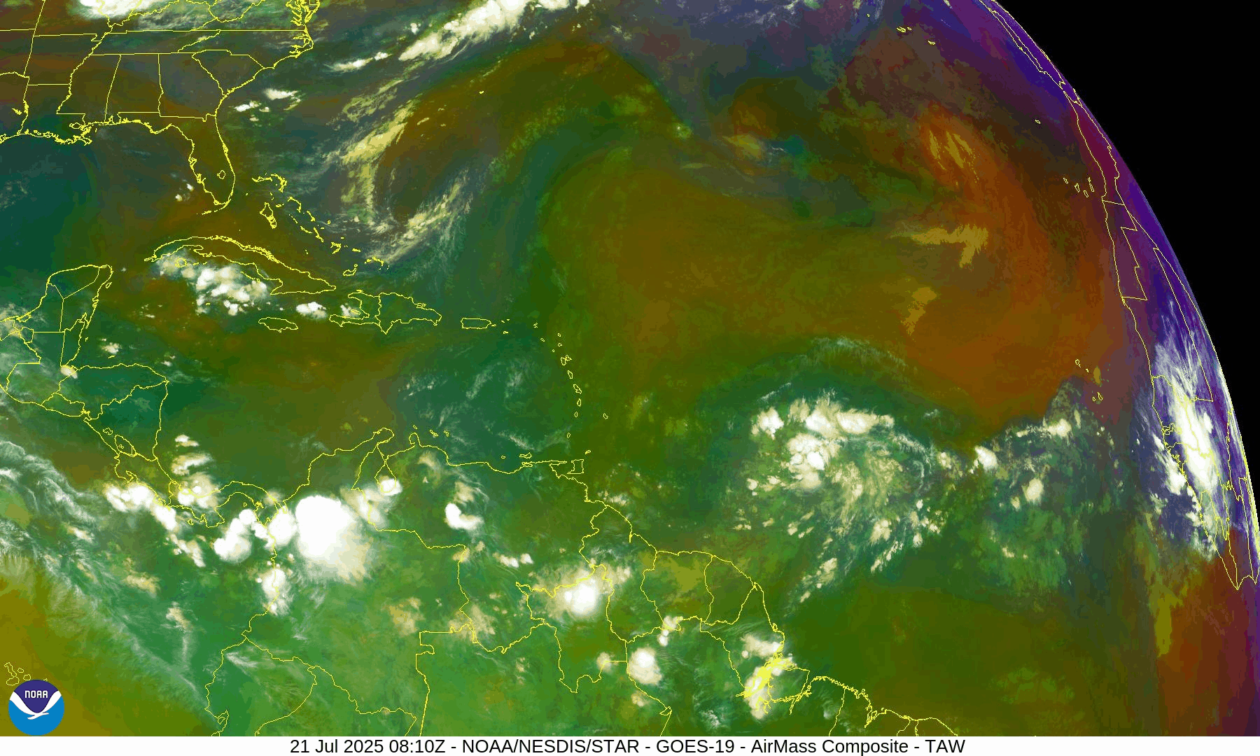
NOAA/NESDIS/STAR – GOES-19 Air Mass Composite – July 21, 2025
Sea Surface Temperatures (SSTs): Still Warm
Gulf of Mexico: 86–88°F – well above average
Western Caribbean: 85–87°F – supportive of development
Main Development Region (MDR): 82–84°F and climbing, with warm anomalies persisting
Warm waters throughout the basin provide the necessary energy for storms should other conditions align.
Sea Surface Temperature data courtesy of Windy.com
Wind Shear and Atmospheric Conditions

Wind Shear Courtesy of https://tropic.ssec.wisc.edu/
Shear remains moderate across much of the central and eastern Atlantic but is expected to weaken later in the week.
Moisture levels continue rising, particularly in the MDR and Caribbean.
Saharan Air Layer (SAL): Still present but beginning to thin slightly, particularly west of 40°W.
These factors collectively suggest improving potential for storm development by late July or early August.
Relative Humidity (ECMWF) data courtesy of Windy.com
Saharan Air Layer (Dust) data courtesy of Windy.com
Gulf of Mexico & Caribbean Outlook
A surface trough remains in the eastern Bay of Campeche, producing scattered thunderstorms.
Light to moderate winds (10–15 kt) dominate much of the Gulf, with seas around 3–5 feet.
Fresh winds (15–20 kt) and higher seas (6–8 ft) continue across parts of the south-central Caribbean.
Expect stronger trades and more convection near the Windward Passage and central Caribbean midweek as a tropical wave enters the region.
Wave height forecast (ECMWF Waves) courtesy of Windy.com
Surface pressure data (ECMWF) courtesy of Windy.com
Florida Forecast
Highs: Upper 80s to low 90s°F
Humidity: High
Rain Chances: Scattered afternoon thunderstorms, driven by sea breezes and instability
Winds: Light and variable, turning southeast near the coast
Hazards: Isolated strong storms possible with gusty winds and localized flooding
Rainfall forecast (ECMWF) courtesy of Windy.com
Prep Tip of the Day: Update Insurance and Inventory
Use this lull to get your disaster documentation in order:
Review your homeowners or renters insurance policy
Document your belongings via photos or video
Store digital backups in the cloud
Know your flood zone and verify your flood insurance coverage
Looking Ahead: Tropics Warming Up
While no tropical cyclone development is expected in the next 7 days, the overall pattern is becoming more favorable. Multiple waves in the deep tropics bear watching, and model guidance hints at potential activity in early August. We'll continue monitoring all waves for signs of organization.
Stay informed, stay prepared, and check back daily for updates from Cat5Prep.com.

Atlantic Hurricane Outlook – July 20, 2025: Tropical Wave Parade Signals a Shifting Pattern
Multiple tropical waves are moving across the Atlantic, including a monitored disturbance near 40°W and a new wave off the African coast. While no tropical cyclones are active, conditions are being closely watched for signs of development.
As we close out the third week of July, the Atlantic remains without named storms—but activity is clearly on the upswing. Multiple tropical waves stretch across the basin, including a disturbance in the central Atlantic, a new wave off Africa, and a low near 08N44W. While none are close to development yet, we are seeing textbook signs of a transitioning pattern that could prime the Atlantic for August’s ramp-up.
Atlantic Basin: Watching Several Waves
As of the 8:00 AM EDT Tropical Weather Outlook and 0600 UTC Surface Analysis:
No active tropical cyclones
One area of interest with low development chances (20%): A tropical wave near 40°W continues to be monitored.
New tropical wave introduced: Near 23°W in the far eastern Atlantic (off Africa), moving westward with convection along its southern flank.
Low pressure near 08N44W embedded in the monsoon trough is helping spark convection.
Disturbance 1, the central Atlantic wave, continues to move westward at 10–15 knots. While still disorganized, it maintains scattered convection and remains under close watch. Other waves in the deep tropics—including the new one off Africa—will be tracked for organization over the coming week.
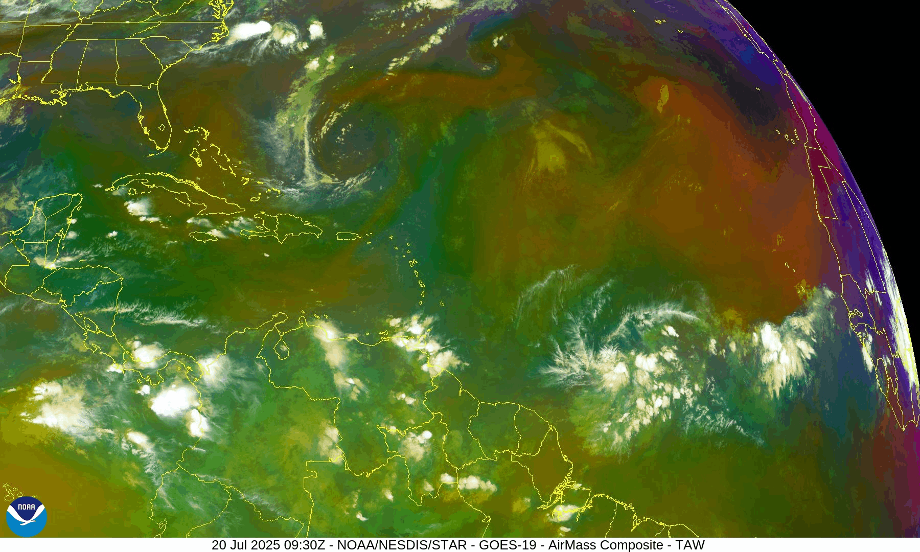
NOAA/NESDIS/STAR – GOES-19 Air Mass Composite – July 20, 2025
Sea Surface Temperatures: Warm and Welcoming
Ocean heat content remains very favorable:
Gulf of Mexico: 86–89°F (30–32°C)
Western Caribbean: Holding steady at 86°F+
Main Development Region (MDR): Near-to-above normal, especially between 30W and 50W
There is no shortage of storm fuel—the atmosphere just needs to catch up.
Sea Surface Temperature data courtesy of Windy.com
Wind Shear & Moisture: A Gradual Shift
Wind shear remains moderate in the central and western Atlantic, but is forecast to slowly ease.
Dry air from the Saharan Air Layer continues to impede vertical development of tropical waves, especially in the MDR.
Moisture is increasing around the Intertropical Convergence Zone and the Caribbean, a key precursor for storm organization.

Wind Shear Courtesy of https://tropic.ssec.wisc.edu/
Relative Humidity (ECMWF) data courtesy of Windy.com
Saharan Air Layer: Still in Control—for Now
The SAL remains widespread across the eastern and central Atlantic, with effects including:
Dry air entrainment disrupting convective growth
Stronger mid-level winds inhibiting vertical cloud development
This suppression is expected to loosen over the next 7–10 days, coinciding with climatological acceleration.
Saharan Air Layer (Dust) data courtesy of Windy.com
Monsoon Trough & Convection: Activity Percolating
A monsoon trough stretches from western Africa to near 46°W and supports scattered convection, particularly around 08N44W.
The new wave near 23°W is accompanied by moderate convection—early signs of organization.
Another tropical wave has now moved inland over Central America and is now being monitored in the East Pacific.
Satellite imagery courtesy of Windy.com
Gulf of Mexico: Typical July Pattern, But Shifts Ahead
A surface trough over the Bay of Campeche is causing showers and thunderstorms in the far southwestern Gulf.
Another weak trough across Florida is sparking isolated thunderstorms off the Gulf coast near Naples.
A weak high near the northeast Gulf continues to dominate.
Looking ahead:
Winds could increase by Thursday across the NE Gulf as broad low pressure moves across the southeastern U.S. and possibly into the northern Gulf.
Widespread showers and thunderstorms expected midweek across the east and north-central Gulf waters.
Surface pressure data (ECMWF) courtesy of Windy.com
Caribbean Sea: Breezy and Stormy in the South-Central Basin
Fresh to strong NE to E winds continue in the south-central Caribbean, with seas of 8–11 ft.
Moderate to fresh trades elsewhere with 4–7 ft seas.
Scattered storms noted near Haiti, eastern Cuba, and Panama’s western coast.
A tropical wave expected midweek will bring enhanced shower and thunderstorm activity across the eastern Caribbean and Windward Passage.
Wave height forecast (ECMWF Waves) courtesy of Windy.com
Florida Forecast: Classic Mid-July Conditions
Expect hot and stormy conditions today:
Highs: Around 93°F (34°C)
Humidity: High, with heat index values near 102°F
Storms: Scattered afternoon and evening thunderstorms—non-tropical but locally strong
Winds: Light and variable
Rainfall forecast (ECMWF) courtesy of Windy.com
Prep Tip of the Day: Start Prepping for August, Not Reacting to It
With the tropics on the edge of activity, now’s the time to get ahead:
Replenish your hurricane kit (water, food, medicine, power banks)
Make sure your contact list includes out-of-area family
Stay signed up for emergency alerts in your area
Looking Ahead: Calm Now, But the Tropics Are Flexing
Though no storms are imminent, tropical waves are increasingly active, sea temperatures are peaking, and dry air is slowly loosening its grip.
This is the time to watch, prepare, and not underestimate how quickly conditions can change. Stay with Cat5Prep.com for daily, real-time updates you can trust.
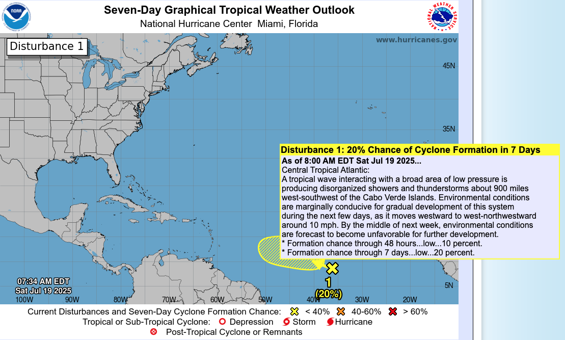
Atlantic Hurricane Outlook – July 19, 2025: Disturbance in the Deep Tropics Eyes Development
A tropical wave southwest of the Cabo Verde Islands shows a low chance of development as it moves westward. Conditions remain mixed across the Atlantic, but signs of activity are increasing.
The Atlantic Basin remains relatively quiet today, but there’s a new player on the map. A tropical wave in the central tropical Atlantic—labeled Disturbance 1—has a low but notable chance of development over the next week. This marks the first sign of deeper tropical activity emerging from the Main Development Region (MDR) as we move closer to peak hurricane season.
Atlantic Basin Overview: One Area to Watch
As of 8:00 AM EDT Saturday, July 19, 2025, the National Hurricane Center is monitoring:
No named tropical cyclones
One disturbance in the central Atlantic
Tropical development chances:
10% over 48 hours
20% over 7 days
Disturbance 1 is a tropical wave located about 900 miles west-southwest of the Cabo Verde Islands, interacting with a broad area of low pressure. Showers and thunderstorms remain disorganized, but marginally favorable conditions could support slow development as the system moves west to west-northwest around 10 mph.
However, by mid-week, environmental conditions are expected to become less favorable, limiting its window for intensification.
Satellite imagery courtesy of Windy.com
Sea Surface Temperatures: Fuel in Place
Waters remain very warm across much of the Atlantic:
Gulf of Mexico: Holding above 86°F (30°C) in many areas
Western Caribbean: High SSTs remain steady
Main Development Region (MDR): Warm enough to support tropical wave development—an important factor as more systems emerge off Africa
These warm waters are key to supporting systems like Disturbance 1.
Sea Surface Temperature data courtesy of Windy.com
Wind Shear & Moisture: Still Mixed
Wind Shear: Moderate in the eastern Atlantic near Disturbance 1 but lower closer to the Caribbean
Moisture: Rising across the western Atlantic, but dry air from the Saharan Air Layer (SAL) is still suppressing deeper convection across much of the MDR
While the disturbance has some support for development, these mixed upper-atmospheric conditions could limit growth.

Wind Shear Courtesy of https://tropic.ssec.wisc.edu/
Relative Humidity (ECMWF) data courtesy of Windy.com
Saharan Air Layer: Still an Inhibitor
Dry, dusty air continues to stretch across much of the central and eastern Atlantic. It:
Reduces storm cloud organization
Increases atmospheric stability
Weakens convection associated with tropical waves
SAL is expected to persist into early August but may begin to recede gradually.
Saharan Air Layer (Dust) data courtesy of Windy.com
Thunderstorm Activity: Isolated and Mostly Local
Florida: Scattered PM thunderstorms expected—typical for this time of year
Gulf & Western Caribbean: Moisture lingers but no signs of tropical organization
Off Africa/Central Atlantic: Activity is tied to Disturbance 1, but convection remains weak
Thunderstorm forecast (ECMWF) courtesy of Windy.com
Florida Forecast
Highs: Upper 80s to low 90s
Humidity: High
Rain: Isolated to scattered afternoon storms
Winds: Light to moderate easterlies
Rainfall forecast (ECMWF) courtesy of Windy.com
Prep Tip of the Day: Know the Early Signs
With deeper Atlantic activity beginning, now is a good time to refresh your awareness:
Follow NHC's five-day outlooks
Understand what “low chance” really means—it can change fast with heat and time
Review your emergency communication plan and make sure alerts are enabled
Looking Ahead: Watch the MDR
While Disturbance 1 may or may not develop, its emergence from the Cabo Verde region is a signal that the deep tropics are beginning to stir. Expect more waves in the coming weeks as we approach the climatological ramp-up of hurricane season.
Stay informed. Stay ready. Your next real-time update comes tomorrow from Cat5Prep.
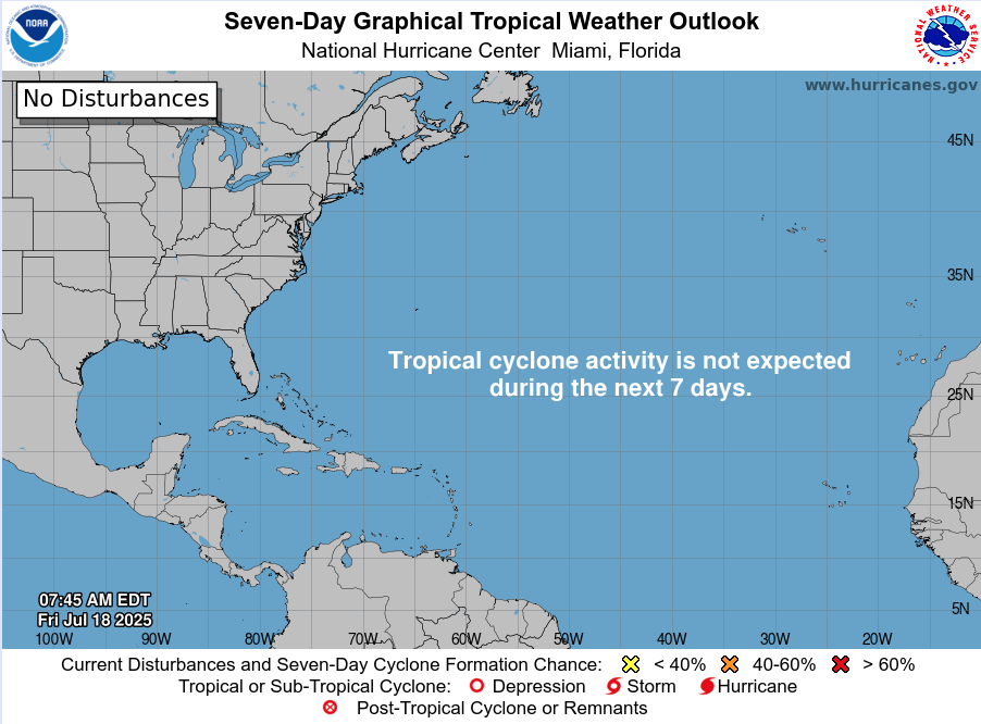
Atlantic Hurricane Outlook – July 18, 2025: Tropics Quiet, But Gulf Moisture Persists
The Atlantic remains free of tropical storms today, but rising ocean heat and evolving atmospheric patterns point to potential development in the coming weeks. Stay prepared with Cat5Prep's daily hurricane outlook.
The Atlantic basin remains relatively quiet as we enter the weekend, with no active tropical cyclones or immediate threats on the map. However, lingering moisture from a weak low in the Gulf of Mexico continues to impact parts of the Southeast with enhanced rain chances. Meanwhile, environmental signals are gradually shifting toward favorability as we move closer to the climatological ramp-up in late July.
Atlantic Basin: Still Quiet, But Watchful
As of this morning’s update from the National Hurricane Center (NHC):
No active tropical cyclones
No named systems or advisories
No tropical development expected over the next 7 days
The basin remains in a holding pattern—but that may change in the weeks ahead.
Satellite imagery courtesy of Windy.com
Sea Surface Temperatures: Running Hot
Ocean heat content continues to build across key development zones:
Gulf of Mexico: Sea surface temperatures (SSTs) remain in the mid-to-upper 80s°F (29–31°C), well above average.
Western Caribbean: Waters continue to warm, supporting deep convection.
Main Development Region (MDR): SSTs between Africa and the Caribbean are approaching thresholds that historically support long-track hurricanes.
These conditions set the stage for rapid intensification when tropical systems do form.
Sea Surface Temperature data courtesy of Windy.com

Wind Shear and Atmospheric Moisture: Becoming More Conducive
While upper-level wind shear remains moderate in parts of the Caribbean and central Atlantic, it is gradually weakening—especially closer to the Gulf. Atmospheric moisture continues to increase:
Mid-level moisture is supporting thunderstorm development
Reduced shear and rising instability create a more supportive environment for potential tropical waves
This combination is worth monitoring as we approach the latter half of July.
Relative Humidity (ECMWF) data courtesy of Windy.com

Wind Shear Courtesy of https://tropic.ssec.wisc.edu/
Saharan Air Layer: A Temporary Shield
Dry air and dust from the Saharan Air Layer (SAL) remain active over the eastern Atlantic:
SAL suppresses convection by drying out the lower atmosphere
It also enhances wind shear, limiting vertical storm growth
This protective layer typically weakens in August
While it currently limits tropical wave development off Africa, its influence is expected to wane soon.
Saharan Air Layer (Dust) data courtesy of Windy.com
Gulf Moisture: Lingering Showers, Low Development Risk
A broad area of low pressure and enhanced moisture remains over the northern Gulf of Mexico:
Development chances remain very low
The system is disorganized, with no surface circulation
Still, heavy rain and localized flooding are possible today along the Gulf Coast, particularly in southern Alabama, the Florida Panhandle, and southeastern Louisiana
This disturbance is more of a rainmaker than a tropical threat but illustrates how even weak lows can impact coastal regions.
Rainfall forecast (ECMWF) courtesy of Windy.com
Florida Forecast: Humid and Storm-Prone
Expect classic July conditions across the state:
North Florida: Highs in the low 90s, partly cloudy, isolated afternoon storms
Central Florida: Around 91°F, muggy, with widespread PM storms
South Florida: Mid-to-upper 80s, very humid, storms possible after 2 PM
Local flooding is possible in poor drainage areas due to repeated rounds of heavy showers.
Thunderstorm forecast (ECMWF) courtesy of Windy.com
Prep Tip of the Day: Review Evacuation Zones
Now is the time to double-check your local evacuation zone and routes:
Know whether you're in a surge or flood-prone area
Identify multiple exit routes in case primary roads are closed
Plan ahead for pets, medication, and transportation
Being familiar with your zone before a storm is one of the best preparedness steps you can take.
Looking Ahead: A Quiet Stretch, But a Shift Is Coming
While the tropics are calm for now, the combination of warming waters, weakening wind shear, and deepening atmospheric moisture signals that a transition to a more active pattern is coming.
Expect activity to increase in late July into early August, as the historical ramp-up in hurricane season begins.
Check back tomorrow for the next update from Cat5Prep.com.

Atlantic Hurricane Outlook – July 17, 2025: Gulf Disturbance Brings Rain Threat, Development Chances Remain Low
A weak system in the Gulf of Mexico—Invest 93L—is bringing heavy rain and storms to the Gulf Coast. Tropical development remains unlikely, but flooding risks persist. The rest of the Atlantic basin stays quiet… for now.
The Atlantic basin remains free of named tropical cyclones today, but a weak low-pressure system—Invest 93L—continues to bring rain and thunderstorms along parts of the Gulf of Mexico coast. While the system is unlikely to develop into a named storm, the primary concern is heavy rainfall and flash flooding across coastal regions from Florida to Louisiana. The rest of the basin remains quiet, but conditions are slowly trending toward increased activity.
Atlantic Basin: Quiet But Not Completely Clear
As of this morning’s update from the National Hurricane Center (NHC):
No active tropical cyclones
One area of interest: Invest 93L
Development odds remain low—about 30% over the next 7 days
No other tropical development expected across the Atlantic basin through the week
Satellite imagery courtesy of Windy.com
Invest 93L: Soaking System Along the Gulf Coast
A disorganized low-pressure area near the northeastern Gulf continues to bring unsettled weather to parts of the Southeast U.S.:
Currently located offshore of the Florida Panhandle
Moving slowly westward toward the central Gulf Coast
Forecast models suggest inland movement into Louisiana or Mississippi by late Wednesday
Tropical development is unlikely due to land interaction and modest wind shear
Main concern:
Heavy rainfall (3–8 inches)
Localized flash flooding
Strong coastal thunderstorms and elevated rip current risk
Active weather alerts courtesy of Windy.com
Sea Surface Temperatures: Fuel Is in Place
Ocean temperatures remain high enough to support development if conditions align:
Gulf of Mexico: 86–88°F in many areas, well above seasonal norms
Western Caribbean: Warm and primed for mid-to-late season activity
Main Development Region (MDR): Gradually warming but still suppressed by dry air
Sea Surface Temperature data courtesy of Windy.com
Wind Shear and Atmospheric Conditions: Mixed Signals
Wind shear is moderate in the Gulf, which may continue to prevent storm organization
Atmospheric moisture is elevated, helping to support widespread thunderstorm activity
No organized convection in the MDR due to Saharan dry air
Relative Humidity (ECMWF) data courtesy of Windy.com

Wind Shear Courtesy of https://tropic.ssec.wisc.edu/
Saharan Air Layer: Still Suppressing the Tropics
A significant plume of dry, dusty air continues to dominate the central and eastern Atlantic:
Disrupts storm cloud development
Introduces additional wind shear
Suppresses convection from African tropical waves
This layer is expected to weaken gradually in late July.
Saharan Air Layer (Dust) data courtesy of Windy.com
Thunderstorm Activity: Gulf Coast Soaker
Florida Panhandle to Louisiana: Strong thunderstorms with heavy rain, especially along I-10 corridor
Central Florida: Scattered PM storms with high humidity and muggy conditions
Western Caribbean: Some convective clusters, but disorganized
Thunderstorm forecast (ECMWF) courtesy of Windy.com
Florida Forecast: Humid, Stormy Conditions Persist
North Florida:
Mid to upper 80s, scattered storms possible
Central Florida:Near 90°F with humid air and afternoon thunderstorms
South Florida:Upper 80s, heavy downpours possible after 2 PM
Localized flooding could occur in urban and low-lying areas.
Rainfall forecast (ECMWF) courtesy of Windy.com
Prep Tip of the Day: Stay Flood-Aware
Even weak systems like Invest 93L can cause dangerous flooding. Today’s tip:
Avoid driving on flooded roads
Review local flood zones and evacuation plans
Elevate valuables if you live in a flood-prone area
Sign up for weather alerts from your local emergency management office
Looking Ahead: A Reminder, Not a Threat
Although Invest 93L isn’t expected to strengthen significantly, it’s a good reminder that even weak systems can cause disruption. As we approach the back half of July, forecasters will continue monitoring the Gulf of Mexico and Western Caribbean, where development tends to increase.
Stay informed. Stay ready. And check back tomorrow for your daily update from Cat5Prep.com.

Atlantic Hurricane Outlook – July 16, 2025: Gulf Disturbance Lingers, Tropics Stay Quiet
A weak low in the Gulf of Mexico brings rain and storms to Florida, but no tropical development is expected. Cat5Prep’s daily update covers real-time conditions, SSTs, and what to watch next.
The Atlantic hurricane basin remains quiet in terms of named storms, but attention continues to center on a weak low-pressure system lingering over the eastern Gulf of Mexico. Although this system remains disorganized and development chances are low, it’s bringing widespread showers and thunderstorms across parts of Florida, the northeastern Gulf, and coastal Georgia.
While no tropical development is expected over the next 7 days, the broader environment is slowly shifting toward favorability, with rising sea surface temperatures, weakening wind shear, and the gradual retreat of the Saharan Air Layer (SAL).
Atlantic Basin Overview
As of the latest NHC update (2:00 PM EDT):
No active tropical cyclones
One disturbance in the Gulf of Mexico (Low development chance)
No tropical formation expected in the next 7 days
Satellite imagery courtesy of Windy.com
Disturbance in the Gulf of Mexico
A broad area of low pressure continues to meander just west of Florida over the northeastern Gulf of Mexico:
Development chances remain low (0% over 48 hours, 10% over 7 days)
System remains non-tropical and disorganized
Producing periods of heavy rainfall, especially across the Florida Panhandle, southern Georgia, and coastal South Carolina
Some gusty winds and isolated flooding may occur, especially in areas with poor drainage
This system is expected to drift inland by late Thursday, reducing any tropical potential.
Radar imagery courtesy of Windy.com
Sea Surface Temperatures (SSTs)
Ocean temperatures remain exceptionally warm, providing high potential energy for storm development once other conditions align:
Gulf of Mexico: 86–89°F (2–4°F above normal)
Western Caribbean: 85–88°F
Main Development Region (MDR): Now reaching 82–84°F across much of the eastern Atlantic
Sea Surface Temperature data courtesy of Windy.com
Atmospheric Conditions
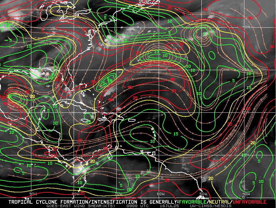
Wind Shear Courtesy of https://tropic.ssec.wisc.edu/
Wind Shear: Still elevated in the western Atlantic and Gulf, but beginning to weaken, particularly near Central America and the western Caribbean.
Moisture: Mid-level moisture continues to increase, especially in the Caribbean and southern Gulf.
Saharan Air Layer: A large, dry SAL continues to stretch across the central Atlantic, suppressing storm formation east of the Lesser Antilles, but it's expected to weaken by early August.
Relative Humidity (ECMWF) data courtesy of Windy.com
Saharan Air Layer (Dust) data courtesy of Windy.com
Thunderstorm & Rainfall Activity
Florida & Gulf Coast: Expect locally heavy rain and thunderstorm clusters tied to the Gulf disturbance.
Western Caribbean: Some disorganized convection continues, but nothing tropical at this time.
West Africa: A new tropical wave has emerged, but faces significant dry air and shear over the central Atlantic.
Rainfall forecast (ECMWF) courtesy of Windy.com
Florida Forecast
Highs: Upper 80s to low 90s°F
Humidity: High, with a heat index reaching the upper 90s
Rain: 60–70% chance of scattered storms in parts of Florida, especially in the afternoon and evening
Winds: Light southeast winds, with occasional gusts during storms
Prep Tip of the Day: Review Flood Insurance Coverage
Standard homeowners insurance does not cover flood damage. Use this calm window to:
Check your flood zone designation
Review your current policy limits
Confirm your coverage start date (flood insurance usually has a 30-day waiting period)
With warm SSTs and an increasingly favorable atmosphere, inland and coastal flood risk rises as we move deeper into hurricane season.
Looking Ahead: Watchful, Not Worrying
Although July 16 brings no immediate storm threats, all eyes remain on the broader Atlantic:
The ingredients for development are aligning: warm water, weakening shear, and increased moisture.
The next two weeks may see the first organized systems forming in the western Caribbean or Gulf of Mexico.
Now is the time to stay informed and finalize preparations—not when a storm is already on the map.

Atlantic Hurricane Outlook – July 15, 2025: Gulf System Organizing, Tropics on Alert
A weak low over Florida is drifting into the Gulf of Mexico, producing heavy rain and prompting close monitoring. While development chances remain low, record-warm waters and shifting winds suggest more activity is coming.
The Atlantic remains officially quiet, but eyes are turning toward the Gulf of Mexico as a broad area of low pressure continues to develop. Though not yet a tropical depression, this system is producing heavy rainfall across parts of Florida and may slowly organize over the next few days. Elsewhere, warm sea surface temperatures and improving atmospheric conditions continue to set the stage for increased activity as July progresses.
Atlantic Basin: Watching the Gulf
As of this morning’s update from the National Hurricane Center (NHC):
No named tropical cyclones
One area of interest: Disturbance near Florida
Development potential: Low over 48 hours (10%), Slightly higher over 7 days (20%)
A broad, weak surface trough stretching across southern Florida is generating scattered storms and heavy rainfall. As it drifts westward into the Gulf of Mexico, slight development is possible—though wind shear and dry air may continue to limit its growth in the near term.
Regardless of tropical classification, this system is expected to bring:
Heavy rainfall across Florida and the Gulf Coast
Localized flash flooding
Coastal thunderstorms and rough surf
Satellite imagery courtesy of Windy.com
Sea Surface Temperatures: Primed and Warming
Waters across much of the Atlantic basin are running well above average:
Gulf of Mexico: 87–89°F (30–32°C) across much of the basin—ideal for storm formation
Caribbean Sea: Persistently warm, with temperatures near or above 86°F (30°C)
Main Development Region (MDR): Trending well above average for mid-July
This level of ocean heat content supports rapid intensification potential for any system that organizes in the coming weeks.
Sea Surface Temperature (ECMWF Analysis) courtesy of Windy.com
Atmospheric Conditions: Becoming More Favorable

Wind Shear Courtesy of https://tropic.ssec.wisc.edu/
Wind Shear: Moderate across the Gulf and Caribbean, but forecast models show a gradual easing through late week
Moisture Levels: Improving, especially in the western Caribbean and southern Gulf
Upper-Level Winds: Starting to show a less hostile pattern over the Gulf and MDR
Overall, the atmospheric profile is trending toward neutral to favorable—a subtle but important change.
Relative Humidity data (ECMWF) courtesy of Windy.com
Saharan Air Layer (SAL): Retreating Slowly
Dry air remains across parts of the eastern Atlantic but is beginning to loosen its grip:
Still suppressing deep convection off the African coast
Expected to retreat westward and weaken through the next 7–10 days
This transition opens the door for tropical waves to survive and organize
Saharan Air Layer (Dust) data courtesy of Windy.com
Florida & Gulf Coast Forecast: Wet and Stormy
The disturbance currently over Florida is impacting much of the region:
Florida Peninsula
Scattered to widespread showers and storms today
Localized flooding possible, especially in urban areas
Highs in the upper 80s to low 90s°F
Northern Gulf Coast (AL/MS/FL Panhandle)
Cloudier skies and increasing storms through tomorrow
Elevated rainfall totals possible
Winds 10–20 mph with gusty thunderstorms
Radar imagery courtesy of Windy.com
Prep Tip of the Day: Secure Outdoor Items
With storms increasing across the Southeast:
Bring in or secure loose outdoor items like patio furniture, garden tools, and trash bins
Clear storm drains and gutters to reduce urban flooding risk
Monitor flash flood alerts in flood-prone neighborhoods
Looking Ahead: A Pattern Shift Is Coming
Although no named systems are expected in the next few days, the Gulf disturbance is a reminder that even weak systems can cause significant impacts. Sea surface temperatures and weakening wind shear are setting the table for development in the latter half of July.
Stay tuned, stay prepared, and check back daily with Cat5Prep for accurate, actionable updates.
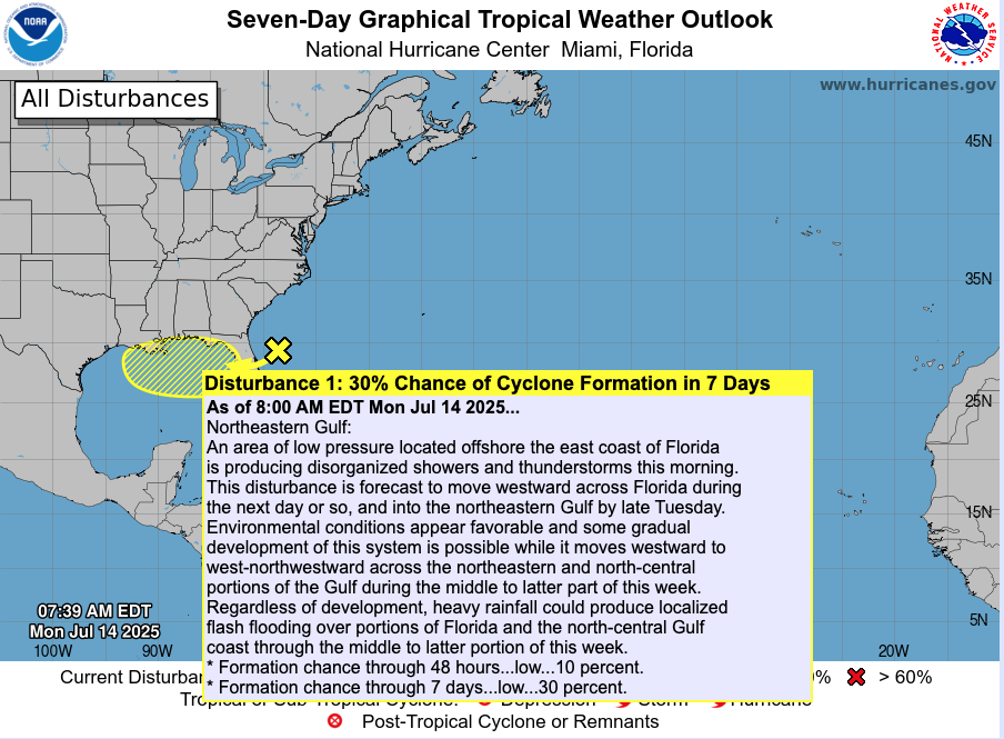
Atlantic Hurricane Outlook – July 14, 2025: Gulf Disturbance Signals Season’s Shift
A weak trough near Florida could organize as it moves into the Gulf of Mexico this week. While not yet a named system, heavy rain and flooding may impact Florida and Gulf Coast states. Stay informed and prepared.
The Atlantic basin remains mostly calm, but the tropics are waking up. A trough of low pressure is moving off the Southeast U.S. coast and entering the Gulf of Mexico, where it's now being monitored for potential tropical development later this week.
Atlantic Basin: Early Signs of Activity
No named tropical cyclones currently.
The trough is producing disorganized clouds and showers along the Southeast coast and across Florida.
According to the NHC, this system has about a 30% chance of organizing into a tropical depression or storm over the next seven days, with a 10% chance in 48 hours.
If it develops, it could move west across the Gulf toward Louisiana and Texas by late week.
Satellite view via Windy.com
Foundation: Ocean & Atmosphere Basics
Sea Surface Temperatures (SSTs) are 2–4°F above average in the Gulf, Caribbean, and Main Development Region—providing the warm fuel needed for development.
Sea Surface Temperature via Windy.com

Wind Shear Courtesy of https://tropic.ssec.wisc.edu/
Wind shear remains moderate-to-strong across much of the basin; however, conditions in the northeastern Gulf may become more favorable for storm organization.
Saharan dust continues to suppress development in the eastern Atlantic, but this trough is well west of that region.
Saharan Air Layer (Dust) via Windy.com
Local Weather: Rain and Thunderstorms Ahead
Florida: Expect multiple rounds of heavy rain and thunderstorms today through Wednesday as the trough crosses the peninsula.
Gulf Coast (AL, MS, LA, TX): Showers, thunderstorms, and flooding potential increase by mid-to-late week.
Attention zones: Tampa, Orlando, Dolphins could see over 6″ of rain; Houston and Mobile might experience heavy downpours and gusts.
Thunderstorm Forecast (ECMWF) via Windy.com
Prep Tip: Heavy Rain Trumps Wind Now
With flooding as the primary threat:
Ensure your home’s drainage systems are clear.
Prepare sandbags and supplies if you live in low-lying or flood-prone zones.
Keep flashlight, battery-powered radio, and emergency kits on hand.
Continue monitoring NOAA Weather Radio and local alerts as storms advance.
Looking Ahead: Watch This Week Carefully
As the trough moves into the Gulf, developing into a tropical depression or storm is possible.
Even without full tropical development, heavy rain and localized flooding pose a risk to the Southeast U.S. and Gulf states.
This activity could become the season’s first system to affect U.S. mainland—track it closely over the next 3–7 days.
Stay tuned to Cat5Prep.com for your next daily update—this season may be shifting right before our eyes.
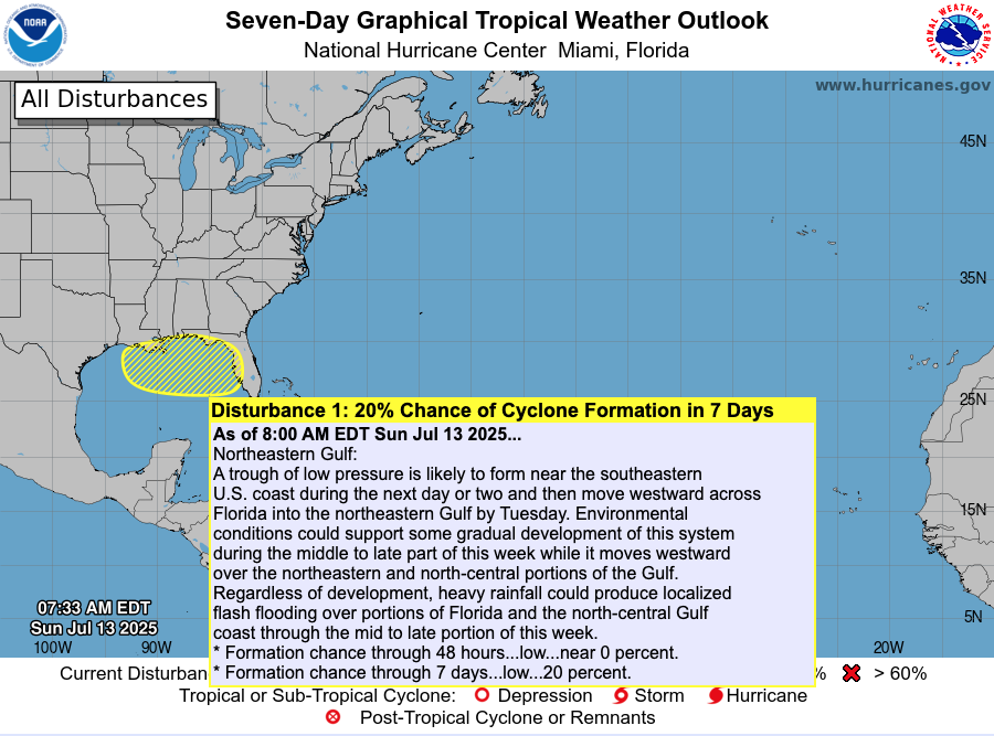
Atlantic Hurricane Outlook – July 13, 2025: Tropics Quiet, Gulf Trough Under Watch
No named storms today, but a low-pressure trough drifting toward the Gulf of Mexico could bring rain and potential tropical development later this week.
The Atlantic basin remains calm today, with no active named storms. However, meteorologists are tracking a low-pressure trough emerging off the Southeast U.S. coast, gradually drifting into the Gulf of Mexico. This system has a low (20%) chance of organizing into a subtropical or tropical system later this week .
Atlantic Overview: Quiet But Evolving
As per the 8 AM EDT NHC Tropical Weather Outlook:
No active tropical cyclones across the basin.
The Southeast U.S. trough is expected to push into the Gulf by Tuesday.
Formation chances: <1% in next 48 hours, ~20% over 7 days .
Though not tropical now, its movement may increase rainfall and raise attention if organization begins.
Satellite view via Windy.com
Sea Surface Temperatures: A Warm Platform
The Gulf of Mexico continues to show SSTs 2–4°F above average, providing a warm environment for storm development later this season.
Caribbean and Main Development Region (MDR) SSTs also remain elevated, keeping hurricane fuel accessible .
Sea Surface Temperature via Windy.com
Atmospheric Setup: Suppression in Play

Wind Shear Courtesy of https://tropic.ssec.wisc.edu/
Wind shear remains moderately strong across much of the basin, hindering storm development.
Saharan dust is still prevailing over the eastern Atlantic, suppressing early-season storm growth.
Moisture levels are slowly increasing in the Gulf and Southeast U.S., signaling gradual support for convection.
Saharan Air Layer (Dust) via Windy.com
Regional Weather: Rain on the Rise
Expect increased showers and thunderstorms along the Southeast U.S. and Gulf coasts as the trough approaches.
Florida will likely see scattered afternoon storms, typical for July, especially as the trough draws moisture inland.
Thunderstorm Forecast (ECMWF) via Windy.com
Prep Tip of the Day: Be Rainwise
Even without strong winds, heavy rainfall can pose serious hazards:
Track the trough’s movement—it could bring localized flash flooding to Gulf coast areas.
Ensure storm drains and sump pumps are clear and functional.
Keep sandbags and quick barriers ready if you're in low-lying zones.
Test your NOAA Weather Radio and mobile alerts to stay ahead of rainfall warnings.
Looking Ahead: Waters Stay Warm—Storms Could Spark
Although the tropics are peaceful now, the combination of warm ocean temperatures, easing atmospheric inhibitors, and growing seasonal moisture suggest readiness for evolution. The trough may serve as the first spark of Gulf activity, with a watchful eye needed through mid- to late-week.
Stay alert and check back tomorrow for your latest update from Cat5Prep.com.

Atlantic Hurricane Outlook – July 9, 2025: Calm Seas Persist Amid Seasonal Build
The Atlantic remains quiet today, with no active storms and no development expected. But record-warm waters and shifting atmospheric patterns suggest that tropical activity could ramp up soon.
Mid-July typically signals more tropical activity—but today, the Atlantic remains unusually quiet. According to the latest NHC updates, no tropical cyclones are present, with no expected development over the next seven days. Despite the current calm, strong indicators suggest the season’s intensity is primed to rise.
Atlantic Basin: All Clear for Now
No active systems in the Atlantic, Caribbean, or Gulf
NHC forecast maintains zero development chances across the basin
This lull is rare for July and may end soon as heat and moisture build
Satellite view via Windy.com
Seasonal Outlook: Above-Normal Conditions Ahead
CSU’s July update continues to forecast an above-average season:
~17 named storms, including ~9 hurricanes and ~4 major hurricanes .NOAA similarly predicts 13–19 named storms, with a 60% chance of a busier-than-average season.
Sea Surface Temperatures: High Heat Levels
Atlantic SSTs remain well above normal—2–4°F above average—in the Gulf, Caribbean, and MDR
These elevated temperatures continue to provide plenty of energy for storm formation in the weeks ahead
Sea Surface Temperature via Windy.com
Atmospheric Conditions: Secondary Barriers Easing

Wind Shear Courtesy of https://tropic.ssec.wisc.edu/
Wind shear remains moderate-to-high, particularly in the eastern Atlantic—temporarily limiting development
Saharan Air Layer (SAL) and occasional dry mid-level air still suppress convection but are expected to diminish
Moisture is steadily increasing, with abundant humidity projected across storm-prone regions
Saharan Air Layer (Dust) via Windy.com
What to Watch Next
Upcoming Infrared and visible satellite loops for signs of organization
Shifts in wind shear over the Gulf and Caribbean
Any African easterly waves gaining moisture and structure
Wind Gust Accumulation Forecast (ECMWF) via Windy.com
Early July Trends
Only one named storm (Chantal) has formed so far, but it remained weak and quickly dissipated
History shows many July systems originate in the Gulf, Caribbean, or off the Southeast U.S. coast
Outlook: Active Patterns Brewing
While quiet now, the combination of warm SSTs, moist air, and weakening shear/SAL signals a rising likelihood of Atlantic development
Hurricane Season Peak is still ahead—August through October—but increased vigilance is essential now
Prep Tip of the Day: Check Your Alert Systems
With the season expected to intensify:
Confirm NOAA Weather Radio is operational
Enable emergency alerts on all devices
Update your hurricane kit and evacuation plan
Bookmark Cat5Prep.com and the National Hurricane Center for future updates
The Atlantic remains calm—but the foundation for tropical activity is strengthening daily. Stay alert, stay prepared, and check back tomorrow for your next Cat5Prep.com outlook.

Atlantic Hurricane Outlook – June 20, 2025: Tropics Hold Quiet as Atlantic Patterns Begin to Shift
The Atlantic remains calm with no storms expected, but warm waters and shifting atmospheric patterns hint that the quiet may not last. A developing Atlantic Niña could hit a reversal and amplify activity later this season.
As we close out the third week of the 2025 Atlantic hurricane season, the basin remains quiet. No named storms or tropical disturbances are being monitored by the National Hurricane Center (NHC), and no development is expected over the next 7 days. However, behind this calm lies a subtle shift in Atlantic patterns that may influence storm activity in the weeks ahead.
Atlantic Basin: All Clear—for Now
As of the latest NHC update (8 AM EDT, June 20):
No active tropical cyclones
No areas of interest
No tropical development expected through late June
This type of quiet is typical for mid-June, historically a transitional period before activity ramps up in July and peaks from August to October.
Satellite view via Windy.com
Sea Surface Temperatures: Still Hot, Still Fuel
Sea surface temperatures (SSTs) across much of the Atlantic remain well above normal:
Gulf of America (Mexico): Mid to upper 80s°F (29–31°C), 2–4°F above average
Western Caribbean: Similar anomalies, particularly near the Yucatán and Cuba
Main Development Region (MDR): Still warming gradually, trending toward conditions that could support long-track storms later this season
Warm SSTs are a critical energy source for hurricanes—and the heat is already in place.
Sea Surface Temperature (ECMWF Analysis) via Windy.com
Atmospheric Conditions: Neutral ENSO, but Atlantic Cooling Briefly
While the Pacific remains in an ENSO-neutral phase, a rare “Atlantic Niña” has recently emerged—marked by cooler-than-average sea surface temperatures in the eastern tropical Atlantic off the coast of Africa, as seen in the NOAA Coral Reef Watch chart below with a pocket of blue.
This can temporarily suppress early-season hurricane formation by reducing convection and stabilizing the atmosphere
However, models indicate that this pattern may reverse in July, shifting into a warmer Atlantic Niño phase, which typically boosts tropical activity
So, while the Atlantic Niña may be limiting development now, forecasters are closely watching the timing of this transition. Safe money would be on a reversal, which could super charge storm breeding.

Overall Scope of Sea Temperature Anomalies
Saharan Air Layer: Still Limiting Tropical Waves

Wind Shear Courtesy of https://tropic.ssec.wisc.edu/
A strong Saharan Air Layer (SAL) remains entrenched across the tropical Atlantic:
Dry, dusty air suppresses thunderstorm development
Increases stability and upper-level wind shear
Common in June, but typically weakens by mid-July
For now, SAL continues to act as a shield against organized tropical development in the Main Development Region.
Saharan Air Layer (Dust) data via Windy.com
Thunderstorm Activity: Mostly Seasonal and Local
While no tropical organization is underway, convection continues to pop up in key regions:
Florida and Gulf Coast: Afternoon storms due to heat and humidity
Western Caribbean: Scattered convection, but unorganized
Eastern Atlantic: A few tropical waves exiting Africa remain weak and embedded in dry air
These thunderstorms are typical for the season and do not currently show signs of tropical development.
Thunderstorm Forecast (ECMWF) via Windy.com
Florida Forecast
Highs: Upper 80s to low 90s°F (31–33°C)
Humidity: High
Afternoon Storms: Scattered area of thunderstorms likely after 2 PM
Winds: Light and variable, with storm gusts possible
Flooding in low-lying areas is possible if storms linger over one area.
Rainfall Forecast (ECMWF) via Windy.com
Prep Tip of the Day: Restock Pet Supplies
Don’t forget your furry family members when preparing for hurricane season:
Have a two-week supply of pet food, medications, and water
Keep vaccination records and vet contact info in your go-bag
Prepare a small pet first-aid kit
Label pet carriers clearly and store them where they’re easy to grab
Looking Ahead: Transition Coming
For now, the Atlantic basin is calm. But forecasters continue to watch:
Warm SSTs
Easing wind shear
Gradual return of moisture
Potential reversal from Atlantic Niña to Atlantic Niño
All signs point to a more active environment forming as we move into July. Stay alert, stay prepared, and check back tomorrow for your daily hurricane outlook from Cat5Prep.com.

Atlantic Hurricane Outlook – June 19, 2025: Still Down South – Pacific Watches Erick
The Atlantic remains storm-free, but Hurricane Erick—a powerful Category 4 storm—gains strength in the Eastern Pacific. Learn what this means for the Atlantic basin and why now is the time to prepare.
The Atlantic basin remains quiet today, with no active tropical cyclones and no development expected over the next 7 days, according to the National Hurricane Center’s latest 2 AM and 8 AM EDT outlooks nhc.noaa.gov. While the Atlantic sleeps, attention is turning to a powerful system in the Pacific.
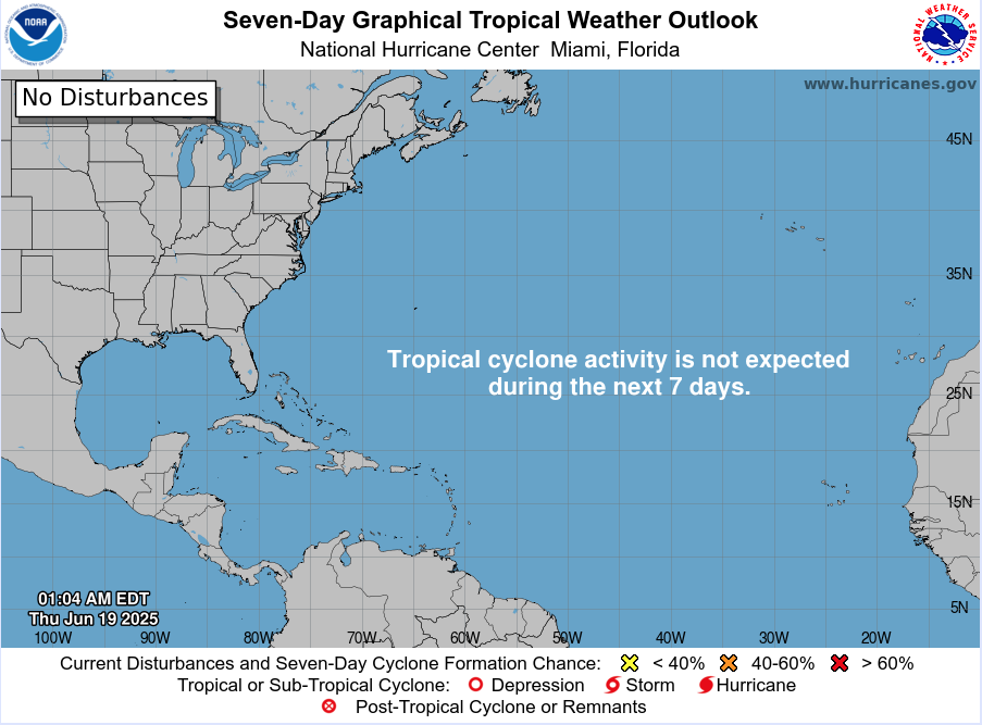
Atlantic Basin: Calm Waters, No Alerts
There are still no named storms or areas under tropical monitoring. The graphical and textual 7-day outlooks show zero development chance, meaning the basin continues its quiet stretch early in the season . Early June silence isn’t unusual—but with warm seas in place, conditions could shift quickly.
Satellite view via Windy.com
Pacific Perspective: Erick Now a Category 4
In the Eastern Pacific, Hurricane Erick has rapidly intensified into an “extremely dangerous” Category 4 storm with 145 mph sustained winds, now only about 70 miles west-southwest of Puerto Ángel, Mexico, heading for landfall.
This storm is expected to bring destructive winds, brutal rainfall (8–16 inches), mudslides, and severe coastal flooding across southern Mexico.


Sea Surface Temperatures: Atlantic Warming Continues
Gulf & Western Caribbean: SSTs remain warm at 84–88 °F, maintaining energy supply for potential tropical systems.
Main Development Region (MDR): Ocean temperatures are also above normal, setting the stage for Atlantic activity later in the season.
Sea Surface Temperature via Windy.com
Atmospheric Conditions: Suppressive Air Masses

Wind Shear Courtesy of https://tropic.ssec.wisc.edu/
Wind shear: Still moderate to high across key development areas, limiting near-term storm formation.
Saharan Air Layer (SAL): A persistent dust plume continues to suppress early-season activity in the eastern Atlantic.
Moisture: Slowly increasing in the Gulf and western Caribbean, helping build storm potential.
Saharan Air Layer (Dust) via Windy.com
Daily Weather: Standard June Patterns
Florida & Southeast U.S.: Afternoon and evening thunderstorms remain widespread but non-tropical.
Caribbean & Atlantic: Quiet and storm-free, with no signs of developing systems.
Air Quality: Possible haze in Florida due to advancing Saharan dust.
Thunderstorm Forecast (ECMWF) via Windy.com
Florida Forecast (June 19)
Highs: Upper 80s to low 90s °F (31–33 °C)
Humidity: High—typical muggy summer
Rain: Scattered PM showers and thunderstorms
Visibility: Hazy in some areas
Winds: Light, occasional gusts near storm cells
Rainfall Forecast (ECMWF) via Windy.com
Prep Tip of the Day: Cross-Basin Awareness
Even without Atlantic storms, Pacific activity underscores a critical point:
Monitor systems across basins, not just the Atlantic
Understand conditions building globally—warm seas, dust, wind shear shifts
Use this calm time to update emergency contacts, test NOAA radios, and finalize supply kits
Looking Ahead: Calm Now, But It Won’t Last
No Atlantic activity is expected this week, but elevated ocean temperatures, decreasing wind shear, and diminishing dust suggest a shift is coming. Hurricane Erick in the Pacific could hint at similar atmospheric boosts affecting the Atlantic soon.
Stay tuned for daily updates from Cat5Prep.com—the next tropical trigger could arrive sooner than you think.