
Atlantic Hurricane Outlook – July 9, 2025: Calm Seas Persist Amid Seasonal Build
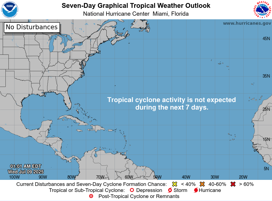
The Atlantic remains quiet today, with no active storms and no development expected. But record-warm waters and shifting atmospheric patterns suggest that tropical activity could ramp up soon.
Mid-July typically signals more tropical activity—but today, the Atlantic remains unusually quiet. According to the latest NHC updates, no tropical cyclones are present, with no expected development over the next seven days. Despite the current calm, strong indicators suggest the season’s intensity is primed to rise.
Atlantic Basin: All Clear for Now
No active systems in the Atlantic, Caribbean, or Gulf
NHC forecast maintains zero development chances across the basin
This lull is rare for July and may end soon as heat and moisture build
Satellite view via Windy.com
Seasonal Outlook: Above-Normal Conditions Ahead
CSU’s July update continues to forecast an above-average season:
~17 named storms, including ~9 hurricanes and ~4 major hurricanes .NOAA similarly predicts 13–19 named storms, with a 60% chance of a busier-than-average season.
Sea Surface Temperatures: High Heat Levels
Atlantic SSTs remain well above normal—2–4°F above average—in the Gulf, Caribbean, and MDR
These elevated temperatures continue to provide plenty of energy for storm formation in the weeks ahead
Sea Surface Temperature via Windy.com
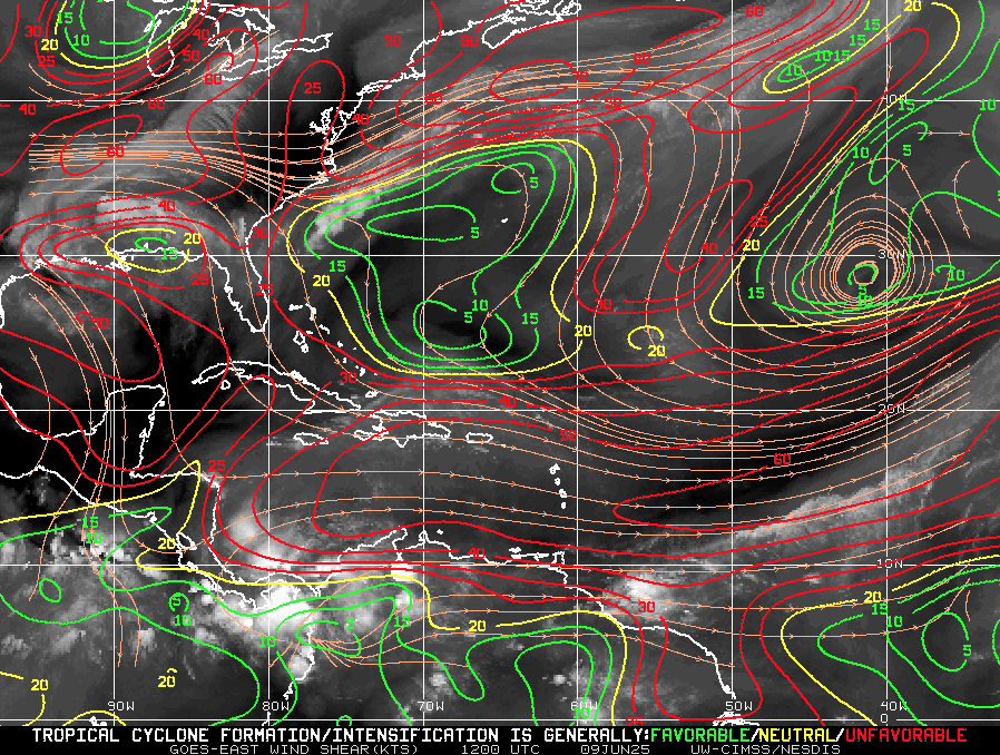
Atmospheric Conditions: Secondary Barriers Easing

Wind Shear Courtesy of https://tropic.ssec.wisc.edu/
Wind shear remains moderate-to-high, particularly in the eastern Atlantic—temporarily limiting development
Saharan Air Layer (SAL) and occasional dry mid-level air still suppress convection but are expected to diminish
Moisture is steadily increasing, with abundant humidity projected across storm-prone regions
Saharan Air Layer (Dust) via Windy.com
What to Watch Next
Upcoming Infrared and visible satellite loops for signs of organization
Shifts in wind shear over the Gulf and Caribbean
Any African easterly waves gaining moisture and structure
Wind Gust Accumulation Forecast (ECMWF) via Windy.com
Early July Trends
Only one named storm (Chantal) has formed so far, but it remained weak and quickly dissipated
History shows many July systems originate in the Gulf, Caribbean, or off the Southeast U.S. coast
Outlook: Active Patterns Brewing
While quiet now, the combination of warm SSTs, moist air, and weakening shear/SAL signals a rising likelihood of Atlantic development
Hurricane Season Peak is still ahead—August through October—but increased vigilance is essential now
Prep Tip of the Day: Check Your Alert Systems
With the season expected to intensify:
Confirm NOAA Weather Radio is operational
Enable emergency alerts on all devices
Update your hurricane kit and evacuation plan
Bookmark Cat5Prep.com and the National Hurricane Center for future updates
The Atlantic remains calm—but the foundation for tropical activity is strengthening daily. Stay alert, stay prepared, and check back tomorrow for your next Cat5Prep.com outlook.

Atlantic Hurricane Outlook – June 9, 2025: Tropical Tranquility Continues
No storms are expected this week as the Atlantic hurricane season stays quiet. Warm waters and shifting wind patterns suggest activity could increase later in June. Stay prepared with today’s full update.
The ninth day of the 2025 Atlantic hurricane season dawns with quiet conditions—no active storms or signs of tropical development are present. The National Hurricane Center (NHC) confirms that no tropical cyclone formation is expected in the Atlantic Basin over the next seven days. It's a typical early-June lull, but with warming waters and shifting atmospheric dynamics, conditions may change quickly.
Atlantic Basin: Clear Skies, No Areas of Concern
No active tropical cyclones
No disturbances or systems being monitored
7-day outlook shows no development expected
This continued calm aligns with seasonal norms—but forecasters are keeping a cautious eye on the evolving environment.
Satellite imagery courtesy of Windy.com
Sea Surface Temperatures: Warm and Watchful
Gulf of America (Mexico) & Western Caribbean: Sea surface temperatures remain in the low‑to‑mid‑80s °F (27–29 °C), sufficient to fuel tropical systems.
Main Development Region (MDR): SSTs are gradually rising, though not yet at peak summer levels.
These ongoing warm waters provide a key energy source for future storm formation.
Sea Surface Temperature (SST) data courtesy of Windy.com
Atmospheric Conditions: Still Mixed, Not Conducive
Wind Shear: Moderate to high shear persists, particularly in western Caribbean and central Atlantic—suppressing thunderstorm organization.
Moisture Levels: While mid-level atmospheric moisture is increasing, it's not yet sufficiently abundant or widespread to support cyclone development.
Together, these factors continue to limit tropical activity.
Wind Shear Courtesy of https://tropic.ssec.wisc.edu/
Saharan Air Layer: A Persistent Block
A strong plume of dry, dusty Saharan air remains entrenched over the central and eastern Atlantic.
This Saharan Air Layer (SAL) injects dryness and wind shear that further inhibit storm formation.
Expect suppression to continue into mid-June when SAL influence typically begins to decline fox35orlando.com.
Saharan Air Layer (Dust) data courtesy of Windy.com
Thunderstorm Activity: Routine, Non-Tropical
Florida & Southeast U.S.: Scattered afternoon storms—typical for early June.
Western Caribbean: A few isolated, disorganized cells persist, but show no signs of development.
Eastern Atlantic: Quiet and without organized convection.
These systems are seasonal and not related to hurricane development.
Thunderstorm data courtesy of Windy.com
Florida Forecast (All Regions)
Highs: Upper 80s to low 90s °F (31–33 °C)
Humidity: Moderate to high, creating a muggy atmosphere
Rain: Isolated to scattered afternoon and evening storms
Winds: Light and variable
A classic early-summer day with palm trees swaying but no storm threats.
Rainfall forecast courtesy of Windy.com
Prep Tip of the Day: Review Evacuation Plans
Use this calm window to double-check your evacuation readiness:
Reconfirm your evacuation zone and route.
Update your household emergency plan, including pets and special needs.
Keep contact numbers accessible, especially local officials and emergency services.
Test your NOAA weather radio and ensure alerts are activated on mobile devices.
Looking Ahead: Still Calm, But Eyes Remain Open
No tropical development is forecast this week, but the environment is slowly warming and becoming more favorable:
Warm water concentrations persist
Wind shear may decrease in the coming weeks
Moisture levels are increasing regionally
While it's still quiet, conditions are edging toward potential activity. Continue to check in daily for updates as Cat5Prep.com monitors the evolving season.

Atlantic Hurricane Outlook – June 6, 2025: Quiet Tropics, No Development Expected
June 6, 2025: No named storms or tropical threats in the Atlantic basin today, but signs of change are emerging. Sea surface temperatures continue to climb, and wind shear may weaken in the coming weeks. Now’s the time to review your hurricane prep plan.
The 2025 Atlantic hurricane season continues with a calm week, as no tropical cyclones or areas of concern are present. The National Hurricane Center (NHC) confirms no tropical development is expected over the next seven days, marking a quiet yet cautious start to June.

Atlantic Basin: Clear Skies for Now
From the 8 AM EDT Tropical Weather Outlook issued June 6:
No active tropical cyclones
No areas of concern
No development expected in the next seven days
The NHC’s maps and guidance reflect this assessment, indicating a continued quiet period. Notably, previous offshore coastal disturbances have been dropped and are no longer being tracked.
Satellite imagery courtesy of Windy.com
Sea Surface Temperatures: Stable But Still Warm
Warm SSTs persist in regions key to hurricane development:
Gulf of America (Mexico) & Western Caribbean: Remain seasonally warm (low to mid-80s°F)
Main Development Region (MDR): Still trending above normal for early June
While SSTs provide essential fuel, other atmospheric factors currently suppress development.
Sea surface temperature data courtesy of Windy.com
Wind Shear & Moisture: Conditions Not Yet Favorable
Wind Shear: Moderate across much of the basin, particularly in the western Caribbean and central Atlantic
Atmospheric Moisture: Rising gradually, but not yet supportive of storm formation
These conditions reduce the likelihood of tropical development in the immediate future.

Wind Shear Courtesy of https://tropic.ssec.wisc.edu/
Saharan Air Layer: Suppression in Full Effect
A strong plume of Saharan dust continues to suppress Atlantic convection:
Dry air and elevated shear persist across the eastern tropical Atlantic and MDR apnews.com
The SAL remains a key barrier to any early-season system development
Expect this barrier to weaken later in June
Saharan Air Layer (SAL) dust data courtesy of Windy.com
Thunderstorm Activity: Localized, Non-Tropical
Florida & Southeastern U.S.: Scattered afternoon thunderstorms—normal for this season
Western Caribbean: Isolated, disorganized showers and storms with no rotation
Eastern U.S. Coast: No significant organized convection detected
These are routine summer thunderstorms—not tropical systems.
Thunderstorm forecast data courtesy of Windy.com
Florida Forecast: Typical Early Summer Conditions
Expect another classic June day:
Highs: Upper 80s to low 90s°F (31–33 °C)
Humidity: Moderate to high, creating muggy conditions
Rain: Scattered afternoon and evening showers likely
Winds: Light and variable
Rainfall forecast data courtesy of Windy.com
Prep Tip of the Day: Emergency Alerts and Insurance
Take advantage of today’s calm to:
Confirm your emergency alert subscriptions, including text and email
Review your insurance coverage and update policy details if needed
Gather digital and physical copies of critical documents
Familiarize yourself with evacuation zones in your area
Looking Ahead: Still Calm, But Stay Vigilant
NHC projections show no tropical development through June 13–14, but underlying conditions—particularly warm waters and gradually weakening shear—will become increasingly favorable. The primary barriers are the Saharan dust layer and fluctuating atmospheric moisture.
Remember: hurricanes can form quickly when conditions align. Continue to monitor daily forecasts at Cat5Prep.com.

Atlantic Hurricane Outlook – May 30, 2025: The Calm Before the Surge
Tropical Storm Alvin has formed in the Eastern Pacific, signaling the start of the 2025 season. While the Atlantic remains quiet, activity is brewing in the tropics. See SST, SAL, and EFI maps to track what's coming.
As we approach the official start of the Atlantic hurricane season on June 1, the Atlantic basin remains tranquil. The National Hurricane Center (NHC) reports no active tropical systems or significant disturbances across the Atlantic Ocean, Caribbean Sea, or Gulf of Mexico.
However, this period of calm may be short-lived. Environmental conditions—such as record-warm sea surface temperatures and a neutral El Niño–Southern Oscillation (ENSO) phase—are aligning to potentially fuel an active hurricane season.
Eastern Pacific Activity: Tropical Storm Alvin Forms
While the Atlantic remains quiet, the Eastern Pacific has seen its first named storm of the 2025 season: Tropical Storm Alvin.
Location: Approximately 565 miles south-southeast of the southern tip of Mexico’s Baja California Peninsula
Movement: Northwest at 12 mph
Maximum Sustained Winds: 60 mph
Forecast: Alvin is expected to strengthen through early Friday but is anticipated to weaken by late Friday as it encounters cooler waters
(Associated Press source)
Although Alvin poses no direct threat to land, its formation indicates that tropical activity is beginning in the Pacific.
Sea Surface Temperatures: Fuel for Future Storms
The Atlantic's sea surface temperatures (SSTs) are notably warm, providing ample energy for potential storm development:
Gulf of Mexico and Caribbean Sea: SSTs are running 2–4°F above average, with some areas exceeding 86°F (30°C)
North Atlantic: Experiencing its third-warmest May on record
These elevated temperatures are conducive to tropical cyclone formation and intensification.
Saharan Dust: A Temporary Inhibitor
The Saharan Air Layer (SAL) continues to transport dry, dusty air across the Atlantic, suppressing tropical development by:
Drying out the mid-level atmosphere
Increasing vertical wind shear
Inhibiting cloud formation
This dust presence is expected to diminish in the coming weeks, potentially allowing for increased tropical activity as the season progresses.
Preparation Tips: Stay Ready
With the Atlantic hurricane season imminent, it's crucial to visit our Prep Blog and:
Review Emergency Plans: Ensure evacuation routes and communication plans are up to date
Check Emergency Kits: Stock up on essentials like water, non-perishable food, medications, and batteries
Stay Informed: Monitor updates from the NHC and local weather services
Looking Ahead
While the Atlantic remains calm for now, the formation of Tropical Storm Alvin in the Pacific underscores the importance of vigilance. As environmental conditions become more favorable, the likelihood of tropical development in the Atlantic increases.
Stay prepared and stay informed.

*This is an Amazon affiliate link. We earn a commission if you buy through it.