
The Atlantic's Invisible Shield: How the Saharan Air Layer (SAL) Deters Hurricanes from Forming

As we move deeper into hurricane season, residents of Florida and coastal communities across the Gulf and Atlantic should stay alert—even if the tropics seem quiet for now. While the current forecast shows a relatively calm Atlantic basin, with only weak disturbances and unorganized tropical waves, the underlying atmospheric dynamics are shifting.
Sea surface temperatures are running abnormally high, a key ingredient that fuels hurricanes. But despite this thermal energy, one powerful—and often invisible—force continues to suppress storm formation: the Saharan Air Layer (SAL).
Let’s explore how this dry, dusty air mass from Africa acts as nature’s own hurricane deterrent—and why understanding it can help us stay prepared.
Dust & SAL data from Windy.com
How Hurricanes Form: 5 Essential Ingredients

Emergency Glow Sticks
12-hour light, waterproof, and individually wrapped — ideal for storms, survival kits & under $15.
Before we explore how the SAL disrupts hurricane development, here’s a quick refresher on what tropical cyclones need to form:
Warm ocean water (≥ 80°F / 26.5°C): Provides the energy through evaporation.
Low vertical wind shear: Allows storms to organize and grow vertically.
Mid-level atmospheric moisture: Especially between 3,000 and 5,500 meters altitude (700–500 hPa).
A pre-existing disturbance: Often an African Easterly Wave or low-pressure area.
Coriolis effect: Needed for rotation—cyclones can't form too close to the equator.
When all five align, especially from mid-August through September, the Atlantic becomes highly active. But the Saharan Air Layer can derail this process at every level.
What Is the Saharan Air Layer (SAL)?
The Saharan Air Layer is a large mass of dry, dusty, and stable air that forms over the Sahara Desert and rides westward on strong trade winds. It typically hovers between 5,000 and 20,000 feet (1,500–6,000 meters) above sea level, above the moist marine boundary layer.
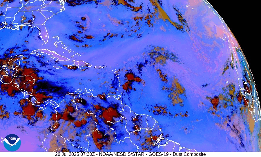
NOAA/NESDIS/STAR – GOES-19 Dust Composite – July 26, 2025 (Tropical Atlantic - MDR)
Key SAL Characteristics:
Most active from late spring through early fall (especially June–August)
Contains very dry air, sometimes less than 30% relative humidity
Creates strong mid-level winds and atmospheric temperature inversions
Loaded with mineral dust, visible on satellite as brown or orange haze

Odoland Portable LED Lantern + Fan
Combo lantern and fan — perfect for hurricane season or camping. Lightweight, battery-powered, and under $20.
🛒 Buy Now on AmazonHow the SAL Blocks Hurricanes: 3 Key Mechanisms
1. Dry Air Entrapment: Starving the Storm
Tropical systems need moist air to build thunderstorms. The SAL introduces very dry air at mid-levels, which gets pulled into developing systems.
Result:
This “entrainment” of dry air evaporates storm clouds, creating downdrafts that choke off convection. It literally dries the system out before it can strengthen.
Forecaster Tip:
Look for 700–500 hPa humidity levels below 30%—a strong SAL signature that’s hostile to storm growth.
Relative Humidity (700 hPa) data courtesy of Windy.com
2. Wind Shear: Disrupting Vertical Alignment
The SAL brings strong easterly winds in the mid-levels of the atmosphere, which increases vertical wind shear.
Result:
Storms get “decapitated”—their upper and lower parts are pulled apart. Without vertical alignment, they can’t intensify.
Analogy:
Like pushing a spinning top sideways—eventually, it wobbles and falls over.
Wind data at 850hPa from Windy.com
3. Atmospheric Stability: Capping Convection
The SAL creates a temperature inversion—a warm layer aloft that suppresses rising air.
Result:
Storms can’t break through the cap to build deep, powerful convection. The SAL acts like a tightly sealed pot lid—preventing the storm’s "steam" from rising and building strength.
Dust Bonus:
SAL dust absorbs sunlight, further warming the layer and reinforcing the lid.
Temperature at 700 hPa level courtesy of Windy.com
July 26, 2025: SAL’s Current Impact on the Season
Geo-Polar Blended SST 5km - July 24, 2025
Right now, sea surface temperatures are 1–2°F above average, with readings of 82–84°F in the Main Development Region (MDR). Yet the Atlantic remains quiet.
Why?
Because the SAL is still active—injecting dry air, creating wind shear, and capping convection. Even the tropical waves off Africa are struggling to organize, which is typical when the SAL is dominant.
Forecast models hint at weakening SAL activity between 35°W and 50°W in early August. That could open the door for more favorable conditions—and more storms.

What This Means for Coastal Communities
While the SAL gives us a breather, it’s not permanent. Storms forming outside of its reach—or later in the season when the SAL fades—can still become dangerous hurricanes.
Use this quiet period to get ready:

Unniweei Solar Shower Bag
5-gallon heated camping shower – perfect for off-grid prep. Under $15 & 41% off today.
Finalize your hurricane kit
Secure loose items and clean drainage areas
Know your evacuation zone
Register for pet-friendly shelters (bring leash, crate, and shot records)
Stay Informed with Trusted Sources
The SAL is just one piece of the hurricane puzzle. As the atmosphere shifts, storm activity can ramp up quickly. Stay prepared, and monitor updates from:
Your local emergency management offices
Final Thought: Nature’s Shield Won’t Last Forever
The Saharan Air Layer is a remarkable natural phenomenon that plays a major role in shaping hurricane season. But it’s not a permanent barrier—and it’s certainly not a reason to become complacent.
The best time to prepare is when the skies are still blue.
Understand the science, respect the risk, and take proactive steps—because when the SAL fades, the season can surge.
