

Atlantic Hurricane Outlook – July 16, 2025: Gulf Disturbance Lingers, Tropics Stay Quiet
A weak low in the Gulf of Mexico brings rain and storms to Florida, but no tropical development is expected. Cat5Prep’s daily update covers real-time conditions, SSTs, and what to watch next.
The Atlantic hurricane basin remains quiet in terms of named storms, but attention continues to center on a weak low-pressure system lingering over the eastern Gulf of Mexico. Although this system remains disorganized and development chances are low, it’s bringing widespread showers and thunderstorms across parts of Florida, the northeastern Gulf, and coastal Georgia.
While no tropical development is expected over the next 7 days, the broader environment is slowly shifting toward favorability, with rising sea surface temperatures, weakening wind shear, and the gradual retreat of the Saharan Air Layer (SAL).
Atlantic Basin Overview
As of the latest NHC update (2:00 PM EDT):
No active tropical cyclones
One disturbance in the Gulf of Mexico (Low development chance)
No tropical formation expected in the next 7 days
Satellite imagery courtesy of Windy.com
Disturbance in the Gulf of Mexico
A broad area of low pressure continues to meander just west of Florida over the northeastern Gulf of Mexico:
Development chances remain low (0% over 48 hours, 10% over 7 days)
System remains non-tropical and disorganized
Producing periods of heavy rainfall, especially across the Florida Panhandle, southern Georgia, and coastal South Carolina
Some gusty winds and isolated flooding may occur, especially in areas with poor drainage
This system is expected to drift inland by late Thursday, reducing any tropical potential.
Radar imagery courtesy of Windy.com
Sea Surface Temperatures (SSTs)
Ocean temperatures remain exceptionally warm, providing high potential energy for storm development once other conditions align:
Gulf of Mexico: 86–89°F (2–4°F above normal)
Western Caribbean: 85–88°F
Main Development Region (MDR): Now reaching 82–84°F across much of the eastern Atlantic
Sea Surface Temperature data courtesy of Windy.com
Atmospheric Conditions
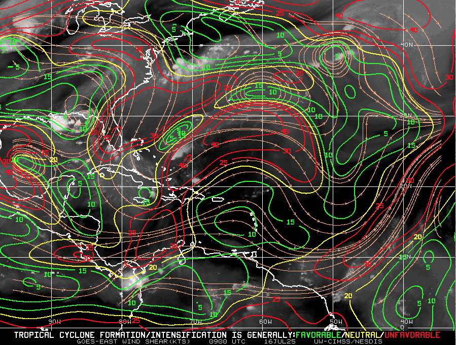
Wind Shear Courtesy of https://tropic.ssec.wisc.edu/
Wind Shear: Still elevated in the western Atlantic and Gulf, but beginning to weaken, particularly near Central America and the western Caribbean.
Moisture: Mid-level moisture continues to increase, especially in the Caribbean and southern Gulf.
Saharan Air Layer: A large, dry SAL continues to stretch across the central Atlantic, suppressing storm formation east of the Lesser Antilles, but it's expected to weaken by early August.
Relative Humidity (ECMWF) data courtesy of Windy.com
Saharan Air Layer (Dust) data courtesy of Windy.com
Thunderstorm & Rainfall Activity
Florida & Gulf Coast: Expect locally heavy rain and thunderstorm clusters tied to the Gulf disturbance.
Western Caribbean: Some disorganized convection continues, but nothing tropical at this time.
West Africa: A new tropical wave has emerged, but faces significant dry air and shear over the central Atlantic.
Rainfall forecast (ECMWF) courtesy of Windy.com
Florida Forecast
Highs: Upper 80s to low 90s°F
Humidity: High, with a heat index reaching the upper 90s
Rain: 60–70% chance of scattered storms in parts of Florida, especially in the afternoon and evening
Winds: Light southeast winds, with occasional gusts during storms
Prep Tip of the Day: Review Flood Insurance Coverage
Standard homeowners insurance does not cover flood damage. Use this calm window to:
Check your flood zone designation
Review your current policy limits
Confirm your coverage start date (flood insurance usually has a 30-day waiting period)
With warm SSTs and an increasingly favorable atmosphere, inland and coastal flood risk rises as we move deeper into hurricane season.
Looking Ahead: Watchful, Not Worrying
Although July 16 brings no immediate storm threats, all eyes remain on the broader Atlantic:
The ingredients for development are aligning: warm water, weakening shear, and increased moisture.
The next two weeks may see the first organized systems forming in the western Caribbean or Gulf of Mexico.
Now is the time to stay informed and finalize preparations—not when a storm is already on the map.