
Atlantic Hurricane Outlook – July 13, 2025: Tropics Quiet, Gulf Trough Under Watch
The Atlantic basin remains calm today, with no active named storms. However, meteorologists are tracking a low-pressure trough emerging off the Southeast U.S. coast, gradually drifting into the Gulf of Mexico. This system has a low (20%) chance of organizing into a subtropical or tropical system later this week .
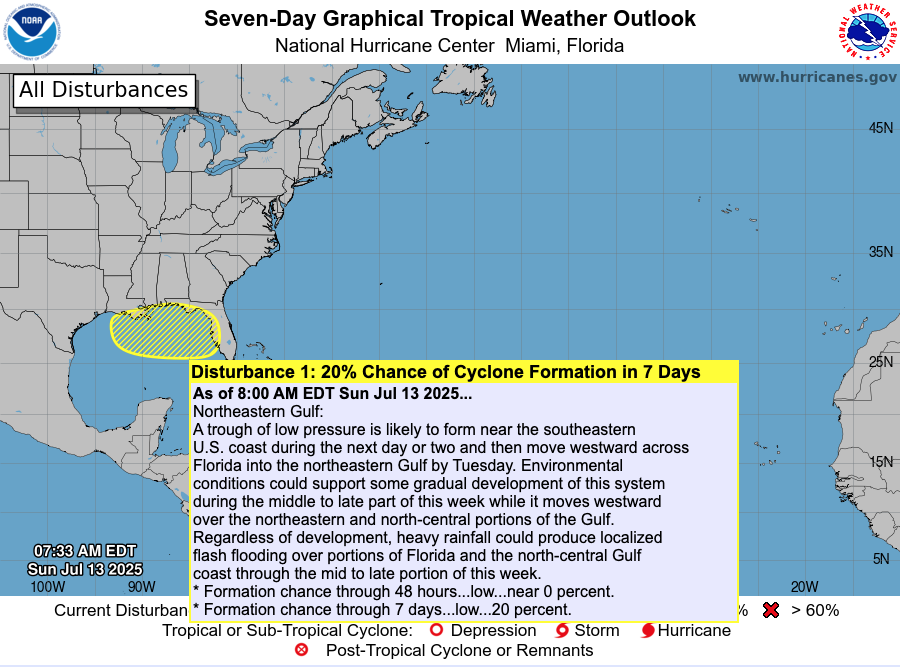
Atlantic Overview: Quiet But Evolving
As per the 8 AM EDT NHC Tropical Weather Outlook:
No active tropical cyclones across the basin.
The Southeast U.S. trough is expected to push into the Gulf by Tuesday.
Formation chances: <1% in next 48 hours, ~20% over 7 days .
Though not tropical now, its movement may increase rainfall and raise attention if organization begins.
Satellite view via Windy.com
Sea Surface Temperatures: A Warm Platform
The Gulf of Mexico continues to show SSTs 2–4°F above average, providing a warm environment for storm development later this season.
Caribbean and Main Development Region (MDR) SSTs also remain elevated, keeping hurricane fuel accessible .
Sea Surface Temperature via Windy.com
Atmospheric Setup: Suppression in Play

Wind Shear Courtesy of https://tropic.ssec.wisc.edu/
Wind shear remains moderately strong across much of the basin, hindering storm development.
Saharan dust is still prevailing over the eastern Atlantic, suppressing early-season storm growth.
Moisture levels are slowly increasing in the Gulf and Southeast U.S., signaling gradual support for convection.
Saharan Air Layer (Dust) via Windy.com
Regional Weather: Rain on the Rise
Expect increased showers and thunderstorms along the Southeast U.S. and Gulf coasts as the trough approaches.
Florida will likely see scattered afternoon storms, typical for July, especially as the trough draws moisture inland.
Thunderstorm Forecast (ECMWF) via Windy.com
Prep Tip of the Day: Be Rainwise
Even without strong winds, heavy rainfall can pose serious hazards:
Track the trough’s movement—it could bring localized flash flooding to Gulf coast areas.
Ensure storm drains and sump pumps are clear and functional.
Keep sandbags and quick barriers ready if you're in low-lying zones.
Test your NOAA Weather Radio and mobile alerts to stay ahead of rainfall warnings.
Looking Ahead: Waters Stay Warm—Storms Could Spark
Although the tropics are peaceful now, the combination of warm ocean temperatures, easing atmospheric inhibitors, and growing seasonal moisture suggest readiness for evolution. The trough may serve as the first spark of Gulf activity, with a watchful eye needed through mid- to late-week.
Stay alert and check back tomorrow for your latest update from Cat5Prep.com.