

Atlantic Hurricane Outlook – June 20, 2025: Tropics Hold Quiet as Atlantic Patterns Begin to Shift
The Atlantic remains calm with no storms expected, but warm waters and shifting atmospheric patterns hint that the quiet may not last. A developing Atlantic Niña could hit a reversal and amplify activity later this season.
As we close out the third week of the 2025 Atlantic hurricane season, the basin remains quiet. No named storms or tropical disturbances are being monitored by the National Hurricane Center (NHC), and no development is expected over the next 7 days. However, behind this calm lies a subtle shift in Atlantic patterns that may influence storm activity in the weeks ahead.
Atlantic Basin: All Clear—for Now
As of the latest NHC update (8 AM EDT, June 20):
No active tropical cyclones
No areas of interest
No tropical development expected through late June
This type of quiet is typical for mid-June, historically a transitional period before activity ramps up in July and peaks from August to October.
Satellite view via Windy.com
Sea Surface Temperatures: Still Hot, Still Fuel
Sea surface temperatures (SSTs) across much of the Atlantic remain well above normal:
Gulf of America (Mexico): Mid to upper 80s°F (29–31°C), 2–4°F above average
Western Caribbean: Similar anomalies, particularly near the Yucatán and Cuba
Main Development Region (MDR): Still warming gradually, trending toward conditions that could support long-track storms later this season
Warm SSTs are a critical energy source for hurricanes—and the heat is already in place.
Sea Surface Temperature (ECMWF Analysis) via Windy.com
Atmospheric Conditions: Neutral ENSO, but Atlantic Cooling Briefly
While the Pacific remains in an ENSO-neutral phase, a rare “Atlantic Niña” has recently emerged—marked by cooler-than-average sea surface temperatures in the eastern tropical Atlantic off the coast of Africa, as seen in the NOAA Coral Reef Watch chart below with a pocket of blue.
This can temporarily suppress early-season hurricane formation by reducing convection and stabilizing the atmosphere
However, models indicate that this pattern may reverse in July, shifting into a warmer Atlantic Niño phase, which typically boosts tropical activity
So, while the Atlantic Niña may be limiting development now, forecasters are closely watching the timing of this transition. Safe money would be on a reversal, which could super charge storm breeding.

Overall Scope of Sea Temperature Anomalies
Saharan Air Layer: Still Limiting Tropical Waves

Wind Shear Courtesy of https://tropic.ssec.wisc.edu/
A strong Saharan Air Layer (SAL) remains entrenched across the tropical Atlantic:
Dry, dusty air suppresses thunderstorm development
Increases stability and upper-level wind shear
Common in June, but typically weakens by mid-July
For now, SAL continues to act as a shield against organized tropical development in the Main Development Region.
Saharan Air Layer (Dust) data via Windy.com
Thunderstorm Activity: Mostly Seasonal and Local
While no tropical organization is underway, convection continues to pop up in key regions:
Florida and Gulf Coast: Afternoon storms due to heat and humidity
Western Caribbean: Scattered convection, but unorganized
Eastern Atlantic: A few tropical waves exiting Africa remain weak and embedded in dry air
These thunderstorms are typical for the season and do not currently show signs of tropical development.
Thunderstorm Forecast (ECMWF) via Windy.com
Florida Forecast
Highs: Upper 80s to low 90s°F (31–33°C)
Humidity: High
Afternoon Storms: Scattered area of thunderstorms likely after 2 PM
Winds: Light and variable, with storm gusts possible
Flooding in low-lying areas is possible if storms linger over one area.
Rainfall Forecast (ECMWF) via Windy.com
Prep Tip of the Day: Restock Pet Supplies
Don’t forget your furry family members when preparing for hurricane season:
Have a two-week supply of pet food, medications, and water
Keep vaccination records and vet contact info in your go-bag
Prepare a small pet first-aid kit
Label pet carriers clearly and store them where they’re easy to grab
Looking Ahead: Transition Coming
For now, the Atlantic basin is calm. But forecasters continue to watch:
Warm SSTs
Easing wind shear
Gradual return of moisture
Potential reversal from Atlantic Niña to Atlantic Niño
All signs point to a more active environment forming as we move into July. Stay alert, stay prepared, and check back tomorrow for your daily hurricane outlook from Cat5Prep.com.

Atlantic Hurricane Outlook – June 10, 2025: Quiet Continues, But Observers Stay Alert
No storms in sight, but sea surface temperatures continue to rise and wind shear is gradually easing—signs that the quiet start to the 2025 hurricane season may not last.
The tenth day of the 2025 Atlantic hurricane season opens with calm skies and no immediate threats. The latest update from the National Hurricane Center (NHC) confirms no active systems and no expected tropical cyclone formation over the next seven days. Early June often starts this way, but with sea surface temperatures climbing and atmospheric factors slowly shifting, vigilance remains important.
Atlantic Basin: No Systems in Sight
No active tropical cyclones
No areas of interest
No development anticipated within 7 days
This outlook aligns with the expected early-season lull, but conditions are steadily changing.
Satellite data courtesy of Windy.com
Sea Surface Temperatures: Warming Trend Continues
Gulf of Mexico & Western Caribbean: Still in the low to mid‑80s °F (around 27–29 °C), ideal for fueling storms when other factors permit
Main Development Region (MDR): Running warmer than average for early June—enough to support development later this month
These warm waters are critical as the season progresses.
Sea Surface Temperature data courtesy of Windy.com
Atmospheric Conditions: Mixed Signals
Wind Shear: Moderate to high across much of the basin, particularly within the western Caribbean and central Atlantic—limiting today’s storm potential
Moisture: Mid-level moisture appears to be on the rise, which could support future thunderstorm activity

Wind Shear Courtesy of https://tropic.ssec.wisc.edu/
Saharan Air Layer: A Dry Deterrent
A robust plume of Saharan dust continues to suppress tropical wave development across the eastern Atlantic and MDR
This dry layer is expected to ease by late June, removing one of the key early-season inhibitors
Saharan Air Layer data courtesy of Windy.com
Thunderstorm Activity: Routine, Not Tropical
Florida & Southeastern U.S.: Expect isolated afternoon storms typical for June
Western Caribbean: A few disorganized showers and storms—no rotation or organization evident
Atlantic Ocean: Quiet, with no tropical wave activity currently observed
Thunderstorm data courtesy of Windy.com
Florida Forecast (Statewide)
Highs: Upper 80s to low 90s °F (31–33 °C)
Humidity: Moderate to high—classic muggy comfort
Rain: Scattered afternoon/evening showers typical of early summer
Winds: Light and variable
Rain data courtesy of Windy.com
Prep Tip of the Day: Check Evacuation Zones
With time on your side:
Confirm your evacuation zone and review the planned evacuation route
Update your family emergency contact lists
Ensure your NOAA weather radio and mobile alert settings are active
Keep local emergency management contacts accessible
Looking Ahead: Still Quiet, But Watch for Change
While no tropical development is expected this week, underlying conditions are subtly shifting:
Warm ocean waters persist
Atmospheric wind shear is forecast to gradually decrease
Moisture levels are on the rise
Saharan dust is weakening, removing suppression barriers
Early hurricane season often starts quietly—but conditions can change fast. Stay tuned to Cat5Prep.com for daily updates.

Atlantic Hurricane Outlook – June 5, 2025: A Weak Low, a Wet Southeast, and a Watchful Eye
June 5 brings continued calm in the Atlantic, with no named storms and no areas of concern. But warm sea surface temperatures and slowly shifting atmospheric conditions suggest more activity may be on the way later this month.
The fifth day of the 2025 Atlantic hurricane season begins with calm skies and no tropical activity on the horizon. While this early June quiet is typical, forecasters are closely watching for subtle atmospheric shifts that may usher in increased activity later in the month. Now is the perfect time to double-check your emergency plans while the weather remains cooperative.
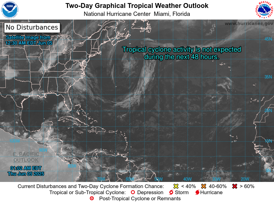
Atlantic Basin: No Immediate Concerns
As of the latest National Hurricane Center (NHC) update (8 PM EDT June 4 or the upcoming 2 AM EDT June 5 outlook):
No active tropical cyclones
No areas of interest under investigation
No development expected within the next 7 days
This quiet pattern aligns with the early season lull seen in most years before conditions ramp up later in June and July.
Satellite imagery courtesy of Windy.com
Sea Surface Temperatures: Warming Trend Continues
Ocean heat—an essential ingredient for tropical storm formation—is building across the Atlantic:
Gulf of America (Mexico): Widespread low to mid-80s°F (28–30°C), running above average
Western Caribbean: Seasonally warm, primed for potential development in coming weeks
Main Development Region (MDR): Temperatures are climbing faster than usual for early June, laying a foundation for future storms
Sea surface temperature data courtesy of Windy.com
Wind Shear & Moisture: Still Mixed, Slowly Improving
Atmospheric conditions aren’t yet fully supportive of tropical formation, but change is underway:
Wind Shear: Still moderate to high in the western Caribbean and central Atlantic—strong enough to disrupt organization. Long-range models show a gradual easing expected later in June
Moisture: Mid- and lower-atmosphere humidity is rising in the Gulf and Caribbean, hinting at increasing thunderstorm potential
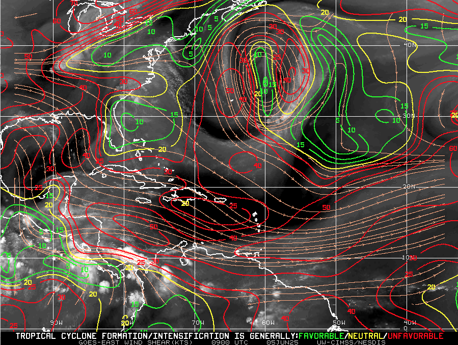
Wind Shear Courtesy of https://tropic.ssec.wisc.edu/
Saharan Air Layer: Strong, But Temporary Barrier
The Saharan Air Layer (SAL) remains a major suppressing force across the tropical Atlantic:
Dry, dusty air and associated wind shear prevent tropical waves from organizing
This layer is expected to weaken by mid-to-late June, removing a key obstacle to development
Saharan Air Layer data courtesy of Windy.com
Thunderstorm Activity: Typical Early Summer Patterns
No tropical cyclones—but thunderstorm activity continues in familiar places:
Florida: Scattered afternoon storms expected from daytime heating
Western Caribbean: Some disorganized convection is present but lacks structure
Off the U.S. East Coast: No significant organized convection at this time
Thunderstorm data courtesy of Windy.com
Florida Forecast – Early Summer Vibes Across the Peninsula
Expect a classic early summer day throughout Florida:
Highs: Upper 80s to low 90s°F (31–33°C) statewide
Humidity: Elevated levels bringing a muggy, tropical feel all day
Rain: Scattered afternoon thunderstorms likely, mostly brief and localized
Winds: Light and variable, with gentle breezes in many areas
Stay hydrated and be prepared for brief showers if you’re out and about this afternoon!
Radar data courtesy of Windy.com
Prep Tip of the Day: Verify Emergency Contact Information
Use this calm stretch to get communication-ready:
Update your family contact plan—make sure everyone knows who to call
Register for local emergency alerts via text or email
Bookmark vital sites like hurricanes.gov and Cat5Prep.com
Looking Ahead: Calm Now, But Stay Ready
No development is expected in the coming week—but the groundwork is being laid:
Warm waters across the basin
Easing wind shear on the horizon
Moisture and instability beginning to rise
The tropics may be quiet today, but the story of the 2025 hurricane season is just beginning. Stay informed, stay ready—and check back tomorrow for the next Cat5Prep.com update.