
Atlantic Hurricane Outlook – July 9, 2025: Calm Seas Persist Amid Seasonal Build
The Atlantic remains quiet today, with no active storms and no development expected. But record-warm waters and shifting atmospheric patterns suggest that tropical activity could ramp up soon.
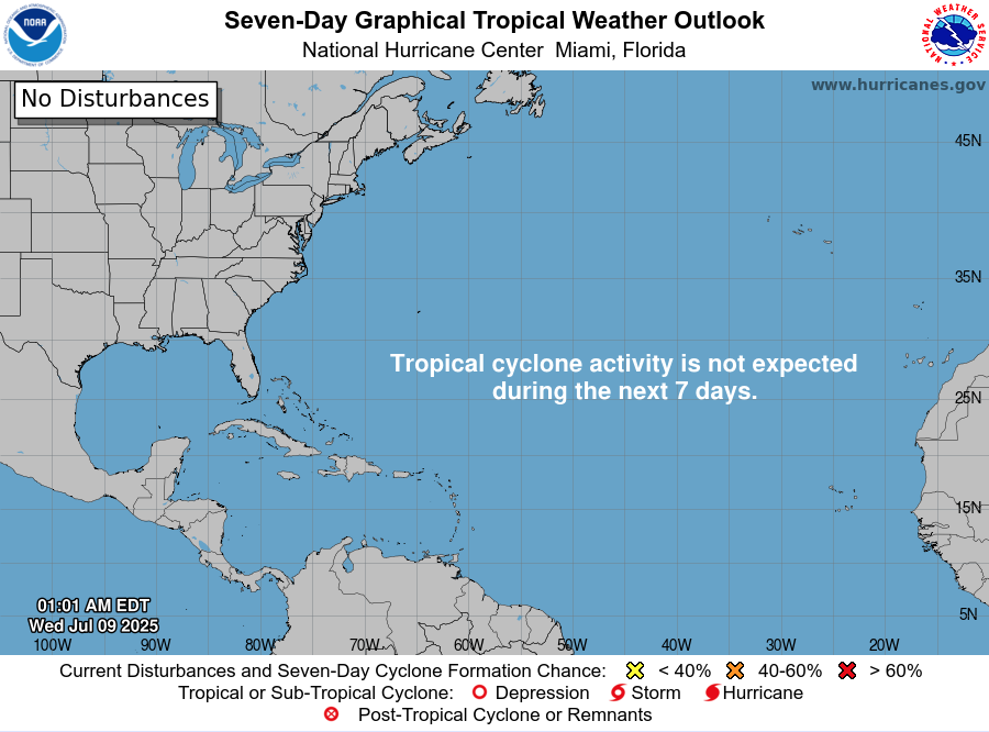
Mid-July typically signals more tropical activity—but today, the Atlantic remains unusually quiet. According to the latest NHC updates, no tropical cyclones are present, with no expected development over the next seven days. Despite the current calm, strong indicators suggest the season’s intensity is primed to rise.
Atlantic Basin: All Clear for Now
No active systems in the Atlantic, Caribbean, or Gulf
NHC forecast maintains zero development chances across the basin
This lull is rare for July and may end soon as heat and moisture build
Satellite view via Windy.com
Seasonal Outlook: Above-Normal Conditions Ahead
CSU’s July update continues to forecast an above-average season:
~17 named storms, including ~9 hurricanes and ~4 major hurricanes .NOAA similarly predicts 13–19 named storms, with a 60% chance of a busier-than-average season.
Sea Surface Temperatures: High Heat Levels
Atlantic SSTs remain well above normal—2–4°F above average—in the Gulf, Caribbean, and MDR
These elevated temperatures continue to provide plenty of energy for storm formation in the weeks ahead
Sea Surface Temperature via Windy.com
Atmospheric Conditions: Secondary Barriers Easing

Wind Shear Courtesy of https://tropic.ssec.wisc.edu/
Wind shear remains moderate-to-high, particularly in the eastern Atlantic—temporarily limiting development
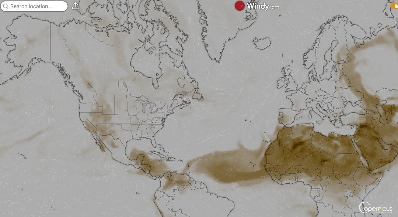
Saharan Air Layer (SAL) and occasional dry mid-level air still suppress convection but are expected to diminish
Moisture is steadily increasing, with abundant humidity projected across storm-prone regions
Saharan Air Layer (Dust) via Windy.com
What to Watch Next
Upcoming Infrared and visible satellite loops for signs of organization
Shifts in wind shear over the Gulf and Caribbean
Any African easterly waves gaining moisture and structure
Wind Gust Accumulation Forecast (ECMWF) via Windy.com
Early July Trends
Only one named storm (Chantal) has formed so far, but it remained weak and quickly dissipated
History shows many July systems originate in the Gulf, Caribbean, or off the Southeast U.S. coast
Outlook: Active Patterns Brewing
While quiet now, the combination of warm SSTs, moist air, and weakening shear/SAL signals a rising likelihood of Atlantic development
Hurricane Season Peak is still ahead—August through October—but increased vigilance is essential now
Prep Tip of the Day: Check Your Alert Systems
With the season expected to intensify:
Confirm NOAA Weather Radio is operational
Enable emergency alerts on all devices
Update your hurricane kit and evacuation plan
Bookmark Cat5Prep.com and the National Hurricane Center for future updates
The Atlantic remains calm—but the foundation for tropical activity is strengthening daily. Stay alert, stay prepared, and check back tomorrow for your next Cat5Prep.com outlook.

Atlantic Hurricane Outlook – May 29, 2025: A Calm Before the Storm?
As the 2025 Atlantic hurricane season nears, conditions are aligning for increased activity. Here's today's outlook and what it means for storm development.
As we approach the official start of the Atlantic hurricane season on June 1, the tropics are offering us a brief moment of calm. As of today, May 29, 2025, there are no active tropical systems in the Atlantic basin. The National Hurricane Center (NHC) reports no significant disturbances in the Atlantic Ocean, the Caribbean Sea, or the Gulf of Mexico. But behind this stillness lies a set of powerful climatic conditions primed to ignite what could be a very active hurricane season.

*Data Courtesy of National Hurricane Center
A Season Poised for Action
Earlier this month, the National Oceanic and Atmospheric Administration (NOAA) released its seasonal outlook, forecasting a 60% chance of an above-average hurricane season. According to their projections, the Atlantic could see:
13 to 19 named storms
6 to 10 hurricanes
3 to 5 major hurricanes (Category 3 or stronger)
These predictions are based on a confluence of environmental indicators—particularly warm sea surface temperatures, neutral ENSO conditions, and weakened trade winds—each contributing to a higher potential for tropical cyclone formation.
Sea Surface Temperatures: The Ocean’s Warning Signal
The ocean is one of the most powerful drivers of hurricane activity, and right now, it's sounding the alarm.

*Data Courtesy of NOAA
Record-Warm Waters in the Atlantic
The North Atlantic is currently experiencing its third-warmest May on record, with sea surface temperatures (SSTs) well above seasonal averages. The heat isn't limited to open waters either—the Gulf of Mexico and the Caribbean Sea are also running unusually warm, creating an extensive reservoir of potential hurricane fuel.
Warm SSTs are a critical component of storm development, providing the energy needed to sustain and intensify tropical systems. Water temperatures of 80°F (27°C) or higher are generally needed to support cyclogenesis, and many areas in the tropical Atlantic are already surpassing this threshold.
Marine Heatwave Near Florida
Perhaps more concerning is the marine heatwave stretching from Florida through the Bahamas and into the western Caribbean. These waters are seeing temperatures typical of mid-summer, not late May, a sign of the accelerating heat trend across global oceans.
This marine heat is already influencing regional weather patterns by:
Increasing humidity levels
Amplifying rainfall intensity
Fueling convective thunderstorms across the southeastern U.S.
These factors don’t directly spawn hurricanes—but they create a more volatile, moisture-rich environment in which tropical disturbances can evolve rapidly once they form.

*Data Courtesy of Coral Reef Watch —Data May Be Delayed
Saharan Dust: Nature’s Fire Extinguisher
While warm seas suggest heightened hurricane potential, one atmospheric feature is acting as a temporary barrier: Saharan dust.
Each year, dust from the Sahara Desert is swept across the Atlantic by strong easterly winds, forming what’s known as the Saharan Air Layer (SAL). This dry, dusty air mass stretches thousands of miles and can significantly inhibit storm development by:
Drying out the mid-level atmosphere
Suppressing cloud formation
Increasing vertical wind shear
This week, a new surge of Saharan dust is drifting over Florida, leading to hazy skies and lowered air quality across the peninsula. While visually striking—especially at sunrise and sunset—the presence of this dust is a temporary check on early-season storm activity.
Meteorologists expect the SAL to weaken in the coming weeks, especially as July and August approach. When that happens, the Atlantic will become more conducive to sustained storm development.
Saharan Dust Data Courtesy of Windy.com
Local Conditions: Florida's East and Gulf Coasts
While the tropics are currently calm, Florida isn’t escaping turbulent weather.
Today, the East and Gulf coasts of Florida are experiencing classic pre-summer instability:
High humidity levels are combining with daytime heating to create strong atmospheric lift
Afternoon thunderstorms are likely, particularly inland, with some storms potentially producing:
Hail
Damaging wind gusts
Frequent lightning
Temperatures are expected to peak in the low 90s (°F) with overnight lows in the low 70s, maintaining high dew points and muggy conditions. This type of weather is not directly related to hurricane activity, but it’s a reminder that the region is entering its most active weather period of the year.

Data Courtesy of Windy.com
Meteorological Factors Influencing the 2025 Season
Several broader climate factors are shaping the hurricane outlook for 2025. Let’s break them down:
ENSO-Neutral Conditions
The El Niño–Southern Oscillation (ENSO) is currently in a neutral phase, meaning neither El Niño (which suppresses Atlantic hurricanes) nor La Niña (which enhances them) is present.
This neutral backdrop means that other conditions—like SSTs, wind shear, and moisture availability—will have a stronger influence this year. Historically, ENSO-neutral years can swing either way, but combined with record-warm waters, the scales may tip toward higher activity.
Weakened Trade Winds
Forecast models show weaker-than-average trade winds over the Caribbean and tropical Atlantic. This is important because strong trade winds often blow potential storms apart before they can organize. In contrast, weaker winds allow storms to build vertically and tap into deep moisture columns—ideal conditions for hurricane formation and intensification.
Dust's Waning Influence
As mentioned earlier, the Saharan dust currently suppressing tropical activity is expected to decline as we head deeper into June and July. With fewer dust outbreaks and a moister atmosphere, the door will open wider for tropical waves emerging off Africa to develop into organized systems—particularly during the peak season from August to October.
Looking Ahead: Time to Prepare
Right now, the Atlantic might seem calm—but all indicators point to an explosive potential for storm activity in the months ahead. This quiet period is an ideal window for preparedness. Make sure to follow our Prep Blog for tips and equipment that are our go-to.
What You Should Do Now
Check your hurricane supply kits. Make sure they include essentials like non-perishable food, water, batteries, flashlights, medications, and pet supplies.
Review your evacuation plan. Know your route, your shelter options, and how to communicate with family members.
Stay informed. Set alerts from trusted sources like:
National Hurricane Center (www.nhc.noaa.gov)
Local weather apps and news stations
NOAA Weather Radio
Follow emerging tropical waves. Just because a storm hasn’t formed yet doesn’t mean the atmosphere isn’t building toward one.
Eyes on the Horizon
The 2025 Atlantic hurricane season may be starting slow, but the environmental backdrop suggests this quiet won’t last. Between record-warm waters, a neutral ENSO, weakening dust layers, and favorable wind conditions, we may be on the edge of one of the more active seasons in recent memory.
If you're in a hurricane-prone area, take today’s calm as a gift—and a warning. Use this time to prepare, stay vigilant, and be ready for whatever the skies may bring in the weeks ahead.