
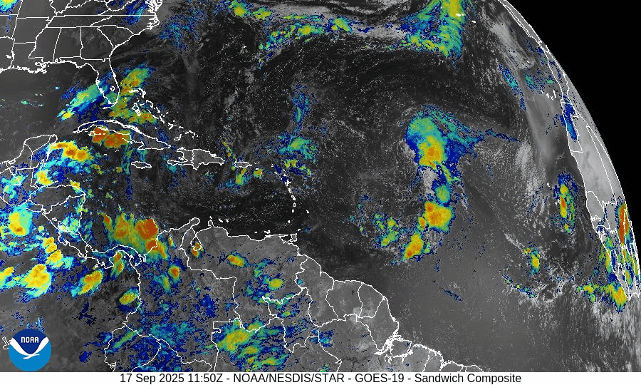
Atlantic Hurricane Outlook – September 22, 2025
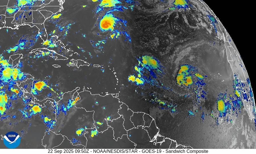
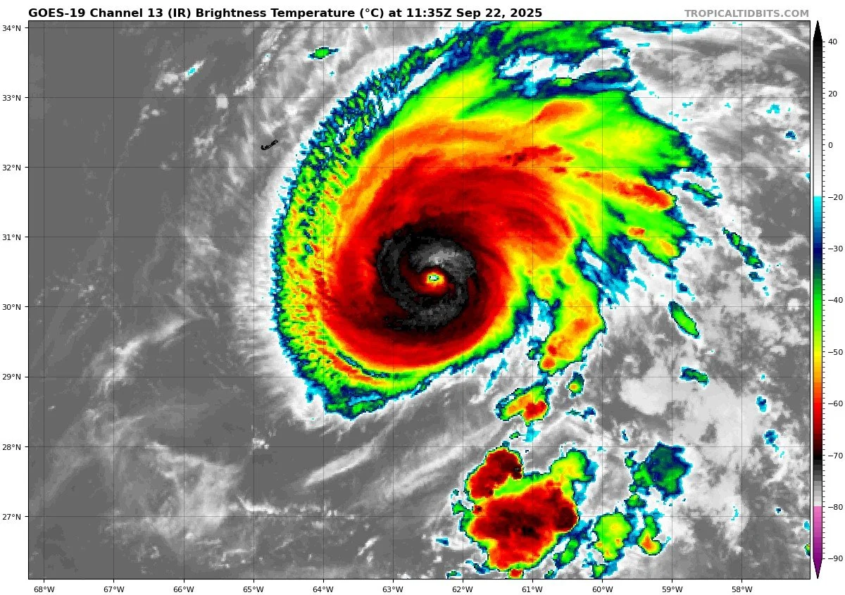
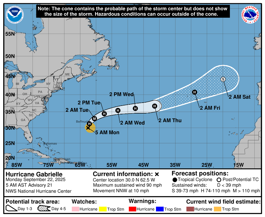
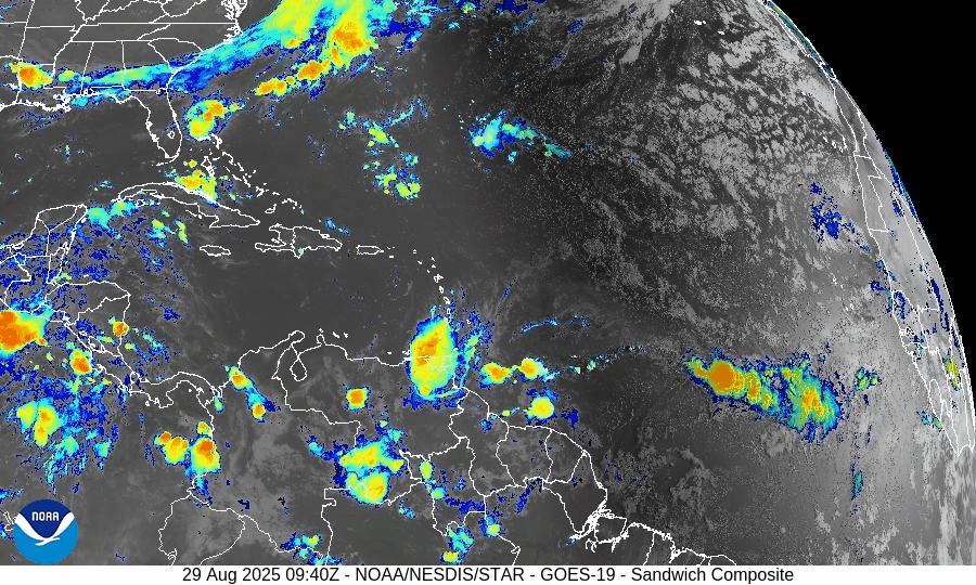
On September 22, Hurricane Gabrielle is active in the central Atlantic as a Category 1 storm with sustained winds near 90 mph. The storm is forecast to pass east of Bermuda, producing no direct land impacts but generating strong swells and rip currents. Two additional tropical waves are being monitored, with one given a 60% chance of development over the next week. Florida and the Gulf of America remain calm, experiencing only routine late-summer thunderstorms.

Hurricane Gabrielle strengthens; two additional waves being monitored
Atlantic Basin Overview
Hurricane Gabrielle
Gabrielle has intensified into a Category 1 hurricane, currently located southeast of Bermuda. Sustained winds are near 90 mph, and the storm is moving north-northwest at about 10 mph. Forecasts suggest further strengthening is possible over the next day or two. On its current track, Gabrielle is expected to pass east of Bermuda, with no direct landfall threat at this time.


Other Tropical Waves / Disturbances
The National Hurricane Center is monitoring two tropical waves across the Atlantic. One has a 60% chance of development over the next 7 days. Current model guidance suggests both systems are likely to stay over open waters or curve northward before approaching the Eastern U.S. coastline, including Florida, the Carolinas, and the Mid-Atlantic.
At this stage, no direct impacts are expected along the Eastern Seaboard, though stronger swells could increase rip current risks later in the week.
Environmental Conditions
Sea Surface Temperatures (SSTs): SSTs in the central to western tropical Atlantic remain warm—sufficient to support further strengthening of Gabrielle.
Wind Shear: Wind shear and dry air (including influence from the Saharan Air Layer) are suppressing organization in some quadrants of Gabrielle, slowing structural improvement.
Eastern Waves: The waves being monitored farther east are in less favorable environments currently—strong shear, dry air, and reduced moisture are limiting immediate development.
Gulf of America & Caribbean
The Gulf of America and Caribbean remain calm. High pressure dominates, producing only scattered afternoon thunderstorms. No organized tropical development is expected in these regions.
Florida & Eastern U.S. Forecast
Florida and the broader Eastern U.S. coastline remain outside of any direct tropical threats from Gabrielle or the monitored waves. Expect late-September conditions: warm, humid, with scattered afternoon thunderstorms. Swells from Gabrielle could enhance surf and rip current risks along parts of the East Coast later this week.
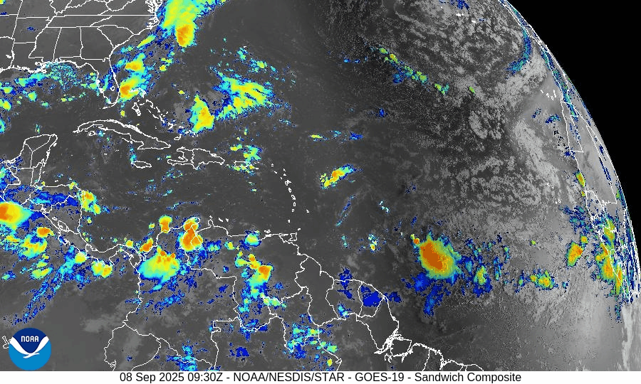
Rain forecast visualization courtesy of Windy.com

Summary
Gabrielle is now a Category 1 hurricane, strengthening in the central Atlantic, forecast to pass east of Bermuda.
Two tropical waves have been flagged; one has 60% development odds over 7 days, though no U.S. impacts are expected at this time.
Environmental factors favor Gabrielle’s gradual strengthening but suppress development of the eastern waves.
Gulf of America, Florida, and the Eastern Seaboard remain calm, with no direct tropical threats currently.
TL;DR – September 22 Snapshot
Hurricane Gabrielle is a Category 1, staying offshore and east of Bermuda.
Two waves being monitored; one with 60% odds, no U.S. threat expected.
Warm SSTs support Gabrielle; wind shear, dry air, and SAL limit other development.
Florida and the Eastern U.S. coast remain safe for now, aside from potential rip current risks.

Atlantic Hurricane Outlook – September 18, 2025
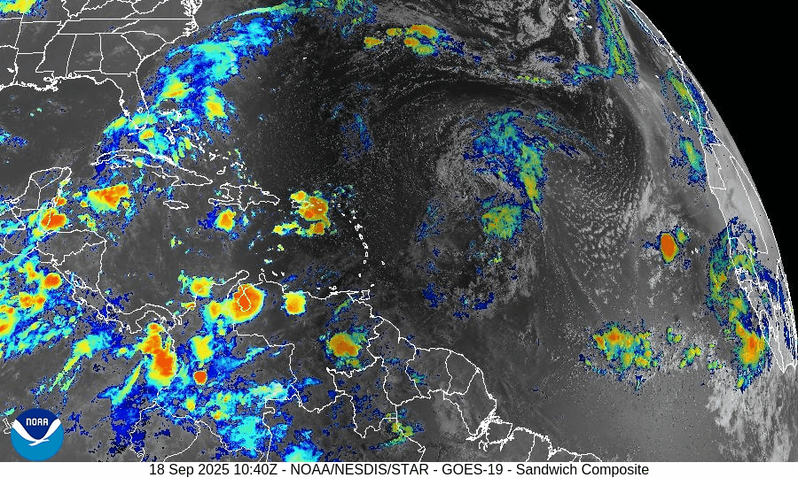
On September 18, Tropical Storm Gabrielle is active in the central Atlantic with maximum sustained winds near 50 mph. Wind shear and dry Saharan air are slowing its development, though gradual strengthening is possible this weekend as conditions improve. A separate tropical wave off Africa has only a low chance of development. Florida and the Gulf of America remain calm with only typical heat, humidity, and scattered afternoon thunderstorms.

Tropical Storm Gabrielle holds offshore; slowly strengthening amid environmental challenges
Atlantic Basin Overview
Tropical Storm Gabrielle
Gabrielle has formed well east of any major landmasses. As of the latest advisory, it’s located about 20.0°N, 50.3°W, moving west-northwest at roughly 15 mph, with maximum sustained winds around 50 mph and a minimum central pressure near 1004 mb. There are no watches or warnings for land at this time.Forecasters expect little change in its strength over the next 1-2 days due to wind shear and dry air interfering with its circulation. Some gradual intensification is possible late this weekend or early next week, especially as it moves into a more favorable environment.
Other Disturbances / Tropical Waves
A tropical wave is expected to move off the west coast of Africa soon; models give it a low chance (near 0%) of development in the next 48 hours, rising to about 20% over 7 days as it tracks west-northwest across the eastern and central tropical Atlantic.
Environmental Conditions
Sea Surface Temperatures (SSTs): SSTs along Gabrielle’s current path are warm enough to support gradual intensification, but they’ll need to remain favorable as it moves northwest.
Wind Shear: Elevated vertical wind shear is affecting Gabrielle now and is expected to suppress rapid strengthening during the next 24-48 hours. Conditions may improve somewhat later, permitting gradual organization.
Dry Air & Saharan Dust: Dry air and Saharan Air Layer (SAL) intrusions continue to disrupt convection, especially on the western side of Gabrielle. These factors are contributing to its somewhat ragged structure.
Gulf of America & Caribbean
The Gulf of America and Caribbean remain quiet with no tropical disturbances showing organization. Weather across these regions continues to be dominated by standard late-summer patterns: heat, humidity, and scattered afternoon showers.
Florida & Southeast U.S. Forecast
Florida remains outside of any immediate tropical threat. Expect typical mid-September conditions: hot, humid, with scattered afternoon thunderstorms. Gabrielle is forecast to remain over open water—no direct impacts expected for Florida or the U.S. coasts currently.
Rain forecast visualization courtesy of Windy.com

Summary
Gabrielle is now a named storm, tracking W-NW, far from land but being watched.
Environmental factors (wind shear, dry air) are inhibiting rapid intensification, though gradual strengthening is possible later.
No other systems currently threaten.
TL;DR – September 18 Snapshot
Tropical Storm Gabrielle is active, but staying offshore with no land threats.
Slow strengthening expected this weekend, if Gabrielle can overcome shear and dry air.
A wave off Africa has low short-term chances, modest 7-day potential.
Florida and Gulf of America remain calm.

Atlantic Hurricane Outlook – September 17, 2025
On September 17, Tropical Depression Seven formed in the central Atlantic and is expected to strengthen into Tropical Storm Gabrielle within 24 hours. A separate wave near the Cabo Verde Islands shows little immediate development potential due to dry air and Saharan dust. Warm waters and easing wind shear support further organization of the depression. Florida and the Gulf of America remain calm, with only typical late-summer heat, humidity, and scattered storms.

Tropical Depression Seven has formed; slow strengthening expected; Atlantic otherwise quiet
Atlantic Basin Overview
Tropical Depression Seven (formerly Invest 92L)
A new tropical system, now Tropical Depression Seven, has formed in the central tropical Atlantic. It is currently located near 13.7°N, 45.9°W, moving west at about 13 mph, with maximum sustained winds of 35 mph and a central pressure of around 1007 mb. It could strengthen into Tropical Storm Gabrielle by Wednesday afternoon or evening, according to the National Hurricane Center.Tropical Wave East-Southeast of the Cabo Verde Islands
There is also a tropical wave producing disorganized showers and thunderstorms east-southeast of the Cabo Verde Islands. Environmental conditions are only marginally favorable, so any development is expected to be slow as it moves westward at 15-20 mph.
Environmental Conditions
Sea Surface Temperatures (SSTs): Warm enough in the tropical Atlantic to support further strengthening of the depression.
Wind Shear: Moderate shear currently limiting rapid intensification, but shear is forecast to ease somewhat in the path of Tropical Depression Seven.
Dry Air & Saharan Air Layer (SAL): Dry mid-level air and dust from the Saharan Air Layer remain present over portions of the eastern Atlantic. These are expected to affect the wave near Cabo Verde more than the depression.
Gulf of America (Mexico) & Caribbean
The Gulf and Caribbean remain quiet, with no tropical disturbances showing signs of organization. Weather in these areas continues to be typical for mid-September: heat, humidity, and scattered thunderstorms.
Florida & Southeast U.S. Forecast
Florida continues under its usual early-fall pattern: hot, humid, with afternoon thunderstorms. As of now, no tropical threat to Florida is indicated from Tropical Depression Seven or the eastern Atlantic wave. Coastal conditions are stable.
Rain forecast visualization courtesy of Windy.com

Summary
Tropical Depression Seven is now active and likely to become Tropical Storm Gabrielle soon.
The wave near Cabo Verde is being watched but development will be slow and is less likely in the near term.
Environmental conditions are mixed: SSTs favorable; shear and dry air remain suppressing factors.
Gulf, Caribbean, Florida remain calm with routine summer weather and no tropical risks at this moment.
TL;DR – September 17 Snapshot
Tropical Depression Seven has formed and may become Gabrielle by Wednesday.
Another weak tropical wave is being monitored but poses no imminent threat.
Dry air, SAL, and shear are still important suppressors.
Florida / Gulf of Mexico remain clear of tropical risk for now.
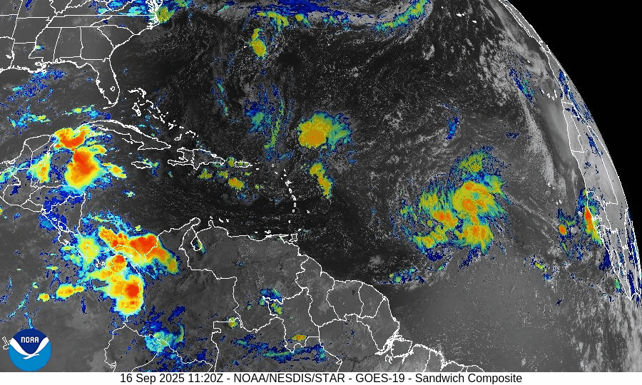
Atlantic Hurricane Outlook – September 16, 2025
On September 16, Invest 92L in the central Atlantic continues to organize and has a 90% chance of becoming a tropical depression or Tropical Storm Gabrielle in the next 48 hours. Another tropical wave is emerging off Africa with a lower 20% chance of development over 7 days. While warm waters and reduced wind shear support 92L’s growth, dry air and Saharan dust continue to hinder the African wave. Florida and the Gulf remain calm with only typical late-summer storms.
Invest 92L likely to become Tropical Storm Gabrielle; new wave off Africa also being monitored
Atlantic Basin Overview
Invest 92L
A broad area of low pressure known as Invest 92L—located about midway between the Windward Islands and the coast of West Africa—is showing increasing organization. The National Hurricane Center indicates high odds (≈ 90%) of formation into a tropical depression or tropical storm within the next 48 hours and similarly high odds over a 7-day outlook. Forecasts suggest it will move west-northwest or northwest at 10-15 mph. If named, it will be called Gabrielle.New Tropical Wave Off Africa
Another tropical wave is emerging off the western coast of Africa. It has lower odds of development—roughly 20% over 7 days, and near zero in the next 48 hours. It is moving westward toward the central Atlantic, where conditions could improve for gradual organization.
Environmental Conditions
Sea Surface Temperatures (SSTs): SSTs remain warm in the central to western tropical Atlantic, supportive of tropical storm development for disturbances like Invest 92L.
Wind Shear: The upper-level wind shear is decreasing in regions around Invest 92L, aiding its organization. However, moderate shear still exists in other parts of the basin, especially for newer waves emerging off Africa.
Dry Air & Saharan Air Layer (SAL): Dry air and dust from the Saharan Air Layer remain present in parts of the eastern Atlantic, which is damping convection in the newer wave. For Invest 92L, moisture levels are improving, helping its organizational efforts.
Gulf of America (Mexico) & Caribbean
The Gulf of Mexico and Caribbean remain mostly quiet. High pressure dominates, and while afternoon thunderstorms remain routine, no tropical development is expected in these regions in the near term.
Florida & Southeast U.S. Forecast
Florida is under its normal mid-September weather pattern—hot, humid, with scattered afternoon storms. There is no immediate tropical threat to Florida from Invest 92L or the wave off Africa at this time, though residents should monitor forecasts in case the track changes.
Rain forecast visualization courtesy of Windy.com

Summary
Invest 92L is very likely to become Tropical Storm Gabrielle imminently, with high chances over the next 1-2 days.
A new wave off Africa has low development odds now but could gain strength later in the week.
Environmental factors (warm SSTs, easing shear, improving moisture) favor development of Invest 92L, though SAL and dry air still affect newer disturbances.
Gulf, Caribbean, and Florida remain calm with only routine summer weather expected.
TL;DR – September 16 Snapshot
Invest 92L expected to form soon (likely Tropical Storm Gabrielle) with ~90% odds.
New wave off Africa has modest (~20%) 7-day potential.
Conditions are increasingly favorable around Invest 92L.
No tropical threats to Florida or the U.S. currently; routine summer storms only.

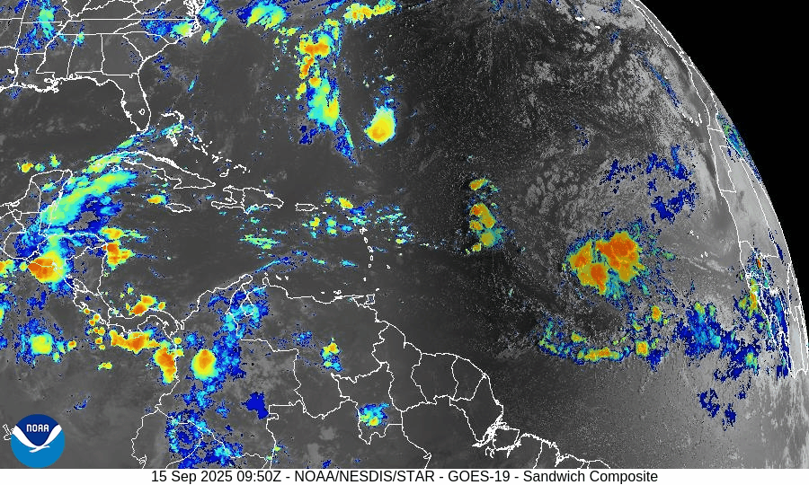
Atlantic Hurricane Outlook – September 15, 2025
On September 15, the Atlantic remains without active storms, but attention is on a tropical wave in the central Atlantic. The National Hurricane Center gives it a 30% chance of development in 48 hours and 80% over 7 days. Warm waters and easing wind shear may support gradual organization, while dry air and Saharan dust continue to limit rapid strengthening. Florida and the Gulf remain calm, with only routine heat, humidity, and scattered thunderstorms.

Quiet Atlantic continues; a tropical wave off western Africa showing high 7-day development potential
Atlantic Basin Overview
No Active Tropical Cyclones
The Atlantic, Gulf of Mexico, and Caribbean remain storm-free. The National Hurricane Center confirms there are no tropical storms or hurricanes currently active.Tropical Wave in the Central Tropical Atlantic
A tropical wave located in the central tropical Atlantic is producing a large area of disorganized showers and thunderstorms. It is moving west-northwest at 10-15 mph, and environmental conditions are expected to permit gradual development through the week. Formation chances are about 30% over the next 48 hours, increasing to 80% over the next 7 days.
Environmental Conditions
Sea Surface Temperatures (SSTs): SSTs in the tropical Atlantic remain warm enough to support storm formation.
Wind Shear: Moderate shear is present; while it may hinder rapid intensification early on, shear is expected to diminish somewhat near the wave’s path.
Dry Air & Saharan Air Layer (SAL): Dry air and some SAL/ dust intrusions are observed over parts of the eastern Atlantic. These will likely slow initial development but are not expected to completely prevent it as moisture pickup increases.
Gulf of America (Mexico) & Caribbean
The Gulf remains quiet under high pressure. Only routine afternoon and marginal overnight thunderstorms are forecast along coastal zones. No systems are showing organization or threat. Seas are generally modest.
Florida & Southeast U.S. Forecast
Florida is continuing its typical mid-September pattern: hot, humid, with scattered afternoon storms driven by sea breezes. With no tropical systems nearby, there are no tropical threats expected this week. Marine conditions are moderate and normal for this time of year.
Rain forecast visualization courtesy of Windy.com

Summary
The Atlantic remains calm with no active storms.
A tropical wave in the central Atlantic shows high potential (80% over 7 days) to develop, possibly forming a depression by week’s end.
Environmental factors (warm SSTs, reducing shear, some dry air) are mixed—some favorable, some limiting.
Gulf, Caribbean, Florida remain quiet with routine weather patterns.
TL;DR – September 15 Snapshot
Atlantic is quiet; no active systems.
The central tropical Atlantic wave has ~80% 7-day development odds.
Conditions are marginal but becoming more favorable near the wave.
Florida/Gulf remains calm with only the usual summer storms.

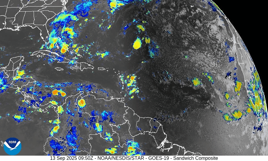
Atlantic Hurricane Outlook – September 13, 2025
On September 13, the Atlantic basin remains storm-free, with no tropical cyclones currently active. A tropical wave between Africa and the Cabo Verde Islands is producing showers and thunderstorms but faces limited short-term development potential due to dry air and wind shear. The Gulf of Mexico and Florida remain calm, experiencing only the usual heat, humidity, and afternoon storms of late summer.

Atlantic basin quiet; tropical wave off Africa flagged, but development odds remain modest
Atlantic Basin Overview
No Active Tropical Cyclones
There are currently no tropical storms, hurricanes, or depressions in the Atlantic, Gulf of Mexico, or Caribbean. The NHC confirms the basin is calm with no active systems.Tropical Wave Near Africa / Cabo Verde Islands
A tropical wave located between the west coast of Africa and the Cabo Verde Islands is producing some showers and thunderstorms. It’s being monitored. Environmental conditions (dry, stable air) are expected to limit development over the next few days, though a tropical depression could form by the middle to latter part of next week, moving west-northwestward at ~10-15 mph.
Environmental Conditions
Sea Surface Temperatures (SSTs): Warm in the Caribbean and Gulf (~29–31 °C), but the far eastern Atlantic faces somewhat cooler and less supportive SSTs for strong development.
Wind Shear: Moderate to strong upper-level wind shear persists, especially over the regions east of the tropical wave, making rapid intensification unlikely.
Dry Air & Saharan Air Layer (SAL): Significant dry and stable air, partly from the SAL, remains present over much of the eastern and central Atlantic — this is suppressing convective organization in the tropical wave.
Gulf of (America) Mexico & Caribbean
Both regions remain calm under high pressure. Only typical afternoon sea-breeze thunderstorms are occurring. There are no disturbances showing signs of organization in the Gulf or Caribbean.
Florida & Southeast U.S. Forecast
Florida continues with late-summer conditions: hot, humid, with scattered afternoon showers and thunderstorms. With no nearby tropical systems, there are no tropical threats or enhanced coastal risks at this time. Marine conditions are benign.
Rain forecast visualization courtesy of Windy.com

Summary
Atlantic basin remains inactive; no active systems.
A tropical wave off Africa is being monitored; development is possible later in the week but odds are modest and hindered by dry air and shear.
Environmental conditions are generally unfavorable for strong or rapid development in the near term.
Gulf, Caribbean, and Florida see only routine seasonal weather—no tropical threats.
TL;DR – September 13 Snapshot
Atlantic quiet—no storms active.
Tropical wave near Africa has potential but low short-term chances.
Dry air, SAL, and shear continue to suppress activity.
Florida & Gulf remain calm, with typical heat and scattered storms.

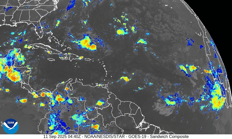
Atlantic Hurricane Outlook – September 11, 2025
On September 11, the Atlantic basin remains storm-free with no active cyclones. A tropical wave emerging off the coast of Africa has been given a 30% chance of development over the next 7 days, though environmental conditions such as wind shear, dry air, and Saharan dust remain unfavorable. The Gulf of Mexico and Florida stay calm, experiencing only typical late-summer thunderstorms.

Atlantic remains calm; weak tropical wave off Africa flagged with low chance (30%) of development over 7 days
Atlantic Basin Overview
No Active Tropical Cyclones
The Atlantic basin, including the Caribbean Sea and Gulf of Mexico, currently has no active tropical storms, hurricanes, or depressions. The NHC outlook confirms no formation expected in the near term.Tropical Wave Off Africa
A tropical wave is forecast to emerge offshore of West Africa by Friday. It will travel west to west-northwest at about 15 mph, over the eastern and central tropical Atlantic. Although conditions may allow for some gradual development, the NHC gives this wave a low chance (near 0%) over the next 48 hours, increasing to 30% over the next 7 days.
Environmental Conditions
Sea Surface Temperatures (SSTs): Warm in the Gulf and Caribbean (29–31 °C), supportive for storm formation there—but in the eastern tropical Atlantic, SSTs are marginal or just adequate for potential development.
Wind Shear: Moderate to high shear persists across much of the Atlantic, making rapid development unlikely.
Dry Air & Saharan Air Layer (SAL): Dry mid-level air and SAL remain strong headwinds for storm formation, especially for any tropical waves nearing the eastern Atlantic.
Gulf of America (Mexico) & Caribbean
Conditions remain quiet and stable. Only routine afternoon thunderstorms are expected along coastal areas, with no tropical system showing signs of organization.
Florida & Southeast U.S. Forecast
Florida continues in its typical early-September weather pattern—hot, humid, and marked by scattered afternoon thunderstorms. With no active systems in the Atlantic, Gulf, or nearby, there are no coastal or tropical threats expected in the short term. Surf and marine conditions are generally benign.
Rain forecast visualization courtesy of Windy.com

Summary
Atlantic is quiet with no active tropical storms.
Weak tropical wave off Africa has ~30% chance of development in 7 days; 0% in the next 48 hours.
Environmental factors (SSTs, shear, dry air/SAL) remain mostly unfavorable.
Gulf and Florida remain calm with routine summer convection.
TL;DR – September 11 Snapshot
No active storms in the Atlantic.
Wave off Africa has low but nonzero chance (30%) of forming in the coming days.
Hostile environment limits quick growth.
Florida and Gulf: quiet, typical late-summer weather.

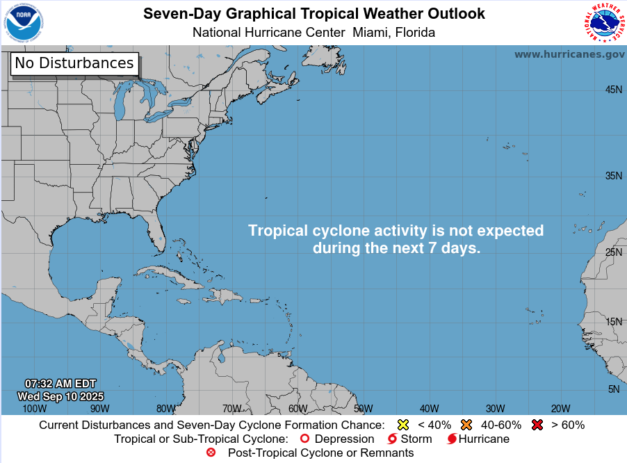
Atlantic Hurricane Outlook – September 10, 2025
On September 10, the Atlantic basin remains calm despite being the statistical peak of hurricane season. No tropical cyclones are active, and the National Hurricane Center does not expect development over the next week. Dry air, Saharan dust, and wind shear are keeping conditions hostile to storm formation. Florida and the Gulf of Mexico remain quiet, with only the typical late-summer pattern of heat, humidity, and afternoon thunderstorms.

Atlantic remains exceptionally calm during climatological peak; no tropical development expected
Atlantic Basin Overview
No Active Systems
Despite reaching the climatological peak of hurricane season (September 10), the Atlantic basin remains completely quiet—no tropical depressions, storms, or hurricanes are present. The National Hurricane Center’s 7-day outlook again shows no expected development.
The season's accumulated cyclone energy (ACE) across the Northern Hemisphere is currently below 60% of average, further emphasizing the unusual lull.
Last week’s disturbance—once showing high development potential near the Caribbean—dissipated after ingesting dry, dusty air from the Sahara.
Environmental Conditions
Sea Surface Temperatures (SSTs): Subtropics indicate record-warm SSTs, while much of the tropical Atlantic remains cooler than last year, reducing atmospheric instability and suppressing storm formation.
Atmospheric Conditions: Saharan dust plumes and a notably weak lapse rate in the atmosphere continue to inhibit convective development across the basin.
Looking Ahead: Meteorologists anticipate that activity may increase from late September into October. This is driven by the expected arrival of the Madden-Julian Oscillation (MJO) and continuing La Niña trends, both of which tend to support tropical cyclone development.
Gulf of Mexico & Caribbean
No tropical threats are present. High-pressure dominance continues to maintain calm conditions, aside from normal afternoon sea-breeze thunderstorms.
Florida & Southeast U.S. Forecast
Florida remains in its typical late-summer pattern: hot, humid, with scattered afternoon storms. With no tropical systems in the Atlantic or Gulf, no coastal or tropical hazards are expected this week.
Rain forecast visualization courtesy of Windy.com

Summary
The Atlantic basin is quiet, with no storms active or expected over the next 7 days.
Suppressive factors—cooler SSTs, dry air, Saharan dust, and weak atmospheric instability—continue to dominate.
Although conditions are currently unfavorable, model and observational insights suggest a potential pickup in tropical activity later this month as MJO and La Niña factors emerge.
Gulf and Florida remain unaffected, encountering only routine late-summer weather.
TL;DR – September 10 Snapshot
No activity in the Atlantic—still quiet at hurricane season peak.
Atmospheric conditions strongly suppress development: dry air, dust, and cool SSTs.
Climatology points to a possible uptick in activity toward late September/October.
Florida and the Gulf stay quiet—just the usual stormy afternoons.

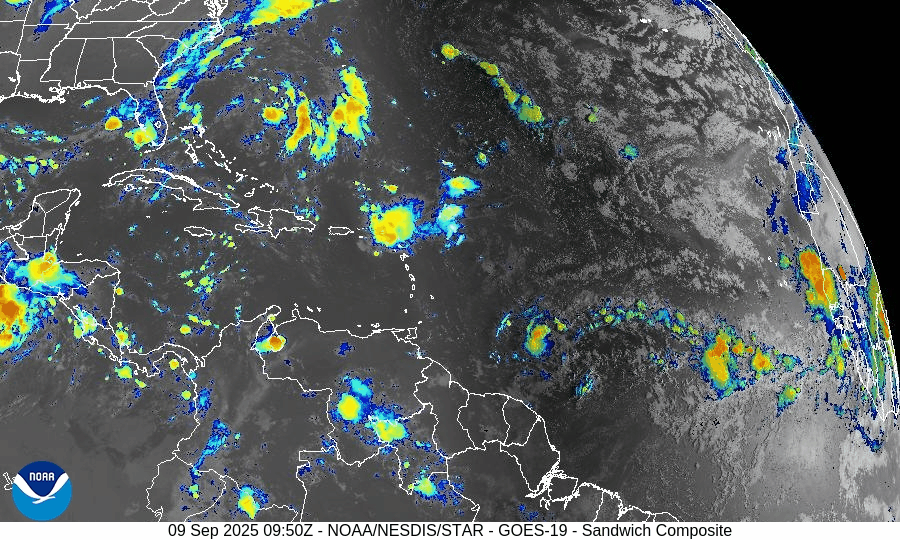
Atlantic Hurricane Outlook – September 9, 2025

TLDR Version: Click Here
Atlantic remains unusually quiet during peak season; no tropical development expected
Atlantic Basin Overview
No Active Storms
The Atlantic basin continues to be completely quiet. The National Hurricane Center’s latest outlook indicates no tropical cyclone formation is expected in the next 7 days.Tropical Waves
Although a few tropical waves are present, none show signs of sustained convection or development, remaining inactive across the Atlantic. This is stark, given we're in what is normally the most active week of the season.
Environmental Conditions
Sea Surface Temperatures (SSTs): Warm in the Gulf and Caribbean (~29–31 °C), but less conducive further east.
Wind Shear: Elevated shear across the basin continues to suppress tropical formation.
Dry Air & SAL: Persistent dry air and Saharan dust remain widespread, further choking off storm development.
Gulf of Mexico & Caribbean
Conditions remain stable and calm. Only typical afternoon sea-breeze thunderstorms are present along coastal areas. No tropical systems are forecast.
Florida & Southeast U.S. Forecast
Florida continues in its late-summer pattern: hot, humid, with scattered afternoon thunderstorms. With no systems nearby and improving surf conditions, there are no coastal or tropical threats expected this week.

Summary
The Atlantic is fully quiet with no active storms or development expected.
This is unusual for the second week of September, historically known as the Hurricane Season peak.
Environmental conditions remain unfavorable for storm formation: wind shear, dry air, and SAL dominate.
Gulf and Florida remain calm, experiencing only routine weather patterns.
TL;DR – September 9 Snapshot
No storms or development expected; Atlantic remains at rest.
Tropical waves are inactive amid unfavorable conditions.
Environmental factors continue to suppress activity.
Florida and the Gulf stay consistent with typical late-summer weather.
Atlantic Hurricane Outlook – September 8, 2025
On September 8, the Atlantic remains storm-free with no tropical systems active. Two weak tropical waves are producing scattered showers but lack organization, and the National Hurricane Center expects no development over the next week. Florida and the Gulf of Mexico remain calm, experiencing only the usual late-summer heat, humidity, and afternoon thunderstorms.

TLDR Version: Click Here
Atlantic basin remains calm — no tropical development expected this week
Atlantic Basin Overview
No Active Systems
The Atlantic, Caribbean, and Gulf of America (Mexico) remain free of tropical cyclones. The National Hurricane Center does not expect any development over the next 7 days.
Tropical Waves Present but Inactive
A wave near 20°W, east of the Cabo Verde Islands, is producing scattered showers but is not expected to organize.
Another wave between 41°W and 47°W in the central Atlantic shows some convection but remains disorganized.
Environmental Conditions
Sea Surface Temperatures (SSTs): Warm in the Gulf and Caribbean (~29–31 °C), but cooler in the open Atlantic, limiting storm growth.
Wind Shear: Moderate to strong across much of the basin, unfavorable for storm organization.
Dry Air & SAL: The Saharan Air Layer and widespread dry mid-level air continue to suppress deep convection and tropical development.
Gulf of America (Mexico) & Caribbean
The Gulf remains quiet and stable, with only routine afternoon sea-breeze thunderstorms. No tropical development is expected.
Florida & Southeast U.S. Forecast
Florida stays in its late-summer pattern of heat, humidity, and scattered afternoon thunderstorms. No tropical threats are present this week.
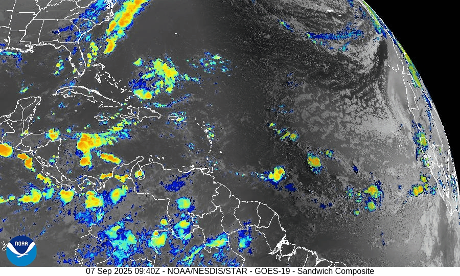
Rain forecast visualization courtesy of Windy.com

Summary
The Atlantic is inactive, with no storms or new development expected.
Two tropical waves are noted, but neither shows potential for near-term organization.
Environmental conditions remain unfavorable across the basin, with shear, dry air, and SAL dominating.
The Gulf and Florida remain calm, with only routine late-summer weather.
TL;DR – September 8 Snapshot
No storms in the Atlantic.
A couple of weak tropical waves, but no organization.
Shear, dry air, and SAL continue to suppress development.
Gulf and Florida remain quiet with typical afternoon thunderstorms.

Atlantic Hurricane Outlook – September 7, 2025
On September 7, the Atlantic remains completely calm with no tropical storms or hurricanes. The National Hurricane Center expects no development over the next 7 days. A weak tropical wave in the central Atlantic is producing scattered showers but shows no signs of organization. Florida and the Gulf of Mexico remain quiet, experiencing only typical late-summer thunderstorms.
**We’re back after a series of technical issues. We apologize for the inconvenience.
TLDR Version: Click Here
Atlantic remains quiet with no tropical development expected in the next week
Atlantic Basin Overview
No Active Storms
The Atlantic basin is completely calm—no tropical depressions, storms, or hurricanes are present. The NHC advises that no tropical cyclone formation is expected over the next seven days.Tropical Waves Noted
A central Atlantic wave near 41°W and 17°N, moving west at 10–15 kt, shows scattered moderate convection—but no sign of imminent development.
Environmental Conditions
Sea Surface Temperatures (SSTs): Still warm across the Gulf and Caribbean (~29–31 °C), but less favorable in the open Atlantic.
Wind Shear: Elevated winds aloft continue across the basin, suppressing convective organization.
Mid-Level Humidity & SAL: Dry air and Saharan dust remain widespread, further limiting storm initiation.
Gulf of Mexico & Caribbean
The Gulf remains quiet and stable, with only typical afternoon sea-breeze thunderstorms occurring along coastal areas. No tropical systems are expected to develop.
Florida & Southeast U.S. Forecast
Florida continues under a late-summer pattern—hot, humid, and featuring scattered afternoon thunderstorms. With no systems nearby and improving sea conditions, no enhanced coastal risks are currently expected.
Rain forecast visualization courtesy of Windy.com

Summary
The Atlantic basin remains quiet, with no active systems or expected development in the short term.
Although tropical waves are present, environmental factors (warm SSTs excluded) are largely unfavorable across the basin.
The Gulf and Florida remain unaffected, experiencing only routine summertime weather.
TL;DR – September 7 Snapshot
No storms in the Atlantic; no development expected for 7 days.
A wave in the central Atlantic shows no signs of imminent organization.
Environmental factors continue to suppress new tropical formation.
Florida and Gulf remain calm with only routine weather patterns.
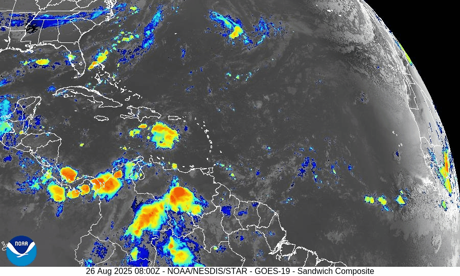
Atlantic Hurricane Outlook – September 4, 2025
On September 4, the Atlantic basin remains quiet with no active storms. The main feature is a tropical wave west-southwest of Cabo Verde, showing signs of organization. The NHC gives it a 50% chance of becoming a tropical depression within 48 hours and 80% within 7 days. It is expected to move west to west-northwest and could approach the eastern Caribbean by mid-next week. The Gulf of Mexico and Florida remain calm, experiencing only typical summer thunderstorms.


TLDR Version: Click Here
Atlantic quiet overall; tropical wave WSW of Cabo Verde likely to become a depression this weekend
Atlantic Basin Overview
Eastern Atlantic disturbance (near 34°W)
Showers and storms tied to a tropical wave several hundred miles west-southwest of the Cabo Verde Islands are getting a bit better organized. The NHC says environmental conditions are conducive for development, and a tropical depression is likely late this week or this weekend as the wave moves W–WNW ~5–10 mph. It should accelerate westward afterward and reach waters east of the Lesser Antilles by mid-next week. Formation odds: 50% (48 hr) and 80% (7 days).
No other active systems
Aside from this wave, no tropical cyclones are active in the Atlantic this morning per NHC outlooks.
Environmental Conditions
Sea Surface Temperatures (SSTs): Warm waters persist across the deep tropics, with widespread warmth expected to favor development as the wave travels west. (NHC notes “conducive” conditions for this system.)
Wind Shear: Broad Atlantic shear has been on the higher side recently, but guidance and outlooks indicate a more favorable pocket near the wave, aligning with the NHC’s expectation of gradual organization.
Mid-level Humidity & SAL: Dry air/Saharan dust remain scattered across the central Atlantic and have been suppressing convection in other waves; conditions are less hostile near the developing disturbance than earlier this week.
Large-scale pattern: Forecasters expect upticks in Atlantic activity in early September given unusually warm waters and supportive intraseasonal signals; still, track confidence for any single wave is low at this lead time.
Gulf of American (Mexico) & Caribbean
The Gulf remains quiet under relatively benign marine conditions; no tropical development is indicated in current NHC products. Offshore forecasts keep light winds and low seas (generally ≤3 ft) through the period.
Florida & Southeast U.S. Forecast
General pattern: Hot, humid late-summer weather with the daily sea-breeze cycle of scattered afternoon thunderstorms continues. No tropical threats for the state are signalled by NHC at this time. (Central Florida forecast discussions also note a lingering boundary with showers/storms, trending a bit drier into the weekend.)
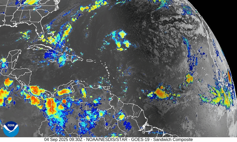
Rain forecast visualization courtesy of Windy.com

Summary
A tropical wave WSW of Cabo Verde has 50% (48 hr) / 80% (7-day) odds to form; a depression is likely late week/weekend as it tracks W–WNW.
No other active tropical cyclones in the Atlantic this morning.
Environment: warm SSTs and a somewhat improved shear/moisture backdrop near the wave support gradual development, but SAL/dry air remain pockets of resistance elsewhere.
Gulf and Florida: quiet from a tropical standpoint; typical afternoon storms, light marine winds, and low seas prevail.
TL;DR – September 4 Snapshot
High-confidence watch: Wave WSW of Cabo Verde likely to become a depression late week/weekend; 80% 7-day odds.
Track window: Guidance favors a west to west-northwest motion toward the east of the Lesser Antilles by mid-next week (too early for specifics).
No other systems active; Gulf & Florida remain in a routine summer pattern with scattered storms and no tropical threats.
Atlantic Hurricane Outlook – September 3, 2025
On September 3, the Atlantic basin remains free of active tropical cyclones. A tropical wave emerging from Africa is showing increased signs of organization, with the NHC assigning a 70% chance of development over the next week. This system could become Tropical Depression Seven or Tropical Storm Gabrielle. Florida and the Gulf of Mexico remain quiet, experiencing only typical late-summer thunderstorms.

TLDR Version: Click Here
Atlantic remains quiet; African wave now has 70% 7-day development odds
Atlantic Basin Overview
No Active Storms
The Atlantic basin continues to be free of active tropical cyclones—no storms are currently present.Tropical Wave Off Africa
A tropical wave exiting Africa is gaining strength. The NHC now gives this system a 0% development chance in 48 hours, rising to 70% over 7 days. Development into Tropical Depression Seven—and possibly Tropical Storm Gabrielle—is considered likely by the weekend.
Environmental Conditions
Sea Surface Temperatures (SSTs): Remain warm in the Caribbean and Gulf (about 29–31 °C) but cooler farther east, where the African wave is located.
Wind Shear: Moderate to strong shear persists across much of the Atlantic but may ease near the developing wave.
Mid-Level Humidity & SAL: Dry air and the Saharan Air Layer (SAL) are widespread, but are expected to diminish along the wave’s path as it tracks westward.
Gulf of America (Mexico) & Caribbean
The Gulf remains quiet, dominated by high pressure. Only routine afternoon thunderstorms are expected along coastal areas; no tropical development is expected at this time.
Florida & Southeast U.S. Forecast
Florida continues with typical early-September weather: hot and humid, with scattered sea-breeze-driven afternoon thunderstorms. No tropical threats are expected. Coastal waters are calmer as the Atlantic’s longtime surf persists from prior systems but gently subsides.
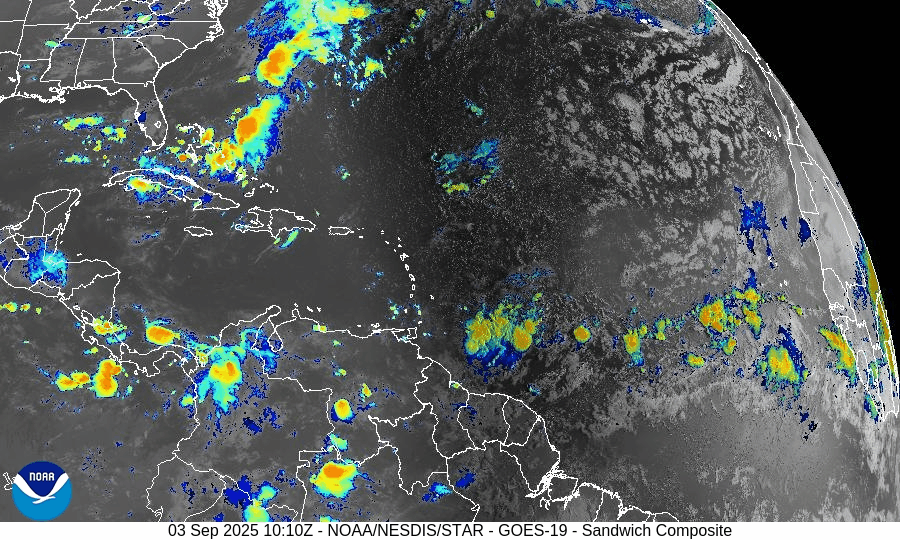
Rain forecast visualization courtesy of Windy.com

Summary
Atlantic basin remains calm with no systems currently active.
A tropical wave off Africa shows a high (70%) chance of developing into a tropical cyclone within 7 days.
Environmental factors—warm SSTs but competing dry air, SAL, and wind shear—will determine if and when development occurs.
Gulf and Florida remain storm-free and continue typical late-summer weather patterns.
TL;DR – September 3 Snapshot
Atlantic is quiet with no storms.
African wave now has 70% development odds over the next 7 days.
Atlantic environment remains marginal but improving near the wave.
Florida and Gulf remain calm with routine storms.

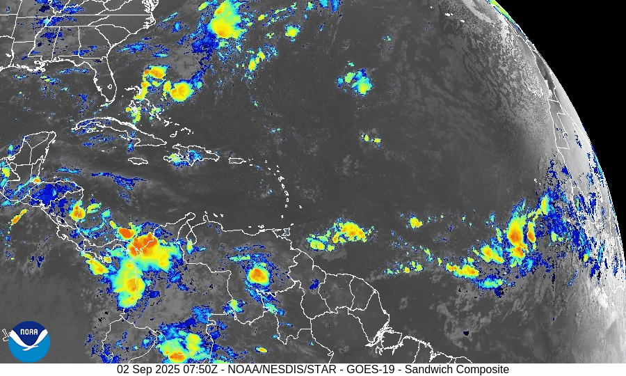
Atlantic Hurricane Outlook – September 2, 2025
On September 2, the Atlantic remains storm-free with no active tropical cyclones. A tropical wave emerging off the coast of Africa shows rising organization and carries a 70% chance of development within 7 days. Environmental conditions are gradually improving, though dry air and Saharan dust remain factors. The Gulf of Mexico and Florida stay calm with only typical early-September thunderstorms.

TLDR Version: Click Here
Atlantic remains quiet; African wave gaining strength with a 70% 7-day development chance
Atlantic Basin Overview
No Active Storms
The Atlantic basin remains clear of any active tropical cyclones.Tropical Wave Emerging off Africa
A tropical wave located south of the Cabo Verde Islands is showing signs of organization. Environmental conditions are becoming more favorable, prompting a forecast of a low 30% chance of formation in the next 48 hours, rising significantly to a high 70% chance of development over the next 7 days.
Environmental Conditions
Sea Surface Temperatures (SSTs): Remain warm (~29–31 °C) in the Caribbean and Gulf, supportive for tropical development. Cooler conditions persist in the open Atlantic.
Wind Shear: Moderate to strong across much of the Atlantic; however, shear is forecast to ease gradually across the eastern tropical Atlantic, aiding organization of the wave.
Mid-Level Humidity & SAL: While dry air and Saharan Dust (SAL) remain present, pockets of increasing moisture near the African wave are aiding its potential development.
Gulf of America (Mexico) & Caribbean
The Gulf remains quiet, dominated by high pressure. Expect only daily sea-breeze afternoon thunderstorms—no tropical development is anticipated.
Florida & Southeast U.S. Forecast
Florida continues with typical early-September weather—hot, humid, and prone to scattered afternoon thunderstorms. There are no tropical threats or coastal hazards affecting the state at this time.
Rain forecast visualization courtesy of Windy.com
Summary

Atlantic basin remains calm, but one African wave shows high development potential (70%) over 7 days.
Environmental factors including SSTs, shear, moisture, and SAL will determine whether it organizes.
Gulf and Florida experience routine late-summer weather; no tropical systems in the near term.
TL;DR – September 2 Snapshot
Atlantic quiet with no storms.
70% chance a wave near Africa develops in the next 7 days.
Warm SSTs but competing shear and dry air—watch environment closely.
Florida and Gulf remain in standard summer pattern.
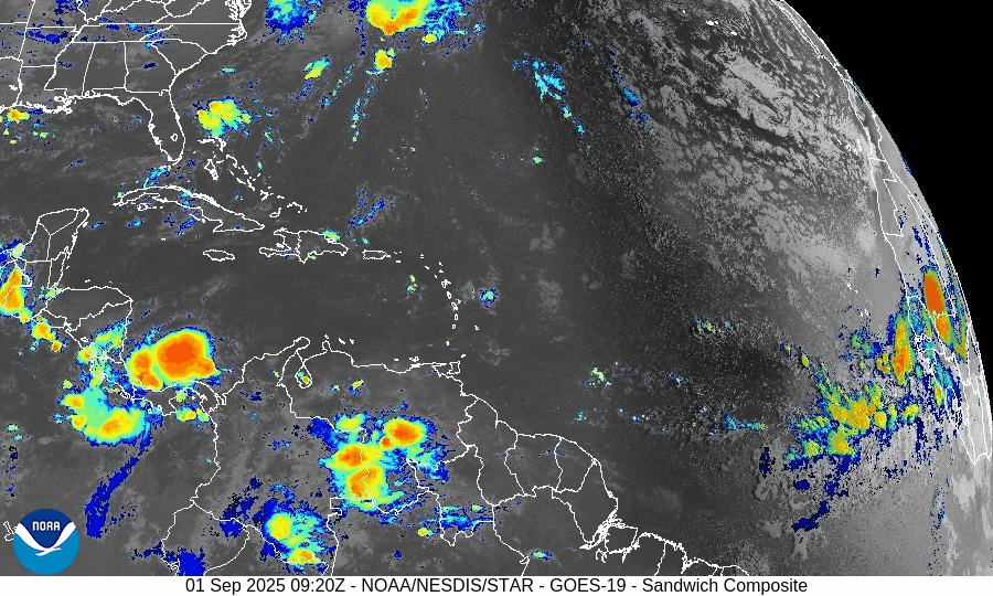
Atlantic Hurricane Outlook – September 1, 2025
On September 1, the Atlantic remains storm-free with no active cyclones. A tropical wave emerging off the coast of Africa carries a 40% chance of development over the next 7 days. While environmental conditions—wind shear, dry air, and Saharan dust—are suppressing rapid growth, the wave will be monitored closely. Florida and the Gulf of Mexico remain quiet, experiencing only typical early-September thunderstorms.

TLDR Version: Click Here
Atlantic remains quiet; tropical wave off Africa shows rising potential (40% over 7 days)
Atlantic Basin Overview
No Active Storms
There are currently no active tropical cyclones in the Atlantic basin—the first tranquil period we've seen since the wake of Fernand and Erin.Emerging Tropical Wave Off Africa
A new tropical wave has emerged off the West Coast of Africa near Guinea-Bissau. Presently disorganized, the NHC assigns it a 0% chance of development in the next 48 hours, but the probability rises to about 40% over the next 7 days. This system will be closely monitored as it moves west across the tropical Atlantic.
Environmental Conditions
Sea Surface Temperatures (SSTs): Remain warm in the Gulf and Caribbean (29–31 °C), while the open Atlantic heat content diminishes northward.
Wind Shear: Elevated shear across much of the basin continues to suppress storm formation.
Mid-Level Humidity & SAL (Saharan Air Layer): Dry air and SAL dust are widespread, inhibiting significant convection and limiting the strength of the new wave emerging off Africa.
Gulf of America & Caribbean
The Gulf remains stable and quiet, under the influence of high pressure. Only routine afternoon sea-breeze thunderstorms are expected—no tropical threats are present.
Florida & Southeast U.S. Forecast
Florida continues in its trademark late-August/early-September pattern: hot, humid, with scattered afternoon thunderstorms. With no active systems nearby, no coastal or tropical threats are expected this week.
Rain forecast visualization courtesy of Windy.com
Summary

No storms are currently active in the Atlantic basin.
A tropical wave off Africa is being monitored, with a 40% chance of developing within 7 days.
Environmental factors—including cool SSTs, strong shear, dry air, and SAL—are suppressing tropical development.
Gulf and Florida remain quiet, with only standard summertime weather patterns in play.
TL;DR – September 1 Snapshot
Atlantic is fully quiet; no active storms.
Tropical wave off Africa now has 40% 7-day development odds.
Hostile conditions in place, limiting immediate storm formation.
Florida and Gulf remain calm, aside from typical daily thunderstorms.

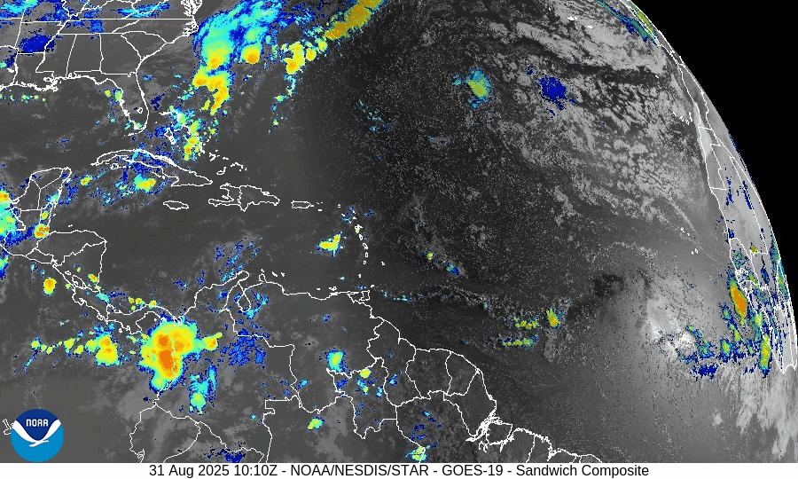
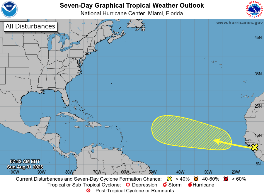
Atlantic Hurricane Outlook – August 31, 2025
On August 31, the Atlantic remains storm-free following the dissipation of Fernand and Erin’s exit. The only feature of interest is a tropical wave moving off Africa, with a low 30% development chance over the next 7 days. Environmental conditions—wind shear, dry air, and Saharan dust—continue to limit storm formation. Florida and the Gulf remain calm aside from typical summer storms.

TLDR Version: Click Here
Atlantic basin remains quiet; a weak wave off Africa shows low (30%) development odds
Atlantic Basin Overview
No Active Storms
There are currently no active tropical cyclones in the Atlantic basin. The calm continues following Fernand’s dissipation and the end of Erin’s impacts.Tropical Wave Near Africa
A tropical wave is forecast to emerge off the west coast of Africa, and the NHC assigns it a low – but not negligible – chance of development: 0% over the next 2 days, increasing to 30% over the next 3 to 7 days.
Environmental Conditions
Sea Surface Temperatures (SSTs): Warm in the Caribbean and Gulf (~29–31 °C), but less favorable conditions in much of the open Atlantic.
Wind Shear: Continues to be elevated across large swaths of the basin, discouraging storm formation.
Mid-Level Humidity & SAL: Dry air and Saharan dust (SAL) remain prevalent, further suppressing convective activity.
Gulf of Mexico & Caribbean
The Gulf remains quiet and stable, dominated by high pressure. Only routine afternoon thunderstorms are occurring along the coasts—no tropical development is expected.
Florida & Southeast U.S. Forecast
Florida continues in its late-August pattern—hot, humid, with scattered afternoon thunderstorms. No tropical threats are present.
Beaches along the Atlantic coast are beginning to calm. With no new swells incoming, rip currents and surf conditions are generally improving, though caution remains prudent in areas still unsettled from earlier systems.
Rain forecast visualization courtesy of Windy.com
Summary

Atlantic basin is currently calm, with no tropical storms or hurricanes active.
A new tropical wave off Africa carries low (30%) development odds over the next week.
Environmental factors (cooler SSTs, shear, dry air, and SAL) continue to limit development potential.
Gulf and Florida remain storm-free, apart from the usual summer thunderstorms.
TL;DR – August 31 Snapshot
The Atlantic is quiet and free of active storms.
A wave off Africa has low (30%) chance of development by next week.
Environmental conditions remain unfavorable for new formations.
Florida and Gulf remain calm with only routine seasonal storms.

Atlantic Hurricane Outlook – August 29, 2025
On August 29, Fernand dissipated in the far North Atlantic, marking the first quiet period in weeks across the basin. No tropical systems are active, though a weak wave off Africa shows low development potential. The Gulf of Mexico and Florida remain calm, experiencing only routine summer thunderstorms.

TLDR Version: Click Here
Fernand has dissipated; no active tropical storms, but a new wave off Africa warrants monitoring
Atlantic Basin Overview
Fernand Has Dissipated
Post-tropical Fernand has fully dissipated over the far North Atlantic. As of the last advisory on August 28, 0900 UTC, it was centered near 41.2°N, 42.9°W, moving east-northeast at ~23 mph with maximum winds of 35 knots (40 mph) and a minimum pressure of 1009 mb. No further advisories will be issued, and the system is no longer a threat to land.
No Active Tropical Systems
Currently, there are no active tropical storms or hurricanes in the Atlantic basin. Model tracking tools confirm the basin is completely clear of active systems.
New Disturbance Emerging Near Africa
The NHC is observing a tropical wave east of the Cabo Verde Islands. This wave features no significant convection and is currently under the influence of Saharan dust. While its development odds are low in the short term, there’s a 20% chance of development over the next 7 days.
Environmental Conditions
Sea Surface Temperatures (SSTs): Warm waters (~29–31 °C) persist in the Gulf and Caribbean, but cooling temperatures across the open Atlantic now that Fernand is gone.
Wind Shear: Elevated wind shear continues to suppress development across most of the Atlantic.
Mid-Level Relative Humidity & Saharan Air Layer (SAL): Dry air and SAL dust are prevalent—particularly near the new wave off Africa—further hampering development.
Gulf of America (Mexico) & Caribbean
The Gulf remains quiet and stable, with high pressure dominating. Only typical afternoon thunderstorms are expected; no organized or tropical development is forecast.
Florida & Southeast U.S. Forecast
Florida continues to experience standard late-summer weather—hot, humid, with scattered afternoon thunderstorms. The absence of major tropical features means no new coastal threats.
Atlantic beaches are finally beginning to calm after prolonged rough surf from previous systems, though caution remains advised where noticeable wave action persists.
Rain forecast visualization courtesy of Windy.com
Summary

Fernand has dissipated; no tropical cyclones remain in the Atlantic.
Atlantic remains quiet, with only a small wave emerging near Africa carrying limited development potential.
Environmental factors—cooler SSTs, wind shear, dry air, and SAL—continue to suppress tropical activity.
Gulf and Florida show no signs of tropical development, carrying on with typical summer weather patterns.
TL;DR – August 29 Snapshot
Fernand is no longer active and poses no threat.
Atlantic basin is quiet—only a minor wave off Africa is being watched.
Environmental conditions remain unfavorable for storm formation.
Florida and Gulf continue with routine stormy weather; beaches are calming.
Atlantic Hurricane Outlook – August 27, 2025
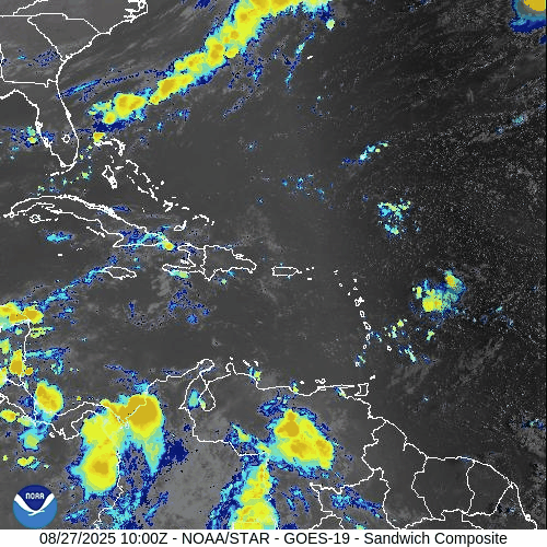
On August 27, Tropical Storm Fernand transitioned into a post-tropical system southeast of Newfoundland. While Fernand poses no threat to land, Erin’s long-period swells continue to drive dangerous surf and rip currents from the Carolinas through New England. Florida and the Gulf of Mexico remain calm, with only typical late-August thunderstorms and no signs of tropical development.
TLDR Version: Click Here
Tropical Storm Fernand becomes post-tropical over open waters; East Coast surf threats persist
Atlantic Basin Overview

Tropical Storm Fernand
As of 5 AM AST (0900 UTC), Fernand is situated near 38.3° N, 50.8° W, approximately 590 miles southeast of Cape Race, Newfoundland. The system carries sustained winds of 45 mph, is moving east at 12 mph, and maintains a central pressure of 1007 mb.
No coastal watches or warnings are active. Fernand is expected to transition into a post‑tropical system later today, then evolve into a trough and dissipate by Thursday.
Hurricane Erin’s Lingering Surf Impacts
Despite being long gone, Erin's energy continues to affect coastal waters. East Coast beaches—from the Carolinas through New England—continue to experience rough surf and dangerous rip currents.
No Other Tropical Activity
There are no new tropical disturbances of concern at this time, and forecast models show an inactive Atlantic basin in the short term.
Environmental Conditions
Sea Surface Temperatures (SSTs): Waters remain warm in the subtropics but are cooling northward—supporting Fernand's decay.
Wind Shear: Moderate winds aloft are increasing and will help dissipate Fernand.
Mid-Level Humidity & SAL: Dry air and dust from the Saharan Air Layer still suppress convection across the Atlantic, limiting new storm formation.
Gulf of Mexico & Caribbean
The Gulf remains quiet and stable, dominated by high pressure. Afternoon thunderstorms continue in coastal areas, but no tropical development is expected.
Florida & Southeast U.S. Forecast
Typical late-August weather prevails: hot and humid with scattered afternoon storms across Florida.
Beaches along the Atlantic continue to face elevated rip current risks, driven by the lingering swell from Erin and residual energy from Fernand.
Rain forecast visualization courtesy of Windy.com
Summary

Fernand weakens as it becomes post-tropical; no land threat.
Erin’s surf legacy continues to endanger East Coast recreation.
Atlantic basin remains quiet—no new systems.
Gulf and Florida are calm aside from routine summer storms.
Hostile environmental conditions (cooler SSTs, shear, dry air, SAL) limit development.
TL;DR – August 27 Snapshot
Fernand becomes post-tropical in the open ocean—no land threat.
Rip currents and rough surf continue to challenge East Coast beaches.
Active development unlikely; Atlantic remains quiet.
Florida and Gulf of Mexico see only typical summer storms.
Atlantic Hurricane Outlook – August 26, 2025
On August 26, Tropical Storm Fernand weakened over cooler waters east-northeast of Bermuda and is expected to become post-tropical by Wednesday. While Fernand poses no threat to land, Erin’s swells are still driving dangerous rip currents along the U.S. East Coast. Florida and the Gulf of Mexico remain quiet, experiencing only typical late-August thunderstorms.
TLDR Version: Click Here
Tropical Storm Fernand weakens offshore; Erin’s surf legacy lingers while tropics turn quiet
Atlantic Basin Overview
Tropical Storm Fernand

As of Tuesday morning, Fernand is located about 635 miles east-northeast of Bermuda, moving northeast at ~14 mph with maximum sustained winds near 45 mph and a central pressure of 1005 mb. The storm has weakened over cooler waters and moderate shear, and is forecast to transition into a post-tropical system by Wednesday, dissipating altogether by Thursday. No watches or warnings are in effect, and Fernand poses no threat to land.
Hurricane Erin’s Legacy
Though Erin has been gone for days, its immense size and powerful wave field continue to leave a footprint along the East Coast. Long-period swells and dangerous rip currents remain a hazard from the Carolinas through New England, particularly in areas with open exposure to the Atlantic.
Other Atlantic Activity
The National Hurricane Center reports no active disturbances of concern. A tropical wave that had entered the Caribbean has been choked off by dry air and shear, with 0–10% development odds over the next week
Environmental Conditions
Sea Surface Temperatures (SSTs): The Caribbean and Gulf remain very warm (29–31 °C), supportive of storm formation. In the North Atlantic, Fernand is moving into cooler waters, which will force weakening.
Wind Shear: Shear is moderate over Fernand and forecast to increase, hastening its post-tropical transition. Stronger shear persists across much of the MDR, suppressing new development.
Mid-Level Relative Humidity: Dry mid-level air continues across the central Atlantic, limiting convective organization for any tropical waves.
Saharan Air Layer (SAL): Dust-laden air spans the eastern and central Atlantic, further capping deep convection and hindering tropical development.
Gulf of Mexico & Caribbean
The Gulf remains quiet under high pressure, with no signs of organized development. Only routine afternoon thunderstorms are occurring along coastal regions. Despite very warm waters, the Gulf shows no near-term tropical threats.
Florida & Southeast U.S. Forecast
Florida is under a typical late-August pattern: hot, humid conditions with scattered afternoon thunderstorms driven by sea breezes. Some morning showers are possible along the Gulf Coast.
Along the Atlantic beaches, hazardous surf and rip currents remain the main concern, with energy still propagating from Erin’s remnants and Fernand’s offshore circulation
Rain forecast visualization courtesy of Windy.com

Summary
Fernand has weakened to a 45 mph storm and will become post-tropical by Wednesday.
Erin’s legacy continues to affect the East Coast with dangerous surf and rip currents.
No new Atlantic systems show signs of development; odds remain very low.
Gulf of Mexico and Florida are quiet, with only routine late-summer storms.
Environmental conditions: Warm SSTs but hostile shear, dry air, and SAL are suppressing new activity.
TL;DR – August 26 Snapshot
Fernand weakens offshore; no land impacts expected.
Erin’s swells continue to fuel rip currents along the East Coast.
SAL, dry air, and wind shear are limiting new storm development.
Gulf and Florida remain quiet aside from typical thunderstorms.
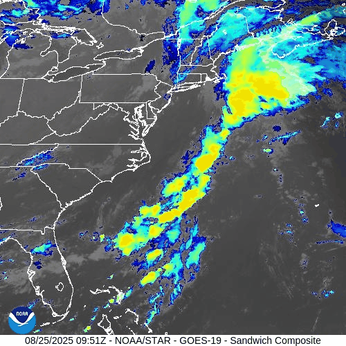
Atlantic Hurricane Outlook – August 25, 2025
Tropical Storm Fernand continues east of Bermuda with sustained winds near 50 mph and will weaken as it moves into cooler waters. Erin’s legacy swells still drive dangerous surf and rip currents from the Carolinas to New England. Florida and the Gulf remain calm, with only routine summer thunderstorms.
TLDR Version: Click Here

Tropical Storm Fernand holds strength offshore; environmental factors limit wider Atlantic development
Atlantic Basin Overview
Tropical Storm Fernand
Fernand is located about 360 miles east-northeast of Bermuda, carrying sustained winds near 50 mph while moving north-northeast at ~12 mph. The system may strengthen slightly today but will soon encounter cooler waters and stronger upper-level winds, leading to weakening and a transition to a post-tropical cyclone by midweek. No coastal warnings are in effect, and Fernand poses no threat to land.
Hurricane Erin’s Legacy
Erin’s powerful circulation has long dissipated, but the swell energy lingers. Beaches from the Carolinas to New England remain at risk for dangerous rip currents, elevated surf, and localized erosion, even as skies improve inland.
Other Atlantic Activity
A tropical wave in the Caribbean and another in the central Atlantic show low development chances. The NHC assigns only a 10% probability of tropical formation through 7 days. Dry air and hostile shear continue to suppress organization.
Gulf of America (Mexico) & Caribbean
The Gulf is quiet under high pressure with only routine afternoon thunderstorms along the coast. Very warm waters (29–31 °C) cover the basin, but no tropical development is expected in the near term.
Florida & Southeast U.S. Forecast
Florida remains locked in a late-August cycle: hot, humid conditions and scattered afternoon thunderstorms driven by the sea breeze. Some areas also see morning showers drifting in from the Gulf, making for a two-phase rain pattern.
No tropical threats are present, but Atlantic beaches continue to face rip current risks due to Fernand’s swells and Erin’s lingering wave action.
Rain forecast visualization courtesy of Windy.com
Environmental Conditions
Sea Surface Temperatures (SSTs): The Caribbean and Gulf of Mexico are running 29–31 °C (84–88 °F), supportive of development. In the western Atlantic, SSTs are warm enough to sustain Fernand briefly, but cooler waters to the north will drive weakening.
Wind Shear: Currently low to moderate around Fernand, allowing some maintenance of strength. However, increasing shear northward will disrupt convection and hasten its post-tropical transition. Shear also remains moderate to strong across much of the MDR, suppressing other disturbances.
Mid-Level Relative Humidity (RH): Dry air pockets persist in the central Atlantic, limiting organization of Invest 99L and other waves. Moisture is more favorable closer to the Caribbean and Gulf.
Saharan Air Layer (SAL): SAL dust continues to intrude across parts of the eastern and central Atlantic, reducing convection and capping development potential.
Summary

Fernand is a 50 mph tropical storm, staying well offshore and weakening by midweek.
Erin’s swells continue to fuel dangerous surf and rip currents along the East Coast.
Environmental conditions (SSTs supportive, but SAL, dry mid-level air, and increasing shear) are limiting further Atlantic development.
Gulf and Florida remain quiet, aside from routine thunderstorms and coastal surf hazards.
TL;DR – August 25 Snapshot
Fernand stays offshore, no U.S. land threat, weakening soon.
Rip currents and surf hazards linger along the East Coast.
SAL, shear, and dry mid-level air suppress new storm formation.
Gulf and Florida remain in a routine summer pattern.
As always, check back at CAT5Prep.com for daily hurricane updates, and also visit our Hurricane Prep Blog to find ways you can prepare during hurricanes.