
Atlantic Hurricane Outlook – August 4, 2025: Tropical Storm Dexter Forms; Two Other Systems Under Watch
Tropical Storm Dexter forms off the East Coast with no land threat. Meanwhile, a tropical wave off Africa and a low near the Southeast U.S. are being monitored as conditions slowly shift toward a more active period.
*Those who like data, continue reading. Those it prefer the quick version, jump to the TL;DR here.
Tropical Storm Dexter has developed in the western Atlantic, while two additional systems are being monitored for potential development. Conditions across the basin remain dynamic—with storm formation possible in coming days.
Atlantic Basin Summary
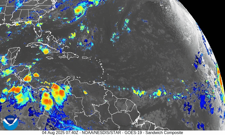
Tropical Storm Dexter: The fourth named storm of the 2025 season formed late Sunday night, now located ~255 miles northwest of Bermuda. Maximum sustained winds are 45 mph, and the system is moving east-northeast. It’s expected to remain over open water and become post-tropical by Wednesday with no threat to U.S. land.
Disturbance AL95: A non-tropical low pressure area off the Southeast U.S. coast is being monitored with medium (30%) development chance over 7 days. Movement is east-northeast under weak shear, and formation may remain offshore.
New tropical wave emerging off Africa (~30°W): Forecast to track westward with scattered convection. The formation chance is 50% over 7 days, indicating growing potential for a tropical depression if favorable conditions develop.
Environmental Conditions
Sea Surface Temperatures (SSTs):
Waters in the Gulf of Mexico, Caribbean, and MDR remain warm at 29–31°C (84–88°F)—providing ample energy if atmospheric conditions become supportive.Wind Shear:
Still moderate to high across much of the Atlantic, limiting vertical storm structure. However, shear may relax in the western basin later this month.Saharan Air Layer (SAL):
Persistent dry, dusty air continues to suppress convection, especially over the eastern and central Atlantic. This remains a major inhibiting factor for newly emerging systems.Moisture:
Improving moisture levels seen in the western Caribbean and Gulf, though much of the basin remains too dry for sustained disturbance development.
Gulf of America (Mexico) & Caribbean Region
No tropical systems currently forming.
A dominant high-pressure ridge promotes generally calm, hot conditions across the Gulf and Caribbean.
Scattered showers remain typical for August, with no organized convection tied to tropical disturbances.
GOES-19 - Sector view: Gulf
GOES-19 - Sector view: Caribbean
Florida Forecast
Highs: Upper 80s to near 90°F under humid conditions.
Afternoon thunderstorms: 40–50% chance, typically from sea breeze convergence—non-tropical in origin.
Winds: Light and variable inland; southeasterly near the coast.
No tropical storm impacts are expected today.
Rain forecast visualization courtesy of Windy.com
Prep Tip of the Day
Stay connected to emerging tropical watches and alerts: sign up for NOAA and county-level emergency notifications, test weather radios, and review your communication plans with family or household members.
Looking Ahead
Though Dexter poses no immediate risk to land, the emerging wave and mid-Atlantic trough (AL95) warrant attention. The signal is clear: early August may mark the beginning of a more active period in the tropical Atlantic.
TL;DR – August 4, 2025 Summary
Tropical Storm Dexter forms off the East Coast—staying far offshore and weakest by midweek.
Low pressure (AL95) offshore Southeast U.S. with 30% development chance.
New wave off Africa (~30°W) entering the Atlantic—50% chance of development in 7 days.
SSTs supportive but SAL and shear remain inhibitory.
No threat to Florida; typical summer thunderstorms expected.

Atlantic Hurricane Outlook – July 30, 2025: Development Chances Remain Low
As July ends, the Atlantic Basin sees active tropical waves, but development chances remain low for the next 7 days. Discover the latest on sea surface temperatures, wind shear, Saharan Air Layer, and the outlook from CAT5Prep.com.
*Those who like data, continue reading. Those it prefer the quick version, jump to the TL;DR here.
** Due to technical issues on the GOES satellite imagery provider's end, we are currently unable to display real-time satellite imagery.
The Atlantic Basin remains active with multiple tropical waves stretching from the African coast to the Caribbean, yet no organized development is expected in the near term. Wind shear and Saharan dust continue to suppress cyclone formation despite warm ocean temperatures and a moistening atmosphere in the western basin.
As we close out July, conditions are slowly trending toward a more favorable setup for storm development heading into August.
Atlantic Basin Overview
As of the 8:00 AM EDT NHC Tropical Weather Outlook:
No active tropical cyclones.
Three tropical waves span the Atlantic:
Wave near 35°W (eastern Atlantic): Disorganized, little convection.
Wave near 50°W (central Atlantic): Producing scattered thunderstorms, no surface low.
Wave in the eastern Caribbean: Weak and encountering dry air and shear.
NHC Development Odds:
Next 48 hours: 0%
Next 7 days: 0%
Key Environmental Factors
SST data courtesy of Windy.com
Wind data at 850hPa from Windy.com
Sea Surface Temperatures (SSTs):
29–31°C (84–88°F) in the Gulf of Mexico and Caribbean.
MDR remains slightly warmer than normal.
Wind Shear:
Moderate across the central Atlantic and Caribbean.
Suppressing vertical development for now.
Saharan Air Layer (SAL):
Strong dry air across much of the basin.
Limiting convection and keeping tropical waves disorganized.
Moisture:
Gradually increasing in the western Atlantic and Caribbean.
A factor to monitor as wind shear begins to ease.
Gulf of Mexico (Gulf of America)
A weak surface trough in the central Gulf is producing scattered showers and isolated thunderstorms.
No signs of organization, and the NHC does not expect development at this time.
High pressure remains dominant elsewhere, with calm conditions expected through midweek.
Florida Weather
Highs in the upper 80s to low 90s with high humidity.
Scattered thunderstorms possible in the afternoon and evening from sea breeze interactions.
No tropical threats to Florida at this time.
Radar imagery courtesy of Windy.com
Outlook & Preparedness
The Atlantic remains broadly quiet for now, but the environment is slowly shifting. A steady wave train emerging off Africa and increasingly favorable SSTs point to a more active window in early to mid-August.
Now is the time to double-check hurricane kits, review evacuation zones, and prepare while the weather allows.
TL;DR – July 30 Snapshot
No tropical development expected this week.
Three tropical waves are present but remain weak and disorganized.
SAL and shear are limiting development.
Conditions should become more favorable by early August.
Atlantic Hurricane Outlook – July 28, 2025: Waves Active, Tropics Stable for Now
Tropical waves are stirring across the Atlantic, but no development is expected over the next 7 days. Warm waters and weakening wind shear suggest conditions could shift heading into August.

*Those who like data, continue reading. Those it prefer the quick version, jump to the TL;DR here.
As the final days of July unfold, the Atlantic basin remains active with several tropical waves but no immediate threats. While sea surface temperatures and atmospheric moisture continue to support development, upper-level wind shear and dry air are keeping conditions broadly stable—though this pattern may shift as we enter August.
Atlantic Basin: Multiple Waves, No Cyclones (Yet)
As of 8:00 AM EDT from the National Hurricane Center:
No active tropical cyclones
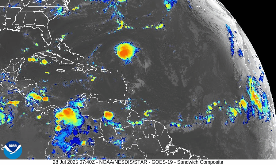
Two tropical waves are under watch:
Tropical Wave 1: Located near 40°W, moving westward at 10–15 kt with scattered convection. Still disorganized but under observation.
Tropical Wave 2: Recently emerged off Africa near 23°W, with convection along its southern flank. It’s embedded in a moist environment and will be monitored for future development.
No development expected over the next 7 days, but long-range models suggest increasing favorability for late next week.
Gulf of Mexico: Moisture Returns, But No Development
A weak surface trough lingers in the Bay of Campeche, producing isolated showers and thunderstorms.
No signs of tropical development at this time.
Expect scattered showers and storms across the eastern and central Gulf through Tuesday, driven by daytime heating and lingering mid-level moisture.
Caribbean Sea: Typical Summer Conditions
Fresh to strong trades continue in the central and southwest Caribbean, particularly off the coasts of Colombia and Venezuela.
Some isolated thunderstorms are active near Panama and the Windward Passage.
A tropical wave moving through the eastern Caribbean is enhancing convection, but remains disorganized.
Atlantic Main Development Region (MDR): Slowly Activating
Sea surface temperatures (SSTs):
MDR: 28–29°C (82–84°F), well above climatological norms.
Gulf and Caribbean: 30–31°C (86–88°F), fuel-ready.
Saharan Air Layer (SAL): Dry air continues to suppress convection over much of the MDR, but signs show it is beginning to weaken, allowing thunderstorm clusters to persist longer.
Wind shear: Still present in the central Atlantic, but trending downward.
SST data courtesy of Windy.com
Florida Outlook: Typical Late-July Storms
North Florida: Partly sunny with highs in the upper 80s. Afternoon storms possible.
Central Florida: Hot and humid (highs ~91°F) with scattered PM thunderstorms likely.
South Florida: Muggy with highs in the upper 80s. Thunderstorms expected after 2 PM.
Radar imagery courtesy of Windy.com
Prep Tip of the Day: Inventory Your Storm Gear
Now is a good time to audit your hurricane kit:
Check expiration dates on food, batteries, and meds.
Reassess your generator fuel supply and run a quick test.
Confirm family members know where the supplies are stored.
Looking Ahead: Eyes on Early August
While July is ending quietly, model ensembles hint at better organization potential in the MDR during the first 7–10 days of August.
A Kelvin wave (a burst of upper-level moisture and instability) may traverse the Atlantic next week, setting the stage for more robust wave activity.
TL;DR – July 28, 2025 Hurricane Snapshot
No active storms or tropical depressions
Two tropical waves being watched, neither near development
Gulf and Caribbean: Moist, unsettled, but not organized
MDR: Warm and slowly transitioning to a more favorable pattern
Florida: Classic summer pattern — hot, humid, and stormy afternoons
Outlook: Low risk this week, but August may bring change
Stay informed at Cat5Prep.com, and use this calm to finalize your preparations.
Atlantic Hurricane Outlook – July 13, 2025: Tropics Quiet, Gulf Trough Under Watch
No named storms today, but a low-pressure trough drifting toward the Gulf of Mexico could bring rain and potential tropical development later this week.
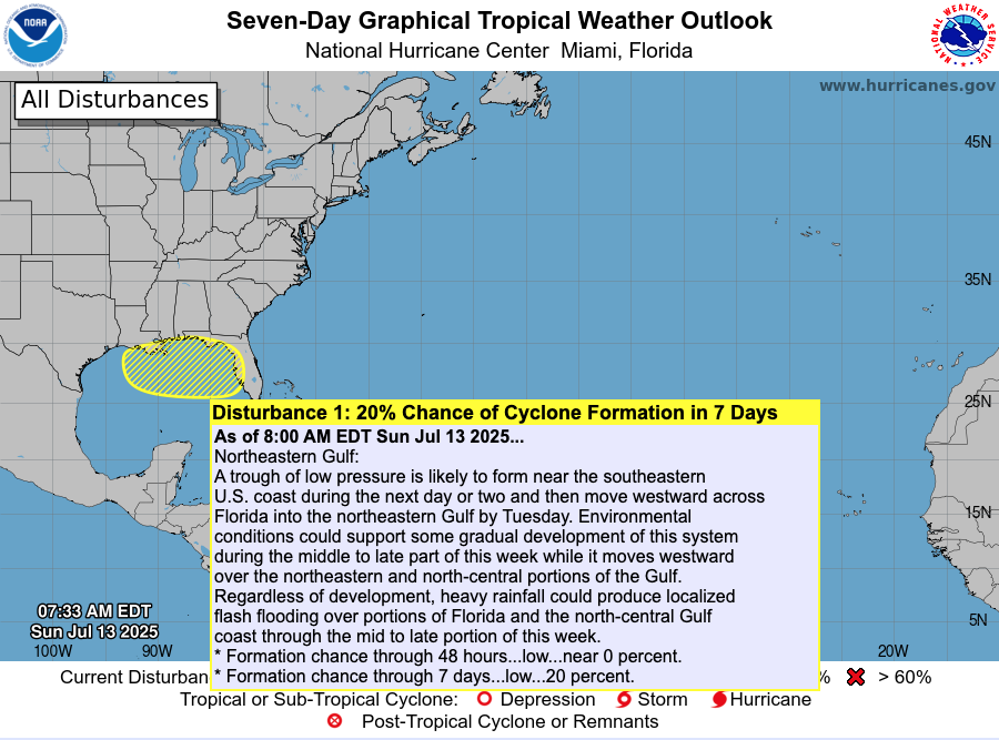
The Atlantic basin remains calm today, with no active named storms. However, meteorologists are tracking a low-pressure trough emerging off the Southeast U.S. coast, gradually drifting into the Gulf of Mexico. This system has a low (20%) chance of organizing into a subtropical or tropical system later this week .
Atlantic Overview: Quiet But Evolving
As per the 8 AM EDT NHC Tropical Weather Outlook:
No active tropical cyclones across the basin.
The Southeast U.S. trough is expected to push into the Gulf by Tuesday.
Formation chances: <1% in next 48 hours, ~20% over 7 days .
Though not tropical now, its movement may increase rainfall and raise attention if organization begins.
Satellite view via Windy.com
Sea Surface Temperatures: A Warm Platform
The Gulf of Mexico continues to show SSTs 2–4°F above average, providing a warm environment for storm development later this season.
Caribbean and Main Development Region (MDR) SSTs also remain elevated, keeping hurricane fuel accessible .
Sea Surface Temperature via Windy.com
Atmospheric Setup: Suppression in Play

Wind Shear Courtesy of https://tropic.ssec.wisc.edu/
Wind shear remains moderately strong across much of the basin, hindering storm development.
Saharan dust is still prevailing over the eastern Atlantic, suppressing early-season storm growth.
Moisture levels are slowly increasing in the Gulf and Southeast U.S., signaling gradual support for convection.
Saharan Air Layer (Dust) via Windy.com
Regional Weather: Rain on the Rise
Expect increased showers and thunderstorms along the Southeast U.S. and Gulf coasts as the trough approaches.
Florida will likely see scattered afternoon storms, typical for July, especially as the trough draws moisture inland.
Thunderstorm Forecast (ECMWF) via Windy.com
Prep Tip of the Day: Be Rainwise
Even without strong winds, heavy rainfall can pose serious hazards:
Track the trough’s movement—it could bring localized flash flooding to Gulf coast areas.
Ensure storm drains and sump pumps are clear and functional.
Keep sandbags and quick barriers ready if you're in low-lying zones.
Test your NOAA Weather Radio and mobile alerts to stay ahead of rainfall warnings.
Looking Ahead: Waters Stay Warm—Storms Could Spark
Although the tropics are peaceful now, the combination of warm ocean temperatures, easing atmospheric inhibitors, and growing seasonal moisture suggest readiness for evolution. The trough may serve as the first spark of Gulf activity, with a watchful eye needed through mid- to late-week.
Stay alert and check back tomorrow for your latest update from Cat5Prep.com.

Atlantic Hurricane Outlook – June 20, 2025: Tropics Hold Quiet as Atlantic Patterns Begin to Shift
The Atlantic remains calm with no storms expected, but warm waters and shifting atmospheric patterns hint that the quiet may not last. A developing Atlantic Niña could hit a reversal and amplify activity later this season.
As we close out the third week of the 2025 Atlantic hurricane season, the basin remains quiet. No named storms or tropical disturbances are being monitored by the National Hurricane Center (NHC), and no development is expected over the next 7 days. However, behind this calm lies a subtle shift in Atlantic patterns that may influence storm activity in the weeks ahead.
Atlantic Basin: All Clear—for Now
As of the latest NHC update (8 AM EDT, June 20):
No active tropical cyclones
No areas of interest
No tropical development expected through late June
This type of quiet is typical for mid-June, historically a transitional period before activity ramps up in July and peaks from August to October.
Satellite view via Windy.com
Sea Surface Temperatures: Still Hot, Still Fuel
Sea surface temperatures (SSTs) across much of the Atlantic remain well above normal:
Gulf of America (Mexico): Mid to upper 80s°F (29–31°C), 2–4°F above average
Western Caribbean: Similar anomalies, particularly near the Yucatán and Cuba
Main Development Region (MDR): Still warming gradually, trending toward conditions that could support long-track storms later this season
Warm SSTs are a critical energy source for hurricanes—and the heat is already in place.
Sea Surface Temperature (ECMWF Analysis) via Windy.com
Atmospheric Conditions: Neutral ENSO, but Atlantic Cooling Briefly
While the Pacific remains in an ENSO-neutral phase, a rare “Atlantic Niña” has recently emerged—marked by cooler-than-average sea surface temperatures in the eastern tropical Atlantic off the coast of Africa, as seen in the NOAA Coral Reef Watch chart below with a pocket of blue.
This can temporarily suppress early-season hurricane formation by reducing convection and stabilizing the atmosphere
However, models indicate that this pattern may reverse in July, shifting into a warmer Atlantic Niño phase, which typically boosts tropical activity
So, while the Atlantic Niña may be limiting development now, forecasters are closely watching the timing of this transition. Safe money would be on a reversal, which could super charge storm breeding.

Overall Scope of Sea Temperature Anomalies
Saharan Air Layer: Still Limiting Tropical Waves

Wind Shear Courtesy of https://tropic.ssec.wisc.edu/
A strong Saharan Air Layer (SAL) remains entrenched across the tropical Atlantic:
Dry, dusty air suppresses thunderstorm development
Increases stability and upper-level wind shear
Common in June, but typically weakens by mid-July
For now, SAL continues to act as a shield against organized tropical development in the Main Development Region.
Saharan Air Layer (Dust) data via Windy.com
Thunderstorm Activity: Mostly Seasonal and Local
While no tropical organization is underway, convection continues to pop up in key regions:
Florida and Gulf Coast: Afternoon storms due to heat and humidity
Western Caribbean: Scattered convection, but unorganized
Eastern Atlantic: A few tropical waves exiting Africa remain weak and embedded in dry air
These thunderstorms are typical for the season and do not currently show signs of tropical development.
Thunderstorm Forecast (ECMWF) via Windy.com
Florida Forecast
Highs: Upper 80s to low 90s°F (31–33°C)
Humidity: High
Afternoon Storms: Scattered area of thunderstorms likely after 2 PM
Winds: Light and variable, with storm gusts possible
Flooding in low-lying areas is possible if storms linger over one area.
Rainfall Forecast (ECMWF) via Windy.com
Prep Tip of the Day: Restock Pet Supplies
Don’t forget your furry family members when preparing for hurricane season:
Have a two-week supply of pet food, medications, and water
Keep vaccination records and vet contact info in your go-bag
Prepare a small pet first-aid kit
Label pet carriers clearly and store them where they’re easy to grab
Looking Ahead: Transition Coming
For now, the Atlantic basin is calm. But forecasters continue to watch:
Warm SSTs
Easing wind shear
Gradual return of moisture
Potential reversal from Atlantic Niña to Atlantic Niño
All signs point to a more active environment forming as we move into July. Stay alert, stay prepared, and check back tomorrow for your daily hurricane outlook from Cat5Prep.com.

Atlantic Hurricane Outlook – June 17, 2025: Tropics Remain Quiet Despite Peak Heat
The Atlantic basin remains calm with no tropical storms in sight, despite record ocean heat and widespread Saharan dust. Forecasters continue monitoring subtle environmental shifts that could drive activity later this month.
The Atlantic basin remains clear today, with no active tropical cyclones and no tropical development expected over the next seven days, according to the National Hurricane Center’s 2 AM EDT outlook. Despite intense heating of sea surfaces, climatic factors are currently suppressing system formation.
Atlantic Basin: Calm, But Conditions Are Charged
No tropical cyclones or disturbances are being monitored. The Atlantic basin is experiencing what experts are calling an “unusual lull”—something highlighted recently by the Houston Chronicle, which also noted the ongoing Saharan dust presence suppressing early-season activity.
Satellite view via Windy.com
Sea Surface Temperatures: Fuel Ripe, But Storms Dormant
Gulf of America (Mexico) & Western Caribbean: Waters are hovering near 2°F above average, reaching 84–88°F, akin to early June 2024—an impressively warm baseline for storm development.
Main Development Region (MDR): Also experiencing above-average SSTs, laying the groundwork for future storm growth, though not yet fueling storms.
Sea Surface Temperature via Windy.com
Atmospheric Dynamics: Still Holding Back Storms

Wind Shear Courtesy of https://tropic.ssec.wisc.edu/
Wind Shear: Remains moderate to high, hindering storm organization across key regions.
Mid-Level Moisture: Slowly increasing, which may support thunderstorm development—but conditions remain insufficient for cyclones.
Saharan Dust Layer: A steady plume of Saharan air continues to suppress convection, reinforcing atmospheric stability across the Atlantic.
Saharan Air Layer (Dust) via Windy.com
Thunderstorm Activity: Local Showers Only
Florida and much of the Southeast will experience typical midday and afternoon thunderstorms driven by summer heat—not tropical systems. The Caribbean and Atlantic remain clear, with no signs of cluster formation or rotation.
Thunderstorm Forecast (ECMWF) via Windy.com
Florida Forecast (Statewide Conditions)
Highs: Upper 80s to low 90s °F (31–33 °C)
Humidity: Rising—classic early-summer humidity
Rain: Scattered afternoon storms likely, locally intense but short in duration
Visibility & Air Quality: Possible haze from Saharan dust in some southern counties
Winds: Light and variable, with stronger gusts near storm cells
Rainfall Forecast (ECMWF) via Windy.com
Prep Tip of the Day: Dust Alert and Kit Check
Today’s calm weather can hide hidden risks from dust and heat. Take action:
Improve indoor air quality: change HVAC filters and open windows carefully
Wear masks or stay indoors if sensitive to dust
Check your hurricane supplies and evacuation plans
Ensure NOAA Weather Radio and mobile alerts are operational
Bookmark trusted sites, like Cat5Prep.com and hurricanes.gov
Looking Ahead: Quiet Doesn't Mean Safe
No tropical development is expected in the next week, but climatological factors suggest the lull is temporary. Warm ocean temperatures and increasing moisture may spark storm formation later in June. Monitor daily updates as conditions evolve.