
Atlantic Hurricane Outlook – August 19, 2025: Hurricane Erin holds as a powerful Category 3
Hurricane Erin remains a powerful Category 3 offshore system, bringing life-threatening surf, rip currents, and coastal flooding to the East Coast. Meanwhile, the Gulf of Mexico and Florida stay calm with no new tropical threats expected.
TLDR Version: Click Here

Hurricane Erin holds as a powerful Category 3; Life-threatening surf and flooding are poised to impact the East Coast
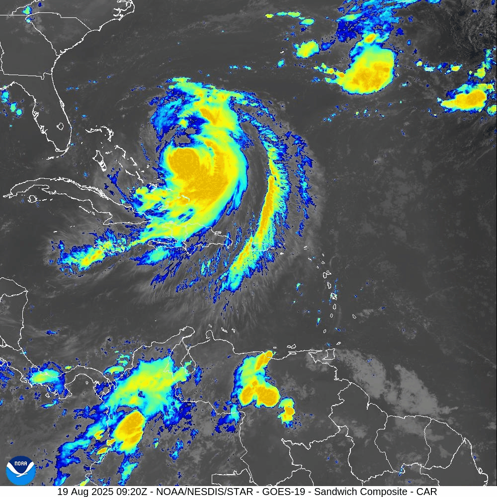
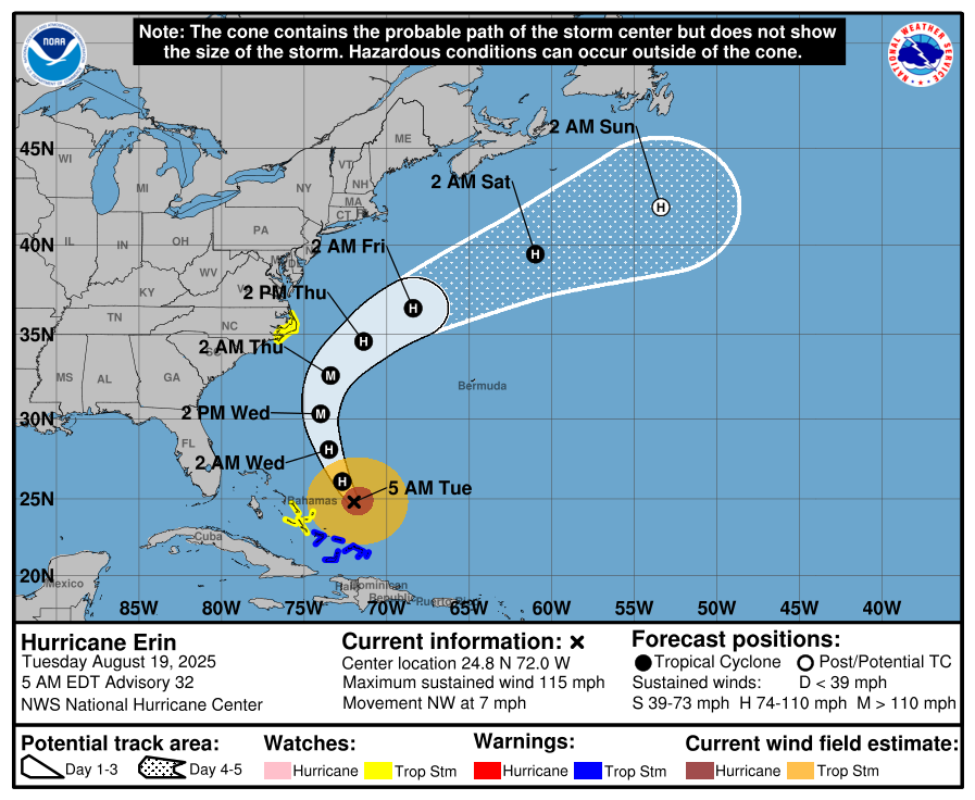
Hurricane Erin, now a Category 3 system with sustained winds near 115 mph, continues its path just east of the Bahamas. While a U.S. landfall remains unlikely, significant coastal impacts are unfolding. Meanwhile, the Gulf of Mexico and Florida remain calm.
Atlantic Basin Overview
Hurricane Erin (Cat 3): Sustained winds are approximately 115 mph. The storm remains offshore, shifted slightly northwest, and continues to drive dangerous surf and rip currents from Florida through New England. Forecasters warn of coastal flooding, storm surge, and beach erosion—especially across the Outer Banks, where evacuation orders are in effect. Waves are expected to reach 15–25 feet, with minor to moderate flooding along the Mid-Atlantic coast. Erin feels the effects of a prior eyewall replacement cycle and is now in a weakening trend influenced by increased shear and dry air.
Other Atlantic systems: No immediate new tropical cyclones are expected. The National Hurricane Center continues to monitor waves and disturbances, but environmental conditions (dry air, wind shear) remain inhibiting.


Gulf of America (Mexico)
Quiet and stable: There are no organized systems. Activity is limited to isolated afternoon convection along the Gulf Coast, tied to heat-driven storm patterns rather than tropical development.
Florida & Southeast U.S. Outlook
Florida Peninsula: Expect routine summertime weather—afternoon thunderstorms fueled by sea breezes. No tropical threats are anticipated.
East Coast (NC to FL): Erin's long-period swells are arriving along coastal areas, raising rip current and surf hazards significantly. Beachgoers must exercise caution, and lifeguard advisories should be strictly followed.
Rain forecast visualization courtesy of Windy.com
Environmental Conditions
Sea Surface Temperatures (SSTs): Remain warm—aiding Erin’s sustained intensity and surf generation.
Wind Shear & Moisture: Increasing shear and dry air are contributing to Erin’s gradual weakening and restraining new development elsewhere in the basin.

TL;DR – August 19 Snapshot
Erin downgraded to Category 3; offshore path continues; U.S. threats are limited to surf, rip currents, and coastal flooding.
Outer Banks under evacuation orders due to expected flooding and beach erosion.
Florida and Gulf: Calm, with routine afternoon storms and no new tropical systems.
Stay alert on the coasts: Dangerous marine conditions ahead—especially from North Carolina to Florida.
Atlantic Hurricane Outlook – August 13, 2025: Erin Expected to Become 2025’s First Major Hurricane; U.S. Coast Still Unthreatened
Tropical Storm Erin is gaining strength in the Atlantic and could reach major hurricane status this weekend. Forecasts keep it well offshore, but the Southeast coast will see increasing surf and rip currents. Gulf and Florida remain quiet.
A couple disturbances being monitored along with TS Erin
TLDR Version: Click Here
Tropical Storm Erin is continuing its westward progression across the eastern Atlantic, with strong model agreement that it will likely intensify into a major hurricane this weekend. While its path remains well east of the U.S., coastal regions should prepare for elevated surf and rip current risks in the coming days.
Atlantic Basin Overview
Tropical Storm Erin remains steady with sustained winds of 45 mph, moving west at 20 mph.
Forecasts now indicate Erin may become a Category 3 hurricane by Sunday, as environmental conditions improve.
Some models suggest Erin will pass north of the northern Leeward Islands, with a likely northwest turn before reaching the Bahamas—thereby minimizing direct U.S. impacts.
Meanwhile, Invest 96L and other tropical waves remain under observation, but Erin is the dominant system for now.


Gulf of America (Mexico) & Caribbean Conditions
Gulf of America (Mexico): Calm and quiet. Sea surface temperatures are approximately 2°F above average, creating favorable conditions—but without current disturbances.
Caribbean Sea: Trade winds and typical convection dominate. No organized systems at this time.
GOES - GULF - Sandwich - August 13, 2025
GOES - Caribbean - Sandwich - August 13, 2025
Florida & Southeast Outlook
Forecast: Expect hot, humid conditions with typical afternoon sea-breeze thunderstorms. These are non-tropical and not linked to Erin.
Marine Hazards: Elevated surf and dangerous rip currents are becoming a concern along the Southeast coast due to Erin’s offshore activity.
Rain forecast visualization courtesy of Windy.com
Looking Ahead & Preparation
Erin is on track to intensify significantly but should remain well offshore through the weekend.
Continue watching Invest 96L and subsequent waves for potential tropical development.
Residents along the Southeast coast should prepare for marine hazards—not wind or rain threats at this stage.
TL;DR – August 13 Snapshot
Erin is strengthening—expected to become 2025’s first major hurricane.
Forecast track keeps it east of the U.S. mainland.
Gulf and Florida remain calm, with routine summer weather.
Watch for increasing surf and rip current hazards along the Eastern Seaboard.
Stay informed with daily updates on Cat5Prep.

Atlantic Hurricane Outlook – August 5, 2025: Dexter Weakening, Two Other Areas Monitored
Tropical Storm Dexter weakens far from land, while two other systems—one off Africa and one near the Southeast U.S.—are being watched. Although development chances remain modest, conditions are expected to become more favorable later this month.
Tropical Storm Dexter is slowly weakening but not yet dissipated, while two additional disturbances now carry up to a 30–50% chance of development within the next week. Environmental conditions remain a limiting factor for most areas, but shift slowly toward greater activity as August progresses.
Atlantic Basin Summary
Tropical Storm Dexter
Located roughly 250–275 miles north-northwest of Bermuda, Dexter has maximum sustained winds near 45 mph and is moving northeast at ~12–15 mph. While it is weakening, it may reintensify as a post-tropical cyclone late this week, posing no direct land threat.
Other Areas Under Watch
A low-pressure area offshore of the Southeast U.S. (Invest AL95) carries a 30% chance of development over 7 days. Slight organization is possible as it moves eastward, but land impacts are unlikely.
A tropical wave near ~30°W off Africa shows scattered convection and is assigned a 50% chance of development within 7 days, reflecting improving model support.
Key Environmental Conditions
*In the upper right corner of the below screens, toggle with the +/- icons
Sea Surface Temperatures (SSTs):
Gulf of Mexico, Caribbean, and MDR waters range between 29–31 °C (84–88 °F)—ample heat energy for storm formation if atmospheric conditions cooperate.Wind Shear:
Wind shear remains moderate to high across much of the Atlantic, especially in the central basin, limiting storm organization despite occasional lower-shear pockets emerging near the western Gulf.Saharan Air Layer (SAL):
A large SAL plume continues across the eastern and central Atlantic. Its dry, dusty air suppresses convection and hampers the vertical growth of tropical disturbances.Moisture:
While mid-level humidity is increasing over the western tropical Atlantic, SAL and shear are keeping much of the central MDR too dry for sustained thunderstorm development.
Gulf of America (Mexico) & Caribbean Overview
No disturbances are currently being monitored.
A stationary front and ridge of high pressure maintain light to moderate winds and calm seas across the Gulf and Caribbean.
Scattered showers remain typical for early August and are not linked to tropical systems.
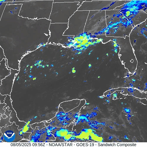
GOES-19 - Sector view: Gulf
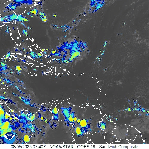
GOES-19 - Sector view: Caribbean
Florida Forecast
Highs: Near 90 °F with high humidity.
Afternoon thunderstorms: 40–50% chance from sea breeze activity.
Winds: Light and variable inland, shifting southeast near the coast.
No tropical storm impacts are expected today.
Rain forecast visualization courtesy of Windy.com
Prep Tip of the Day
Make sure your alert systems are working and up-to-date: test county-level emergency alerts, NOAA weather radios, and storm tracking apps. Confirm evacuation plans with household members and review where supplies are stored.
Outlook
Dexter poses no threat to land, but the tropical wave near Africa and Invest off the U.S. Southeast coast warrant close attention. August is historically when activity ramps up; conditions may become more favorable later in the week.
TL;DR – August 5 Snapshot
Tropical Storm Dexter weakening, drifting north but may reintensify offshore.
Two areas monitored: AL95 (30% chance) and African wave (~50% chance) for potential development.
SSTs remain warm, but SAL and wind shear continue to suppress many systems.
No tropical threats to Florida today—just typical summer storms.
Expect activity to increase as August progresses.
Stay ready and informed with daily updates at Cat5Prep.com.
Atlantic Hurricane Outlook – August 1, 2025: Quiet Tropics, Conditions Gradually Shifting
No storms expected as August begins, but multiple tropical waves are being tracked. Conditions are evolving and a shift toward higher hurricane activity is expected in the coming weeks.
*Those who like data, continue reading. Those it prefer the quick version, jump to the TL;DR here.
As we enter August—historically the onset of peak Atlantic hurricane activity—there are no active tropical cyclones and no development expected over the next seven days. However, several tropical waves are moving westward, and environmental conditions are slowly transitioning toward a more favorable pattern for storm formation later in the month.
Atlantic Basin Overview
According to the 8:00 AM EDT Tropical Weather Outlook (TWO) from the National Hurricane Center:
Tropical cyclone formation is not expected during the next 7 days WikipediaNational Hurricane Center
While no waves are currently listed as having development potential, multiple waves are traversing the eastern Atlantic.
Tropical Waves & Deep Tropics
Forecast models highlight several waves across the Atlantic, though none show organization yet:
A wave near 43–50°W, moving west at ~10–15 kt, producing scattered convection.
Another wave near 30°W, just moving off Africa, with intermittent thunderstorms.
These waves will be closely monitored as they enter warmer waters and encounter decreasing wind shear.
Environmental Conditions Snapshot
Sea Surface Temperatures (SSTs):
Gulf of Mexico & Caribbean: 29–31 °C (84–88 °F), sustaining high energy potential.
MDR: Slightly above-average values, but cooling compared to June trends .
Wind Shear:
Elevated across the Caribbean and central Atlantic—a limiting factor in early July—but gradual easing is forecast by mid-August.
Saharan Air Layer (SAL):
Persistent dry air suppressing convection across most of the MDR, but expected to weaken soon.
Atmospheric Moisture:
Enhanced moisture is slowly building in the western Atlantic, improving potential for organized convection.
Gulf of America (Mexico) & Caribbean Conditions
No disturbances are being tracked.
A dominant high-pressure ridge produces stable flow across both basins.
Offshore marine conditions remain calm, with scattered showers typical for this time of year.
Gulf of America (Mexico)
Caribbean
Florida Forecast
Highs: Low 90s °F, sticky and humid.
Precipitation: Scattered afternoon storms driven by afternoon heating and sea breeze convergence.
Winds: Light and variable inland, shifting southeast near the coast.
Rain forecast visualization courtesy of Windy.com
Prep Tip of the Day: Bookmark Tropical Outlook Sources
With activity still weeks away:
Confirm you can receive alerts from the National Hurricane Center.
Bookmark reliable sources such as Cat5Prep.com.
Ensure household members know where your hurricane documents and kits are stored.
Outlook
No cyclone formation is expected this week, but climatology and model trends suggest early-to-mid August could mark the beginning of increased tropical activity. The bulk of Atlantic season activity historically occurs after August 1, with the first hurricane typically forming around August 11.
TL;DR – August 1, 2025 Atlantic Forecast
No active or developing storms in the basin.
Several tropical waves tracked, none organized.
SSTs are warm; shear and SAL still suppressive.
A shift toward higher activity likely in early August.
Today is a good day to finalize hurricane plans and stay alert.

Atlantic Hurricane Outlook – June 17, 2025: Tropics Remain Quiet Despite Peak Heat
The Atlantic basin remains calm with no tropical storms in sight, despite record ocean heat and widespread Saharan dust. Forecasters continue monitoring subtle environmental shifts that could drive activity later this month.
The Atlantic basin remains clear today, with no active tropical cyclones and no tropical development expected over the next seven days, according to the National Hurricane Center’s 2 AM EDT outlook. Despite intense heating of sea surfaces, climatic factors are currently suppressing system formation.
Atlantic Basin: Calm, But Conditions Are Charged
No tropical cyclones or disturbances are being monitored. The Atlantic basin is experiencing what experts are calling an “unusual lull”—something highlighted recently by the Houston Chronicle, which also noted the ongoing Saharan dust presence suppressing early-season activity.
Satellite view via Windy.com
Sea Surface Temperatures: Fuel Ripe, But Storms Dormant
Gulf of America (Mexico) & Western Caribbean: Waters are hovering near 2°F above average, reaching 84–88°F, akin to early June 2024—an impressively warm baseline for storm development.
Main Development Region (MDR): Also experiencing above-average SSTs, laying the groundwork for future storm growth, though not yet fueling storms.
Sea Surface Temperature via Windy.com
Atmospheric Dynamics: Still Holding Back Storms

Wind Shear Courtesy of https://tropic.ssec.wisc.edu/
Wind Shear: Remains moderate to high, hindering storm organization across key regions.
Mid-Level Moisture: Slowly increasing, which may support thunderstorm development—but conditions remain insufficient for cyclones.
Saharan Dust Layer: A steady plume of Saharan air continues to suppress convection, reinforcing atmospheric stability across the Atlantic.
Saharan Air Layer (Dust) via Windy.com
Thunderstorm Activity: Local Showers Only
Florida and much of the Southeast will experience typical midday and afternoon thunderstorms driven by summer heat—not tropical systems. The Caribbean and Atlantic remain clear, with no signs of cluster formation or rotation.
Thunderstorm Forecast (ECMWF) via Windy.com
Florida Forecast (Statewide Conditions)
Highs: Upper 80s to low 90s °F (31–33 °C)
Humidity: Rising—classic early-summer humidity
Rain: Scattered afternoon storms likely, locally intense but short in duration
Visibility & Air Quality: Possible haze from Saharan dust in some southern counties
Winds: Light and variable, with stronger gusts near storm cells
Rainfall Forecast (ECMWF) via Windy.com
Prep Tip of the Day: Dust Alert and Kit Check
Today’s calm weather can hide hidden risks from dust and heat. Take action:
Improve indoor air quality: change HVAC filters and open windows carefully
Wear masks or stay indoors if sensitive to dust
Check your hurricane supplies and evacuation plans
Ensure NOAA Weather Radio and mobile alerts are operational
Bookmark trusted sites, like Cat5Prep.com and hurricanes.gov
Looking Ahead: Quiet Doesn't Mean Safe
No tropical development is expected in the next week, but climatological factors suggest the lull is temporary. Warm ocean temperatures and increasing moisture may spark storm formation later in June. Monitor daily updates as conditions evolve.

Atlantic Hurricane Outlook – June 4, 2025: A Flicker on the Horizon
Though no storms are active, key hurricane ingredients are aligning fast. A developing low near the Southeast U.S. and rising SSTs suggest change is coming.
The fourth day of the 2025 Atlantic hurricane season opens with quiet skies—but a subtle shift is underway. For the first time this season, the National Hurricane Center (NHC) has flagged a potential area of interest offshore the southeastern United States. While development chances remain low, it’s a reminder that conditions are evolving and the atmosphere is beginning to stir.

Atlantic Basin: A New Watch Zone Emerges
As of this morning’s Tropical Weather Outlook from the NHC:
No active tropical cyclones
One area of interest off the Southeastern U.S. coast
No tropical development expected in the next 48 hours
Low (10%) chance of development over the next 7 days
A non-tropical low pressure area is forecast to form near or offshore the Southeast U.S. coast.
If it remains offshore, it may gradually acquire subtropical or tropical characteristics while drifting northeastward at 10–15 mph.
— NHC Forecaster Reinhart, June 4, 2025
No storm is expected soon—but it’s the first official mention of potential development this season.
Satellite imagery courtesy of Windy.com
Sea Surface Temperatures: Ready for Action
Warm waters across the Atlantic basin continue to deepen—creating an ideal foundation for future storm formation:
Gulf of Mexico: Running 2–4°F above average, with pockets exceeding 86°F (30°C)
Western Caribbean: SSTs remain high, particularly around Central America and Cuba
Main Development Region (MDR): Trending warmer than normal with gradual warming expected into late June
This warm ocean water is the primary energy source for hurricanes—and it’s already in place.
Sea surface temperature data courtesy of Windy.com
Wind Shear & Moisture: Storm Barriers Continue to Erode
Atmospheric conditions are shifting in a storm-friendly direction:
Wind shear is weakening in key zones like the Gulf and Caribbean
Moisture levels are rising at both low and mid-levels of the atmosphere
Vertical instability is increasing, supporting larger, longer-lasting thunderstorms
This transition increases the likelihood that disorganized storms could become organized systems.

Wind Shear Courtesy of https://tropic.ssec.wisc.edu/
Saharan Air Layer: Still a Barrier, But Fading
A broad plume of Saharan dust remains in the central and eastern Atlantic, offering temporary protection:
Suppresses convection
Inhibits thunderstorm growth
Raises wind shear and dry air intrusion
However, models show this SAL influence weakening by mid-to-late June, removing one of the final natural inhibitors.
Saharan Air Layer data courtesy of Windy.com
Thunderstorm Activity: Early Clues
Even in the absence of tropical storms, convective activity gives us clues about what's forming:
Western Caribbean & Bay of Campeche: Disorganized clusters of thunderstorms show signs of persistent convection
Southeastern U.S. Coast: Isolated convection associated with the developing non-tropical low
While nothing is organizing yet, this pattern often precedes early-season development.
Thunderstorm data courtesy of Windy.com
Florida Forecast: Muggy Mornings, Stormy Afternoons
Expect typical summer conditions today across the state:
North Florida: Highs in the upper 80s, mostly sunny, low humidity
Central Florida: Around 90°F, with isolated thunderstorms after 2 PM
South Florida: Mid-80s, high humidity, with a greater risk of scattered PM storms
Afternoon thunderstorms are normal—but they also signal increasing moisture and instability across the region.
Forecast radar data courtesy of Windy.com
Prep Tip of the Day: Snap and Store
With one system on the radar, now’s a good time to check off a simple but essential task:
📸 Take photos of your home, car, and valuables
☁️ Back up those images to the cloud or email them to yourself
🔒 These photos may be critical for insurance documentation after a storm
Also:
Review your hurricane kit and evacuation plan
Sign up for emergency text alerts from local agencies
Bookmark trusted resources like Cat5Prep.com and hurricanes.gov
Looking Ahead: A Season Starting to Stir
It’s still early in the season, but we’re beginning to see motion on the map:
Warm water and shifting winds are laying the groundwork
The Saharan Air Layer is fading
Thunderstorm activity is creeping into critical regions
Today’s 10% chance of development is low—but it may mark the quiet season’s turning point.
We'll continue tracking changes in the Atlantic and bring you updated guidance each day.
Check back tomorrow for your next hurricane update from Cat5Prep.com.