
Atlantic Hurricane Outlook – August 19, 2025: Hurricane Erin holds as a powerful Category 3
TLDR Version: Click Here

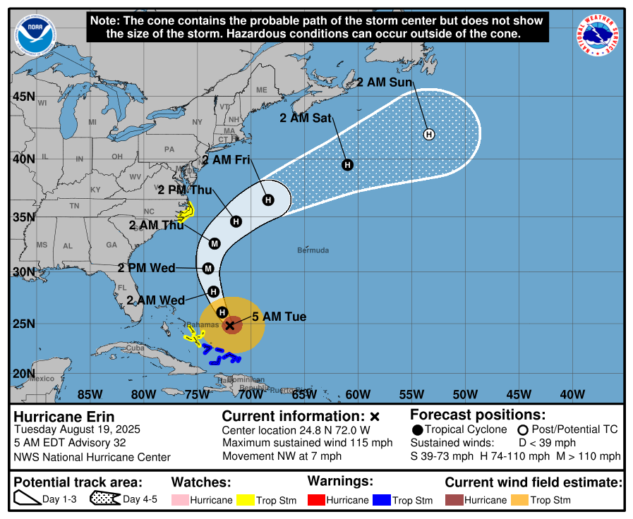
Hurricane Erin holds as a powerful Category 3; Life-threatening surf and flooding are poised to impact the East Coast
Hurricane Erin, now a Category 3 system with sustained winds near 115 mph, continues its path just east of the Bahamas. While a U.S. landfall remains unlikely, significant coastal impacts are unfolding. Meanwhile, the Gulf of Mexico and Florida remain calm.
Atlantic Basin Overview
Hurricane Erin (Cat 3): Sustained winds are approximately 115 mph. The storm remains offshore, shifted slightly northwest, and continues to drive dangerous surf and rip currents from Florida through New England. Forecasters warn of coastal flooding, storm surge, and beach erosion—especially across the Outer Banks, where evacuation orders are in effect. Waves are expected to reach 15–25 feet, with minor to moderate flooding along the Mid-Atlantic coast. Erin feels the effects of a prior eyewall replacement cycle and is now in a weakening trend influenced by increased shear and dry air.
Other Atlantic systems: No immediate new tropical cyclones are expected. The National Hurricane Center continues to monitor waves and disturbances, but environmental conditions (dry air, wind shear) remain inhibiting.


Gulf of America (Mexico)
Quiet and stable: There are no organized systems. Activity is limited to isolated afternoon convection along the Gulf Coast, tied to heat-driven storm patterns rather than tropical development.
Florida & Southeast U.S. Outlook
Florida Peninsula: Expect routine summertime weather—afternoon thunderstorms fueled by sea breezes. No tropical threats are anticipated.
East Coast (NC to FL): Erin's long-period swells are arriving along coastal areas, raising rip current and surf hazards significantly. Beachgoers must exercise caution, and lifeguard advisories should be strictly followed.
Rain forecast visualization courtesy of Windy.com
Environmental Conditions
Sea Surface Temperatures (SSTs): Remain warm—aiding Erin’s sustained intensity and surf generation.
Wind Shear & Moisture: Increasing shear and dry air are contributing to Erin’s gradual weakening and restraining new development elsewhere in the basin.

TL;DR – August 19 Snapshot
Erin downgraded to Category 3; offshore path continues; U.S. threats are limited to surf, rip currents, and coastal flooding.
Outer Banks under evacuation orders due to expected flooding and beach erosion.
Florida and Gulf: Calm, with routine afternoon storms and no new tropical systems.
Stay alert on the coasts: Dangerous marine conditions ahead—especially from North Carolina to Florida.