

Atlantic Hurricane Outlook – June 12, 2025: Dusty Skies, Quiet Tropics
The Atlantic basin remains quiet with no tropical activity expected over the next week. Strong Saharan dust suppresses storm development and reduces air quality across Florida, but warming waters and easing wind shear hint at increased hurricane potential later in June.
As we move through the second week of the Atlantic hurricane season, the basin remains quiet. There are no active tropical cyclones, no areas of interest, and no expected development over the next 7 days, according to the National Hurricane Center’s 2 AM EDT outlook. While this calm is typical for early June, forecasters are keeping an eye on evolving conditions that could shift toward tropical development later this month.
Atlantic Basin: Still and Stable
No tropical systems are on the map, and the 7-day outlook remains clear. The Atlantic basin continues its quiet streak, consistent with climatology for early June. However, this calm will not last forever, and underlying signals suggest more favorable conditions could emerge by late June or early July.
Satellite image courtesy of Windy.com
Sea Surface Temperatures: Warm and Ready
Ocean waters across the Atlantic basin are trending warm, offering potential fuel for future storms.
Gulf of America (Mexico): Low to mid-80s°F (28–30°C), above average in many spots.
Western Caribbean: Warm and supportive of tropical development later in the season.
Main Development Region (MDR): Warmer than normal for this time of year, laying the groundwork for long-track systems from Africa.
Sea surface temperature data courtesy of Windy.com
Atmospheric Conditions: Slowly Trending Toward Favorable
While the Atlantic remains quiet, the atmosphere is showing signs of gradual change.
Wind Shear remains moderate to high across parts of the Caribbean and central Atlantic, still limiting storm formation. However, global models suggest a slow reduction in shear over the coming weeks.
Mid-level moisture is increasing across the Caribbean and Gulf—helpful for deep convection and thunderstorms.
These subtle shifts are typical precursors to an uptick in tropical activity as the season matures.

Wind Shear Courtesy of https://tropic.ssec.wisc.edu/
Saharan Air Layer: Strong and Dusty
A massive plume of Saharan dust is stretching across the Atlantic and reaching Florida and the Gulf Coast today.
The dry air and strong upper-level winds associated with the Saharan Air Layer (SAL) are suppressing tropical development.
This dust layer is also reducing air quality and visibility in parts of Florida and the Southeast, especially for those with respiratory conditions.
The SAL is expected to remain dominant into mid-to-late June before it begins to weaken.
Dust/SAL data courtesy of Windy.com
Thunderstorm Activity: Mostly Local and Non-Tropical
Convective activity across the Atlantic basin is minimal and disorganized.
Florida: Hazy skies and isolated afternoon thunderstorms are expected, but nothing tropical in nature.
Western Caribbean and Off the U.S. East Coast: Scattered showers remain unorganized.
Thunderstorm data courtesy of Windy.com
Florida Forecast: Dusty Skies, Humid Air
Highs: Upper 80s to low 90s°F (31–33°C)
Skies: Hazy due to Saharan dust
Rain Chances: Scattered PM thunderstorms possible
Air Quality: Reduced in some areas—sensitive groups should take precautions
Winds: Light and variable
Rain data courtesy of Windy.com
Prep Tip of the Day: Protect Your Lungs and Finalize Your Plan
Use the quiet to finalize your hurricane prep, especially while dusty skies dominate:
Limit outdoor activity if you’re sensitive to dust or pollen
Replace or clean air filters in your home and car
Check that your family communication plan and evacuation routes are up to date
Store key websites in your browser bookmarks: hurricanes.gov, Cat5Prep.com
Looking Ahead: The Table Is Being Set
While the tropics are calm today, the pieces are slowly moving into place for increased activity later this month. Warm waters, a gradual easing of wind shear, and rising moisture hint at a more active pattern on the horizon. Stay vigilant, and check back daily for updates.

Atlantic Hurricane Outlook – June 11, 2025: Quiet Tropics Continue Amid Rising Possibilities
he Atlantic basin remains calm on June 11, 2025, with no tropical storms or disturbances expected over the next week. However, warming sea surface temperatures and easing atmospheric barriers hint at increased hurricane activity later this month. Stay prepared with daily updates from Cat5Prep.com.
The twelfth day of the 2025 Atlantic hurricane season opens with calm conditions—no tropical storms, depressions, or areas being actively monitored. According to the National Hurricane Center (NHC), no tropical cyclone formation is expected over the next seven days. The basin remains in an early-season lull, but the combined presence of warm water and easing atmospheric barriers demands continued attention.

Atlantic Basin: Clear Today, But Shifts Are Underway
Active Systems: Zero
Disturbances: None
Tropical Formation Outlook: No development expected through June 18, 2025.
This state of inactivity is consistent with early June climatology. Still, meteorologists point out that subtle environmental shifts are in motion beneath the surface.
Satellite imagery courtesy of Windy.com
Sea Surface Temperatures: A Growing Foundation
Gulf of America (Mexico) & Western Caribbean: Steady low- to mid‑80s °F (27–29 °C), ideal for fuel if storms form
Main Development Region (MDR): Sea surface temperatures are trending above normal for early June
These warm waters persist as a critical energy reserve for potential fast-moving tropical systems.
Sea surface temperature data courtesy of Windy.com
Wind Shear & Moisture: Gradual Improvements
Wind Shear: Moderate to high across much of the basin, suppressing storm development
Moisture: Midlevel humidity is slowly climbing in the Gulf and Caribbean—supporting the formation of deeper convection
This evolving balance suggests the atmosphere may be priming for tropical cyclones in the coming weeks.

Wind Shear Courtesy of https://tropic.ssec.wisc.edu/
Saharan Air Layer: A Continuing Deterrent
An active plume of Saharan dust covers the central and eastern Atlantic, suppressing convection and reinforcing vertical wind shear
This protective layer is expected to weaken by late June, enabling better conditions for tropical wave development
Saharan Air Layer (SAL) data courtesy of Windy.com
Thunderstorm Activity: Local, Non-Tropical
Florida & Southeast U.S.: Expect isolated afternoon storms—standard for this time of year
Western Caribbean: A few clusters of showers persist but remain disorganized
Central Atlantic: Remains convection-free with no signs of tropical wave development
Thunderstorm data courtesy of Windy.com
Florida Forecast (Statewide)
Highs: Upper 80s to low 90s °F (31–33 °C)
Humidity: Moderate to high—classic muggy summer conditions
Rain: Scattered midday and afternoon thunderstorms
Winds: Light and steady
Rainfall data courtesy of Windy.com
Prep Tip of the Day: Check NOAA Weather Radio
Take advantage of quiet skies to:
Test your NOAA Weather Radio
Confirm you are signed up for mobile and text alert services
Ensure your emergency gear is functional and accessible
Staying alert now reduces stress later.
Looking Ahead: Remain Alert, Not Alarmed
While no tropical formations are expected through June 18, the convergence of:
Persisting warm SSTs
Weakening wind shear
And waning Saharan dust
set the stage for increased activity during the latter half of June.
Stay connected to Cat5Prep.com for your daily update and tracking as the tropical season progresses.

Atlantic Hurricane Outlook – June 9, 2025: Tropical Tranquility Continues
No storms are expected this week as the Atlantic hurricane season stays quiet. Warm waters and shifting wind patterns suggest activity could increase later in June. Stay prepared with today’s full update.
The ninth day of the 2025 Atlantic hurricane season dawns with quiet conditions—no active storms or signs of tropical development are present. The National Hurricane Center (NHC) confirms that no tropical cyclone formation is expected in the Atlantic Basin over the next seven days. It's a typical early-June lull, but with warming waters and shifting atmospheric dynamics, conditions may change quickly.
Atlantic Basin: Clear Skies, No Areas of Concern
No active tropical cyclones
No disturbances or systems being monitored
7-day outlook shows no development expected
This continued calm aligns with seasonal norms—but forecasters are keeping a cautious eye on the evolving environment.
Satellite imagery courtesy of Windy.com
Sea Surface Temperatures: Warm and Watchful
Gulf of America (Mexico) & Western Caribbean: Sea surface temperatures remain in the low‑to‑mid‑80s °F (27–29 °C), sufficient to fuel tropical systems.
Main Development Region (MDR): SSTs are gradually rising, though not yet at peak summer levels.
These ongoing warm waters provide a key energy source for future storm formation.
Sea Surface Temperature (SST) data courtesy of Windy.com
Atmospheric Conditions: Still Mixed, Not Conducive
Wind Shear: Moderate to high shear persists, particularly in western Caribbean and central Atlantic—suppressing thunderstorm organization.
Moisture Levels: While mid-level atmospheric moisture is increasing, it's not yet sufficiently abundant or widespread to support cyclone development.
Together, these factors continue to limit tropical activity.
Wind Shear Courtesy of https://tropic.ssec.wisc.edu/
Saharan Air Layer: A Persistent Block
A strong plume of dry, dusty Saharan air remains entrenched over the central and eastern Atlantic.
This Saharan Air Layer (SAL) injects dryness and wind shear that further inhibit storm formation.
Expect suppression to continue into mid-June when SAL influence typically begins to decline fox35orlando.com.
Saharan Air Layer (Dust) data courtesy of Windy.com
Thunderstorm Activity: Routine, Non-Tropical
Florida & Southeast U.S.: Scattered afternoon storms—typical for early June.
Western Caribbean: A few isolated, disorganized cells persist, but show no signs of development.
Eastern Atlantic: Quiet and without organized convection.
These systems are seasonal and not related to hurricane development.
Thunderstorm data courtesy of Windy.com
Florida Forecast (All Regions)
Highs: Upper 80s to low 90s °F (31–33 °C)
Humidity: Moderate to high, creating a muggy atmosphere
Rain: Isolated to scattered afternoon and evening storms
Winds: Light and variable
A classic early-summer day with palm trees swaying but no storm threats.
Rainfall forecast courtesy of Windy.com
Prep Tip of the Day: Review Evacuation Plans
Use this calm window to double-check your evacuation readiness:
Reconfirm your evacuation zone and route.
Update your household emergency plan, including pets and special needs.
Keep contact numbers accessible, especially local officials and emergency services.
Test your NOAA weather radio and ensure alerts are activated on mobile devices.
Looking Ahead: Still Calm, But Eyes Remain Open
No tropical development is forecast this week, but the environment is slowly warming and becoming more favorable:
Warm water concentrations persist
Wind shear may decrease in the coming weeks
Moisture levels are increasing regionally
While it's still quiet, conditions are edging toward potential activity. Continue to check in daily for updates as Cat5Prep.com monitors the evolving season.
Atlantic Hurricane Outlook – June 3, 2025: Conditions Ripening Beneath the Calm
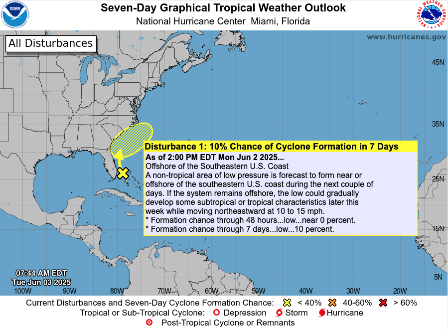
The 2025 Atlantic hurricane season starts quietly, but today, June 3, 2025, the National Hurricane Center identifies a new low-pressure area off the Southeastern U.S. coast. Conditions are slowly becoming more favorable for storm development this week.
The third day of the 2025 Atlantic hurricane season begins much like the last—quiet skies and no named systems. But meteorologists are watching closely. While there are no storms on the map, the ingredients for tropical cyclone formation are slowly assembling. Sea surface temperatures are rising, atmospheric inhibitors are weakening, and thunderstorm activity is beginning to build in key regions. It’s still early—but don’t get too comfortable.
Atlantic Basin: New Area of Interest and Overall Quiet
As of yesterday afternoon’s update from the National Hurricane Center (NHC), a new area of low pressure has been identified just off the southeastern United States coast:
A non-tropical area of low pressure is expected to form near or offshore of the southeastern U.S. coast in the next couple of days.
If it remains offshore, it could gradually acquire subtropical or tropical characteristics later this week while tracking northeastward at 10 to 15 mph.
Formation chance through 48 hours: Low (near 0%)
Formation chance through 7 days: Low (10%)
While development is currently unlikely, this is the first flagged area of interest in the Atlantic this season — a reminder that conditions are slowly trending more favorable. Models will continue to be monitored for any shifts in track or intensity.
At this time, no direct impacts are expected for the U.S. mainland, but boaters and beachgoers along the Southeast Coast should monitor local marine conditions later this week.
Otherwise, the basin remains quiet:
No active tropical cyclones
No other areas of interest
No tropical development expected in the next 7 days
A quiet start like this is typical for early June but it’s not a signal to let your guard down. The long-range outlook hints at increasing activity potential by mid-to-late June, especially in the western Caribbean and Gulf of America (Mexico).
Satellite imagery courtesy of Windy.com
Sea Surface Temperatures: Storm Fuel Is Already in Place
Warm waters are the engine that powers hurricanes, and the Atlantic is already running hot:
Gulf of America (Mexico): 2–4°F above average, with widespread 86°F+ (30°C) readings
Western Caribbean: Elevated SSTs continue to build near Central America and Cuba
Main Development Region (MDR): Trending warmer than normal, with the potential to support long-track storms later this season
These above-average temperatures are primed to support rapid intensification once storm systems begin to form.
Sea surface temperature data courtesy of Windy.com
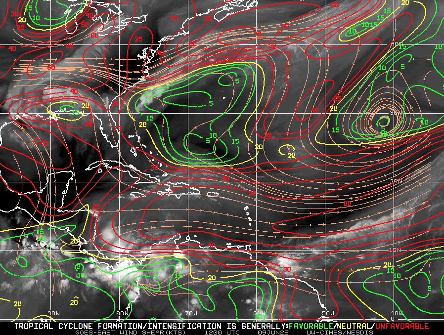
Wind Shear & Moisture: A Shifting Balance
Wind shear—the atmospheric force that disrupts hurricane development—is weakening, especially in the Caribbean and Gulf. At the same time, moisture levels in the lower and mid-atmosphere are rising.
This combination supports stronger thunderstorms and vertical cloud development—key precursors for tropical formation.
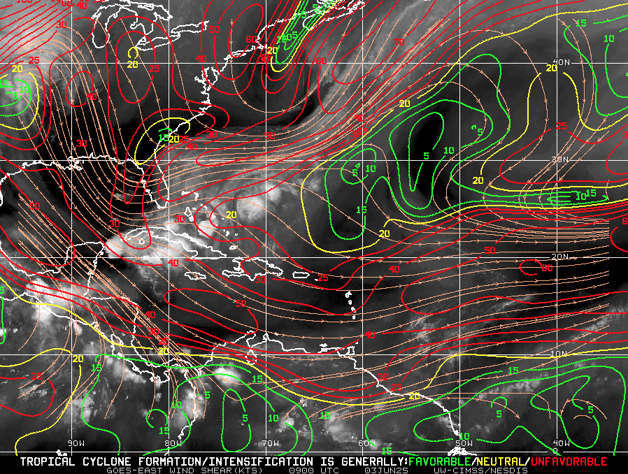
Wind-shear Map Image Courtesy of : https://tropic.ssec.wisc.edu/
Saharan Air Layer: Dust Is Holding Steady—for Now
A broad stretch of the Saharan Air Layer (SAL) is still active across the central and eastern Atlantic:
Dry, stable air disrupts tropical wave development
Increased wind shear limits vertical convection
Dust particles reduce storm cloud organization
While the SAL continues to offer some protection in the eastern Atlantic, it’s expected to weaken later this month—removing one of the last early-season barriers to storm growth.
Satellite dust data courtesy of Windy.com
Thunderstorm Activity: Not Just Summer Weather
While today’s thunderstorms aren’t tropical, their growing presence is important:
Western Caribbean: Clusters of convection are forming, though currently disorganized
Southeastern U.S. & Gulf Coast: Expect afternoon storms, fueled by heat and humidity
These storm systems help prime the atmosphere for eventual tropical development and are often the earliest signs of areas of interest.
Thunderstorm data courtesy of Windy.com
Florida Forecast: A Classic, Stormy Summer Day
Expect another typical early June day across the Sunshine State:
North Florida: Upper 80s, low humidity, mostly clear
Central Florida: Around 90°F with building humidity and scattered PM storms
South Florida: Mid-80s, muggy, with increased chances of storms after 2 PM
Though today’s storms are not tropical, the overall pattern is signaling a slow seasonal transition.
Forecast radar imagery courtesy of Windy.com
Prep Tip of the Day: Get Ahead While It’s Quiet
This calm window is the perfect time to prepare:
Review your hurricane plan and local evacuation routes
Restock your hurricane kit—especially water, batteries, and medications
Take photos of your home and valuables for insurance
Sign up for local emergency alerts and bookmark Cat5Prep.com
Know the difference between a watch and a warning before one is issued
Looking Ahead: No Storms Now, But Don’t Let That Fool You
Though nothing is spinning in the Atlantic today, all signs point to rising potential in the weeks ahead. Sea temperatures are already warm enough to support hurricanes. Wind shear is fading. Moisture and thunderstorm activity are increasing.
We are not forecasting imminent development—but the environment is evolving fast.
Check back tomorrow for your daily hurricane update from Cat5Prep.com.

Atlantic Hurricane Outlook – June 2, 2025: A Quiet Morning, But Don’t Get Comfortable
June 2, 2025 Atlantic hurricane update: Calm skies for now, but unusually warm sea surface temperatures and shifting atmospheric conditions could spark activity later this month. Stay prepared with the latest forecasts and safety tips.
The second day of the 2025 Atlantic hurricane season begins under calm skies, but seasoned forecasters know better than to be lulled by the stillness. With sea temperatures running hot and atmospheric patterns shifting toward favorability, this quiet start may not last long.
Atlantic Basin: All Clear—For Now
As of this morning’s update from the National Hurricane Center (NHC), there are no active tropical cyclones, no areas of interest, and no tropical development expected over the next seven days.
This early-season lull is common in the first half of June, but warm waters and waning atmospheric inhibitors are quietly setting the stage for activity later this month.
Satellite data courtesy of Windy.com
Ocean Heat: The Hidden Fuel Source
Sea surface temperatures (SSTs) across the Atlantic basin are unusually high for this time of year—creating the potential for rapid storm intensification when development does occur:
Gulf of America (Mexico): Running 2–4°F above average, with large swaths above 86°F (30°C)
Caribbean Sea: Above-average temperatures, especially in the western basin
Main Development Region (MDR): Continuing to trend hot
Warm water is the engine that powers tropical cyclones, and the basin is already running well above operating temperature.
Sea surface temperature (SST) data courtesy of Windy.com
ENSO Status: La Nada Means No Safety Net
The El Niño–Southern Oscillation (ENSO) remains in a neutral phase, a state meteorologists often refer to as "La Nada."
El Niño has ended, removing the high wind shear that often suppresses Atlantic hurricanes
La Niña has not yet begun, but conditions may be trending in that direction later this summer
Neutral ENSO removes large-scale inhibitors, allowing the Atlantic to operate unchecked
Historically, neutral ENSO years correlate with average to above-average tropical storm activity.
Wind data courtesy of Windy.com
Saharan Air Layer: Dust Still Offers a Buffer—for Now
The Saharan Air Layer (SAL) continues to stretch across the tropical Atlantic, providing a temporary shield against storm formation:
Introduces dry, stable air into the atmosphere
Inhibits convection and cloud development
Increases wind shear in the central Atlantic
The SAL typically weakens by late June, making it easier for tropical waves to grow and organize.
Saharan Air Layer (SAL) dust data courtesy of Windy.com
Florida Forecast: A Summer Day with a Side of Humidity
Today’s conditions across Florida reflect typical early-June weather:
North Florida: Highs in the upper 80s, low humidity, and mostly sunny skies
Central Florida: Highs around 90°F, building humidity, and isolated afternoon storms
South Florida: Warm and muggy with highs in the mid-80s and a greater chance of scattered storms after 2 PM
It’s a classic Florida day—but the kind that often precedes the real tropical drama in July and August.
Weather radar forecast data courtesy of Windy.com
Prep Tips: Take Advantage of the Calm
With no storms on the map, today is a perfect day to prepare:
Review your hurricane plan and evacuation routes
Restock your hurricane kit
Double-check home insurance coverage
Take photos of property and valuables
Sign up for local emergency alerts
Bookmark trusted sources like Cat5Prep.com and the National Hurricane Center
Looking Ahead: Eyes on the Tropics
We remain in a short-term window of calm, but all indicators suggest that activity will ramp up in the coming weeks. Record-breaking sea surface temperatures and favorable upper-atmospheric trends point to early-season development potential later in June.
Stay alert. Stay ready. And check back tomorrow for your next update from Cat5Prep.

*As an Amazon Associate, we earn from qualifying purchases.

Atlantic Hurricane Outlook – June 1, 2025: Opening Day, But All’s Quiet… For Now
June 1 marks the official start of the 2025 Atlantic hurricane season. No storms are currently active, but rising sea surface temperatures and favorable patterns suggest a potentially busy season ahead.
The Atlantic hurricane season officially begins today, June 1, and while the tropics are currently quiet, forecasters are already eyeing the environmental conditions that could lead to a very active season. For residents in hurricane-prone regions, now is the time to prepare—not relax.
Atlantic Basin: Calm Start to the Season
As of the latest update from the National Hurricane Center (NHC), there are no active tropical systems, no areas of concern, and no immediate threats expected over the next seven days.
This quiet opening is not unusual. Early June often sees little activity in the deep tropics. However, this calm is not expected to last. Sea surface temperatures are running well above average, and the atmospheric setup is trending toward conditions favorable for development later this month.
Satellite data courtesy of Windy.com
Sea Surface Temperatures: Running Hot
The Atlantic basin is notably warm for this early in the season, providing more than enough fuel for potential tropical cyclones.
Gulf of America (Mexico): 2 to 4°F above normal, with widespread areas exceeding 86°F (30°C)
Caribbean Sea: Similar temperature anomalies, especially in the western basin
Main Development Region: Continues trending above average
Historically, warmer-than-average waters correlate with more frequent and intense storms.
Sea surface temperature data courtesy of Windy.com
ENSO Neutral: La Nada Takes Over
The El Niño–Southern Oscillation (ENSO) is now in a neutral phase. With El Niño in the rearview and La Niña not yet in play, we enter what meteorologists call "La Nada"—a neutral state that often removes inhibiting influences on hurricane formation.
Decreased wind shear is expected across the Atlantic basin
A neutral ENSO often correlates with average to above-average storm development
Other patterns, like the Madden–Julian Oscillation (MJO), may become more influential later in the month
Saharan Air Layer: Dust Still in Play
The Saharan Air Layer (SAL) continues to stream across the Atlantic from Africa, bringing with it dry, dusty air that temporarily suppresses tropical development.
Inhibits cloud formation and convection
Increases atmospheric stability
Introduces vertical wind shear
The SAL typically begins to weaken later in June, removing one of the key atmospheric barriers to tropical development.
Saharan Dust SAL data courtesy of Windy.com
Eastern Pacific: Alvin Weakens
Tropical Storm Alvin, the Eastern Pacific's first named storm of the season, formed earlier this week and is now weakening.
Location: Approximately 710 miles south of Baja California
Movement: Northwest at 13 mph
Maximum Winds: 50 mph, weakening
Forecast: Expected to dissipate within 36 hours
Though Alvin poses no threat to land, its formation signals that tropical systems are beginning to stir in the broader region.
Alvin wind accumulation in Eastern Pacific data courtesy of Windy.com
Florida Forecast: Statewide Conditions Typical for June
Across the state of Florida, today's weather reflects classic early summer patterns.
North Florida: Highs in the upper 80s, lows in the mid-60s, low humidity, mostly clear skies
Central Florida: Highs near 90°F, afternoon humidity and a slight chance of thunderstorms
South Florida: Highs in the mid-80s, lows in the upper 70s, muggy with isolated afternoon storms
These are the kinds of conditions that typically precede the onset of more frequent tropical activity in late June and July.
Temperature across Florida data courtesy of Windy.com
Preparation Tips: Start Now, Not Later
With the season now officially underway, take time today to prepare while skies are still clear.
Review your family emergency plan and evacuation zone
Check and restock your hurricane kit
Confirm your insurance coverage and take property photos
Sign up for local emergency alerts and follow trusted forecast sources
Bookmark Cat5Prep.com and the National Hurricane Center
Looking Ahead
Although the season begins on a quiet note, forecasters warn that this calm is likely temporary. Record sea surface temperatures, a neutral ENSO, and easing wind shear all point to increased tropical activity as we move deeper into June.
Stay ready, stay informed, and check back daily for new updates from Cat5Prep.

*As an Amazon Associate, we earn from qualifying purchases.