
Atlantic Hurricane Outlook – August 2, 2025: Watching Waves, But No Storms Expected
The Atlantic remains calm to start August, with no storms expected this week. A few tropical waves are being monitored, but dry air and wind shear continue to suppress development—for now.
*Those who like data, continue reading. Those it prefer the quick version, jump to the TL;DR here.
As we settle into early August, the Atlantic remains quiet—no active tropical systems and no development forecasted over the next seven days. Although several tropical waves continue moving westward, persistent upper-level wind shear and Saharan dust limit their potential for organization.
Atlantic Basin Summary
Latest NHC Tropical Weather Scales:
The 8 AM EDT Tropical Weather Outlook confirms no systems expected to form within seven days.
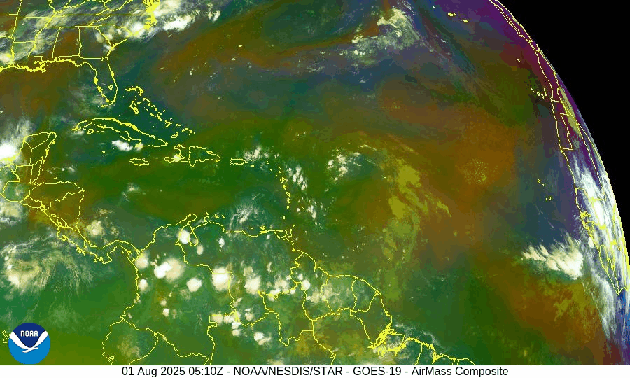
Multiple tropical waves are active:
A wave near 43–50°W with scattered convection.
A new wave moving off Africa near 30°W, gradually tracking westward.
None display organized circulation or development potential at this time.
Satellite imagery provided by Windy.com
Environmental Conditions
Sea Surface Temperatures (SSTs):
29–31 °C (84–88 °F) across the Gulf of Mexico and Caribbean.
MDR temperatures remain slightly above average, offering rising energy for late-season storms.
Wind Shear:
Still moderate to high across much of the basin, inhibiting vertical growth.
Saharan Air Layer (SAL):
Thick dry air layer continues across most of the MDR, suppressing convection and storm development.
Atmospheric Moisture:
Gradually increasing in the western Atlantic and Caribbean—monitoring for signs of improved convective support.
Gulf of America (Mexico) & Caribbean Region
No disturbances currently monitored.
A dominant high-pressure ridge maintains light winds and calm seas.
Scattered showers along Florida’s west coast remain typical summer moisture—not tropical in origin.
Radar imagery courtesy of Windy.com
Florida Forecast
Highs: Upper 80s to low 90s °F with high humidity.
Rain Chances: 40–50% for scattered afternoon thunderstorms due to seabreeze convergence.
Winds: Light and variable.
No tropical threats expected in Florida today.
Rain forecast visualization courtesy of Windy.com
Seasonal Outlook
The Atlantic season to date includes three named storms (Andrea, Barry, and Chantal), but lacks any hurricanes—a below-average ACE, echoing early-season inactivity last seen in 2009.
NOAA and CSU continue to forecast above-average hurricane activity overall, with 13–19 named storms and 6–10 hurricanes anticipated this season.
August typically marks the ramp-up of tropical activity, especially across the MDR and Gulf of Mexico, where conditions may become more favorable by mid-month.
Prep Tip of the Day: Verify Your Alert Setup
Now is a good time to:
Confirm you’re registered with local emergency alert systems.
Test NOAA weather radios and app notifications.
Re-check family communication plans and emergency kit locations.
Looking Ahead
While the forecast remains calm now, early August often brings the first major shifts in seasonal activity. Keep tracking tropical waves as they approach warmer waters and potentially lower shear environments.
TL;DR – August 2, 2025 Hurricane Summary
No active storms or developing systems in the Atlantic.
Several tropical waves are present but remain weak and disorganized.
High wind shear and Saharan dust continue to suppress development.
Sea surface temperatures are high and rising.
Historical patterns suggest increased activity may begin in mid‑August.
Stay prepared and stay informed with daily updates from Cat5Prep.com.

Atlantic Hurricane Outlook – July 30, 2025: Development Chances Remain Low
As July ends, the Atlantic Basin sees active tropical waves, but development chances remain low for the next 7 days. Discover the latest on sea surface temperatures, wind shear, Saharan Air Layer, and the outlook from CAT5Prep.com.
*Those who like data, continue reading. Those it prefer the quick version, jump to the TL;DR here.
** Due to technical issues on the GOES satellite imagery provider's end, we are currently unable to display real-time satellite imagery.
The Atlantic Basin remains active with multiple tropical waves stretching from the African coast to the Caribbean, yet no organized development is expected in the near term. Wind shear and Saharan dust continue to suppress cyclone formation despite warm ocean temperatures and a moistening atmosphere in the western basin.
As we close out July, conditions are slowly trending toward a more favorable setup for storm development heading into August.
Atlantic Basin Overview
As of the 8:00 AM EDT NHC Tropical Weather Outlook:
No active tropical cyclones.
Three tropical waves span the Atlantic:
Wave near 35°W (eastern Atlantic): Disorganized, little convection.
Wave near 50°W (central Atlantic): Producing scattered thunderstorms, no surface low.
Wave in the eastern Caribbean: Weak and encountering dry air and shear.
NHC Development Odds:
Next 48 hours: 0%
Next 7 days: 0%
Key Environmental Factors
SST data courtesy of Windy.com
Wind data at 850hPa from Windy.com
Sea Surface Temperatures (SSTs):
29–31°C (84–88°F) in the Gulf of Mexico and Caribbean.
MDR remains slightly warmer than normal.
Wind Shear:
Moderate across the central Atlantic and Caribbean.
Suppressing vertical development for now.
Saharan Air Layer (SAL):
Strong dry air across much of the basin.
Limiting convection and keeping tropical waves disorganized.
Moisture:
Gradually increasing in the western Atlantic and Caribbean.
A factor to monitor as wind shear begins to ease.
Gulf of Mexico (Gulf of America)
A weak surface trough in the central Gulf is producing scattered showers and isolated thunderstorms.
No signs of organization, and the NHC does not expect development at this time.
High pressure remains dominant elsewhere, with calm conditions expected through midweek.
Florida Weather
Highs in the upper 80s to low 90s with high humidity.
Scattered thunderstorms possible in the afternoon and evening from sea breeze interactions.
No tropical threats to Florida at this time.
Radar imagery courtesy of Windy.com
Outlook & Preparedness
The Atlantic remains broadly quiet for now, but the environment is slowly shifting. A steady wave train emerging off Africa and increasingly favorable SSTs point to a more active window in early to mid-August.
Now is the time to double-check hurricane kits, review evacuation zones, and prepare while the weather allows.
TL;DR – July 30 Snapshot
No tropical development expected this week.
Three tropical waves are present but remain weak and disorganized.
SAL and shear are limiting development.
Conditions should become more favorable by early August.
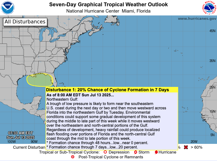
Atlantic Hurricane Outlook – July 13, 2025: Tropics Quiet, Gulf Trough Under Watch
No named storms today, but a low-pressure trough drifting toward the Gulf of Mexico could bring rain and potential tropical development later this week.
The Atlantic basin remains calm today, with no active named storms. However, meteorologists are tracking a low-pressure trough emerging off the Southeast U.S. coast, gradually drifting into the Gulf of Mexico. This system has a low (20%) chance of organizing into a subtropical or tropical system later this week .
Atlantic Overview: Quiet But Evolving
As per the 8 AM EDT NHC Tropical Weather Outlook:
No active tropical cyclones across the basin.
The Southeast U.S. trough is expected to push into the Gulf by Tuesday.
Formation chances: <1% in next 48 hours, ~20% over 7 days .
Though not tropical now, its movement may increase rainfall and raise attention if organization begins.
Satellite view via Windy.com
Sea Surface Temperatures: A Warm Platform
The Gulf of Mexico continues to show SSTs 2–4°F above average, providing a warm environment for storm development later this season.
Caribbean and Main Development Region (MDR) SSTs also remain elevated, keeping hurricane fuel accessible .
Sea Surface Temperature via Windy.com
Atmospheric Setup: Suppression in Play

Wind Shear Courtesy of https://tropic.ssec.wisc.edu/
Wind shear remains moderately strong across much of the basin, hindering storm development.
Saharan dust is still prevailing over the eastern Atlantic, suppressing early-season storm growth.
Moisture levels are slowly increasing in the Gulf and Southeast U.S., signaling gradual support for convection.
Saharan Air Layer (Dust) via Windy.com
Regional Weather: Rain on the Rise
Expect increased showers and thunderstorms along the Southeast U.S. and Gulf coasts as the trough approaches.
Florida will likely see scattered afternoon storms, typical for July, especially as the trough draws moisture inland.
Thunderstorm Forecast (ECMWF) via Windy.com
Prep Tip of the Day: Be Rainwise
Even without strong winds, heavy rainfall can pose serious hazards:
Track the trough’s movement—it could bring localized flash flooding to Gulf coast areas.
Ensure storm drains and sump pumps are clear and functional.
Keep sandbags and quick barriers ready if you're in low-lying zones.
Test your NOAA Weather Radio and mobile alerts to stay ahead of rainfall warnings.
Looking Ahead: Waters Stay Warm—Storms Could Spark
Although the tropics are peaceful now, the combination of warm ocean temperatures, easing atmospheric inhibitors, and growing seasonal moisture suggest readiness for evolution. The trough may serve as the first spark of Gulf activity, with a watchful eye needed through mid- to late-week.
Stay alert and check back tomorrow for your latest update from Cat5Prep.com.