

Atlantic Hurricane Outlook – August 12, 2025: Tropical Storm Erin Strengthens; Gulf & Florida Remain Calm
Tropical Storm Erin strengthens in the eastern Atlantic with hurricane potential, while the Gulf of Mexico and Florida remain calm. Here’s today’s August 12, 2025 hurricane update.
TLDR Version; Click Here
Tropical Storm Erin, the fifth named storm of the 2025 season, has formed and is steadily intensifying in the eastern Atlantic. No tropical systems are currently threatening U.S. coastlines, but the atmosphere is becoming more favorable for additional activity later in the week.
Atlantic Basin Summary
Tropical Storm Erin is centered roughly 560 miles west-northwest of the Cabo Verde Islands, moving west at 22 mph with sustained winds near 45 mph. Models suggest Erin could strengthen into a hurricane within the next few days and potentially become the season’s first major hurricane. Forecasters anticipate a gradual curve to the northwest later in the week, keeping land impacts unlikely for now.
While Erin organizes, no other significant systems are expected to develop across the Atlantic this week, though other waves are being monitored as conditions continue to evolve.
GEPS Track Model for TS Erin August 12, 2025
GEFS Track Model for TS Erin August 12, 2025
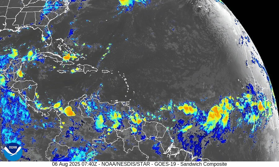
Gulf of America (Mexico) & Caribbean Conditions
Gulf of America (Mexico): Stable weather with no tropical threats. Sea surface temperatures remain elevated—around 2°F above average in early August —but without supportive atmospheric dynamics for development.
Caribbean Sea: General trade wind flow continues, with only typical convective activity. No organized disturbances are present.
GOES - GULF Sandwich August 12, 2025
GOES - Caribbean Sandwich August 12, 2025
Florida Outlook
Forecast for Today: Expect typical mid-August weather—hot, humid, and afternoons marked with scattered sea-breeze thunderstorms that are inland-driven, not tropical. No storm threats are forecasted for the Sunshine State today.
Rain forecast visualization courtesy of Windy.com
Outlook Summary & Preparation
Erin is likely to become a hurricane, but initial tracks keep it far from U.S. landmasses.
Conditions across other tropical basins are quiet but trending toward increased activity as the season progresses.
Watch and prepare calm: Summer heat and moisture supply are ample—ensuring your supplies and plans are ready strengthens resilience.
TL;DR – August 12 Snapshot
Tropical Storm Erin forming and intensifying; likely to become hurricane/maybe a major one.
No U.S. impacts expected in the near term.
Gulf and Florida calm—just routine summer storms.
Season building toward higher activity later this week.
Stay vigilant and stay updated with Cat5Prep.

Atlantic Hurricane Outlook – August 7, 2025: Dexter Becomes Extratropical; Invest 96L Watches Intensify
Tropical Storm Dexter is fading, but Invest 96L is strengthening in the Atlantic with a 60% development chance. Meanwhile, another Gulf disturbance lingers. Get the latest real-time update.
Tropical Storm Dexter is nearing its transition into a post-tropical system over the North Atlantic, while a tropical wave designated Invest 96L is gaining strength and has a high potential to develop over the coming days.
Atlantic Basin Summary
Tropical Storm Dexter has sustained winds near 50 mph and is centered around 40.6°N 52.1°W. It's moving east-northeast at approximately 18 mph and is expected to become a strong extratropical low within the next several hours.
Invest 96L, a tropical wave in the eastern Atlantic, now carries a 60% chance of developing into a tropical depression or storm within seven days. It's gaining better organizational structure amidst gradually supportive conditions.
A low-pressure area offshore of the Southeast U.S. retains a 30–40% development chance over the week, but is expected to remain well off the coast and should not pose a land threat.
Key Environmental Conditions
Sea Surface Temperatures (SSTs):
Waters across the Gulf, Caribbean, and Main Development Region remain 2–4°F above average, with locations near southwest Florida reaching nearly 90°F—providing abundant energy for storm formation.Wind Shear:
Wind shear is gradually easing, especially in the central and eastern Atlantic, offering more opportunities for systems like Invest 96L to organize further.Saharan Air Layer (SAL):
Dry and dusty SAL air still suppresses convection across parts of the basin, but its influence may be waning—especially in regions where moisture is increasing.Seasonal Context:
Meteorologists note an uptick in activity as August unfolds, in line with seasonal climatology and current environmental signals including marine heat waves.
Outlook Summary
Tropical Storm Dexter is at the tail end of its life cycle, now transitioning to an extratropical system. The main attention now shifts to Invest 96L, showing increasing potential for development, and a weaker disturbance offshore of the Southeast U.S.—both deserving close monitoring as we move further into the season.
TL;DR – August 7 Snapshot
Tropical Storm Dexter is becoming extratropical and poses no land threat.
Invest 96L carries a 60% chance of development this week.
Another disturbance offshore the Southeast U.S. has 30–40% development odds but remains away from land.
Warm ocean temperatures and easing shear are creating a more favorable environment.
The active season is ramping up—stay prepared and stay tuned.
Atlantic Hurricane Outlook – August 6, 2025: Dexter Weakens Over Open Atlantic; Two Systems Now Under Watch
Tropical Storm Dexter continues weakening in the open Atlantic, while two systems—off the Southeast U.S. coast and near Africa—are now under watch. SAL and wind shear are still limiting major development, but warm SSTs raise future potential.
*Those who like data, continue reading. Those it prefer the quick version, jump to the TL;DR here.
Tropical Storm Dexter continues moving northeast and weakening, while the National Hurricane Center is now monitoring two additional disturbances—one off the Southeast U.S. coast and another tropical wave across the eastern Atlantic—with modest development potential over the coming week.
Atlantic Basin Status
Tropical Storm Dexter is currently well north of Bermuda, sustained winds near 40–45 mph, moving east-northeast at ~13 mph. It's expected to transition to a post-tropical cyclone by mid-week and present no threat to land.
Disturbance near Southeast U.S. coast (“Invest AL95”): Located offshore of Florida, now has a 40% development chance over the next 7 days. While significant intensification is unlikely, it may bring increased rain and marine impacts along the Mid-Atlantic and Southeast coastal areas.
Tropical wave near ~30°W off Africa: Moving west-northwest, scattered convection observed. NHC assigns a 50% chance of development within 7 days, as it enters warmer seas and potentially weaker shear zones.
Key Environmental Conditions
Sea Surface Temperatures (SSTs): Gulf and Caribbean waters remain very warm (29–31 °C), offering the thermal fuel necessary for storm development as conditions evolve.
Wind Shear: Moderate to high shear prevails across much of the central Atlantic, limiting organization of existing systems. Models hint that shear may ease near the western MDR later this month.
Saharan Air Layer (SAL): A dry, dusty SAL plume still covers much of the eastern and central Atlantic, suppressing mid- to upper-level moisture and inhibiting thunderstorm persistence.
Atmospheric Moisture: Improving across the western basin, especially near the Caribbean, though heavy dry air remains in many parts of the Atlantic.
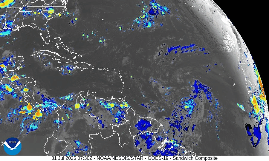
Gulf & Caribbean Update
No disturbances in the Gulf or Caribbean seas.
High-pressure dominance maintains generally dry conditions, with scattered showers typical of early August.
Expect stable marine conditions without organized tropical activity.
GOES-19 - Sector view: Gulf of America - Sandwich
GOES-19 - Sector view: Caribbean - Sandwich
Florida Forecast
Temperature & Humidity: Highs near 90°F under humid, muggy conditions.
Rain Chances: 40–50% for afternoon thunderstorms powered by sea breeze activity—not tropical in nature.
Winds: Light and variable inland, becoming southeast near the coast.
No tropical threats are expected to impact Florida today.
Rain forecast visualization courtesy of Windy.com
Prep Tip for the Day: Monitor Beach & Marine Conditions
Though Dexter is offshore, it is generating dangerous rip currents along the U.S. East Coast—from Florida through New England. Stay behavior-aware and heed coastal safety warnings even without landfall forecast.
Outlook
Dexter is weakening but remains watchable over open waters. The disturbance off Florida and the wave from Africa are the two main areas of tropical interest, each with moderate development odds this week. Persistent SAL and shear are still limiting, but conditions may shift toward favorability as August evolves.
TL;DR – August 6 Summary
Dexter weakening, staying over the open Atlantic.
Disturbance near Florida coast: 40% chance of development, may bring rain and marine effects.
Wave off Africa (~30°W): 50% development odds in 7 days.
Warm SSTs support activity, but SAL and wind shear remain inhibitory.
No immediate threats to Florida; hazardous rip currents possible.
Watch conditions as hurricane season builds toward mid‑August.
Stay prepared and stay informed — daily updates available at Cat5Prep.com.
Atlantic Hurricane Outlook – July 31, 2025: Tropics Active But No Storms on the Horizon
Tropical waves continue to move across the Atlantic, but none show signs of organization. Saharan dust and wind shear are keeping storm development in check—for now.
*Those who like data, continue reading. Those it prefer the quick version, jump to the TL;DR here.
The Atlantic basin continues to host several tropical waves—but none are expected to organize into tropical cyclones over the next seven days. Despite warm seas and increasing moisture, wind shear and Saharan dry air maintain a suppressive environment.
Atlantic Basin Summary
As of the 8:00 AM EDT Tropical Weather Outlook (TWO) from the National Hurricane Center, there are:
No active tropical cyclones.
No areas under investigation for development in the next 48 hours or seven days.
The Tropical Weather Discussion (issued at ~12:15 UTC) reveals:
A tropical wave near 43°W (south of 22°N) moving westward at 10–15 kt, with scattered moderate convection between 4–10°N.
Another wave near 55°W (south of 18°N) moving west at about 10 kt, with minimal convection.
These waves are being monitored but show no organized structure or circulation at present.
Key Weather Factors
Sea Surface Temperatures (SSTs):
Across the Gulf of Mexico, Caribbean, and MDR, SSTs range from 29–31 °C (84–88 °F)—values supportive of tropical development if atmospheric conditions improve.
Wind Shear:
Remains moderate to high across most of the Atlantic basin, limiting vertical development of disturbances.
Saharan Air Layer (SAL):
Dry and dusty air persists across the central and eastern Atlantic, suppressing convection in the MDR.
Atmospheric Moisture:
While moisture is gradually increasing near the Caribbean and western tropical Atlantic, the dry air and shear continue to hinder system organization.
Gulf of America (Mexico) & Caribbean Region
No low-pressure areas or disturbances are being tracked.
A dominating high-pressure ridge supports generally light winds and calm seas across the Gulf and Caribbean.
Offshore rainfall remains typical for this time of year—no tropical impacts on the Florida peninsula.
GOES-19 - Sector view: Gulf of America - Sandwich
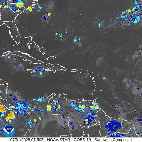
GOES-19 - Sector view: Caribbean - Sandwich
Florida Forecast
High temperatures: Near 90 °F under humid conditions.
Afternoon showers and thunderstorms: 40–50% likelihood due to sea breeze convergence.
Winds: Light and variable inland; east-southeasterly along the coast.
Precipitation: Not driven by tropical systems.
Rain forecast visualization courtesy of Windy.com
Preparation Tip: Review Your Evacuation Plan
Take advantage of the lull to finalize your hurricane readiness:
Verify evacuation zones and travel routes.
Confirm alert registration with local and state emergency systems.
Update contact information and checklist locations with household members.
Outlook & Future Signal
Although today’s conditions remain tranquil, the ongoing wave train emerging from Africa and gradually improving moisture and SST profiles suggest that rainfall and organization potential may increase in early August.
TL;DR – July 31, 2025 Snapshot
No tropical systems present.
Two tropical waves travel west, but show none of the structure needed for development.
Strong wind shear and Saharan dust continue to suppress storm formation.
Warm waters and increased moisture hint at higher activity potential in August.
Stay informed and prepare while the pace allows. Daily updates continue at Cat5Prep.com.
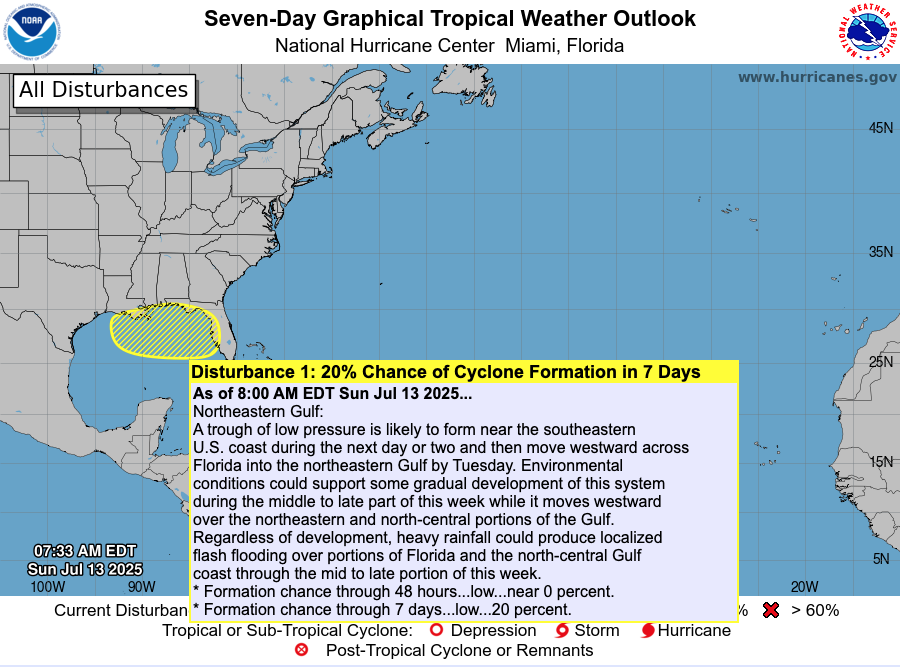
Atlantic Hurricane Outlook – July 13, 2025: Tropics Quiet, Gulf Trough Under Watch
No named storms today, but a low-pressure trough drifting toward the Gulf of Mexico could bring rain and potential tropical development later this week.
The Atlantic basin remains calm today, with no active named storms. However, meteorologists are tracking a low-pressure trough emerging off the Southeast U.S. coast, gradually drifting into the Gulf of Mexico. This system has a low (20%) chance of organizing into a subtropical or tropical system later this week .
Atlantic Overview: Quiet But Evolving
As per the 8 AM EDT NHC Tropical Weather Outlook:
No active tropical cyclones across the basin.
The Southeast U.S. trough is expected to push into the Gulf by Tuesday.
Formation chances: <1% in next 48 hours, ~20% over 7 days .
Though not tropical now, its movement may increase rainfall and raise attention if organization begins.
Satellite view via Windy.com
Sea Surface Temperatures: A Warm Platform
The Gulf of Mexico continues to show SSTs 2–4°F above average, providing a warm environment for storm development later this season.
Caribbean and Main Development Region (MDR) SSTs also remain elevated, keeping hurricane fuel accessible .
Sea Surface Temperature via Windy.com
Atmospheric Setup: Suppression in Play

Wind Shear Courtesy of https://tropic.ssec.wisc.edu/
Wind shear remains moderately strong across much of the basin, hindering storm development.
Saharan dust is still prevailing over the eastern Atlantic, suppressing early-season storm growth.
Moisture levels are slowly increasing in the Gulf and Southeast U.S., signaling gradual support for convection.
Saharan Air Layer (Dust) via Windy.com
Regional Weather: Rain on the Rise
Expect increased showers and thunderstorms along the Southeast U.S. and Gulf coasts as the trough approaches.
Florida will likely see scattered afternoon storms, typical for July, especially as the trough draws moisture inland.
Thunderstorm Forecast (ECMWF) via Windy.com
Prep Tip of the Day: Be Rainwise
Even without strong winds, heavy rainfall can pose serious hazards:
Track the trough’s movement—it could bring localized flash flooding to Gulf coast areas.
Ensure storm drains and sump pumps are clear and functional.
Keep sandbags and quick barriers ready if you're in low-lying zones.
Test your NOAA Weather Radio and mobile alerts to stay ahead of rainfall warnings.
Looking Ahead: Waters Stay Warm—Storms Could Spark
Although the tropics are peaceful now, the combination of warm ocean temperatures, easing atmospheric inhibitors, and growing seasonal moisture suggest readiness for evolution. The trough may serve as the first spark of Gulf activity, with a watchful eye needed through mid- to late-week.
Stay alert and check back tomorrow for your latest update from Cat5Prep.com.

Atlantic Hurricane Outlook – June 1, 2025: Opening Day, But All’s Quiet… For Now
June 1 marks the official start of the 2025 Atlantic hurricane season. No storms are currently active, but rising sea surface temperatures and favorable patterns suggest a potentially busy season ahead.
The Atlantic hurricane season officially begins today, June 1, and while the tropics are currently quiet, forecasters are already eyeing the environmental conditions that could lead to a very active season. For residents in hurricane-prone regions, now is the time to prepare—not relax.
Atlantic Basin: Calm Start to the Season
As of the latest update from the National Hurricane Center (NHC), there are no active tropical systems, no areas of concern, and no immediate threats expected over the next seven days.
This quiet opening is not unusual. Early June often sees little activity in the deep tropics. However, this calm is not expected to last. Sea surface temperatures are running well above average, and the atmospheric setup is trending toward conditions favorable for development later this month.
Satellite data courtesy of Windy.com
Sea Surface Temperatures: Running Hot
The Atlantic basin is notably warm for this early in the season, providing more than enough fuel for potential tropical cyclones.
Gulf of America (Mexico): 2 to 4°F above normal, with widespread areas exceeding 86°F (30°C)
Caribbean Sea: Similar temperature anomalies, especially in the western basin
Main Development Region: Continues trending above average
Historically, warmer-than-average waters correlate with more frequent and intense storms.
Sea surface temperature data courtesy of Windy.com
ENSO Neutral: La Nada Takes Over
The El Niño–Southern Oscillation (ENSO) is now in a neutral phase. With El Niño in the rearview and La Niña not yet in play, we enter what meteorologists call "La Nada"—a neutral state that often removes inhibiting influences on hurricane formation.
Decreased wind shear is expected across the Atlantic basin
A neutral ENSO often correlates with average to above-average storm development
Other patterns, like the Madden–Julian Oscillation (MJO), may become more influential later in the month
Saharan Air Layer: Dust Still in Play
The Saharan Air Layer (SAL) continues to stream across the Atlantic from Africa, bringing with it dry, dusty air that temporarily suppresses tropical development.
Inhibits cloud formation and convection
Increases atmospheric stability
Introduces vertical wind shear
The SAL typically begins to weaken later in June, removing one of the key atmospheric barriers to tropical development.
Saharan Dust SAL data courtesy of Windy.com
Eastern Pacific: Alvin Weakens
Tropical Storm Alvin, the Eastern Pacific's first named storm of the season, formed earlier this week and is now weakening.
Location: Approximately 710 miles south of Baja California
Movement: Northwest at 13 mph
Maximum Winds: 50 mph, weakening
Forecast: Expected to dissipate within 36 hours
Though Alvin poses no threat to land, its formation signals that tropical systems are beginning to stir in the broader region.
Alvin wind accumulation in Eastern Pacific data courtesy of Windy.com
Florida Forecast: Statewide Conditions Typical for June
Across the state of Florida, today's weather reflects classic early summer patterns.
North Florida: Highs in the upper 80s, lows in the mid-60s, low humidity, mostly clear skies
Central Florida: Highs near 90°F, afternoon humidity and a slight chance of thunderstorms
South Florida: Highs in the mid-80s, lows in the upper 70s, muggy with isolated afternoon storms
These are the kinds of conditions that typically precede the onset of more frequent tropical activity in late June and July.
Temperature across Florida data courtesy of Windy.com
Preparation Tips: Start Now, Not Later
With the season now officially underway, take time today to prepare while skies are still clear.
Review your family emergency plan and evacuation zone
Check and restock your hurricane kit
Confirm your insurance coverage and take property photos
Sign up for local emergency alerts and follow trusted forecast sources
Bookmark Cat5Prep.com and the National Hurricane Center
Looking Ahead
Although the season begins on a quiet note, forecasters warn that this calm is likely temporary. Record sea surface temperatures, a neutral ENSO, and easing wind shear all point to increased tropical activity as we move deeper into June.
Stay ready, stay informed, and check back daily for new updates from Cat5Prep.

*As an Amazon Associate, we earn from qualifying purchases.