
Atlantic Hurricane Outlook – August 2, 2025: Watching Waves, But No Storms Expected
The Atlantic remains calm to start August, with no storms expected this week. A few tropical waves are being monitored, but dry air and wind shear continue to suppress development—for now.
*Those who like data, continue reading. Those it prefer the quick version, jump to the TL;DR here.
As we settle into early August, the Atlantic remains quiet—no active tropical systems and no development forecasted over the next seven days. Although several tropical waves continue moving westward, persistent upper-level wind shear and Saharan dust limit their potential for organization.
Atlantic Basin Summary
Latest NHC Tropical Weather Scales:
The 8 AM EDT Tropical Weather Outlook confirms no systems expected to form within seven days.
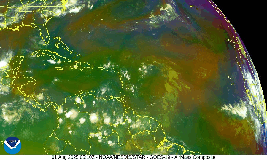
Multiple tropical waves are active:
A wave near 43–50°W with scattered convection.
A new wave moving off Africa near 30°W, gradually tracking westward.
None display organized circulation or development potential at this time.
Satellite imagery provided by Windy.com
Environmental Conditions
Sea Surface Temperatures (SSTs):
29–31 °C (84–88 °F) across the Gulf of Mexico and Caribbean.
MDR temperatures remain slightly above average, offering rising energy for late-season storms.
Wind Shear:
Still moderate to high across much of the basin, inhibiting vertical growth.
Saharan Air Layer (SAL):
Thick dry air layer continues across most of the MDR, suppressing convection and storm development.
Atmospheric Moisture:
Gradually increasing in the western Atlantic and Caribbean—monitoring for signs of improved convective support.
Gulf of America (Mexico) & Caribbean Region
No disturbances currently monitored.
A dominant high-pressure ridge maintains light winds and calm seas.
Scattered showers along Florida’s west coast remain typical summer moisture—not tropical in origin.
Radar imagery courtesy of Windy.com
Florida Forecast
Highs: Upper 80s to low 90s °F with high humidity.
Rain Chances: 40–50% for scattered afternoon thunderstorms due to seabreeze convergence.
Winds: Light and variable.
No tropical threats expected in Florida today.
Rain forecast visualization courtesy of Windy.com
Seasonal Outlook
The Atlantic season to date includes three named storms (Andrea, Barry, and Chantal), but lacks any hurricanes—a below-average ACE, echoing early-season inactivity last seen in 2009.
NOAA and CSU continue to forecast above-average hurricane activity overall, with 13–19 named storms and 6–10 hurricanes anticipated this season.
August typically marks the ramp-up of tropical activity, especially across the MDR and Gulf of Mexico, where conditions may become more favorable by mid-month.
Prep Tip of the Day: Verify Your Alert Setup
Now is a good time to:
Confirm you’re registered with local emergency alert systems.
Test NOAA weather radios and app notifications.
Re-check family communication plans and emergency kit locations.
Looking Ahead
While the forecast remains calm now, early August often brings the first major shifts in seasonal activity. Keep tracking tropical waves as they approach warmer waters and potentially lower shear environments.
TL;DR – August 2, 2025 Hurricane Summary
No active storms or developing systems in the Atlantic.
Several tropical waves are present but remain weak and disorganized.
High wind shear and Saharan dust continue to suppress development.
Sea surface temperatures are high and rising.
Historical patterns suggest increased activity may begin in mid‑August.
Stay prepared and stay informed with daily updates from Cat5Prep.com.
Atlantic Hurricane Outlook – July 31, 2025: Tropics Active But No Storms on the Horizon
Tropical waves continue to move across the Atlantic, but none show signs of organization. Saharan dust and wind shear are keeping storm development in check—for now.
*Those who like data, continue reading. Those it prefer the quick version, jump to the TL;DR here.
The Atlantic basin continues to host several tropical waves—but none are expected to organize into tropical cyclones over the next seven days. Despite warm seas and increasing moisture, wind shear and Saharan dry air maintain a suppressive environment.
Atlantic Basin Summary
As of the 8:00 AM EDT Tropical Weather Outlook (TWO) from the National Hurricane Center, there are:
No active tropical cyclones.
No areas under investigation for development in the next 48 hours or seven days.
The Tropical Weather Discussion (issued at ~12:15 UTC) reveals:
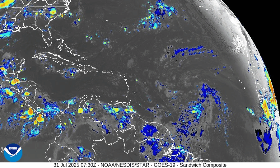
A tropical wave near 43°W (south of 22°N) moving westward at 10–15 kt, with scattered moderate convection between 4–10°N.
Another wave near 55°W (south of 18°N) moving west at about 10 kt, with minimal convection.
These waves are being monitored but show no organized structure or circulation at present.
Key Weather Factors
Sea Surface Temperatures (SSTs):
Across the Gulf of Mexico, Caribbean, and MDR, SSTs range from 29–31 °C (84–88 °F)—values supportive of tropical development if atmospheric conditions improve.
Wind Shear:
Remains moderate to high across most of the Atlantic basin, limiting vertical development of disturbances.
Saharan Air Layer (SAL):
Dry and dusty air persists across the central and eastern Atlantic, suppressing convection in the MDR.
Atmospheric Moisture:
While moisture is gradually increasing near the Caribbean and western tropical Atlantic, the dry air and shear continue to hinder system organization.
Gulf of America (Mexico) & Caribbean Region
No low-pressure areas or disturbances are being tracked.
A dominating high-pressure ridge supports generally light winds and calm seas across the Gulf and Caribbean.
Offshore rainfall remains typical for this time of year—no tropical impacts on the Florida peninsula.
GOES-19 - Sector view: Gulf of America - Sandwich
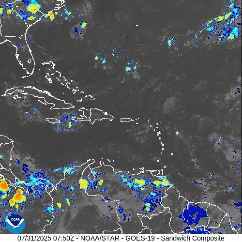
GOES-19 - Sector view: Caribbean - Sandwich
Florida Forecast
High temperatures: Near 90 °F under humid conditions.
Afternoon showers and thunderstorms: 40–50% likelihood due to sea breeze convergence.
Winds: Light and variable inland; east-southeasterly along the coast.
Precipitation: Not driven by tropical systems.
Rain forecast visualization courtesy of Windy.com
Preparation Tip: Review Your Evacuation Plan
Take advantage of the lull to finalize your hurricane readiness:
Verify evacuation zones and travel routes.
Confirm alert registration with local and state emergency systems.
Update contact information and checklist locations with household members.
Outlook & Future Signal
Although today’s conditions remain tranquil, the ongoing wave train emerging from Africa and gradually improving moisture and SST profiles suggest that rainfall and organization potential may increase in early August.
TL;DR – July 31, 2025 Snapshot
No tropical systems present.
Two tropical waves travel west, but show none of the structure needed for development.
Strong wind shear and Saharan dust continue to suppress storm formation.
Warm waters and increased moisture hint at higher activity potential in August.
Stay informed and prepare while the pace allows. Daily updates continue at Cat5Prep.com.

Atlantic Hurricane Outlook – July 23, 2025: Gulf Disturbance Brings Rain Risk, Tropics Mostly Stable
A low-pressure system in the north-central Gulf is bringing rain to Florida and the northern coast, but development remains unlikely. Multiple waves in the Atlantic are being monitored.
The Atlantic basin remains quiet overall, but a new area of interest has developed in the north-central Gulf of Mexico, with a low (10%) chance of tropical development. Elsewhere, multiple tropical waves continue their westward journey across the Atlantic, but none show signs of immediate organization.
Gulf of Mexico: Watching a Coastal Disturbance
As of the 8:00 AM EDT update from the National Hurricane Center, a trough of low pressure just offshore the southeastern United States is producing disorganized showers and thunderstorms over the north-central Gulf. The system is forecast to drift west-southwestward over the next day or two into more open waters.
Chance of development remains low (10%) as the system will likely move inland before organizing.
Regardless of development, locally heavy rain is expected along the Florida west coast and the northern Gulf coast through the weekend.
We'll continue to monitor this system closely for any signs of improvement in structure.
Satellite imagery courtesy of Windy.com
Atlantic Basin: Multiple Waves Being Tracked
There are no active tropical cyclones, but several waves are being tracked in the deep tropics:
A tropical wave near 40°W continues to produce scattered convection but remains disorganized.
A new wave near 23°W just off the African coast was introduced in this morning’s outlook. It’s producing moderate convection along its southern extent.
A low-pressure feature near 08N44W, embedded within the monsoon trough, is also aiding convection but not expected to develop in the near term.
These features will be watched for signs of improved structure as they move westward.

NOAA/NESDIS/STAR – GOES-19 Air Mass Composite – July 23, 2025
Caribbean & Western Atlantic: Typical July Conditions
Scattered thunderstorms continue near eastern Cuba, Hispaniola, and the southwest Caribbean.
Trade winds remain moderate to fresh across much of the basin.
Seas range from 4 to 8 feet, highest in the south-central Caribbean.
The Saharan Air Layer remains weak to moderate, allowing more moisture into the mid-tropics.
Florida Forecast
Highs: 89–92°F (32–33°C)
Humidity: High, with heat index values over 100°F possible
Rain chances: Elevated this afternoon due to outer moisture from the Gulf disturbance
Winds: Light east-southeast, higher near thunderstorms
Rainfall forecast (ECMWF) courtesy of Windy.com
Prep Tip of the Day: Don’t Let “Low Chances” Lull You
Even disturbances with low formation chances can bring:
Flash flooding
Power outages
Road hazards
Use today to test emergency alerts, stock up on essentials, and make sure you’re signed up with your county’s emergency management system.
Looking Ahead
While July continues to show gradual tropical stirring, the big-picture signals—warmer SSTs, decreasing shear, and more active wave patterns—still point toward a ramp-up in early August. Stay ahead of it, and keep checking back for the latest updates.
Atlantic Hurricane Outlook – July 13, 2025: Tropics Quiet, Gulf Trough Under Watch
No named storms today, but a low-pressure trough drifting toward the Gulf of Mexico could bring rain and potential tropical development later this week.
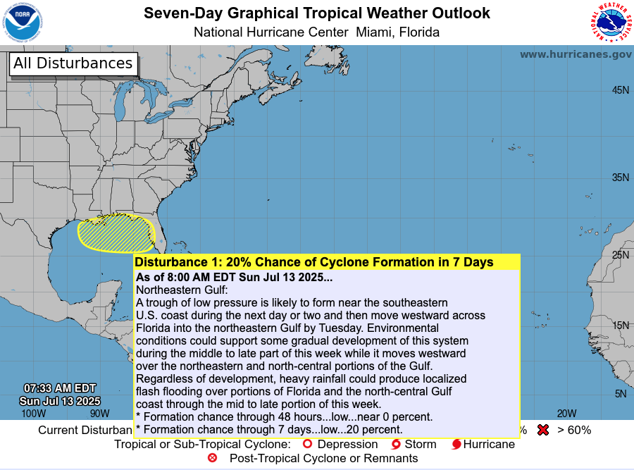
The Atlantic basin remains calm today, with no active named storms. However, meteorologists are tracking a low-pressure trough emerging off the Southeast U.S. coast, gradually drifting into the Gulf of Mexico. This system has a low (20%) chance of organizing into a subtropical or tropical system later this week .
Atlantic Overview: Quiet But Evolving
As per the 8 AM EDT NHC Tropical Weather Outlook:
No active tropical cyclones across the basin.
The Southeast U.S. trough is expected to push into the Gulf by Tuesday.
Formation chances: <1% in next 48 hours, ~20% over 7 days .
Though not tropical now, its movement may increase rainfall and raise attention if organization begins.
Satellite view via Windy.com
Sea Surface Temperatures: A Warm Platform
The Gulf of Mexico continues to show SSTs 2–4°F above average, providing a warm environment for storm development later this season.
Caribbean and Main Development Region (MDR) SSTs also remain elevated, keeping hurricane fuel accessible .
Sea Surface Temperature via Windy.com
Atmospheric Setup: Suppression in Play

Wind Shear Courtesy of https://tropic.ssec.wisc.edu/
Wind shear remains moderately strong across much of the basin, hindering storm development.
Saharan dust is still prevailing over the eastern Atlantic, suppressing early-season storm growth.
Moisture levels are slowly increasing in the Gulf and Southeast U.S., signaling gradual support for convection.
Saharan Air Layer (Dust) via Windy.com
Regional Weather: Rain on the Rise
Expect increased showers and thunderstorms along the Southeast U.S. and Gulf coasts as the trough approaches.
Florida will likely see scattered afternoon storms, typical for July, especially as the trough draws moisture inland.
Thunderstorm Forecast (ECMWF) via Windy.com
Prep Tip of the Day: Be Rainwise
Even without strong winds, heavy rainfall can pose serious hazards:
Track the trough’s movement—it could bring localized flash flooding to Gulf coast areas.
Ensure storm drains and sump pumps are clear and functional.
Keep sandbags and quick barriers ready if you're in low-lying zones.
Test your NOAA Weather Radio and mobile alerts to stay ahead of rainfall warnings.
Looking Ahead: Waters Stay Warm—Storms Could Spark
Although the tropics are peaceful now, the combination of warm ocean temperatures, easing atmospheric inhibitors, and growing seasonal moisture suggest readiness for evolution. The trough may serve as the first spark of Gulf activity, with a watchful eye needed through mid- to late-week.
Stay alert and check back tomorrow for your latest update from Cat5Prep.com.