
Atlantic Hurricane Outlook – August 20, 2025: A Couple Systems In The Atlantic
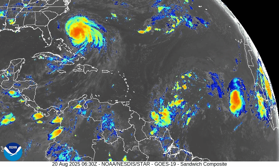
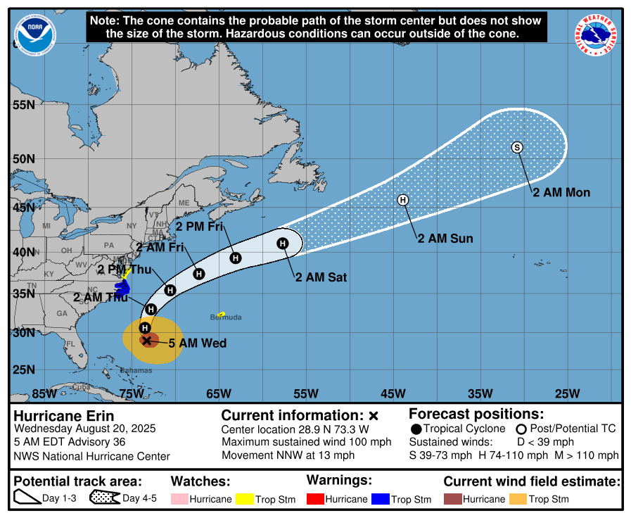
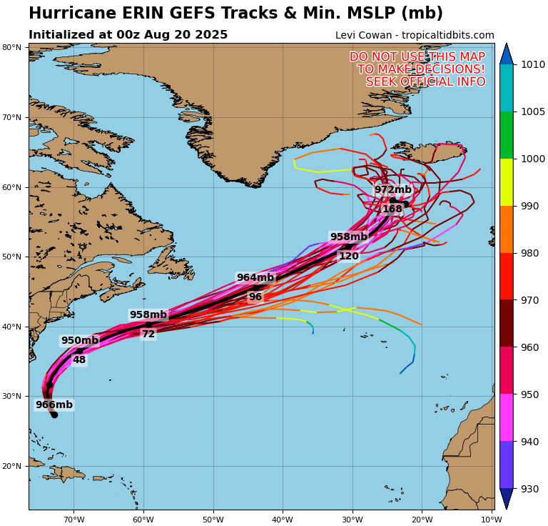
Hurricane Erin is holding as a Category 2 storm offshore, producing rip currents and coastal hazards along the East Coast. Meanwhile, the Gulf and Florida remain quiet, though tropical waves in the Atlantic are being monitored.
TLDR Version: Click Here
Current Tropical Systems

Hurricane Erin:
Erin has weakened slightly but remains a Category 2 hurricane as it tracks northeast, well offshore of the U.S. East Coast. The storm continues to generate dangerous swells, rip currents, and pockets of coastal flooding, especially from the Outer Banks northward into the Mid-Atlantic and New England. While direct landfall is not expected, coastal impacts remain significant.Disturbance in the Central Atlantic:
A tropical wave near 45°W continues to show signs of organization. Environmental conditions feature warm sea surface temperatures but are partially offset by moderate wind shear and Saharan Air Layer (SAL) dust intrusion. Development chances: 30% over 7 days.Far Eastern Atlantic Wave (off Africa):
A fresh wave near 25°W is emerging with scattered convection. It remains disorganized but will be monitored as it progresses westward. Development chances: low (20% over 7 days).


Gulf of America (Mexico) Outlook
The Gulf remains broadly quiet, with high pressure dominating and keeping conditions mostly stable. While moisture pockets are leading to afternoon thunderstorms, there are no signs of tropical development at this time. Sea surface temperatures are very warm (29–31°C), so the region will continue to be monitored closely heading into late August.
Florida Forecast
Florida remains under the influence of high humidity and afternoon sea-breeze thunderstorms, typical for August. Outer rainbands from Erin are not expected to impact the peninsula. No immediate tropical threats are forecast for the state in the near term.
Rain forecast visualization courtesy of Windy.com
Key Environmental Factors
Sea Surface Temperatures (SSTs): 29–31°C across the Gulf and Caribbean, MDR slightly above average — supportive for development.
Wind Shear: Moderate over the central Atlantic, helping limit wave organization.
Moisture: Gradual increase in the western Atlantic, but SAL dust continues to suppress deep convection in parts of the MDR.

Outlook Summary
Hurricane Erin remains a strong offshore system, generating significant surf and rip currents along the East Coast.
Central Atlantic disturbance carries moderate development potential but faces shear and dust challenges.
Gulf of Mexico and Florida remain calm with no immediate tropical concerns, though warm waters warrant close monitoring later this month.
TL;DR
Hurricane Erin is now a Category 2 offshore system, still driving dangerous surf and rip currents up the East Coast. The Gulf of Mexico and Florida stay quiet with only scattered thunderstorms, while the central Atlantic wave shows some development potential but is being held back by wind shear and Saharan dust.
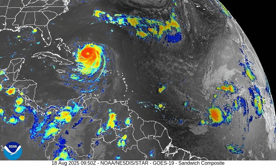
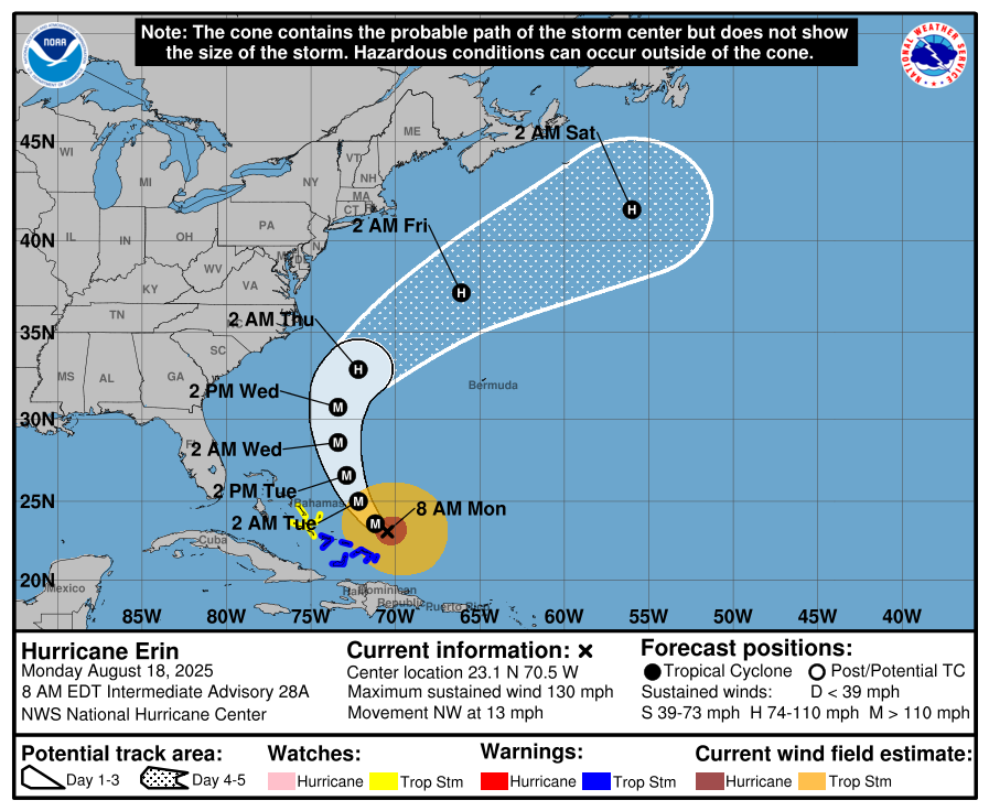
Atlantic Hurricane Outlook – August 18, 2025Hurricane Erin re-strengthens to Category 4
Hurricane Erin has regained Category 4 strength east of the Bahamas, bringing life-threatening surf and rip currents along the East Coast. While the U.S. mainland is safe from direct impacts, evacuations are underway in the Outer Banks. Gulf and Florida conditions remain quiet with only routine storms.

TLDR Version; Click Here
Hurricane Erin re-strengthens to Category 4; East Coast braces for powerful surf and rip currents
Hurricane Erin has re-intensified into a Category 4 storm, centered roughly 100 miles east of Turks and Caicos and the southeastern Bahamas. The U.S. mainland remains out of Erin’s direct path, but life-threatening surf, erosion, and coastal flooding are expected along the Eastern Seaboard. Meanwhile, a separate Atlantic disturbance now carries a 50% chance of tropical development later in the week. No tropical threats currently exist for the Gulf or Florida.
Atlantic Basin Overview
Hurricane Erin (Cat 4): Sustained winds are around 130 mph, with tropical-storm-force winds extending up to 230 miles from the center. A tropical storm warning is in effect for the Turks and Caicos and the southeastern Bahamas, while a tropical storm watch is in place for the central Bahamas.
Coastal Threats: The Outer Banks of North Carolina, including Hatteras Island, face mandatory evacuations due to expected high surf and coastal flooding—even without landfall. Wave heights may reach 20 ft, especially during high tides, while Bermuda could see even larger 25–30 ft waves. Rip current risk is moderate to high, spreading across East Coast beaches.
Other Atlantic Activity: A new disturbance in the eastern Atlantic now has a 50% chance of becoming tropical within 7 days. It’s forecast to approach the Lesser Antilles later this week, potentially enhancing rain and wind there.
We’re monitoring this new low-pressure system that is trailing Erin. Preliminary models are showing a similar path to Erin, but closer to the US Coastline. This could change drastically in the next several days.


Potential for organization in Red Circle - ECMWF Model
Potential for organization in Red Circle - GFS Model
Gulf of America (Mexico) & Caribbean
Gulf: No tropical development is anticipated. A lack of organized circulation and moderate shear conditions minimizes the likelihood of new cyclogenesis.
Caribbean Sea: Active only in the context of Erin—no other systems are currently being monitored.
Florida & Southeast U.S. Forecast
Florida: Expect typical mid-August weather—hot with daily afternoon showers and storms, especially inland. No tropical impacts are expected.
East Coast Beaches: Prepare for increasing surf, coastal erosion, and hazardous rip currents beginning midweek as swells from Erin arrive. Beaches without lifeguards pose significant dangers.
Rain forecast visualization courtesy of Windy.com
Environmental Conditions (Why Erin Strengthens)
Sea Surface Temperatures (SSTs): Still in the high 80s °F (near 30 °C) across the Atlantic, providing ample heat for Erin’s sustainment.
Wind Shear: Still moderate but trending downward near Erin’s path, facilitating its re-strengthening to Category 4.
Dry Air/Saharan Dust: Continues to affect waves farther east, suppressing development elsewhere; Erin’s size and organization now buffer these effects.
Preparedness Summary
Erin stays over open water but poses significant marine and coastal hazards—especially in the Outer Banks and along the East Coast.
Evacuations in place for vulnerable coastal locations such as Hatteras Island.
Florida and Gulf regions remain free from direct tropical threats—just routine summer storms.
Beachgoers: Avoid swimming where there are no lifeguards. Monitor local advisories for surf and rip current warnings.
TL;DR – August 18 Snapshot
Hurricane Erin strengthens back to Category 4 offshore; dangerous surf and rip currents expected along East Coast.
Eastern Atlantic wave may develop; 50% development odds in coming days.
Gulf and Florida remain quiet with no tropical threats.
Coastal communities, especially in NC, should act on evacuation orders and heed marine hazard alerts.

Atlantic Hurricane Outlook – July 27, 2025: Calm Conditions Continue Despite Active Waves
The tropics stay quiet on July 27, 2025, but tropical waves in the deep Atlantic are being closely monitored. No development is expected in the next 7 days, but changes could come as we approach August.

*Those who like data, continue reading. Those it prefer the quick version, jump to the TL;DR here.
The Atlantic basin remains free of named storms this morning, with no tropical cyclone formation expected over the next seven days. However, meteorologists are closely monitoring several tropical waves in the deep eastern Atlantic that could signal a developing pattern as we head into August.
Atlantic Basin: Quiet—but Watchful
No active tropical cyclones in the Atlantic basin.
The National Hurricane Center (NHC) reports that no tropical development is expected over the next 7 days.
Tropical waves in the eastern and central Atlantic continue to be monitored for organization.
Gulf of Mexico and Caribbean: No Significant Activity
No low-pressure disturbances currently under watch.
Conditions in the Gulf remain stable, with typical afternoon thunderstorms but no signs of tropical development.
Lower Caribbean waters remain under fresh easterly trade winds, with rather isolated convection near Central America.
Tropical Waves: Deep Atlantic Features to Monitor
According to the NHC’s Tropical Weather Discussion:
A tropical wave near 27°W (south of 17°N) is moving west at ~10 kt, with scattered moderate convection noted between 5°N and 9°N.
A stronger wave near 54°W (south of 22°N) is moving west at 15–20 kt, with scattered convection between 5°N–23°N.
An area of low pressure embedded in the monsoon trough near 8°N44°W is also aiding scattered convection but remains disorganized.
None of these systems currently have the structure required for classification, but they inhabit regions where sea surface temperatures and wind shear may soon become more conducive to development.
Environmental Conditions Snapshot
The Saharan Air Layer (SAL) remains strong across the eastern Atlantic, suppressing mid-level moisture and convection.
Wind shear in the central Atlantic remains moderate to high, limiting tropical organization—though forecasts suggest a gradual reduction heading into early August.
Sea surface temperatures across the Main Development Region (MDR) remain above average, providing energy should conditions improve later this month.
Dust & SAL data from Windy.com
Florida Forecast
Highs around 90 °F with coastal humidity making it feel hotter.
Rain Chance: 40–50% for scattered afternoon thunderstorms driven by sea breeze convergence.
Winds: Light and variable, shifting to southeasterly in the afternoon.
No tropical impacts expected today.
Rain forecast visualization courtesy of Windy.com
Prep Tip of the Day: Check Your Weather Apps and Alerts
While the tropics are quiet, confirming your local alert settings and weather tool readiness can make all the difference:
Enable push notifications for National Hurricane Center advisories.
Confirm alert registration with your county emergency system.
Test weather apps and bookmarks on all household phones and devices.
Looking Ahead: August May Bring Change
Though today’s conditions remain tranquil, the presence of several tropical waves moving into warmer Atlantic waters—combined with weakening Saharan dust and decreasing wind shear—suggest a gradual shift toward a more active setup. Historically, the first week of August often kicks off heightened tropical activity.
Stay alert. Stay ready. Daily Atlantic updates from Cat5Prep.com.
TL;DR
Atlantic Hurricane Forecast for July 27, 2025
No tropical storms are expected this week — the Atlantic remains quiet.
Three tropical waves are being monitored across the basin. None are showing strong signs of development yet.
Sea surface temperatures are hot and rising — especially in the Gulf and Caribbean — setting the stage for activity in August.
Wind shear and dry air (Saharan dust) continue to limit development for now.
Florida and the Gulf Coast: Typical summer weather—hot, humid, and scattered afternoon storms.
Prep Tip: Now is the time to stock up on essentials and finalize your hurricane communication plan.
No immediate threats, but stay alert. The quiet won’t last forever.

Atlantic Hurricane Outlook – June 10, 2025: Quiet Continues, But Observers Stay Alert
No storms in sight, but sea surface temperatures continue to rise and wind shear is gradually easing—signs that the quiet start to the 2025 hurricane season may not last.
The tenth day of the 2025 Atlantic hurricane season opens with calm skies and no immediate threats. The latest update from the National Hurricane Center (NHC) confirms no active systems and no expected tropical cyclone formation over the next seven days. Early June often starts this way, but with sea surface temperatures climbing and atmospheric factors slowly shifting, vigilance remains important.
Atlantic Basin: No Systems in Sight
No active tropical cyclones
No areas of interest
No development anticipated within 7 days
This outlook aligns with the expected early-season lull, but conditions are steadily changing.
Satellite data courtesy of Windy.com
Sea Surface Temperatures: Warming Trend Continues
Gulf of Mexico & Western Caribbean: Still in the low to mid‑80s °F (around 27–29 °C), ideal for fueling storms when other factors permit
Main Development Region (MDR): Running warmer than average for early June—enough to support development later this month
These warm waters are critical as the season progresses.
Sea Surface Temperature data courtesy of Windy.com
Atmospheric Conditions: Mixed Signals
Wind Shear: Moderate to high across much of the basin, particularly within the western Caribbean and central Atlantic—limiting today’s storm potential
Moisture: Mid-level moisture appears to be on the rise, which could support future thunderstorm activity

Wind Shear Courtesy of https://tropic.ssec.wisc.edu/
Saharan Air Layer: A Dry Deterrent
A robust plume of Saharan dust continues to suppress tropical wave development across the eastern Atlantic and MDR
This dry layer is expected to ease by late June, removing one of the key early-season inhibitors
Saharan Air Layer data courtesy of Windy.com
Thunderstorm Activity: Routine, Not Tropical
Florida & Southeastern U.S.: Expect isolated afternoon storms typical for June
Western Caribbean: A few disorganized showers and storms—no rotation or organization evident
Atlantic Ocean: Quiet, with no tropical wave activity currently observed
Thunderstorm data courtesy of Windy.com
Florida Forecast (Statewide)
Highs: Upper 80s to low 90s °F (31–33 °C)
Humidity: Moderate to high—classic muggy comfort
Rain: Scattered afternoon/evening showers typical of early summer
Winds: Light and variable
Rain data courtesy of Windy.com
Prep Tip of the Day: Check Evacuation Zones
With time on your side:
Confirm your evacuation zone and review the planned evacuation route
Update your family emergency contact lists
Ensure your NOAA weather radio and mobile alert settings are active
Keep local emergency management contacts accessible
Looking Ahead: Still Quiet, But Watch for Change
While no tropical development is expected this week, underlying conditions are subtly shifting:
Warm ocean waters persist
Atmospheric wind shear is forecast to gradually decrease
Moisture levels are on the rise
Saharan dust is weakening, removing suppression barriers
Early hurricane season often starts quietly—but conditions can change fast. Stay tuned to Cat5Prep.com for daily updates.