
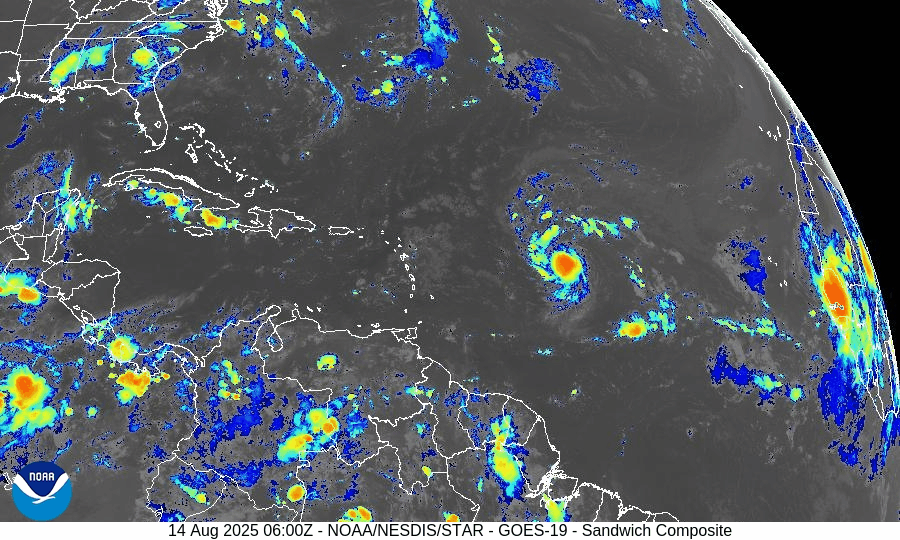
Atlantic Hurricane Outlook – August 14, 2025: Erin strengthening over the central Atlantic
Tropical Storm Erin is organizing over the central Atlantic and could become a hurricane within 24 hours. A low-risk Gulf disturbance may bring rain to parts of NE Mexico and South Texas. U.S. impacts are limited to surf and rip currents.
TLDR Version; Click Here
Erin strengthening over the central Atlantic; low‑chance Gulf disturbance; U.S. impacts limited to surf and rip currents for now

Tropical Storm Erin continues to organize over the central tropical Atlantic and is forecast to become a hurricane within the next day and possibly a major hurricane this weekend. A separate weak disturbance near the southwest Gulf has low odds of development. No tropical cyclones are expected to affect the U.S. in the short term, but increasing surf and rip current hazards are likely along portions of the East Coast into next week.
Atlantic Basin Overview
Tropical Storm Erin (central Atlantic):
Erin remains the only active named system. Hurricane Hunters are slated to sample the storm as it moves into a more favorable environment for intensification. Forecast guidance indicates hurricane strength by Friday and a risk of rapid intensification this weekend, with a track bending northwest and staying well east of the U.S. mainland.Current intensity snapshot:
Recent analyses place Erin over the central Atlantic with sustained winds near 50 mph as it organizes. Expect a steady strengthening trend over very warm waters.Swell & surf impacts:
Even with a track offshore, long‑period swells from Erin are expected to raise the risk of dangerous surf and rip currents along parts of the U.S. East Coast next week (Outer Banks and elsewhere). Coastal visitors should heed local beach forecasts.
Click Image For More Detail


Gulf of America (Mexico) & Caribbean
Southwest Gulf disturbance:
A weak, broad trough near the Bay of Campeche/Yucatán region will move west toward northeastern Mexico late week. NHC assigns low (20%) odds of development over the next 2–7 days; regardless, increased showers and a slight uptick in swells are possible near the lower Texas coast and northeast Mexico late Friday into Saturday.Rest of the Gulf & Caribbean:
Elsewhere, no organized disturbances. Typical trade‑wind showers continue in the Caribbean with seasonably warm seas and generally modest marine conditions.
GOES - GULF - August 14, 2025
GOES - Caribbean - August 14, 2025
Florida & Southeast U.S. Outlook
Florida (statewide):
A typical mid‑August pattern prevails—hot and humid with scattered afternoon thunderstorms driven by sea‑breeze collisions; storms are not tropical in origin. Coastal surf may gradually build this weekend into early next week from distant Erin, especially along the Atlantic beaches; check local rip‑current statements.Southeast coast:
Periods of higher surf and a rising rip‑current threat are expected as Erin strengthens and passes well offshore. Timing and magnitude depend on Erin’s exact intensity and position early next week.
Rain forecast visualization courtesy of Windy.com
Environmental Setup (Why/Why Not Development)
Sea Surface Temperatures:
MDR and western Atlantic waters remain well above average, offering ample oceanic heat content for Erin’s intensification.Wind Shear & Moisture:
Shear over Erin’s corridor is forecast to be moderate and easing, with improving mid‑level moisture—conditions supportive of strengthening. Farther west, shear and intermittent dry intrusions continue to limit other waves.Saharan Air Layer (SAL):
SAL is less dominant along Erin’s immediate path than earlier this month, while remaining a suppressing factor for some eastern/central MDR waves.
Preparedness Note

Use this window before any U.S. threats to review evacuation routes, check insurance documents, and ensure you’re enrolled in local emergency alerts. Elevated surf and rip currents can be dangerous well ahead of any storm—swim near lifeguards and follow beach flags.
TL;DR – August 14 Snapshot
Erin is strengthening over the central Atlantic; hurricane likely by Friday, major hurricane possible this weekend; track keeps it well offshore of the U.S. for now.
Low‑chance (20%) disturbance in the southwest Gulf may bring showers/surf to NE Mexico/South Texas late week; development unlikely.
Florida & Gulf: No tropical threats today—typical sea‑breeze storms; watch for building Atlantic surf/rip currents into next week.

Atlantic Hurricane Outlook – June 5, 2025: A Weak Low, a Wet Southeast, and a Watchful Eye
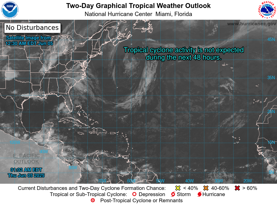
June 5 brings continued calm in the Atlantic, with no named storms and no areas of concern. But warm sea surface temperatures and slowly shifting atmospheric conditions suggest more activity may be on the way later this month.
The fifth day of the 2025 Atlantic hurricane season begins with calm skies and no tropical activity on the horizon. While this early June quiet is typical, forecasters are closely watching for subtle atmospheric shifts that may usher in increased activity later in the month. Now is the perfect time to double-check your emergency plans while the weather remains cooperative.
Atlantic Basin: No Immediate Concerns
As of the latest National Hurricane Center (NHC) update (8 PM EDT June 4 or the upcoming 2 AM EDT June 5 outlook):
No active tropical cyclones
No areas of interest under investigation
No development expected within the next 7 days
This quiet pattern aligns with the early season lull seen in most years before conditions ramp up later in June and July.
Satellite imagery courtesy of Windy.com
Sea Surface Temperatures: Warming Trend Continues
Ocean heat—an essential ingredient for tropical storm formation—is building across the Atlantic:
Gulf of America (Mexico): Widespread low to mid-80s°F (28–30°C), running above average
Western Caribbean: Seasonally warm, primed for potential development in coming weeks
Main Development Region (MDR): Temperatures are climbing faster than usual for early June, laying a foundation for future storms
Sea surface temperature data courtesy of Windy.com
Wind Shear & Moisture: Still Mixed, Slowly Improving
Atmospheric conditions aren’t yet fully supportive of tropical formation, but change is underway:
Wind Shear: Still moderate to high in the western Caribbean and central Atlantic—strong enough to disrupt organization. Long-range models show a gradual easing expected later in June
Moisture: Mid- and lower-atmosphere humidity is rising in the Gulf and Caribbean, hinting at increasing thunderstorm potential
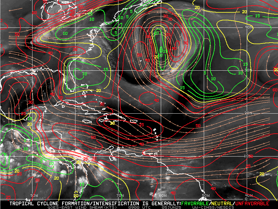
Wind Shear Courtesy of https://tropic.ssec.wisc.edu/
Saharan Air Layer: Strong, But Temporary Barrier
The Saharan Air Layer (SAL) remains a major suppressing force across the tropical Atlantic:
Dry, dusty air and associated wind shear prevent tropical waves from organizing
This layer is expected to weaken by mid-to-late June, removing a key obstacle to development
Saharan Air Layer data courtesy of Windy.com
Thunderstorm Activity: Typical Early Summer Patterns
No tropical cyclones—but thunderstorm activity continues in familiar places:
Florida: Scattered afternoon storms expected from daytime heating
Western Caribbean: Some disorganized convection is present but lacks structure
Off the U.S. East Coast: No significant organized convection at this time
Thunderstorm data courtesy of Windy.com
Florida Forecast – Early Summer Vibes Across the Peninsula
Expect a classic early summer day throughout Florida:
Highs: Upper 80s to low 90s°F (31–33°C) statewide
Humidity: Elevated levels bringing a muggy, tropical feel all day
Rain: Scattered afternoon thunderstorms likely, mostly brief and localized
Winds: Light and variable, with gentle breezes in many areas
Stay hydrated and be prepared for brief showers if you’re out and about this afternoon!
Radar data courtesy of Windy.com
Prep Tip of the Day: Verify Emergency Contact Information
Use this calm stretch to get communication-ready:
Update your family contact plan—make sure everyone knows who to call
Register for local emergency alerts via text or email
Bookmark vital sites like hurricanes.gov and Cat5Prep.com
Looking Ahead: Calm Now, But Stay Ready
No development is expected in the coming week—but the groundwork is being laid:
Warm waters across the basin
Easing wind shear on the horizon
Moisture and instability beginning to rise
The tropics may be quiet today, but the story of the 2025 hurricane season is just beginning. Stay informed, stay ready—and check back tomorrow for the next Cat5Prep.com update.

Atlantic Hurricane Outlook – June 2, 2025: A Quiet Morning, But Don’t Get Comfortable
June 2, 2025 Atlantic hurricane update: Calm skies for now, but unusually warm sea surface temperatures and shifting atmospheric conditions could spark activity later this month. Stay prepared with the latest forecasts and safety tips.
The second day of the 2025 Atlantic hurricane season begins under calm skies, but seasoned forecasters know better than to be lulled by the stillness. With sea temperatures running hot and atmospheric patterns shifting toward favorability, this quiet start may not last long.
Atlantic Basin: All Clear—For Now
As of this morning’s update from the National Hurricane Center (NHC), there are no active tropical cyclones, no areas of interest, and no tropical development expected over the next seven days.
This early-season lull is common in the first half of June, but warm waters and waning atmospheric inhibitors are quietly setting the stage for activity later this month.
Satellite data courtesy of Windy.com
Ocean Heat: The Hidden Fuel Source
Sea surface temperatures (SSTs) across the Atlantic basin are unusually high for this time of year—creating the potential for rapid storm intensification when development does occur:
Gulf of America (Mexico): Running 2–4°F above average, with large swaths above 86°F (30°C)
Caribbean Sea: Above-average temperatures, especially in the western basin
Main Development Region (MDR): Continuing to trend hot
Warm water is the engine that powers tropical cyclones, and the basin is already running well above operating temperature.
Sea surface temperature (SST) data courtesy of Windy.com
ENSO Status: La Nada Means No Safety Net
The El Niño–Southern Oscillation (ENSO) remains in a neutral phase, a state meteorologists often refer to as "La Nada."
El Niño has ended, removing the high wind shear that often suppresses Atlantic hurricanes
La Niña has not yet begun, but conditions may be trending in that direction later this summer
Neutral ENSO removes large-scale inhibitors, allowing the Atlantic to operate unchecked
Historically, neutral ENSO years correlate with average to above-average tropical storm activity.
Wind data courtesy of Windy.com
Saharan Air Layer: Dust Still Offers a Buffer—for Now
The Saharan Air Layer (SAL) continues to stretch across the tropical Atlantic, providing a temporary shield against storm formation:
Introduces dry, stable air into the atmosphere
Inhibits convection and cloud development
Increases wind shear in the central Atlantic
The SAL typically weakens by late June, making it easier for tropical waves to grow and organize.
Saharan Air Layer (SAL) dust data courtesy of Windy.com
Florida Forecast: A Summer Day with a Side of Humidity
Today’s conditions across Florida reflect typical early-June weather:
North Florida: Highs in the upper 80s, low humidity, and mostly sunny skies
Central Florida: Highs around 90°F, building humidity, and isolated afternoon storms
South Florida: Warm and muggy with highs in the mid-80s and a greater chance of scattered storms after 2 PM
It’s a classic Florida day—but the kind that often precedes the real tropical drama in July and August.
Weather radar forecast data courtesy of Windy.com
Prep Tips: Take Advantage of the Calm
With no storms on the map, today is a perfect day to prepare:
Review your hurricane plan and evacuation routes
Restock your hurricane kit
Double-check home insurance coverage
Take photos of property and valuables
Sign up for local emergency alerts
Bookmark trusted sources like Cat5Prep.com and the National Hurricane Center
Looking Ahead: Eyes on the Tropics
We remain in a short-term window of calm, but all indicators suggest that activity will ramp up in the coming weeks. Record-breaking sea surface temperatures and favorable upper-atmospheric trends point to early-season development potential later in June.
Stay alert. Stay ready. And check back tomorrow for your next update from Cat5Prep.

*As an Amazon Associate, we earn from qualifying purchases.