
Atlantic Hurricane Outlook – August 10, 2025: Multiple tropical waves crossing the Atlantic; development chances gaining
Multiple tropical waves are moving across the Atlantic today, but Saharan dust, wind shear, and dry air are keeping development chances low. Warm ocean temperatures could allow for changes later this week.
Atlantic Basin Overview
TLDR Version; Jump Here
As of this morning, no named tropical cyclones are active in the Atlantic. Several tropical waves are traveling westward across the Main Development Region (MDR), but most are struggling with environmental challenges that limit development. Sea surface temperatures are amply warm, so these waves will continue to be monitored as they move toward more favorable conditions later this week.
Key Systems We’re Watching
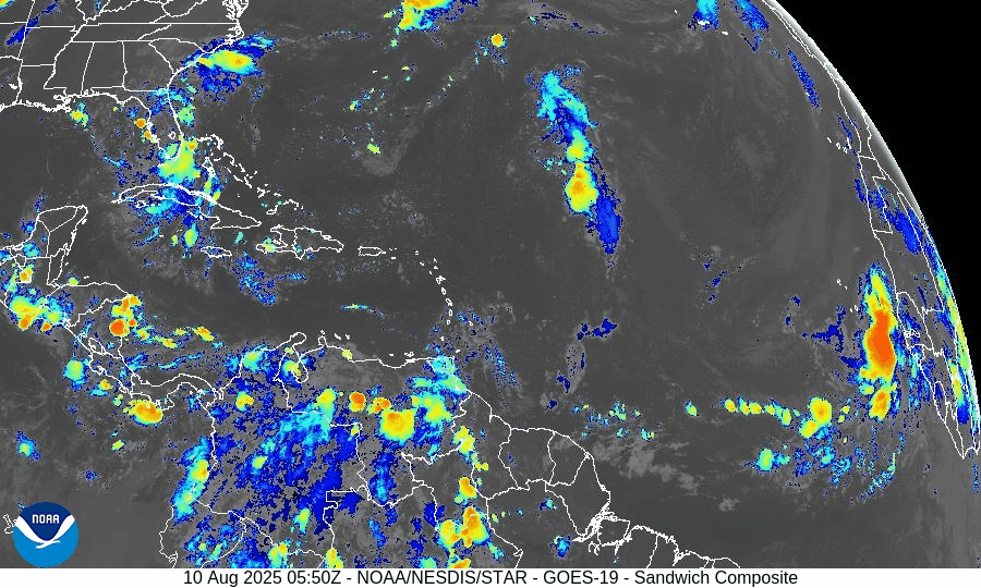
Central Atlantic Tropical Wave (~40°W):
Moving west at 10–15 knots with scattered convection. Organization remains limited due to dry air and moderate wind shear. Low chance of development over the next 7 days.Eastern Atlantic Tropical Wave (~23°W, off Africa):
Recently emerged from the continent with convection along its southern flank. Battling Saharan dust and dry air, keeping development chances low in the near term, potentially gaining strength in next 7-days.Monsoon Trough Low (~08N44W):
Embedded within the monsoon trough, sparking intermittent thunderstorm activity. No immediate signs of organized development.
GOES-19 - Sector view: Tropical Atlantic
GFS Future 8/18/25 - Curving NE off Coast of US
Euro Future 8/20/25 - Curving NE off Coast of US
Environmental Conditions
Sea Surface Temperatures (SSTs):
MDR running 28–29.5°C (82–85°F), with 29–31°C (84–88°F) in the Caribbean and Gulf of Mexico—plenty of fuel for storms if other conditions improve.Wind Shear:
Moderate to high shear in the central Atlantic is tilting storm structures and preventing vertical stacking of thunderstorms, slowing development.Moisture:
Humidity is increasing in the western tropical Atlantic, but dry air still lingers across much of the MDR.Saharan Air Layer (SAL):
Dry, dusty air extends across the eastern and central MDR, suppressing convection and capping short-term development potential.
Regional Outlooks
Gulf of Mexico:
No organized tropical disturbances. Typical summer thunderstorms will continue along coastal areas.Caribbean Sea:
Fresh trades persist in the south-central basin with occasional showers. No organized systems.U.S. Southeast & Florida:
Hot and humid with scattered sea-breeze thunderstorms each afternoon. No tropical threats expected today.
GOES-19 - Sector view: Gulf
GOES-19 - Sector view: Caribbean
Looking Ahead (5–10 Days)
The “wave train” from Africa will continue. As SAL weakens and shear pockets relax later this week, one of these waves could encounter a more favorable environment, especially in the central/western MDR.
Prep Reminder
This quiet stretch is the ideal time to review your hurricane plan, restock supplies, and confirm your household communication strategy.
TL;DR – August 10, 2025:
No active storms; several tropical waves in the MDR.
Development chances remain low in the short term due to SAL, wind shear, and patchy moisture.
Warm SSTs mean conditions could turn more favorable later this week. (Chance 70% Dev in next 7-days)
No tropical impacts expected for the U.S. today.

Atlantic Hurricane Outlook – July 25, 2025: Gulf Disturbance Monitored, Basin Remains Broadly Quiet
Stay updated on the Atlantic hurricane season: July 25, 2025. A weak Gulf disturbance brings rain to Texas & Louisiana, while the broader Atlantic remains quiet with no immediate threats. Prepare now for August!

As we close out the final week of July, the Atlantic basin remains broadly quiet. The only area of interest remains a weak disturbance in the western Gulf of Mexico, which continues to produce showers but shows little sign of organizing. Elsewhere, several tropical waves are making their westward march across the Atlantic, but no significant development is expected in the short term.
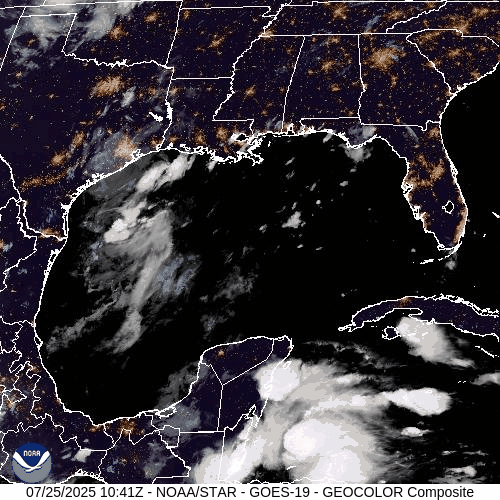
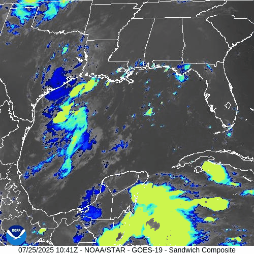
Gulf of Mexico: Weak Trough Brings Rain, Low Development Risk
A surface trough remains draped across the western Gulf of Mexico, generating scattered showers and isolated thunderstorms—particularly offshore of Texas and Louisiana.
The disturbance remains disorganized, with no closed low-level circulation.
Wind shear and surrounding dry air continue to limit development potential.
The National Hurricane Center (NHC) gives this system a low (10%) chance of development over the next 7 days.
However, heavy downpours and localized flooding remain possible across parts of coastal Texas and southwestern Louisiana today.
This weak trough is expected to gradually dissipate as it moves slowly westward.
Atlantic Basin: Multiple Waves, No Immediate Threats
The broader Atlantic remains seasonally active with several tropical waves but no current threats:
Tropical wave near 50°W: Moving westward with scattered convection; not showing signs of organization.
New wave near 23°W, just off the coast of Africa: Tracking westward along the monsoon trough with convection near its southern flank.
A weak low embedded in the monsoon trough near 08N44W is helping spark convection but lacks any closed circulation.
None of these features show signs of imminent development, though they will be monitored closely in the coming days.

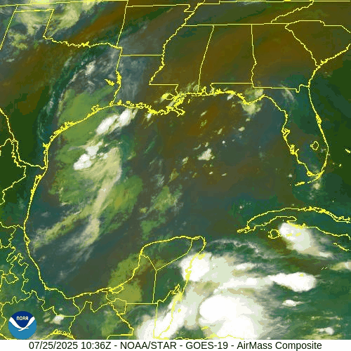
NOAA/NESDIS/STAR – GOES-19 Air Mass Composite – July 25, 2025
Sea Surface Temperatures & Atmospheric Conditions
Sea Surface Temperatures (SSTs) across the Gulf of Mexico and Main Development Region (MDR) remain well above average, supplying ample fuel for tropical development later this season.
Wind Shear remains moderate in the central and western Atlantic, limiting near-term organization.
The Saharan Air Layer (SAL) continues to suppress convection across much of the eastern Atlantic, especially north of the MDR.
Dust & SAL data from Windy.com
Florida Forecast: Typical Summer Pattern
Today’s outlook for Central Florida includes:
Highs in the low 90s°F (32–34°C)
Humidity: High, with heat indices nearing the upper 90s
Rain Chances: Scattered afternoon thunderstorms, driven by sea breeze and daytime heating
Winds: Light and variable, shifting southeast in the afternoon
No tropical impacts are expected for Florida at this time.
Radar imagery courtesy of Windy.com
Prep Tip of the Day: Review Your Evacuation Routes
Use this quiet period to refresh your storm plan:
Know your local evacuation zones
Map out primary and alternate routes
Keep a printed copy in your emergency kit in case power or cell service goes down
Share your plan with family or household members
Looking Ahead: Tropics Likely to Awaken in August
While the Atlantic basin remains quiet for now, the underlying signals—record SSTs, westward-moving waves, and easing shear—suggest a more favorable environment could emerge as we enter August. Stay alert, stay prepared, and keep checking in for daily updates.
Atlantic Hurricane Outlook – July 18, 2025: Tropics Quiet, But Gulf Moisture Persists
The Atlantic remains free of tropical storms today, but rising ocean heat and evolving atmospheric patterns point to potential development in the coming weeks. Stay prepared with Cat5Prep's daily hurricane outlook.
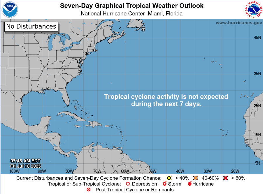
The Atlantic basin remains relatively quiet as we enter the weekend, with no active tropical cyclones or immediate threats on the map. However, lingering moisture from a weak low in the Gulf of Mexico continues to impact parts of the Southeast with enhanced rain chances. Meanwhile, environmental signals are gradually shifting toward favorability as we move closer to the climatological ramp-up in late July.
Atlantic Basin: Still Quiet, But Watchful
As of this morning’s update from the National Hurricane Center (NHC):
No active tropical cyclones
No named systems or advisories
No tropical development expected over the next 7 days
The basin remains in a holding pattern—but that may change in the weeks ahead.
Satellite imagery courtesy of Windy.com
Sea Surface Temperatures: Running Hot
Ocean heat content continues to build across key development zones:
Gulf of Mexico: Sea surface temperatures (SSTs) remain in the mid-to-upper 80s°F (29–31°C), well above average.
Western Caribbean: Waters continue to warm, supporting deep convection.
Main Development Region (MDR): SSTs between Africa and the Caribbean are approaching thresholds that historically support long-track hurricanes.
These conditions set the stage for rapid intensification when tropical systems do form.
Sea Surface Temperature data courtesy of Windy.com

Wind Shear and Atmospheric Moisture: Becoming More Conducive
While upper-level wind shear remains moderate in parts of the Caribbean and central Atlantic, it is gradually weakening—especially closer to the Gulf. Atmospheric moisture continues to increase:
Mid-level moisture is supporting thunderstorm development
Reduced shear and rising instability create a more supportive environment for potential tropical waves
This combination is worth monitoring as we approach the latter half of July.
Relative Humidity (ECMWF) data courtesy of Windy.com

Wind Shear Courtesy of https://tropic.ssec.wisc.edu/
Saharan Air Layer: A Temporary Shield
Dry air and dust from the Saharan Air Layer (SAL) remain active over the eastern Atlantic:
SAL suppresses convection by drying out the lower atmosphere
It also enhances wind shear, limiting vertical storm growth
This protective layer typically weakens in August
While it currently limits tropical wave development off Africa, its influence is expected to wane soon.
Saharan Air Layer (Dust) data courtesy of Windy.com
Gulf Moisture: Lingering Showers, Low Development Risk
A broad area of low pressure and enhanced moisture remains over the northern Gulf of Mexico:
Development chances remain very low
The system is disorganized, with no surface circulation
Still, heavy rain and localized flooding are possible today along the Gulf Coast, particularly in southern Alabama, the Florida Panhandle, and southeastern Louisiana
This disturbance is more of a rainmaker than a tropical threat but illustrates how even weak lows can impact coastal regions.
Rainfall forecast (ECMWF) courtesy of Windy.com
Florida Forecast: Humid and Storm-Prone
Expect classic July conditions across the state:
North Florida: Highs in the low 90s, partly cloudy, isolated afternoon storms
Central Florida: Around 91°F, muggy, with widespread PM storms
South Florida: Mid-to-upper 80s, very humid, storms possible after 2 PM
Local flooding is possible in poor drainage areas due to repeated rounds of heavy showers.
Thunderstorm forecast (ECMWF) courtesy of Windy.com
Prep Tip of the Day: Review Evacuation Zones
Now is the time to double-check your local evacuation zone and routes:
Know whether you're in a surge or flood-prone area
Identify multiple exit routes in case primary roads are closed
Plan ahead for pets, medication, and transportation
Being familiar with your zone before a storm is one of the best preparedness steps you can take.
Looking Ahead: A Quiet Stretch, But a Shift Is Coming
While the tropics are calm for now, the combination of warming waters, weakening wind shear, and deepening atmospheric moisture signals that a transition to a more active pattern is coming.
Expect activity to increase in late July into early August, as the historical ramp-up in hurricane season begins.
Check back tomorrow for the next update from Cat5Prep.com.
Atlantic Hurricane Outlook – July 9, 2025: Calm Seas Persist Amid Seasonal Build
The Atlantic remains quiet today, with no active storms and no development expected. But record-warm waters and shifting atmospheric patterns suggest that tropical activity could ramp up soon.
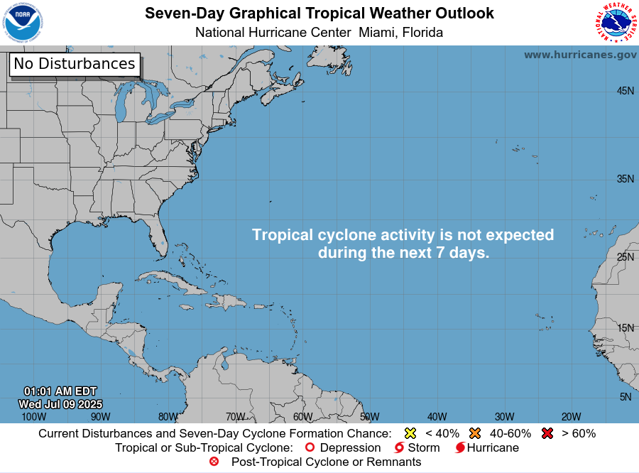
Mid-July typically signals more tropical activity—but today, the Atlantic remains unusually quiet. According to the latest NHC updates, no tropical cyclones are present, with no expected development over the next seven days. Despite the current calm, strong indicators suggest the season’s intensity is primed to rise.
Atlantic Basin: All Clear for Now
No active systems in the Atlantic, Caribbean, or Gulf
NHC forecast maintains zero development chances across the basin
This lull is rare for July and may end soon as heat and moisture build
Satellite view via Windy.com
Seasonal Outlook: Above-Normal Conditions Ahead
CSU’s July update continues to forecast an above-average season:
~17 named storms, including ~9 hurricanes and ~4 major hurricanes .NOAA similarly predicts 13–19 named storms, with a 60% chance of a busier-than-average season.
Sea Surface Temperatures: High Heat Levels
Atlantic SSTs remain well above normal—2–4°F above average—in the Gulf, Caribbean, and MDR
These elevated temperatures continue to provide plenty of energy for storm formation in the weeks ahead
Sea Surface Temperature via Windy.com
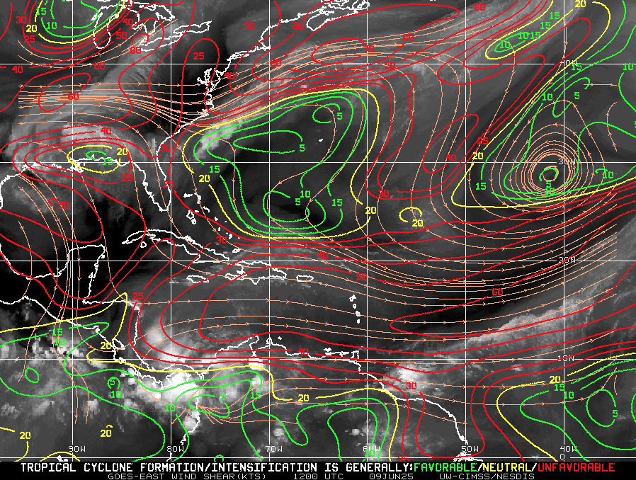
Atmospheric Conditions: Secondary Barriers Easing

Wind Shear Courtesy of https://tropic.ssec.wisc.edu/
Wind shear remains moderate-to-high, particularly in the eastern Atlantic—temporarily limiting development
Saharan Air Layer (SAL) and occasional dry mid-level air still suppress convection but are expected to diminish
Moisture is steadily increasing, with abundant humidity projected across storm-prone regions
Saharan Air Layer (Dust) via Windy.com
What to Watch Next
Upcoming Infrared and visible satellite loops for signs of organization
Shifts in wind shear over the Gulf and Caribbean
Any African easterly waves gaining moisture and structure
Wind Gust Accumulation Forecast (ECMWF) via Windy.com
Early July Trends
Only one named storm (Chantal) has formed so far, but it remained weak and quickly dissipated
History shows many July systems originate in the Gulf, Caribbean, or off the Southeast U.S. coast
Outlook: Active Patterns Brewing
While quiet now, the combination of warm SSTs, moist air, and weakening shear/SAL signals a rising likelihood of Atlantic development
Hurricane Season Peak is still ahead—August through October—but increased vigilance is essential now
Prep Tip of the Day: Check Your Alert Systems
With the season expected to intensify:
Confirm NOAA Weather Radio is operational
Enable emergency alerts on all devices
Update your hurricane kit and evacuation plan
Bookmark Cat5Prep.com and the National Hurricane Center for future updates
The Atlantic remains calm—but the foundation for tropical activity is strengthening daily. Stay alert, stay prepared, and check back tomorrow for your next Cat5Prep.com outlook.

Atlantic Hurricane Outlook – June 13, 2025: Record-Warm Waters, Calm Tropics
The Atlantic remains calm on June 13, 2025, with no tropical systems expected this week. But record-warm ocean temperatures hint at growing potential for storms later in June.
As of this morning, the Atlantic basin remains quiet with no active tropical cyclones, and the National Hurricane Center (NHC) is not monitoring any areas for development over the next seven days. This early season calm is typical for June, but it's occurring alongside some of the warmest sea surface temperatures (SSTs) on record for this time of year.

Atlantic Basin: No Immediate Threats
There are no named storms, no tropical disturbances, and no development expected through June 20, according to the NHC’s latest outlook. While quiet conditions aren’t unusual for early June, the current oceanic heat buildup is setting the stage for a potentially more active second half of the month.
Satellite data via Windy.com
Sea Surface Temperatures: Running Hot
Across much of the Atlantic basin:
Gulf of America (Mexico): SSTs are in the low to mid-80s°F (28–30°C), well above average
Western Caribbean: Also warm, supporting favorable conditions for future development
Main Development Region (MDR): Temperatures continue to trend higher than normal — a red flag as we move closer to peak hurricane season
SST data via Windy.com
Atmospheric Conditions: Mixed Signals
Wind Shear: Remains moderate to high in some areas, limiting storm organization for now, but models show signs of gradual easing
Saharan Air Layer (SAL): Dry, dusty air continues to spread across the eastern and central Atlantic, suppressing convection
Moisture Levels: Slowly increasing in the western Caribbean and Gulf, signaling that the environment is gradually becoming more storm-friendly

Wind Shear Courtesy of https://tropic.ssec.wisc.edu/
Thunderstorm Activity: Diurnal, Not Tropical
Florida and the Southeast U.S.: Expect typical scattered afternoon thunderstorms, driven by heating — not tropical systems
Caribbean and Atlantic: No signs of organized storm activity
Thunderstorm data via Windy.com
Florida Forecast: Midsummer Preview
Highs: Upper 80s to low 90s°F (31–33°C)
Humidity: High — muggy conditions will persist
Rain: Afternoon storms likely in areas, but short-lived and localized
Winds: Light and variable
Thunderstorm data via Windy.com
Prep Tip of the Day: Know What to Watch For
Now’s a great time to sharpen your hurricane awareness:
Follow daily updates from Cat5Prep and the National Hurricane Center
Brush up on storm formation basics — including the roles of sea surface temperatures, wind shear, and the Saharan Air Layer
Update your hurricane supplies and family communication plan
Looking Ahead: Stay Ready
While the tropics are quiet now, conditions are steadily shifting. Record-breaking ocean heat, reducing wind shear, and a moistening atmosphere all point toward a potentially active late June and July. The calm won’t last forever — use this time to prepare.
Stay safe. Stay informed. Stay ready with Cat5Prep.com.

Atlantic Hurricane Outlook – June 9, 2025: Tropical Tranquility Continues
No storms are expected this week as the Atlantic hurricane season stays quiet. Warm waters and shifting wind patterns suggest activity could increase later in June. Stay prepared with today’s full update.
The ninth day of the 2025 Atlantic hurricane season dawns with quiet conditions—no active storms or signs of tropical development are present. The National Hurricane Center (NHC) confirms that no tropical cyclone formation is expected in the Atlantic Basin over the next seven days. It's a typical early-June lull, but with warming waters and shifting atmospheric dynamics, conditions may change quickly.
Atlantic Basin: Clear Skies, No Areas of Concern
No active tropical cyclones
No disturbances or systems being monitored
7-day outlook shows no development expected
This continued calm aligns with seasonal norms—but forecasters are keeping a cautious eye on the evolving environment.
Satellite imagery courtesy of Windy.com
Sea Surface Temperatures: Warm and Watchful
Gulf of America (Mexico) & Western Caribbean: Sea surface temperatures remain in the low‑to‑mid‑80s °F (27–29 °C), sufficient to fuel tropical systems.
Main Development Region (MDR): SSTs are gradually rising, though not yet at peak summer levels.
These ongoing warm waters provide a key energy source for future storm formation.
Sea Surface Temperature (SST) data courtesy of Windy.com
Atmospheric Conditions: Still Mixed, Not Conducive
Wind Shear: Moderate to high shear persists, particularly in western Caribbean and central Atlantic—suppressing thunderstorm organization.
Moisture Levels: While mid-level atmospheric moisture is increasing, it's not yet sufficiently abundant or widespread to support cyclone development.
Together, these factors continue to limit tropical activity.
Wind Shear Courtesy of https://tropic.ssec.wisc.edu/
Saharan Air Layer: A Persistent Block
A strong plume of dry, dusty Saharan air remains entrenched over the central and eastern Atlantic.
This Saharan Air Layer (SAL) injects dryness and wind shear that further inhibit storm formation.
Expect suppression to continue into mid-June when SAL influence typically begins to decline fox35orlando.com.
Saharan Air Layer (Dust) data courtesy of Windy.com
Thunderstorm Activity: Routine, Non-Tropical
Florida & Southeast U.S.: Scattered afternoon storms—typical for early June.
Western Caribbean: A few isolated, disorganized cells persist, but show no signs of development.
Eastern Atlantic: Quiet and without organized convection.
These systems are seasonal and not related to hurricane development.
Thunderstorm data courtesy of Windy.com
Florida Forecast (All Regions)
Highs: Upper 80s to low 90s °F (31–33 °C)
Humidity: Moderate to high, creating a muggy atmosphere
Rain: Isolated to scattered afternoon and evening storms
Winds: Light and variable
A classic early-summer day with palm trees swaying but no storm threats.
Rainfall forecast courtesy of Windy.com
Prep Tip of the Day: Review Evacuation Plans
Use this calm window to double-check your evacuation readiness:
Reconfirm your evacuation zone and route.
Update your household emergency plan, including pets and special needs.
Keep contact numbers accessible, especially local officials and emergency services.
Test your NOAA weather radio and ensure alerts are activated on mobile devices.
Looking Ahead: Still Calm, But Eyes Remain Open
No tropical development is forecast this week, but the environment is slowly warming and becoming more favorable:
Warm water concentrations persist
Wind shear may decrease in the coming weeks
Moisture levels are increasing regionally
While it's still quiet, conditions are edging toward potential activity. Continue to check in daily for updates as Cat5Prep.com monitors the evolving season.