
Atlantic Hurricane Outlook – August 15, 2025: Erin Nears Hurricane Strength
Tropical Storm Erin is strengthening and may become the first hurricane of the season this weekend, while Invest 98L in the Gulf delivers heavy rain to South Texas. U.S. land impacts remain limited to surf and rip currents.
TLDR Version, Click Here

Erin Nears Hurricane Strength; Gulf Disturbance Spreads Moisture into Texas; U.S. Coastal Impacts Mostly Marine
Tropical Storm Erin is on the verge of becoming a hurricane—likely the season's first. Meanwhile, Invest 98L in the Bay of Campeche is bringing increased rain chances to South Texas. The U.S. mainland remains free of direct tropical threats, but coastal surf and rip currents from Erin warrant awareness.
Atlantic Basin Overview
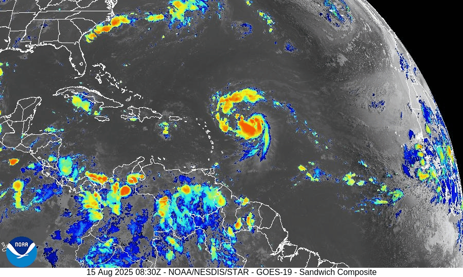
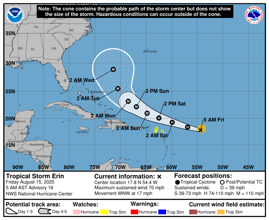
Tropical Storm Erin has intensified, with sustained winds now around 60 mph and tropical storm-force winds extending from a compact core.
Hurricane Hunter aircraft are en route to assess the system. Erin is expected to become a Category 1 hurricane by Friday, with potential escalation to Category 3 (major) over the weekend.Forecast track: Currently on a west-northwest path, Erin is projected to steer northward later and remain offshore of the U.S.–Bahamas corridor, possibly passing near Bermuda. Direct U.S. land impacts are unlikely, but marine hazards will increase.


Gulf of Mexico & Caribbean Conditions
Invest 98L (Bay of Campeche): The disturbance now carries a 40% chance of development over 48 hours and 20% over 7 days. Although tropical cyclone formation is not expected, heavy rain and elevated coastal flooding risk (including rip currents) continue for South Texas.
Caribbean Sea: Stable with typical trade-wind rains and no organized tropical systems.
GOES-19 - Sector view: Gulf of America - Sandwich
GOES-19 - Sector view: Caribbean - Sandwich
Florida & Southeast Forecast
Florida: Persistent heat and humidity prevail with typical afternoon sea‑breeze thunderstorms. These storms are non-tropical in nature.
Marine Impact from Erin: Long-period swells and rip currents will begin affecting East Coast beaches, especially in Florida and the Southeast, as Erin intensifies. Coastal vigilance is advised.
Rain forecast visualization courtesy of Windy.com
Environmental Analysis
Sea Surface Temperatures: Warm—ranging from 84°F to 88°F—support rapid intensification of Erin.
Wind Shear & Atmospheric Moisture: Shear is forecast to decrease and mid-level moisture is sufficient, favoring intensification. Meanwhile, dryness and SAL (Saharan dust) remain more prevalent in other parts of the MDR, limiting additional activity.
Summary & Preparation Notes

Erin is nearing hurricane strength and likely to reach major category. Track keeps it offshore, but surfers and beachgoers should prepare for dangerous surf and rip currents.
Invest 98L will deliver rain to Mexico and South Texas; expect localized flooding.
No immediate threats to Florida or the U.S., but this weekend’s marine hazards are real.
Use this time to confirm emergency plans, especially for any coastal or marine activities.
TL;DR – August 15, 2025
Erin strengthening fast—on track to become a hurricane this weekend.
No direct U.S. impact expected, but surge in surf and rip currents along the Southeast coast.
Invest 98L brings rain to South Texas; low development chances.
Florida sees normal summer weather—hot and stormy, but not tropical.
Coastal watch: Swells and rip current impacts rising; stay informed for Hurricane Updates at CAT5Prep.com

Atlantic Hurricane Outlook – July 21, 2025: Tropics Active with Waves, But No Imminent Threats
The Atlantic remains cyclone-free, but several tropical waves are moving across the basin. Conditions are gradually becoming more favorable for development as July progresses.
The tropical Atlantic is becoming increasingly active, with multiple tropical waves progressing westward across the basin. While none are expected to develop in the short term, the setup is a reminder that we are entering a more climatologically favorable period for storm formation.
Satellite imagery courtesy of Windy.com
Atlantic Basin Overview: No Cyclones, But Multiple Waves
As of the 8:00 AM EDT update from the National Hurricane Center:
No active tropical cyclones
No systems with high development potential at this time
Disturbance 1: A tropical wave near 40°W is producing scattered convection, but environmental conditions remain only marginally favorable.
Formation chance (7 days): 20%
Movement: West to west-northwest at 10–15 mph
New Wave Introduced: A second tropical wave near 23°W, just offshore of Africa, is showing scattered moderate convection on its southern flank.
Too early to determine development potential, but it will be watched over the coming days.
Monsoon Trough Low: A weak low embedded along the monsoon trough near 08N44W is sparking convection, but not currently organized.
NOAA/NESDIS/STAR – GOES-19 Air Mass Composite – July 21, 2025
Sea Surface Temperatures (SSTs): Still Warm
Gulf of Mexico: 86–88°F – well above average
Western Caribbean: 85–87°F – supportive of development
Main Development Region (MDR): 82–84°F and climbing, with warm anomalies persisting
Warm waters throughout the basin provide the necessary energy for storms should other conditions align.
Sea Surface Temperature data courtesy of Windy.com
Wind Shear and Atmospheric Conditions

Wind Shear Courtesy of https://tropic.ssec.wisc.edu/
Shear remains moderate across much of the central and eastern Atlantic but is expected to weaken later in the week.
Moisture levels continue rising, particularly in the MDR and Caribbean.
Saharan Air Layer (SAL): Still present but beginning to thin slightly, particularly west of 40°W.
These factors collectively suggest improving potential for storm development by late July or early August.
Relative Humidity (ECMWF) data courtesy of Windy.com
Saharan Air Layer (Dust) data courtesy of Windy.com
Gulf of Mexico & Caribbean Outlook
A surface trough remains in the eastern Bay of Campeche, producing scattered thunderstorms.
Light to moderate winds (10–15 kt) dominate much of the Gulf, with seas around 3–5 feet.
Fresh winds (15–20 kt) and higher seas (6–8 ft) continue across parts of the south-central Caribbean.
Expect stronger trades and more convection near the Windward Passage and central Caribbean midweek as a tropical wave enters the region.
Wave height forecast (ECMWF Waves) courtesy of Windy.com
Surface pressure data (ECMWF) courtesy of Windy.com
Florida Forecast
Highs: Upper 80s to low 90s°F
Humidity: High
Rain Chances: Scattered afternoon thunderstorms, driven by sea breezes and instability
Winds: Light and variable, turning southeast near the coast
Hazards: Isolated strong storms possible with gusty winds and localized flooding
Rainfall forecast (ECMWF) courtesy of Windy.com
Prep Tip of the Day: Update Insurance and Inventory
Use this lull to get your disaster documentation in order:
Review your homeowners or renters insurance policy
Document your belongings via photos or video
Store digital backups in the cloud
Know your flood zone and verify your flood insurance coverage
Looking Ahead: Tropics Warming Up
While no tropical cyclone development is expected in the next 7 days, the overall pattern is becoming more favorable. Multiple waves in the deep tropics bear watching, and model guidance hints at potential activity in early August. We'll continue monitoring all waves for signs of organization.
Stay informed, stay prepared, and check back daily for updates from Cat5Prep.com.

Atlantic Hurricane Outlook – June 4, 2025: A Flicker on the Horizon
Though no storms are active, key hurricane ingredients are aligning fast. A developing low near the Southeast U.S. and rising SSTs suggest change is coming.
The fourth day of the 2025 Atlantic hurricane season opens with quiet skies—but a subtle shift is underway. For the first time this season, the National Hurricane Center (NHC) has flagged a potential area of interest offshore the southeastern United States. While development chances remain low, it’s a reminder that conditions are evolving and the atmosphere is beginning to stir.

Atlantic Basin: A New Watch Zone Emerges
As of this morning’s Tropical Weather Outlook from the NHC:
No active tropical cyclones
One area of interest off the Southeastern U.S. coast
No tropical development expected in the next 48 hours
Low (10%) chance of development over the next 7 days
A non-tropical low pressure area is forecast to form near or offshore the Southeast U.S. coast.
If it remains offshore, it may gradually acquire subtropical or tropical characteristics while drifting northeastward at 10–15 mph.
— NHC Forecaster Reinhart, June 4, 2025
No storm is expected soon—but it’s the first official mention of potential development this season.
Satellite imagery courtesy of Windy.com
Sea Surface Temperatures: Ready for Action
Warm waters across the Atlantic basin continue to deepen—creating an ideal foundation for future storm formation:
Gulf of Mexico: Running 2–4°F above average, with pockets exceeding 86°F (30°C)
Western Caribbean: SSTs remain high, particularly around Central America and Cuba
Main Development Region (MDR): Trending warmer than normal with gradual warming expected into late June
This warm ocean water is the primary energy source for hurricanes—and it’s already in place.
Sea surface temperature data courtesy of Windy.com
Wind Shear & Moisture: Storm Barriers Continue to Erode
Atmospheric conditions are shifting in a storm-friendly direction:
Wind shear is weakening in key zones like the Gulf and Caribbean
Moisture levels are rising at both low and mid-levels of the atmosphere
Vertical instability is increasing, supporting larger, longer-lasting thunderstorms
This transition increases the likelihood that disorganized storms could become organized systems.

Wind Shear Courtesy of https://tropic.ssec.wisc.edu/
Saharan Air Layer: Still a Barrier, But Fading
A broad plume of Saharan dust remains in the central and eastern Atlantic, offering temporary protection:
Suppresses convection
Inhibits thunderstorm growth
Raises wind shear and dry air intrusion
However, models show this SAL influence weakening by mid-to-late June, removing one of the final natural inhibitors.
Saharan Air Layer data courtesy of Windy.com
Thunderstorm Activity: Early Clues
Even in the absence of tropical storms, convective activity gives us clues about what's forming:
Western Caribbean & Bay of Campeche: Disorganized clusters of thunderstorms show signs of persistent convection
Southeastern U.S. Coast: Isolated convection associated with the developing non-tropical low
While nothing is organizing yet, this pattern often precedes early-season development.
Thunderstorm data courtesy of Windy.com
Florida Forecast: Muggy Mornings, Stormy Afternoons
Expect typical summer conditions today across the state:
North Florida: Highs in the upper 80s, mostly sunny, low humidity
Central Florida: Around 90°F, with isolated thunderstorms after 2 PM
South Florida: Mid-80s, high humidity, with a greater risk of scattered PM storms
Afternoon thunderstorms are normal—but they also signal increasing moisture and instability across the region.
Forecast radar data courtesy of Windy.com
Prep Tip of the Day: Snap and Store
With one system on the radar, now’s a good time to check off a simple but essential task:
📸 Take photos of your home, car, and valuables
☁️ Back up those images to the cloud or email them to yourself
🔒 These photos may be critical for insurance documentation after a storm
Also:
Review your hurricane kit and evacuation plan
Sign up for emergency text alerts from local agencies
Bookmark trusted resources like Cat5Prep.com and hurricanes.gov
Looking Ahead: A Season Starting to Stir
It’s still early in the season, but we’re beginning to see motion on the map:
Warm water and shifting winds are laying the groundwork
The Saharan Air Layer is fading
Thunderstorm activity is creeping into critical regions
Today’s 10% chance of development is low—but it may mark the quiet season’s turning point.
We'll continue tracking changes in the Atlantic and bring you updated guidance each day.
Check back tomorrow for your next hurricane update from Cat5Prep.com.