
Atlantic Hurricane Outlook – October 9, 2025
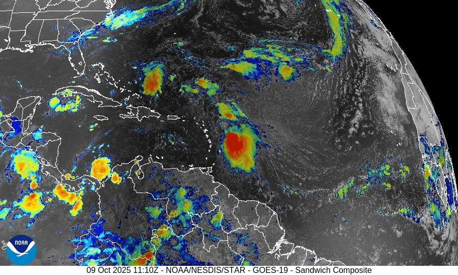
On October 9, Tropical Storm Jerry continues to strengthen in the central Atlantic with sustained winds near 65 mph. The storm is forecast to become a hurricane within 24–48 hours as it tracks west-northwest toward the northern Leeward Islands. Meanwhile, a disturbance in the Bay of Campeche carries only a 10% development chance. Florida and the Gulf of America remain calm aside from elevated surf and rip currents.

Tropical Storm Jerry continues west-northwest; likely intensification ahead; Gulf disturbance still low probability
Atlantic Basin Overview
Tropical Storm Jerry
Jerry remains active in the Atlantic, located about 355 miles east-southeast of the northern Leeward Islands, moving west-northwest at ~20 mph, with sustained winds near 65 mph.
The system is expected to strengthen into a hurricane by Friday or Saturday, as conditions favor further intensification.
A tropical storm watch is in effect for islands such as Antigua, Barbuda, and St. Kitts as Jerry approaches.Gulf / Bay of Campeche Disturbance
A broad area of showers and thunderstorms continues in the Bay of Campeche with only a 10% chance of development per current outlooks over the next 48 hours and 7 days.
Environmental Conditions
Sea Surface Temperatures (SSTs):
SSTs ahead of Jerry remain warm enough to support further strengthening into a hurricane, particularly over the central Atlantic.Wind Shear:
Moderate wind shear is present and may temper the rate of intensification, but not enough to prevent Jerry from likely becoming a hurricane under favorable alignment.Humidity & Dry Air / SAL (Saharan Air Layer):
Dry air and Saharan dust remain in portions of the eastern Atlantic, and these factors may limit convective expansion on Jerry’s flanks. The core appears better insulated from these effects currently.
Gulf of America & Caribbean
These regions remain relatively quiet. The Bay of Campeche disturbance is not expected to develop substantially, and no other tropical systems are showing strong signs of formation.
Florida & Eastern U.S. Forecast
Florida and the broader Eastern U.S. remain outside the immediate threat zone of Jerry. However:
Coastal and marine areas should remain alert for increasing surf, rip currents, and ocean swells as Jerry intensifies.
If Jerry curves northward later, Eastern U.S. coasts—especially the islands and the Leeward chain—could face tropical storm forces and heavy rain.
Inland Florida continues typical early-October weather: humidity, scattered storms, and localized downpours.
Rain forecast visualization courtesy of Windy.com

TL;DR – October 9 Snapshot
Jerry is intensifying, moving WNW, with top winds ~65 mph and is expected to become a hurricane soon.
The Bay of Campeche disturbance remains weak, with only 10% development odds.
SSTs support intensification; moderate shear and dry air may limit strength on the periphery.
Gulf of America and Caribbean remain calm.
Florida and U.S. East Coast currently face no direct land threat, but marine impacts are ongoing and may increase.
Atlantic Hurricane Outlook – October 6, 2025
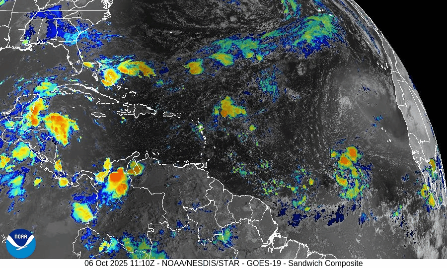
On October 6, a tropical disturbance in the central Atlantic maintains a 70% chance of development according to the National Hurricane Center. The system remains disorganized but is moving through warm waters conducive to gradual formation. Environmental factors like dry air and moderate wind shear are slowing intensification. Florida and the Gulf of America remain free of direct tropical threats.

No active tropical systems; a disturbance in the central Atlantic bears watching
Atlantic Basin Overview
No Active Tropical Cyclones
Currently there are no named storms or hurricanes in the Atlantic, Caribbean, or Gulf of America per the latest NHC outlook.Disturbance Under Monitoring
The NHC continues to track a tropical wave / disturbance in the central Atlantic with increasing organization and favorable parameters. This system retains a 70% chance of tropical development over the next 7 days as earlier reported.
Environmental Conditions
Sea Surface Temperatures (SSTs):
SSTs across much of the tropical Atlantic and the disturbance’s projected path remain warm, generally supportive for development if other conditions align.Wind Shear:
Elevated vertical wind shear remains a limiting factor across broad parts of the Atlantic. That shear may slow intensification or disrupt organization of the monitored disturbance.Humidity & Dry Air / SAL:
Mid-level dry air and Saharan dust intrusions persist in portions of the basin. Those dry air inclusions and SAL effects continue to suppress convective vigor in developing systems, especially farther east.
Gulf of America & Caribbean
The Gulf of America and Caribbean basins remain quiet. No tropical systems are forming at present; convection is limited to normal seasonal showers and thunderstorms.
Florida & Eastern U.S. Forecast
Florida and the Eastern U.S. are currently not under direct tropical threat. The disturbance is positioned well east of the region. The main concern along the Atlantic coast continues to be elevated surf, swells, and rip current risk, especially if the disturbance develops and enhances ocean motion.
Rain forecast visualization courtesy of Windy.com

TL;DR – October 6 Snapshot
No active storms at the moment.
A central Atlantic disturbance holds a 70% 7-day development chance.
SSTs are favorable; shear and dry air are still challenges.
Gulf of America and Caribbean are quiet.
Florida/Eastern U.S.: no direct threat; marine conditions (surf/rip currents) remain the main hazard.
Atlantic Hurricane Outlook – October 2, 2025
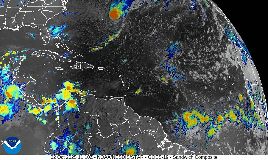
On October 2, Hurricane Imelda has weakened to Category 1 while racing east-northeast away from Bermuda after bringing damaging winds and power outages to the island. Humberto has transitioned into an extratropical system, but swells and rip currents will persist along the U.S. East Coast. Environmental factors—cooler waters, rising wind shear, and Saharan dust—are driving Imelda’s decline and limiting new development. Florida and the Gulf of America remain quiet.

Imelda weaker but still impactful; Humberto dissipates; hazardous marine conditions persist
Atlantic Basin Overview
Hurricane Imelda
Imelda passed near Bermuda, causing widespread power outages, downed trees, and strong winds. It has since weakened to Category 1 status with sustained winds near 80 mph and is moving east-northeast at 30 mph. No U.S. landfall is expected as Imelda continues to track away.Hurricane Humberto
Humberto has merged with frontal systems and lost tropical characteristics, transitioning into an extratropical cyclone. Its circulation is no longer classified as a hurricane, though its remnant energy continues contributing to swells and marine hazards along the Atlantic.Other Disturbances / Waves
Additional Atlantic waves are being watched, but none currently show robust development or trajectories toward U.S. coasts under present forecasts.
Environmental Conditions
Sea Surface Temperatures (SSTs):
SSTs near Imelda and Bermuda remain warm enough to support tropical cyclone strength, but cooler waters lie ahead along its projected path, which will continue to weaken it.Wind Shear:
Vertical wind shear is increasing across Imelda’s circulation, eroding convection and weakening structural organization.Humidity & Dry Air / SAL:
Dry mid-level air and dust from the Saharan Air Layer are penetrating outer bands and suppressing convection, especially in weaker waves farther east. These factors continue to restrict new storm development.
Gulf of America & Caribbean
The Gulf of America and Caribbean remain quiet, with no organized tropical systems. Shower and thunderstorm activity is typical for early October, but no tropical threats are present.
Florida & Eastern U.S. Forecast
Florida and the Southeast U.S. are not expected to see a tropical landfall from Imelda. However, the East Coast continues to experience dangerous surf, strong rip currents, and elevated coastal flooding potential, driven by Imelda and Humberto’s residual swell energy.
Rain forecast visualization courtesy of Windy.com

TL;DR – October 2 Snapshot
Imelda is now a Category 1 hurricane, weakening as it moves away from Bermuda.
Humberto has lost its tropical nature and is now extratropical.
Warm SSTs support Imelda, but increasing shear and dry air accelerate weakening.
Gulf of America and Caribbean remain calm.
U.S. East Coast should continue monitoring marine conditions—surf and rip currents remain the main hazard.


Atlantic Hurricane Outlook – September 26, 2025
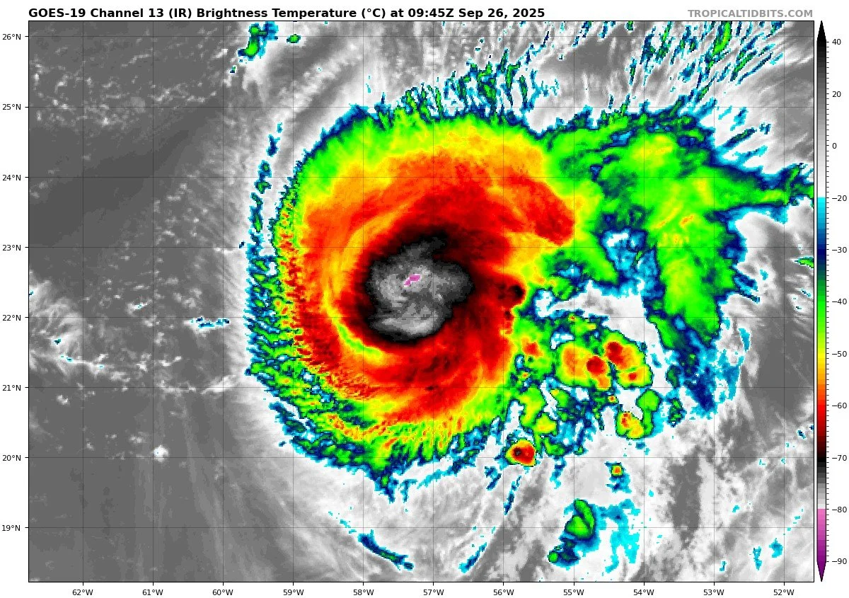
On September 26, Gabrielle has weakened into a post-tropical cyclone near the Azores, where hurricane warnings remain in effect. Dangerous swells and rip currents continue along the U.S. East Coast. Meanwhile, Hurricane Humberto has strengthened in the open Atlantic, though no U.S. land impacts are expected. Environmental factors—cooler waters, stronger shear, and Saharan dust—are weakening Gabrielle and suppressing other waves. Florida and the Gulf of America remain quiet.

Gabrielle transitions to post-tropical near the Azores; Humberto strengthens in the Atlantic
Atlantic Basin Overview
Post-Tropical Cyclone Gabrielle
Gabrielle has weakened and become a post-tropical cyclone, located near 39.1°N, 26.1°W, moving east-northeast at about 29 mph with maximum sustained winds near 65 mph. The system is still producing tropical-storm conditions with gusts to hurricane force across parts of the Azores, where a hurricane warning remains in effect. Gabrielle will continue to weaken as it tracks into cooler waters, transitioning fully into an extratropical system.Hurricane Humberto
Humberto has strengthened into a hurricane northeast of the Leeward Islands. Forecast guidance suggests continued intensification in the coming days. Current tracks keep Humberto over the open Atlantic, posing no direct threat to the U.S. East Coast or Florida at this time.Other Disturbances / Waves
The NHC is also monitoring additional tropical waves across the Atlantic. None are currently organized, and environmental conditions are not favorable for rapid development.
Hurricane HUMBERTO
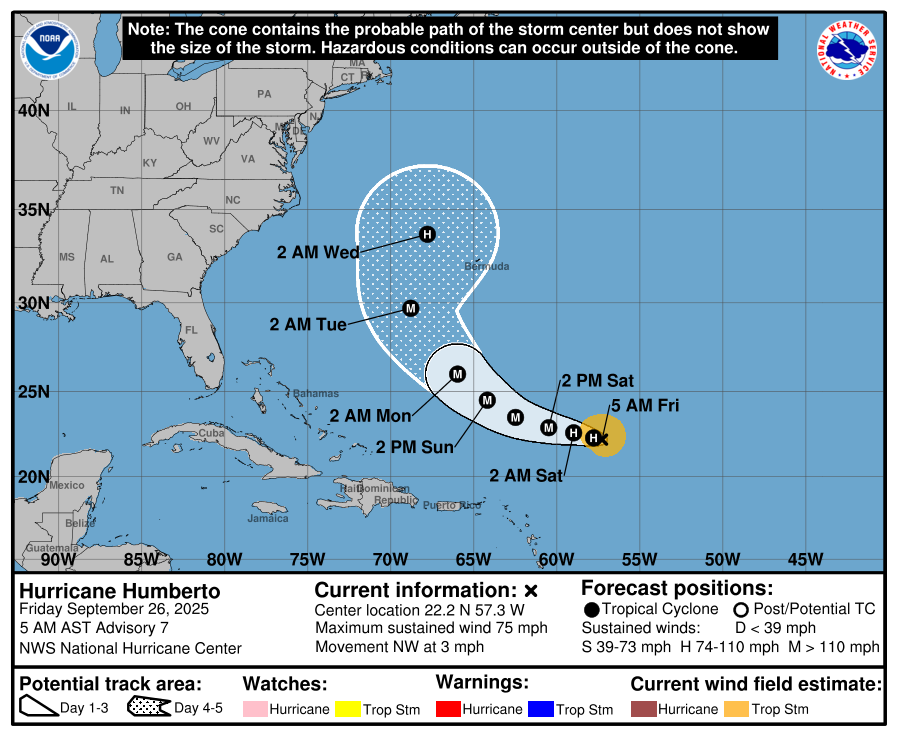


Invest 94L


Environmental Conditions
Sea Surface Temperatures (SSTs): SSTs remain supportive in parts of the Atlantic, helping maintain Humberto’s strength. Gabrielle is moving into cooler waters, which is contributing to its weakening trend.
Wind Shear: Increasing wind shear is disrupting Gabrielle’s structure and will continue to suppress further organization. Humberto is in a more favorable low-shear environment, aiding intensification.
Humidity & Dry Air (SAL): Mid-level dry air and Saharan Air Layer dust continue to suppress convection in the eastern Atlantic, limiting development for weaker tropical waves.
Gulf of America & Caribbean
The Gulf of America and Caribbean remain calm, with no organized tropical systems. Scattered thunderstorms and late-summer showers continue, but there are no signs of tropical development.
Florida & Eastern U.S. Forecast
Florida remains free of any tropical threats. The primary hazard along the Eastern U.S. coastline comes from Gabrielle’s swells, which are still producing dangerous surf and rip currents along Atlantic beaches. Inland Florida continues with typical hot, humid late-September weather and scattered afternoon thunderstorms.
Rain forecast visualization courtesy of Windy.com

TL;DR – September 26 Snapshot
Gabrielle is now a post-tropical cyclone, still impacting the Azores but weakening.
Humberto has intensified into a hurricane, tracking safely over the open Atlantic.
SSTs support Humberto, while wind shear and dry air weaken Gabrielle and limit other waves.
Gulf of America, Florida, and Eastern U.S. face no direct tropical threats; main concern remains marine hazards from swell and rip currents.

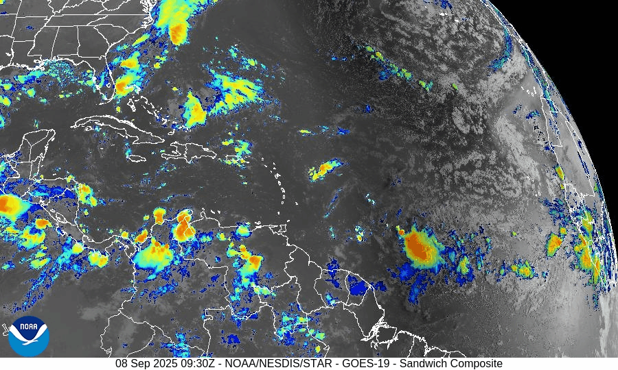
Atlantic Hurricane Outlook – September 8, 2025
On September 8, the Atlantic remains storm-free with no tropical systems active. Two weak tropical waves are producing scattered showers but lack organization, and the National Hurricane Center expects no development over the next week. Florida and the Gulf of Mexico remain calm, experiencing only the usual late-summer heat, humidity, and afternoon thunderstorms.

TLDR Version: Click Here
Atlantic basin remains calm — no tropical development expected this week
Atlantic Basin Overview
No Active Systems
The Atlantic, Caribbean, and Gulf of America (Mexico) remain free of tropical cyclones. The National Hurricane Center does not expect any development over the next 7 days.
Tropical Waves Present but Inactive
A wave near 20°W, east of the Cabo Verde Islands, is producing scattered showers but is not expected to organize.
Another wave between 41°W and 47°W in the central Atlantic shows some convection but remains disorganized.
Environmental Conditions
Sea Surface Temperatures (SSTs): Warm in the Gulf and Caribbean (~29–31 °C), but cooler in the open Atlantic, limiting storm growth.
Wind Shear: Moderate to strong across much of the basin, unfavorable for storm organization.
Dry Air & SAL: The Saharan Air Layer and widespread dry mid-level air continue to suppress deep convection and tropical development.
Gulf of America (Mexico) & Caribbean
The Gulf remains quiet and stable, with only routine afternoon sea-breeze thunderstorms. No tropical development is expected.
Florida & Southeast U.S. Forecast
Florida stays in its late-summer pattern of heat, humidity, and scattered afternoon thunderstorms. No tropical threats are present this week.
Rain forecast visualization courtesy of Windy.com

Summary
The Atlantic is inactive, with no storms or new development expected.
Two tropical waves are noted, but neither shows potential for near-term organization.
Environmental conditions remain unfavorable across the basin, with shear, dry air, and SAL dominating.
The Gulf and Florida remain calm, with only routine late-summer weather.
TL;DR – September 8 Snapshot
No storms in the Atlantic.
A couple of weak tropical waves, but no organization.
Shear, dry air, and SAL continue to suppress development.
Gulf and Florida remain quiet with typical afternoon thunderstorms.

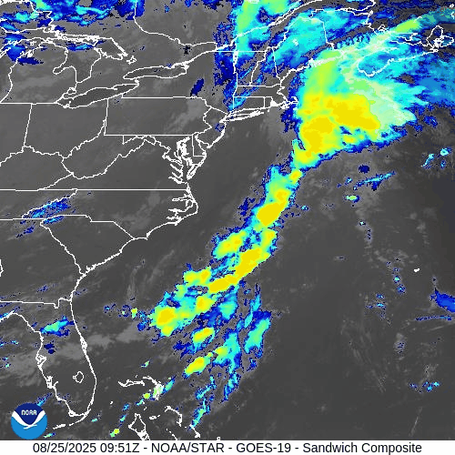
Atlantic Hurricane Outlook – August 25, 2025
Tropical Storm Fernand continues east of Bermuda with sustained winds near 50 mph and will weaken as it moves into cooler waters. Erin’s legacy swells still drive dangerous surf and rip currents from the Carolinas to New England. Florida and the Gulf remain calm, with only routine summer thunderstorms.
TLDR Version: Click Here

Tropical Storm Fernand holds strength offshore; environmental factors limit wider Atlantic development
Atlantic Basin Overview
Tropical Storm Fernand
Fernand is located about 360 miles east-northeast of Bermuda, carrying sustained winds near 50 mph while moving north-northeast at ~12 mph. The system may strengthen slightly today but will soon encounter cooler waters and stronger upper-level winds, leading to weakening and a transition to a post-tropical cyclone by midweek. No coastal warnings are in effect, and Fernand poses no threat to land.
Hurricane Erin’s Legacy
Erin’s powerful circulation has long dissipated, but the swell energy lingers. Beaches from the Carolinas to New England remain at risk for dangerous rip currents, elevated surf, and localized erosion, even as skies improve inland.
Other Atlantic Activity
A tropical wave in the Caribbean and another in the central Atlantic show low development chances. The NHC assigns only a 10% probability of tropical formation through 7 days. Dry air and hostile shear continue to suppress organization.
Gulf of America (Mexico) & Caribbean
The Gulf is quiet under high pressure with only routine afternoon thunderstorms along the coast. Very warm waters (29–31 °C) cover the basin, but no tropical development is expected in the near term.
Florida & Southeast U.S. Forecast
Florida remains locked in a late-August cycle: hot, humid conditions and scattered afternoon thunderstorms driven by the sea breeze. Some areas also see morning showers drifting in from the Gulf, making for a two-phase rain pattern.
No tropical threats are present, but Atlantic beaches continue to face rip current risks due to Fernand’s swells and Erin’s lingering wave action.
Rain forecast visualization courtesy of Windy.com
Environmental Conditions
Sea Surface Temperatures (SSTs): The Caribbean and Gulf of Mexico are running 29–31 °C (84–88 °F), supportive of development. In the western Atlantic, SSTs are warm enough to sustain Fernand briefly, but cooler waters to the north will drive weakening.
Wind Shear: Currently low to moderate around Fernand, allowing some maintenance of strength. However, increasing shear northward will disrupt convection and hasten its post-tropical transition. Shear also remains moderate to strong across much of the MDR, suppressing other disturbances.
Mid-Level Relative Humidity (RH): Dry air pockets persist in the central Atlantic, limiting organization of Invest 99L and other waves. Moisture is more favorable closer to the Caribbean and Gulf.
Saharan Air Layer (SAL): SAL dust continues to intrude across parts of the eastern and central Atlantic, reducing convection and capping development potential.
Summary

Fernand is a 50 mph tropical storm, staying well offshore and weakening by midweek.
Erin’s swells continue to fuel dangerous surf and rip currents along the East Coast.
Environmental conditions (SSTs supportive, but SAL, dry mid-level air, and increasing shear) are limiting further Atlantic development.
Gulf and Florida remain quiet, aside from routine thunderstorms and coastal surf hazards.
TL;DR – August 25 Snapshot
Fernand stays offshore, no U.S. land threat, weakening soon.
Rip currents and surf hazards linger along the East Coast.
SAL, shear, and dry mid-level air suppress new storm formation.
Gulf and Florida remain in a routine summer pattern.
As always, check back at CAT5Prep.com for daily hurricane updates, and also visit our Hurricane Prep Blog to find ways you can prepare during hurricanes.
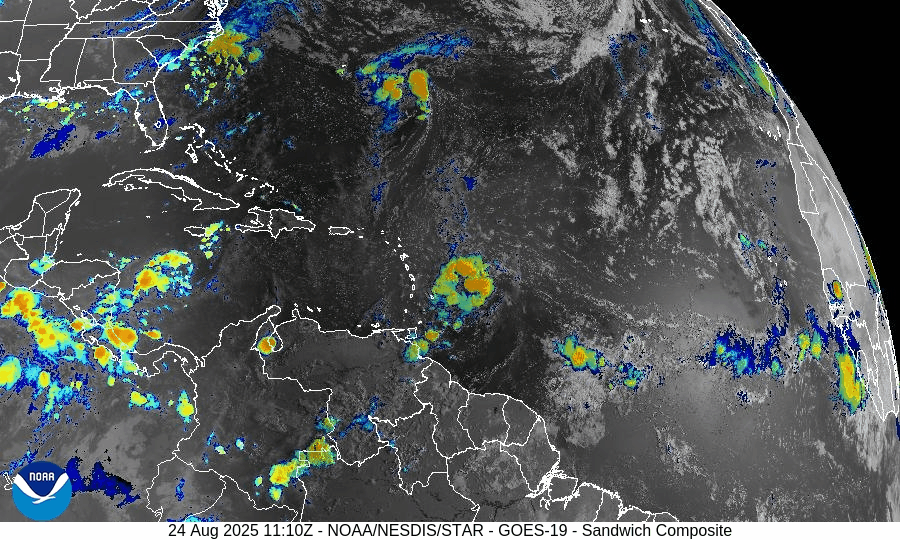
Atlantic Hurricane Outlook – August 24, 2025: Tropical Storm Fernand forms southeast of Bermuda
Tropical Storm Fernand has developed in the Atlantic while Erin’s post-tropical remnants continue to generate hazardous surf and rip currents from the Carolinas to New England. Florida and the Gulf of Mexico remain calm, with only daily sea-breeze thunderstorms expected.
TLDR Version: Click Here

Tropical Storm Fernand forms southeast of Bermuda; environmental conditions shaping its strength and lifespan
Atlantic Basin Overview
Tropical Storm Fernand
A new system, Tropical Storm Fernand, has formed approximately 300–400 miles southeast of Bermuda, with sustained winds near 40 mph and moving north-northeastward at about 15 mph. Forecasts support gradual strengthening, possibly into a hurricane by Monday, before weakening as it encounters cooler waters and increasing wind shear. The projected path keeps Fernand well east of Bermuda and away from land. Multiple long-period swells from Fernand, combined with Erin’s lingering effects, sustain hazardous surf and rip current risks along the U.S. East Coast.
Hurricane Erin’s Lingering Hazards
Although Erin has been post-tropical for days, its legacy endures in dangerous surf and life-threatening rip currents from the Carolinas through New England. Earlier in the week, dune breaches, NC‑12 flooding, and evacuations in the Outer Banks were documented. The ocean hazards persist even as the system moves further away.
Invest 99L
A tropical wave in the central Atlantic (Invest 99L) continues to show only limited organization. Environmental conditions—particularly dry mid-level air and moderate wind shear—are hindering its development.
Environmental Conditions
Sea Surface Temperatures (SSTs): SSTs across the Caribbean and Gulf remain warm (29–31 °C / 84–88 °F), which generally fuels storm development. The Main Development Region (MDR) is also running near or slightly above average SSTs, offering environmental support for intensification.
Wind Shear: As of today, Fernand benefits from light wind shear in the immediate area of formation, although models show increasing wind shear after ~36 hours, which should weaken the system. Moderately high shear in the Caribbean and central Atlantic continues to suppress broader basin-wide development.
Mid-level Humidity & Saharan Air Layer (SAL): While overall moisture in the western tropical Atlantic remains sufficient, pockets of dry mid-level air—partly due to lingering SAL intrusions—are inhibiting storm convection and formation in some areas, including near Invest 99L.
Gulf of America (Mexico) & Caribbean
The Gulf of America (Mexico) remains quiet, with high pressure dominating. Standard afternoon sea-breeze thunderstorms continue along the coast, but no organized tropical development is expected in the near term. SSTs remain very warm (29–31 °C), making the region climatically conducive to storm formation later in the season.
Florida & Southeast U.S. Forecast
Across the Florida Peninsula, it's the usual late-August pattern: hot and humid, with daily sea-breeze thunderstorms. Afternoon rainfall, frequent lightning, and gusty winds persist. No tropical threats are present at this time.
Along the Atlantic coast from Florida to New England, rip current risk remains elevated due to swells generated by both Erin and Fernand. Hazards are expected to continue into early next week—beachgoers should remain cautious and heed local advisories.
Rain forecast visualization courtesy of Windy.com
Summary

Fernand has formed southeast of Bermuda and is expected to strengthen briefly while remaining over open water; weakening is likely within a few days.
Erin’s remnants continue to produce dangerous coastal surf and rip currents, particularly from the Carolinas northward.
Invest 99L shows low development potential due to hostile environmental conditions, including dry air and moderate shear.
Gulf and Florida remain storm-free, with only routine summertime convection.
TL;DR – August 24 Snapshot
Fernand forms and may briefly become a hurricane, but stays out at sea.
Hazardous surf and rip currents continue along the U.S. East Coast from Erin’s legacy.
Development of Invest 99L is stunted by dry air and moderate shear.
Gulf of Mexico and Florida remain calm, with season-typical afternoon storms only.