
Atlantic Hurricane Outlook – August 6, 2025: Dexter Weakens Over Open Atlantic; Two Systems Now Under Watch
Tropical Storm Dexter continues weakening in the open Atlantic, while two systems—off the Southeast U.S. coast and near Africa—are now under watch. SAL and wind shear are still limiting major development, but warm SSTs raise future potential.
*Those who like data, continue reading. Those it prefer the quick version, jump to the TL;DR here.
Tropical Storm Dexter continues moving northeast and weakening, while the National Hurricane Center is now monitoring two additional disturbances—one off the Southeast U.S. coast and another tropical wave across the eastern Atlantic—with modest development potential over the coming week.
Atlantic Basin Status
Tropical Storm Dexter is currently well north of Bermuda, sustained winds near 40–45 mph, moving east-northeast at ~13 mph. It's expected to transition to a post-tropical cyclone by mid-week and present no threat to land.
Disturbance near Southeast U.S. coast (“Invest AL95”): Located offshore of Florida, now has a 40% development chance over the next 7 days. While significant intensification is unlikely, it may bring increased rain and marine impacts along the Mid-Atlantic and Southeast coastal areas.
Tropical wave near ~30°W off Africa: Moving west-northwest, scattered convection observed. NHC assigns a 50% chance of development within 7 days, as it enters warmer seas and potentially weaker shear zones.
Key Environmental Conditions
Sea Surface Temperatures (SSTs): Gulf and Caribbean waters remain very warm (29–31 °C), offering the thermal fuel necessary for storm development as conditions evolve.
Wind Shear: Moderate to high shear prevails across much of the central Atlantic, limiting organization of existing systems. Models hint that shear may ease near the western MDR later this month.
Saharan Air Layer (SAL): A dry, dusty SAL plume still covers much of the eastern and central Atlantic, suppressing mid- to upper-level moisture and inhibiting thunderstorm persistence.
Atmospheric Moisture: Improving across the western basin, especially near the Caribbean, though heavy dry air remains in many parts of the Atlantic.
Gulf & Caribbean Update
No disturbances in the Gulf or Caribbean seas.
High-pressure dominance maintains generally dry conditions, with scattered showers typical of early August.
Expect stable marine conditions without organized tropical activity.
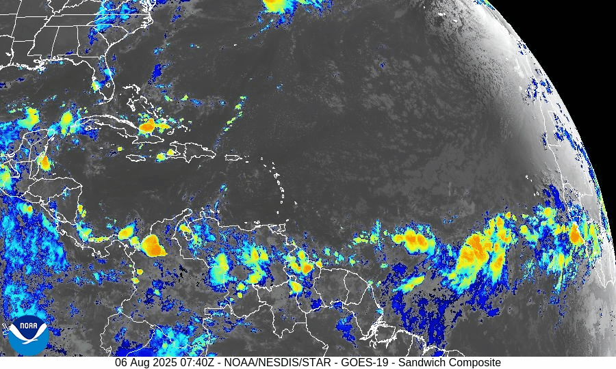
GOES-19 - Sector view: Gulf of America - Sandwich
GOES-19 - Sector view: Caribbean - Sandwich
Florida Forecast
Temperature & Humidity: Highs near 90°F under humid, muggy conditions.
Rain Chances: 40–50% for afternoon thunderstorms powered by sea breeze activity—not tropical in nature.
Winds: Light and variable inland, becoming southeast near the coast.
No tropical threats are expected to impact Florida today.
Rain forecast visualization courtesy of Windy.com
Prep Tip for the Day: Monitor Beach & Marine Conditions
Though Dexter is offshore, it is generating dangerous rip currents along the U.S. East Coast—from Florida through New England. Stay behavior-aware and heed coastal safety warnings even without landfall forecast.
Outlook
Dexter is weakening but remains watchable over open waters. The disturbance off Florida and the wave from Africa are the two main areas of tropical interest, each with moderate development odds this week. Persistent SAL and shear are still limiting, but conditions may shift toward favorability as August evolves.
TL;DR – August 6 Summary
Dexter weakening, staying over the open Atlantic.
Disturbance near Florida coast: 40% chance of development, may bring rain and marine effects.
Wave off Africa (~30°W): 50% development odds in 7 days.
Warm SSTs support activity, but SAL and wind shear remain inhibitory.
No immediate threats to Florida; hazardous rip currents possible.
Watch conditions as hurricane season builds toward mid‑August.
Stay prepared and stay informed — daily updates available at Cat5Prep.com.

Atlantic Hurricane Outlook – June 10, 2025: Quiet Continues, But Observers Stay Alert
No storms in sight, but sea surface temperatures continue to rise and wind shear is gradually easing—signs that the quiet start to the 2025 hurricane season may not last.
The tenth day of the 2025 Atlantic hurricane season opens with calm skies and no immediate threats. The latest update from the National Hurricane Center (NHC) confirms no active systems and no expected tropical cyclone formation over the next seven days. Early June often starts this way, but with sea surface temperatures climbing and atmospheric factors slowly shifting, vigilance remains important.
Atlantic Basin: No Systems in Sight
No active tropical cyclones
No areas of interest
No development anticipated within 7 days
This outlook aligns with the expected early-season lull, but conditions are steadily changing.
Satellite data courtesy of Windy.com
Sea Surface Temperatures: Warming Trend Continues
Gulf of Mexico & Western Caribbean: Still in the low to mid‑80s °F (around 27–29 °C), ideal for fueling storms when other factors permit
Main Development Region (MDR): Running warmer than average for early June—enough to support development later this month
These warm waters are critical as the season progresses.
Sea Surface Temperature data courtesy of Windy.com
Atmospheric Conditions: Mixed Signals
Wind Shear: Moderate to high across much of the basin, particularly within the western Caribbean and central Atlantic—limiting today’s storm potential
Moisture: Mid-level moisture appears to be on the rise, which could support future thunderstorm activity

Wind Shear Courtesy of https://tropic.ssec.wisc.edu/
Saharan Air Layer: A Dry Deterrent
A robust plume of Saharan dust continues to suppress tropical wave development across the eastern Atlantic and MDR
This dry layer is expected to ease by late June, removing one of the key early-season inhibitors
Saharan Air Layer data courtesy of Windy.com
Thunderstorm Activity: Routine, Not Tropical
Florida & Southeastern U.S.: Expect isolated afternoon storms typical for June
Western Caribbean: A few disorganized showers and storms—no rotation or organization evident
Atlantic Ocean: Quiet, with no tropical wave activity currently observed
Thunderstorm data courtesy of Windy.com
Florida Forecast (Statewide)
Highs: Upper 80s to low 90s °F (31–33 °C)
Humidity: Moderate to high—classic muggy comfort
Rain: Scattered afternoon/evening showers typical of early summer
Winds: Light and variable
Rain data courtesy of Windy.com
Prep Tip of the Day: Check Evacuation Zones
With time on your side:
Confirm your evacuation zone and review the planned evacuation route
Update your family emergency contact lists
Ensure your NOAA weather radio and mobile alert settings are active
Keep local emergency management contacts accessible
Looking Ahead: Still Quiet, But Watch for Change
While no tropical development is expected this week, underlying conditions are subtly shifting:
Warm ocean waters persist
Atmospheric wind shear is forecast to gradually decrease
Moisture levels are on the rise
Saharan dust is weakening, removing suppression barriers
Early hurricane season often starts quietly—but conditions can change fast. Stay tuned to Cat5Prep.com for daily updates.