
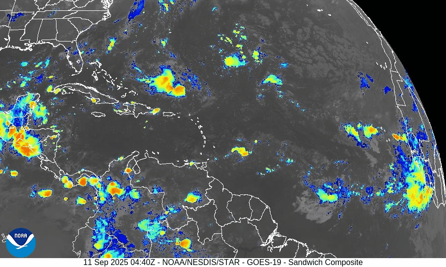
Atlantic Hurricane Outlook – September 11, 2025
On September 11, the Atlantic basin remains storm-free with no active cyclones. A tropical wave emerging off the coast of Africa has been given a 30% chance of development over the next 7 days, though environmental conditions such as wind shear, dry air, and Saharan dust remain unfavorable. The Gulf of Mexico and Florida stay calm, experiencing only typical late-summer thunderstorms.

Atlantic remains calm; weak tropical wave off Africa flagged with low chance (30%) of development over 7 days
Atlantic Basin Overview
No Active Tropical Cyclones
The Atlantic basin, including the Caribbean Sea and Gulf of Mexico, currently has no active tropical storms, hurricanes, or depressions. The NHC outlook confirms no formation expected in the near term.Tropical Wave Off Africa
A tropical wave is forecast to emerge offshore of West Africa by Friday. It will travel west to west-northwest at about 15 mph, over the eastern and central tropical Atlantic. Although conditions may allow for some gradual development, the NHC gives this wave a low chance (near 0%) over the next 48 hours, increasing to 30% over the next 7 days.
Environmental Conditions
Sea Surface Temperatures (SSTs): Warm in the Gulf and Caribbean (29–31 °C), supportive for storm formation there—but in the eastern tropical Atlantic, SSTs are marginal or just adequate for potential development.
Wind Shear: Moderate to high shear persists across much of the Atlantic, making rapid development unlikely.
Dry Air & Saharan Air Layer (SAL): Dry mid-level air and SAL remain strong headwinds for storm formation, especially for any tropical waves nearing the eastern Atlantic.
Gulf of America (Mexico) & Caribbean
Conditions remain quiet and stable. Only routine afternoon thunderstorms are expected along coastal areas, with no tropical system showing signs of organization.
Florida & Southeast U.S. Forecast
Florida continues in its typical early-September weather pattern—hot, humid, and marked by scattered afternoon thunderstorms. With no active systems in the Atlantic, Gulf, or nearby, there are no coastal or tropical threats expected in the short term. Surf and marine conditions are generally benign.
Rain forecast visualization courtesy of Windy.com

Summary
Atlantic is quiet with no active tropical storms.
Weak tropical wave off Africa has ~30% chance of development in 7 days; 0% in the next 48 hours.
Environmental factors (SSTs, shear, dry air/SAL) remain mostly unfavorable.
Gulf and Florida remain calm with routine summer convection.
TL;DR – September 11 Snapshot
No active storms in the Atlantic.
Wave off Africa has low but nonzero chance (30%) of forming in the coming days.
Hostile environment limits quick growth.
Florida and Gulf: quiet, typical late-summer weather.

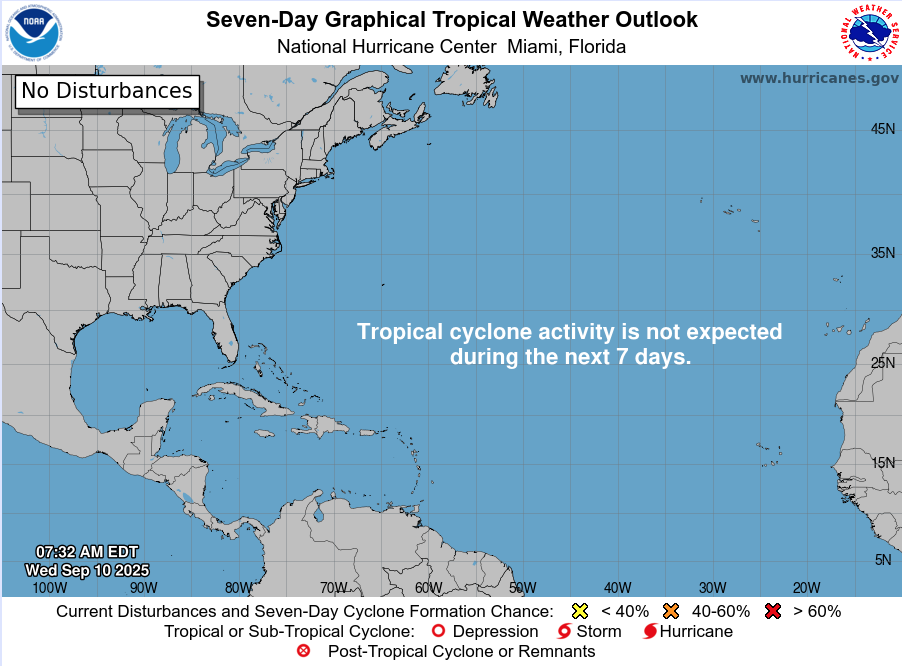
Atlantic Hurricane Outlook – September 10, 2025
On September 10, the Atlantic basin remains calm despite being the statistical peak of hurricane season. No tropical cyclones are active, and the National Hurricane Center does not expect development over the next week. Dry air, Saharan dust, and wind shear are keeping conditions hostile to storm formation. Florida and the Gulf of Mexico remain quiet, with only the typical late-summer pattern of heat, humidity, and afternoon thunderstorms.

Atlantic remains exceptionally calm during climatological peak; no tropical development expected
Atlantic Basin Overview
No Active Systems
Despite reaching the climatological peak of hurricane season (September 10), the Atlantic basin remains completely quiet—no tropical depressions, storms, or hurricanes are present. The National Hurricane Center’s 7-day outlook again shows no expected development.
The season's accumulated cyclone energy (ACE) across the Northern Hemisphere is currently below 60% of average, further emphasizing the unusual lull.
Last week’s disturbance—once showing high development potential near the Caribbean—dissipated after ingesting dry, dusty air from the Sahara.
Environmental Conditions
Sea Surface Temperatures (SSTs): Subtropics indicate record-warm SSTs, while much of the tropical Atlantic remains cooler than last year, reducing atmospheric instability and suppressing storm formation.
Atmospheric Conditions: Saharan dust plumes and a notably weak lapse rate in the atmosphere continue to inhibit convective development across the basin.
Looking Ahead: Meteorologists anticipate that activity may increase from late September into October. This is driven by the expected arrival of the Madden-Julian Oscillation (MJO) and continuing La Niña trends, both of which tend to support tropical cyclone development.
Gulf of Mexico & Caribbean
No tropical threats are present. High-pressure dominance continues to maintain calm conditions, aside from normal afternoon sea-breeze thunderstorms.
Florida & Southeast U.S. Forecast
Florida remains in its typical late-summer pattern: hot, humid, with scattered afternoon storms. With no tropical systems in the Atlantic or Gulf, no coastal or tropical hazards are expected this week.
Rain forecast visualization courtesy of Windy.com

Summary
The Atlantic basin is quiet, with no storms active or expected over the next 7 days.
Suppressive factors—cooler SSTs, dry air, Saharan dust, and weak atmospheric instability—continue to dominate.
Although conditions are currently unfavorable, model and observational insights suggest a potential pickup in tropical activity later this month as MJO and La Niña factors emerge.
Gulf and Florida remain unaffected, encountering only routine late-summer weather.
TL;DR – September 10 Snapshot
No activity in the Atlantic—still quiet at hurricane season peak.
Atmospheric conditions strongly suppress development: dry air, dust, and cool SSTs.
Climatology points to a possible uptick in activity toward late September/October.
Florida and the Gulf stay quiet—just the usual stormy afternoons.

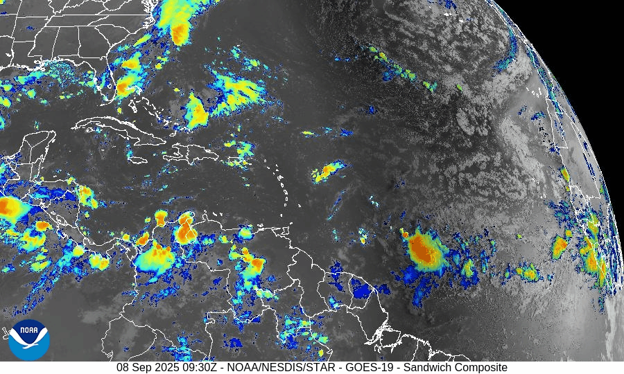
Atlantic Hurricane Outlook – September 8, 2025
On September 8, the Atlantic remains storm-free with no tropical systems active. Two weak tropical waves are producing scattered showers but lack organization, and the National Hurricane Center expects no development over the next week. Florida and the Gulf of Mexico remain calm, experiencing only the usual late-summer heat, humidity, and afternoon thunderstorms.

TLDR Version: Click Here
Atlantic basin remains calm — no tropical development expected this week
Atlantic Basin Overview
No Active Systems
The Atlantic, Caribbean, and Gulf of America (Mexico) remain free of tropical cyclones. The National Hurricane Center does not expect any development over the next 7 days.
Tropical Waves Present but Inactive
A wave near 20°W, east of the Cabo Verde Islands, is producing scattered showers but is not expected to organize.
Another wave between 41°W and 47°W in the central Atlantic shows some convection but remains disorganized.
Environmental Conditions
Sea Surface Temperatures (SSTs): Warm in the Gulf and Caribbean (~29–31 °C), but cooler in the open Atlantic, limiting storm growth.
Wind Shear: Moderate to strong across much of the basin, unfavorable for storm organization.
Dry Air & SAL: The Saharan Air Layer and widespread dry mid-level air continue to suppress deep convection and tropical development.
Gulf of America (Mexico) & Caribbean
The Gulf remains quiet and stable, with only routine afternoon sea-breeze thunderstorms. No tropical development is expected.
Florida & Southeast U.S. Forecast
Florida stays in its late-summer pattern of heat, humidity, and scattered afternoon thunderstorms. No tropical threats are present this week.
Rain forecast visualization courtesy of Windy.com

Summary
The Atlantic is inactive, with no storms or new development expected.
Two tropical waves are noted, but neither shows potential for near-term organization.
Environmental conditions remain unfavorable across the basin, with shear, dry air, and SAL dominating.
The Gulf and Florida remain calm, with only routine late-summer weather.
TL;DR – September 8 Snapshot
No storms in the Atlantic.
A couple of weak tropical waves, but no organization.
Shear, dry air, and SAL continue to suppress development.
Gulf and Florida remain quiet with typical afternoon thunderstorms.

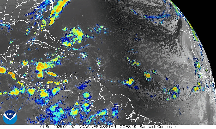
Atlantic Hurricane Outlook – September 7, 2025
On September 7, the Atlantic remains completely calm with no tropical storms or hurricanes. The National Hurricane Center expects no development over the next 7 days. A weak tropical wave in the central Atlantic is producing scattered showers but shows no signs of organization. Florida and the Gulf of Mexico remain quiet, experiencing only typical late-summer thunderstorms.

**We’re back after a series of technical issues. We apologize for the inconvenience.
TLDR Version: Click Here
Atlantic remains quiet with no tropical development expected in the next week
Atlantic Basin Overview
No Active Storms
The Atlantic basin is completely calm—no tropical depressions, storms, or hurricanes are present. The NHC advises that no tropical cyclone formation is expected over the next seven days.Tropical Waves Noted
A central Atlantic wave near 41°W and 17°N, moving west at 10–15 kt, shows scattered moderate convection—but no sign of imminent development.
Environmental Conditions
Sea Surface Temperatures (SSTs): Still warm across the Gulf and Caribbean (~29–31 °C), but less favorable in the open Atlantic.
Wind Shear: Elevated winds aloft continue across the basin, suppressing convective organization.
Mid-Level Humidity & SAL: Dry air and Saharan dust remain widespread, further limiting storm initiation.
Gulf of Mexico & Caribbean
The Gulf remains quiet and stable, with only typical afternoon sea-breeze thunderstorms occurring along coastal areas. No tropical systems are expected to develop.
Florida & Southeast U.S. Forecast
Florida continues under a late-summer pattern—hot, humid, and featuring scattered afternoon thunderstorms. With no systems nearby and improving sea conditions, no enhanced coastal risks are currently expected.
Rain forecast visualization courtesy of Windy.com

Summary
The Atlantic basin remains quiet, with no active systems or expected development in the short term.
Although tropical waves are present, environmental factors (warm SSTs excluded) are largely unfavorable across the basin.
The Gulf and Florida remain unaffected, experiencing only routine summertime weather.
TL;DR – September 7 Snapshot
No storms in the Atlantic; no development expected for 7 days.
A wave in the central Atlantic shows no signs of imminent organization.
Environmental factors continue to suppress new tropical formation.
Florida and Gulf remain calm with only routine weather patterns.

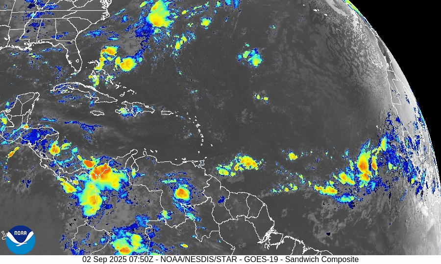
Atlantic Hurricane Outlook – September 2, 2025
On September 2, the Atlantic remains storm-free with no active tropical cyclones. A tropical wave emerging off the coast of Africa shows rising organization and carries a 70% chance of development within 7 days. Environmental conditions are gradually improving, though dry air and Saharan dust remain factors. The Gulf of Mexico and Florida stay calm with only typical early-September thunderstorms.

TLDR Version: Click Here
Atlantic remains quiet; African wave gaining strength with a 70% 7-day development chance
Atlantic Basin Overview
No Active Storms
The Atlantic basin remains clear of any active tropical cyclones.Tropical Wave Emerging off Africa
A tropical wave located south of the Cabo Verde Islands is showing signs of organization. Environmental conditions are becoming more favorable, prompting a forecast of a low 30% chance of formation in the next 48 hours, rising significantly to a high 70% chance of development over the next 7 days.
Environmental Conditions
Sea Surface Temperatures (SSTs): Remain warm (~29–31 °C) in the Caribbean and Gulf, supportive for tropical development. Cooler conditions persist in the open Atlantic.
Wind Shear: Moderate to strong across much of the Atlantic; however, shear is forecast to ease gradually across the eastern tropical Atlantic, aiding organization of the wave.
Mid-Level Humidity & SAL: While dry air and Saharan Dust (SAL) remain present, pockets of increasing moisture near the African wave are aiding its potential development.
Gulf of America (Mexico) & Caribbean
The Gulf remains quiet, dominated by high pressure. Expect only daily sea-breeze afternoon thunderstorms—no tropical development is anticipated.
Florida & Southeast U.S. Forecast
Florida continues with typical early-September weather—hot, humid, and prone to scattered afternoon thunderstorms. There are no tropical threats or coastal hazards affecting the state at this time.
Rain forecast visualization courtesy of Windy.com
Summary

Atlantic basin remains calm, but one African wave shows high development potential (70%) over 7 days.
Environmental factors including SSTs, shear, moisture, and SAL will determine whether it organizes.
Gulf and Florida experience routine late-summer weather; no tropical systems in the near term.
TL;DR – September 2 Snapshot
Atlantic quiet with no storms.
70% chance a wave near Africa develops in the next 7 days.
Warm SSTs but competing shear and dry air—watch environment closely.
Florida and Gulf remain in standard summer pattern.
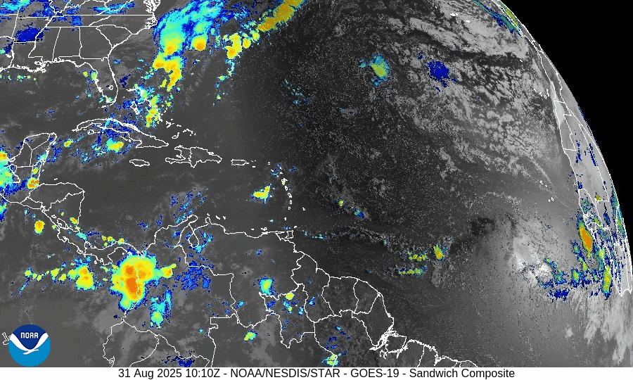
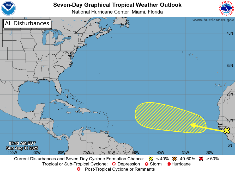
Atlantic Hurricane Outlook – August 31, 2025
On August 31, the Atlantic remains storm-free following the dissipation of Fernand and Erin’s exit. The only feature of interest is a tropical wave moving off Africa, with a low 30% development chance over the next 7 days. Environmental conditions—wind shear, dry air, and Saharan dust—continue to limit storm formation. Florida and the Gulf remain calm aside from typical summer storms.

TLDR Version: Click Here
Atlantic basin remains quiet; a weak wave off Africa shows low (30%) development odds
Atlantic Basin Overview
No Active Storms
There are currently no active tropical cyclones in the Atlantic basin. The calm continues following Fernand’s dissipation and the end of Erin’s impacts.Tropical Wave Near Africa
A tropical wave is forecast to emerge off the west coast of Africa, and the NHC assigns it a low – but not negligible – chance of development: 0% over the next 2 days, increasing to 30% over the next 3 to 7 days.
Environmental Conditions
Sea Surface Temperatures (SSTs): Warm in the Caribbean and Gulf (~29–31 °C), but less favorable conditions in much of the open Atlantic.
Wind Shear: Continues to be elevated across large swaths of the basin, discouraging storm formation.
Mid-Level Humidity & SAL: Dry air and Saharan dust (SAL) remain prevalent, further suppressing convective activity.
Gulf of Mexico & Caribbean
The Gulf remains quiet and stable, dominated by high pressure. Only routine afternoon thunderstorms are occurring along the coasts—no tropical development is expected.
Florida & Southeast U.S. Forecast
Florida continues in its late-August pattern—hot, humid, with scattered afternoon thunderstorms. No tropical threats are present.
Beaches along the Atlantic coast are beginning to calm. With no new swells incoming, rip currents and surf conditions are generally improving, though caution remains prudent in areas still unsettled from earlier systems.
Rain forecast visualization courtesy of Windy.com
Summary

Atlantic basin is currently calm, with no tropical storms or hurricanes active.
A new tropical wave off Africa carries low (30%) development odds over the next week.
Environmental factors (cooler SSTs, shear, dry air, and SAL) continue to limit development potential.
Gulf and Florida remain storm-free, apart from the usual summer thunderstorms.
TL;DR – August 31 Snapshot
The Atlantic is quiet and free of active storms.
A wave off Africa has low (30%) chance of development by next week.
Environmental conditions remain unfavorable for new formations.
Florida and Gulf remain calm with only routine seasonal storms.

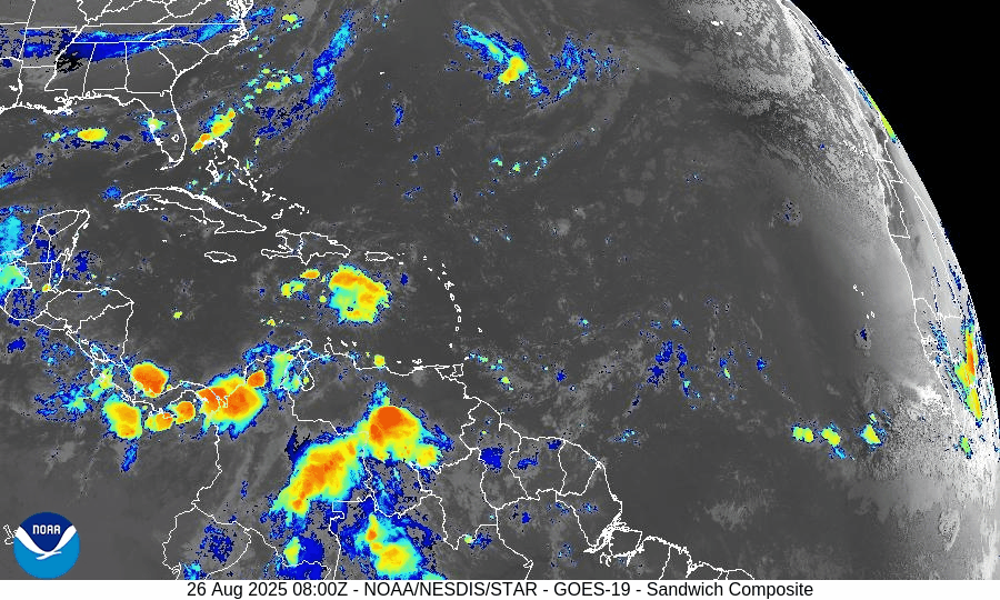
Atlantic Hurricane Outlook – August 26, 2025
On August 26, Tropical Storm Fernand weakened over cooler waters east-northeast of Bermuda and is expected to become post-tropical by Wednesday. While Fernand poses no threat to land, Erin’s swells are still driving dangerous rip currents along the U.S. East Coast. Florida and the Gulf of Mexico remain quiet, experiencing only typical late-August thunderstorms.
TLDR Version: Click Here
Tropical Storm Fernand weakens offshore; Erin’s surf legacy lingers while tropics turn quiet
Atlantic Basin Overview
Tropical Storm Fernand

As of Tuesday morning, Fernand is located about 635 miles east-northeast of Bermuda, moving northeast at ~14 mph with maximum sustained winds near 45 mph and a central pressure of 1005 mb. The storm has weakened over cooler waters and moderate shear, and is forecast to transition into a post-tropical system by Wednesday, dissipating altogether by Thursday. No watches or warnings are in effect, and Fernand poses no threat to land.
Hurricane Erin’s Legacy
Though Erin has been gone for days, its immense size and powerful wave field continue to leave a footprint along the East Coast. Long-period swells and dangerous rip currents remain a hazard from the Carolinas through New England, particularly in areas with open exposure to the Atlantic.
Other Atlantic Activity
The National Hurricane Center reports no active disturbances of concern. A tropical wave that had entered the Caribbean has been choked off by dry air and shear, with 0–10% development odds over the next week
Environmental Conditions
Sea Surface Temperatures (SSTs): The Caribbean and Gulf remain very warm (29–31 °C), supportive of storm formation. In the North Atlantic, Fernand is moving into cooler waters, which will force weakening.
Wind Shear: Shear is moderate over Fernand and forecast to increase, hastening its post-tropical transition. Stronger shear persists across much of the MDR, suppressing new development.
Mid-Level Relative Humidity: Dry mid-level air continues across the central Atlantic, limiting convective organization for any tropical waves.
Saharan Air Layer (SAL): Dust-laden air spans the eastern and central Atlantic, further capping deep convection and hindering tropical development.
Gulf of Mexico & Caribbean
The Gulf remains quiet under high pressure, with no signs of organized development. Only routine afternoon thunderstorms are occurring along coastal regions. Despite very warm waters, the Gulf shows no near-term tropical threats.
Florida & Southeast U.S. Forecast
Florida is under a typical late-August pattern: hot, humid conditions with scattered afternoon thunderstorms driven by sea breezes. Some morning showers are possible along the Gulf Coast.
Along the Atlantic beaches, hazardous surf and rip currents remain the main concern, with energy still propagating from Erin’s remnants and Fernand’s offshore circulation
Rain forecast visualization courtesy of Windy.com

Summary
Fernand has weakened to a 45 mph storm and will become post-tropical by Wednesday.
Erin’s legacy continues to affect the East Coast with dangerous surf and rip currents.
No new Atlantic systems show signs of development; odds remain very low.
Gulf of Mexico and Florida are quiet, with only routine late-summer storms.
Environmental conditions: Warm SSTs but hostile shear, dry air, and SAL are suppressing new activity.
TL;DR – August 26 Snapshot
Fernand weakens offshore; no land impacts expected.
Erin’s swells continue to fuel rip currents along the East Coast.
SAL, dry air, and wind shear are limiting new storm development.
Gulf and Florida remain quiet aside from typical thunderstorms.
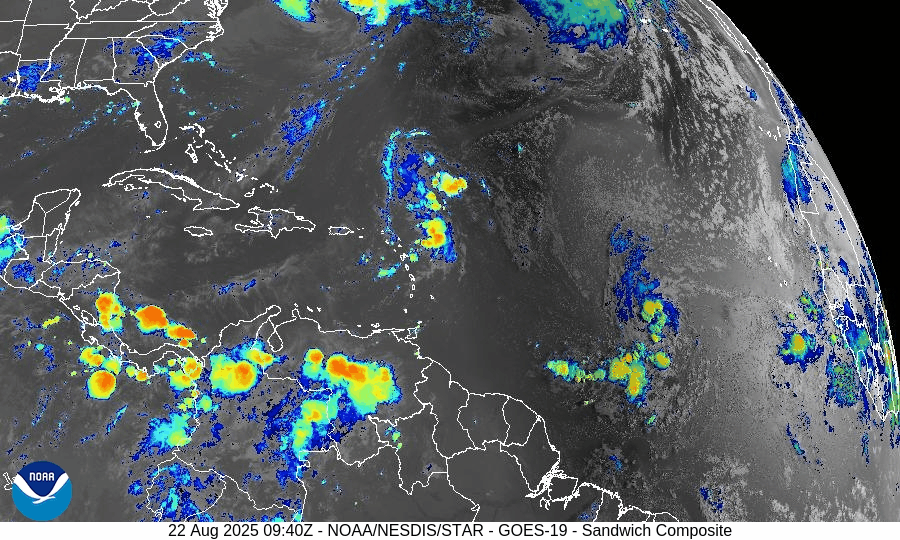
Atlantic Hurricane Outlook – August 22, 2025:Erin weakens; dangerous surf continues along the East Coast
Hurricane Erin dropped to Category 1 on August 22, 2025, as it moved northeast away from the U.S. coast. Despite weakening, the massive storm continues to drive life-threatening rip currents, high surf, and dune erosion from the Carolinas to New England. The Gulf of Mexico and Florida remain calm, with only typical summer thunderstorms.
TLDR Version: Click Here

Atlantic Basin Overview
Hurricane Erin (Category 1)
Erin has weakened to Category 1 with maximum sustained winds near 90 mph and a central pressure of 956 mb. The storm is moving northeast at 22 mph, well away from the U.S. coastline. Erin is a very large cyclone, with tropical-storm-force winds extending over 350 miles from the center.
Although it is transitioning into a post-tropical system, Erin continues to generate life-threatening surf and rip currents along the East Coast. Coastal flooding and dune overwash were reported on North Carolina’s Outer Banks, including sections of NC-12, but major structural damage has been avoided.Coastal and Marine Impacts
“Life-threatening” rip currents and 10–17 ft seas continue from the Carolinas through New England. Numerous beach rescues have been reported this week, with no-swim advisories in place at several popular beaches such as Wrightsville Beach, NC. Conditions will remain hazardous for swimmers and boaters through the weekend as swells spread north into the Canadian Maritimes.Declining Land Warnings
All U.S. coastal tropical storm warnings have been lifted, and advisories for Bermuda were dropped Thursday. Erin will continue weakening as it accelerates northeast, becoming post-tropical by tonight.Additional Atlantic Disturbances
Disturbance east of the Leeward Islands (90L): Highly likely to develop as it tracks northwest and then north between the Lesser Antilles and Bermuda. Formation chances: 70% (48 hr) / 80% (7 day).
Central Atlantic Wave (Invest 99L): Located ~1000 mi WSW of the Cabo Verde Islands. May briefly become a depression before moving into a less favorable environment. Formation chances: 50% (48 hr) / 60% (7 day).
Subtropical Atlantic Low: A small low southwest of the Azores is in a hostile environment and unlikely to develop. Formation chance: 10% (48 hr / 7 day).
90L Invest


99L Invest


Gulf of Mexico & Caribbean
Quiet across the Gulf
The Gulf remains calm, with high pressure suppressing development. Typical afternoon thunderstorms continue along the northern and western Gulf coasts, but no tropical systems are expected over the next 5 days.
Sea-surface temperatures remain very warm (29–31°C), keeping the region primed for potential activity later in the season.
Florida & Southeast U.S. Forecast
Florida Peninsula
Hot and humid conditions persist. Highs near 90–92°F with scattered afternoon and evening thunderstorms driven by sea breezes. No tropical threats are present.Atlantic Beaches (Carolinas to New England)
Even as Erin pulls away, long-period swells will continue to generate high rip-current risks and elevated surf into the weekend. Local advisories remain in effect, and caution is strongly advised for swimmers and small craft.
Rain forecast visualization courtesy of Windy.com
Summary

Erin has weakened to Category 1 and is transitioning to post-tropical as it moves away from the U.S. East Coast.
Primary hazards remain marine: dangerous surf, rip currents, and dune erosion—not landfall.
Outer Banks experienced flooding and road closures, but no widespread structural damage.
Gulf of Mexico is quiet, with no development expected.
Florida remains hot and stormy with only routine summer convection.
Two Atlantic disturbances (AL90 and AL99) have moderate-to-high chances of development in the coming days.
TL;DR – August 22 Snapshot
Erin is now a Category 1, pulling away but still producing hazardous surf and rip currents.
East Coast beaches remain under no-swim advisories due to rip currents and high surf.
The Gulf of Mexico and Florida stay quiet with only routine thunderstorms.
AL90 near the Leewards (70–80%) and AL99 in the central Atlantic (50–60%) are both being monitored for tropical development.