
Atlantic Hurricane Outlook – August 19, 2025: Hurricane Erin holds as a powerful Category 3
Hurricane Erin remains a powerful Category 3 offshore system, bringing life-threatening surf, rip currents, and coastal flooding to the East Coast. Meanwhile, the Gulf of Mexico and Florida stay calm with no new tropical threats expected.
TLDR Version: Click Here

Hurricane Erin holds as a powerful Category 3; Life-threatening surf and flooding are poised to impact the East Coast
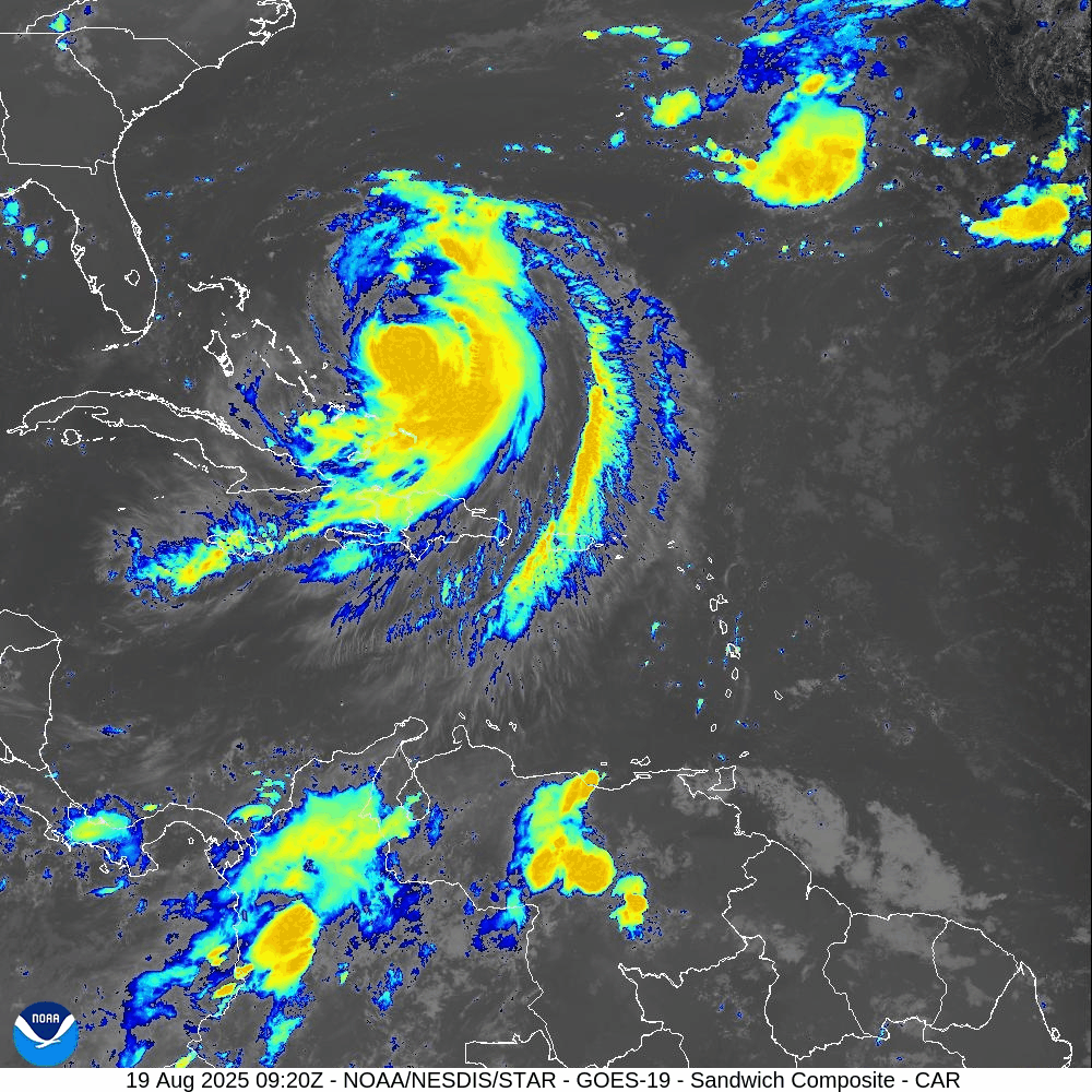
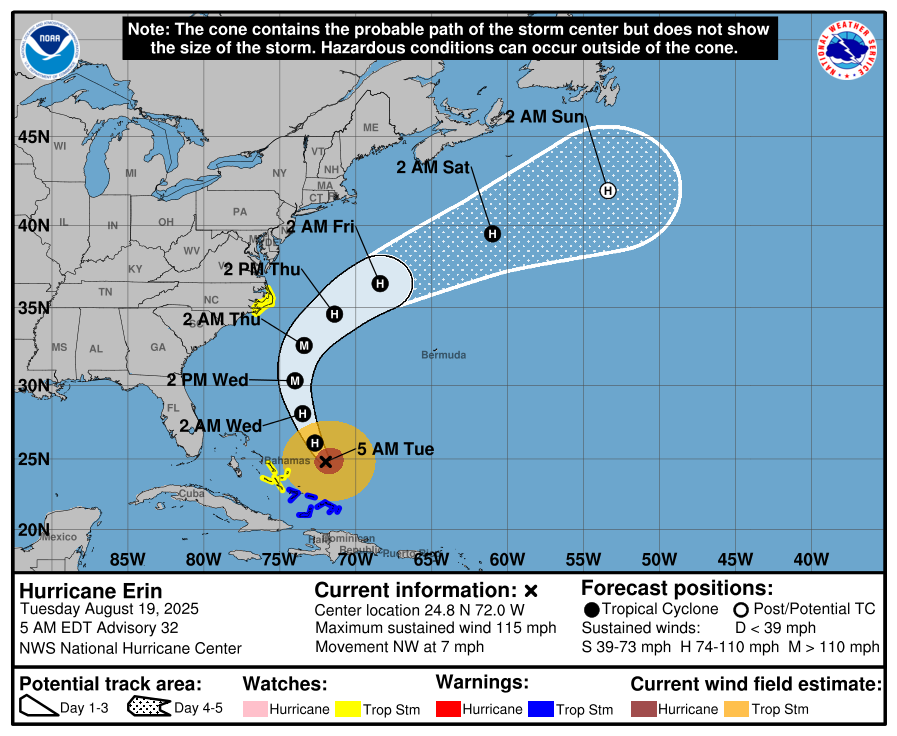
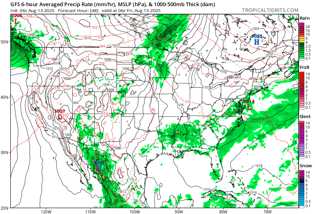
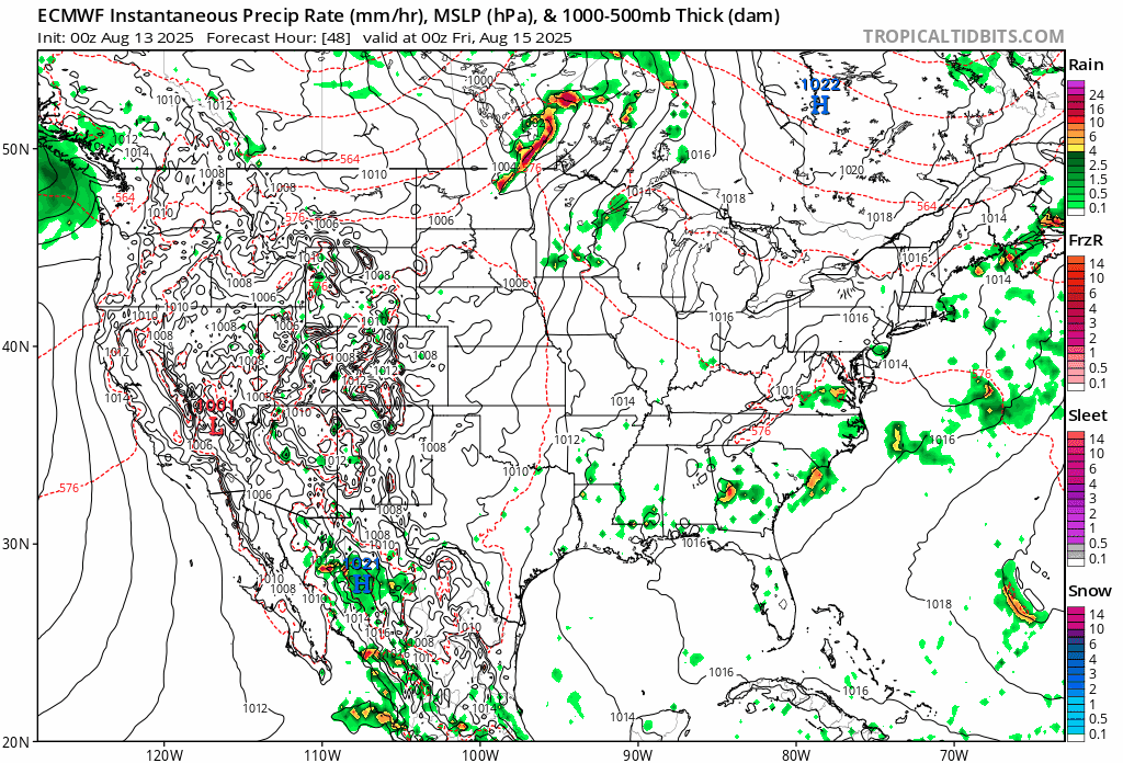
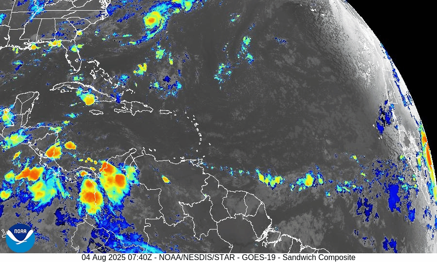
Hurricane Erin, now a Category 3 system with sustained winds near 115 mph, continues its path just east of the Bahamas. While a U.S. landfall remains unlikely, significant coastal impacts are unfolding. Meanwhile, the Gulf of Mexico and Florida remain calm.
Atlantic Basin Overview
Hurricane Erin (Cat 3): Sustained winds are approximately 115 mph. The storm remains offshore, shifted slightly northwest, and continues to drive dangerous surf and rip currents from Florida through New England. Forecasters warn of coastal flooding, storm surge, and beach erosion—especially across the Outer Banks, where evacuation orders are in effect. Waves are expected to reach 15–25 feet, with minor to moderate flooding along the Mid-Atlantic coast. Erin feels the effects of a prior eyewall replacement cycle and is now in a weakening trend influenced by increased shear and dry air.
Other Atlantic systems: No immediate new tropical cyclones are expected. The National Hurricane Center continues to monitor waves and disturbances, but environmental conditions (dry air, wind shear) remain inhibiting.


Gulf of America (Mexico)
Quiet and stable: There are no organized systems. Activity is limited to isolated afternoon convection along the Gulf Coast, tied to heat-driven storm patterns rather than tropical development.
Florida & Southeast U.S. Outlook
Florida Peninsula: Expect routine summertime weather—afternoon thunderstorms fueled by sea breezes. No tropical threats are anticipated.
East Coast (NC to FL): Erin's long-period swells are arriving along coastal areas, raising rip current and surf hazards significantly. Beachgoers must exercise caution, and lifeguard advisories should be strictly followed.
Rain forecast visualization courtesy of Windy.com
Environmental Conditions
Sea Surface Temperatures (SSTs): Remain warm—aiding Erin’s sustained intensity and surf generation.
Wind Shear & Moisture: Increasing shear and dry air are contributing to Erin’s gradual weakening and restraining new development elsewhere in the basin.

TL;DR – August 19 Snapshot
Erin downgraded to Category 3; offshore path continues; U.S. threats are limited to surf, rip currents, and coastal flooding.
Outer Banks under evacuation orders due to expected flooding and beach erosion.
Florida and Gulf: Calm, with routine afternoon storms and no new tropical systems.
Stay alert on the coasts: Dangerous marine conditions ahead—especially from North Carolina to Florida.
Atlantic Hurricane Outlook – August 17, 2025: Erin Got Big
Hurricane Erin briefly reached Category 5 strength but has since weakened to a Category 4 in the Atlantic. While multiple tropical waves remain active, dry air and wind shear are keeping them disorganized. The Gulf of Mexico sees lingering rain, and Florida continues with typical summer storms.
TLDR Version; Click Here
Current Status: Active major hurricane in the Atlantic
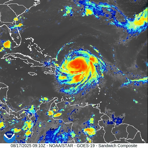
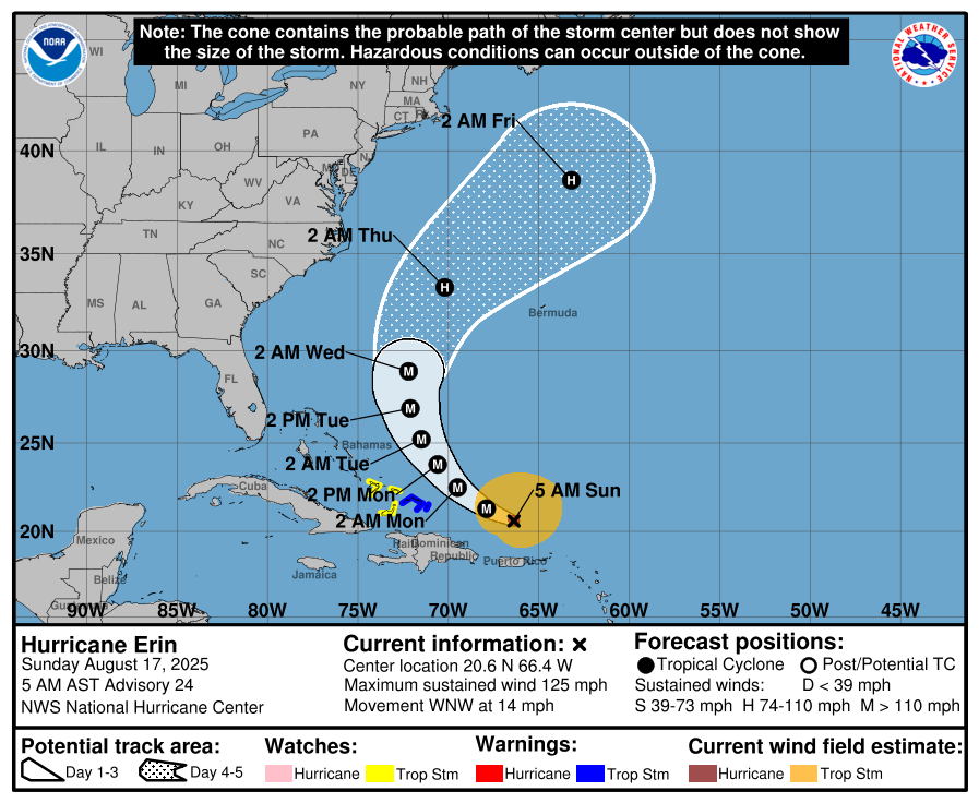
Hurricane Erin (Category 3, formerly Cat 5 then 4)
As of this morning, Hurricane Erin is holding as a Category 3 hurricane with maximum sustained winds near 125mph, after briefly reaching Category 5 intensity yesterday with peak winds of 160 mph.
Erin underwent rapid intensification in the open Atlantic but has since begun a gradual weakening trend due to slight increases in wind shear and internal structural changes (eyewall replacement cycle).
The storm remains over open water and poses no immediate land threat, but it continues to serve as a reminder of how quickly systems can ramp up when environmental conditions align.


Central & Eastern Atlantic
Multiple tropical waves continue to traverse the Main Development Region (MDR).
A wave near 35–40°W remains disorganized with only scattered convection.
Another wave just off Africa near 20–25°W is embedded in the monsoon trough, but Saharan Air Layer (SAL) dust and dry air should keep development limited in the short term.
Gulf of Mexico
Broad moisture and unsettled weather persists across the central and western Gulf.
No organized tropical system is expected, but localized heavy rain and thunderstorms may impact coastal Texas and Louisiana.
Upper-level conditions are not conducive for development at this time.
Florida & Southeast U.S.
Typical afternoon thunderstorms continue across the Florida peninsula, fueled by Gulf moisture and sea-breeze interactions.
No tropical threats are expected for the state today.
Rain forecast visualization courtesy of Windy.com
Key Environmental Factors
Sea Surface Temperatures (SSTs): 29–31 °C across the Gulf and Caribbean, with the MDR slightly above average — plenty of available fuel.
Wind Shear: Increasing in the western Atlantic, contributing to Erin’s weakening and suppressing MDR organization.
Moisture: Pockets of dry air and Saharan dust continue to limit development in the eastern Atlantic.
TL;DR

Hurricane Erin: Now a Category 3, after peaking at Cat 5 yesterday; remains over open Atlantic, no land threat.
Atlantic Tropics: Several waves, but limited organization due to dry air and shear.
Gulf of Mexico: Moisture lingers, rain possible, but no tropical development.
Florida: Routine summer storms, no tropical system expected.
CAT5Prep.com is staying on top of the storms. While Hurricane Erin may have passed the point of direct threat for many, there is more movement in the MDR (Main Development Region) of the Atlantic, and we all need to stay on our toes. The MDR is a critical area for tropical cyclone formation, and activity there often sets the tone for the rest of the hurricane season.
Atlantic Hurricane Outlook – August 13, 2025: Erin Expected to Become 2025’s First Major Hurricane; U.S. Coast Still Unthreatened
Tropical Storm Erin is gaining strength in the Atlantic and could reach major hurricane status this weekend. Forecasts keep it well offshore, but the Southeast coast will see increasing surf and rip currents. Gulf and Florida remain quiet.
A couple disturbances being monitored along with TS Erin
TLDR Version: Click Here
Tropical Storm Erin is continuing its westward progression across the eastern Atlantic, with strong model agreement that it will likely intensify into a major hurricane this weekend. While its path remains well east of the U.S., coastal regions should prepare for elevated surf and rip current risks in the coming days.
Atlantic Basin Overview
Tropical Storm Erin remains steady with sustained winds of 45 mph, moving west at 20 mph.
Forecasts now indicate Erin may become a Category 3 hurricane by Sunday, as environmental conditions improve.
Some models suggest Erin will pass north of the northern Leeward Islands, with a likely northwest turn before reaching the Bahamas—thereby minimizing direct U.S. impacts.
Meanwhile, Invest 96L and other tropical waves remain under observation, but Erin is the dominant system for now.


Gulf of America (Mexico) & Caribbean Conditions
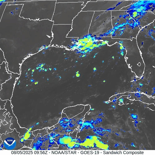
Gulf of America (Mexico): Calm and quiet. Sea surface temperatures are approximately 2°F above average, creating favorable conditions—but without current disturbances.
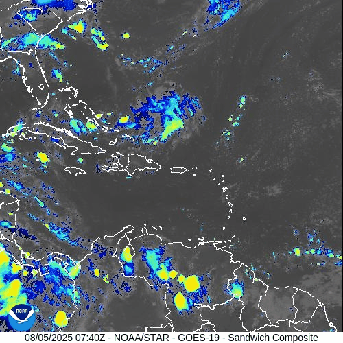
Caribbean Sea: Trade winds and typical convection dominate. No organized systems at this time.
GOES - GULF - Sandwich - August 13, 2025
GOES - Caribbean - Sandwich - August 13, 2025
Florida & Southeast Outlook
Forecast: Expect hot, humid conditions with typical afternoon sea-breeze thunderstorms. These are non-tropical and not linked to Erin.
Marine Hazards: Elevated surf and dangerous rip currents are becoming a concern along the Southeast coast due to Erin’s offshore activity.
Rain forecast visualization courtesy of Windy.com
Looking Ahead & Preparation
Erin is on track to intensify significantly but should remain well offshore through the weekend.
Continue watching Invest 96L and subsequent waves for potential tropical development.
Residents along the Southeast coast should prepare for marine hazards—not wind or rain threats at this stage.
TL;DR – August 13 Snapshot
Erin is strengthening—expected to become 2025’s first major hurricane.
Forecast track keeps it east of the U.S. mainland.
Gulf and Florida remain calm, with routine summer weather.
Watch for increasing surf and rip current hazards along the Eastern Seaboard.
Stay informed with daily updates on Cat5Prep.

Atlantic Hurricane Outlook – August 12, 2025: Tropical Storm Erin Strengthens; Gulf & Florida Remain Calm
Tropical Storm Erin strengthens in the eastern Atlantic with hurricane potential, while the Gulf of Mexico and Florida remain calm. Here’s today’s August 12, 2025 hurricane update.
TLDR Version; Click Here
Tropical Storm Erin, the fifth named storm of the 2025 season, has formed and is steadily intensifying in the eastern Atlantic. No tropical systems are currently threatening U.S. coastlines, but the atmosphere is becoming more favorable for additional activity later in the week.
Atlantic Basin Summary
Tropical Storm Erin is centered roughly 560 miles west-northwest of the Cabo Verde Islands, moving west at 22 mph with sustained winds near 45 mph. Models suggest Erin could strengthen into a hurricane within the next few days and potentially become the season’s first major hurricane. Forecasters anticipate a gradual curve to the northwest later in the week, keeping land impacts unlikely for now.
While Erin organizes, no other significant systems are expected to develop across the Atlantic this week, though other waves are being monitored as conditions continue to evolve.
GEPS Track Model for TS Erin August 12, 2025
GEFS Track Model for TS Erin August 12, 2025
Gulf of America (Mexico) & Caribbean Conditions
Gulf of America (Mexico): Stable weather with no tropical threats. Sea surface temperatures remain elevated—around 2°F above average in early August —but without supportive atmospheric dynamics for development.
Caribbean Sea: General trade wind flow continues, with only typical convective activity. No organized disturbances are present.
GOES - GULF Sandwich August 12, 2025
GOES - Caribbean Sandwich August 12, 2025
Florida Outlook
Forecast for Today: Expect typical mid-August weather—hot, humid, and afternoons marked with scattered sea-breeze thunderstorms that are inland-driven, not tropical. No storm threats are forecasted for the Sunshine State today.
Rain forecast visualization courtesy of Windy.com
Outlook Summary & Preparation
Erin is likely to become a hurricane, but initial tracks keep it far from U.S. landmasses.
Conditions across other tropical basins are quiet but trending toward increased activity as the season progresses.
Watch and prepare calm: Summer heat and moisture supply are ample—ensuring your supplies and plans are ready strengthens resilience.
TL;DR – August 12 Snapshot
Tropical Storm Erin forming and intensifying; likely to become hurricane/maybe a major one.
No U.S. impacts expected in the near term.
Gulf and Florida calm—just routine summer storms.
Season building toward higher activity later this week.
Stay vigilant and stay updated with Cat5Prep.

Atlantic Hurricane Outlook – August 5, 2025: Dexter Weakening, Two Other Areas Monitored
Tropical Storm Dexter weakens far from land, while two other systems—one off Africa and one near the Southeast U.S.—are being watched. Although development chances remain modest, conditions are expected to become more favorable later this month.
Tropical Storm Dexter is slowly weakening but not yet dissipated, while two additional disturbances now carry up to a 30–50% chance of development within the next week. Environmental conditions remain a limiting factor for most areas, but shift slowly toward greater activity as August progresses.
Atlantic Basin Summary
Tropical Storm Dexter
Located roughly 250–275 miles north-northwest of Bermuda, Dexter has maximum sustained winds near 45 mph and is moving northeast at ~12–15 mph. While it is weakening, it may reintensify as a post-tropical cyclone late this week, posing no direct land threat.
Other Areas Under Watch
A low-pressure area offshore of the Southeast U.S. (Invest AL95) carries a 30% chance of development over 7 days. Slight organization is possible as it moves eastward, but land impacts are unlikely.
A tropical wave near ~30°W off Africa shows scattered convection and is assigned a 50% chance of development within 7 days, reflecting improving model support.
Key Environmental Conditions
*In the upper right corner of the below screens, toggle with the +/- icons
Sea Surface Temperatures (SSTs):
Gulf of Mexico, Caribbean, and MDR waters range between 29–31 °C (84–88 °F)—ample heat energy for storm formation if atmospheric conditions cooperate.Wind Shear:
Wind shear remains moderate to high across much of the Atlantic, especially in the central basin, limiting storm organization despite occasional lower-shear pockets emerging near the western Gulf.Saharan Air Layer (SAL):
A large SAL plume continues across the eastern and central Atlantic. Its dry, dusty air suppresses convection and hampers the vertical growth of tropical disturbances.Moisture:
While mid-level humidity is increasing over the western tropical Atlantic, SAL and shear are keeping much of the central MDR too dry for sustained thunderstorm development.
Gulf of America (Mexico) & Caribbean Overview
No disturbances are currently being monitored.
A stationary front and ridge of high pressure maintain light to moderate winds and calm seas across the Gulf and Caribbean.
Scattered showers remain typical for early August and are not linked to tropical systems.
GOES-19 - Sector view: Gulf
GOES-19 - Sector view: Caribbean
Florida Forecast
Highs: Near 90 °F with high humidity.
Afternoon thunderstorms: 40–50% chance from sea breeze activity.
Winds: Light and variable inland, shifting southeast near the coast.
No tropical storm impacts are expected today.
Rain forecast visualization courtesy of Windy.com
Prep Tip of the Day
Make sure your alert systems are working and up-to-date: test county-level emergency alerts, NOAA weather radios, and storm tracking apps. Confirm evacuation plans with household members and review where supplies are stored.
Outlook
Dexter poses no threat to land, but the tropical wave near Africa and Invest off the U.S. Southeast coast warrant close attention. August is historically when activity ramps up; conditions may become more favorable later in the week.
TL;DR – August 5 Snapshot
Tropical Storm Dexter weakening, drifting north but may reintensify offshore.
Two areas monitored: AL95 (30% chance) and African wave (~50% chance) for potential development.
SSTs remain warm, but SAL and wind shear continue to suppress many systems.
No tropical threats to Florida today—just typical summer storms.
Expect activity to increase as August progresses.
Stay ready and informed with daily updates at Cat5Prep.com.
Atlantic Hurricane Outlook – August 4, 2025: Tropical Storm Dexter Forms; Two Other Systems Under Watch
Tropical Storm Dexter forms off the East Coast with no land threat. Meanwhile, a tropical wave off Africa and a low near the Southeast U.S. are being monitored as conditions slowly shift toward a more active period.
*Those who like data, continue reading. Those it prefer the quick version, jump to the TL;DR here.
Tropical Storm Dexter has developed in the western Atlantic, while two additional systems are being monitored for potential development. Conditions across the basin remain dynamic—with storm formation possible in coming days.
Atlantic Basin Summary
Tropical Storm Dexter: The fourth named storm of the 2025 season formed late Sunday night, now located ~255 miles northwest of Bermuda. Maximum sustained winds are 45 mph, and the system is moving east-northeast. It’s expected to remain over open water and become post-tropical by Wednesday with no threat to U.S. land.
Disturbance AL95: A non-tropical low pressure area off the Southeast U.S. coast is being monitored with medium (30%) development chance over 7 days. Movement is east-northeast under weak shear, and formation may remain offshore.
New tropical wave emerging off Africa (~30°W): Forecast to track westward with scattered convection. The formation chance is 50% over 7 days, indicating growing potential for a tropical depression if favorable conditions develop.
Environmental Conditions
Sea Surface Temperatures (SSTs):
Waters in the Gulf of Mexico, Caribbean, and MDR remain warm at 29–31°C (84–88°F)—providing ample energy if atmospheric conditions become supportive.Wind Shear:
Still moderate to high across much of the Atlantic, limiting vertical storm structure. However, shear may relax in the western basin later this month.Saharan Air Layer (SAL):
Persistent dry, dusty air continues to suppress convection, especially over the eastern and central Atlantic. This remains a major inhibiting factor for newly emerging systems.Moisture:
Improving moisture levels seen in the western Caribbean and Gulf, though much of the basin remains too dry for sustained disturbance development.
Gulf of America (Mexico) & Caribbean Region
No tropical systems currently forming.
A dominant high-pressure ridge promotes generally calm, hot conditions across the Gulf and Caribbean.
Scattered showers remain typical for August, with no organized convection tied to tropical disturbances.
GOES-19 - Sector view: Gulf
GOES-19 - Sector view: Caribbean
Florida Forecast
Highs: Upper 80s to near 90°F under humid conditions.
Afternoon thunderstorms: 40–50% chance, typically from sea breeze convergence—non-tropical in origin.
Winds: Light and variable inland; southeasterly near the coast.
No tropical storm impacts are expected today.
Rain forecast visualization courtesy of Windy.com
Prep Tip of the Day
Stay connected to emerging tropical watches and alerts: sign up for NOAA and county-level emergency notifications, test weather radios, and review your communication plans with family or household members.
Looking Ahead
Though Dexter poses no immediate risk to land, the emerging wave and mid-Atlantic trough (AL95) warrant attention. The signal is clear: early August may mark the beginning of a more active period in the tropical Atlantic.
TL;DR – August 4, 2025 Summary
Tropical Storm Dexter forms off the East Coast—staying far offshore and weakest by midweek.
Low pressure (AL95) offshore Southeast U.S. with 30% development chance.
New wave off Africa (~30°W) entering the Atlantic—50% chance of development in 7 days.
SSTs supportive but SAL and shear remain inhibitory.
No threat to Florida; typical summer thunderstorms expected.
Atlantic Hurricane Outlook – August 3, 2025: Two Areas Now Under Watch
The Atlantic remains calm with no named storms, but two areas—one off the U.S. coast and another off Africa—are now under watch for potential tropical development. Here's today's scientific hurricane outlook.
*Those who like data, continue reading. Those it prefer the quick version, jump to the TL;DR here.
As early August continues, the Atlantic remains without any active tropical cyclones. However, two areas have emerged as brown disturbance watches, as forecasters monitor subtle signs that could impact the Atlantic if conditions shift.
Atlantic Basin Highlights
No active tropical storms in the basin.
Two areas are now under National Hurricane Center scrutiny:
Invest Area AL95: Expected to be a fish storm, it’s a non-tropical low just off the North Carolina coast—producing disorganized thunderstorms. (The orange X on the chart)
➤ Chance of development: Medium (30%) over the next 2–7 days.
➤ Movement: Toward the east-northeast at ~10 mph, expected to stay offshore.Emerging tropical wave off Africa: Near 30°W, forecast to move westward with scattered convection.
➤ Chance of development: Low (30%) within 7 days.
GOES-19 - Sector view: North Atlantic - Sandwich - August 3, 2025
GOES-19 - Sector view: Tropical Atlantic - Sandwich - August 3, 2025
Key Environmental Conditions
Sea Surface Temperatures (SSTs):
The Gulf of Mexico and Caribbean Sea remain very warm, with temperatures ranging from 29–31°C (84–88°F). The Main Development Region (MDR) is also running slightly above average. These warm waters provide abundant fuel for tropical development — if other atmospheric factors allow.Wind Shear:
Moderate to high vertical wind shear persists across the central Atlantic, particularly along the latitude band where Disturbance 2 is located. This disrupts the vertical alignment of developing systems and limits the ability of convection to consolidate around a center.Moisture:
Mid-level moisture is gradually increasing across the western tropical Atlantic and Caribbean. However, the central Atlantic remains drier overall, especially in areas affected by Saharan dust, limiting deep convection and thunderstorm persistence.Saharan Air Layer (SAL):
A robust SAL is sweeping across the central and eastern Atlantic, characterized by dry, dusty air and suppressed vertical motion. The SAL also contributes to a stable atmosphere, effectively capping thunderstorm development and working against tropical wave organization.
Implication for Disturbance 2:
While ocean temperatures are favorable, the combined influence of high wind shear, limited moisture, and widespread SAL intrusion is expected to stall or inhibit further development of Disturbance 2 as it continues westward across the tropical Atlantic. Until it reaches a more favorable environment, organization remains unlikely.
Gulf of America (Mexico) & Caribbean Region
No disturbances active in the Gulf, and high-pressure conditions support light winds and minimal rain outside normal sea‑breeze showers.
Eastern Caribbean: A wave near 68°W is producing localized storms over Hispaniola and Venezuela but remains disorganized.
GOES-19 - Sector view: Gulf of America - Sandwich - August 3, 2025
GOES-19 - Sector view: Caribbean - Sandwich - August 3, 2025
Florida Weather Outlook
Highs: Near 90 °F under sticky, humid conditions.
Conditions: Scattered afternoon thunderstorms from sea breeze interactions.
No tropical impacts expected today.
Rain forecast visualization courtesy of Windy.com
Prep Tip of the Day: Know Your Warning Signals
Test your alert systems today:
Confirm subscription to NOAA alerts and local county emergency systems.
Test NOAA weather radios and storm tracker apps.
Make sure household members know hurricane communication plans and locations of essential documents.
Outlooking Ahead
Invest Area AL95, while moving away from land, bears watching if it gains tropical characteristics. Meanwhile, the wave off Africa will pass into warmer waters—another early‑August indicator. Meteorological models forecast these systems might strengthen if wind shear declines and dust regresses later this month.
TL;DR – August 3 Hurricane Summary
No storms currently in the Atlantic basin.
AL95 (off North Carolina): 30% chance of development over the next week. (Fish Storm)
African wave near 30°W: 20% chance of development within 7 days.
Factors are currently favoring disorganization.
SSTs are warm and moisture is increasing—conditions may improve in early August.
Immediate risk remains low; now is a good window for storm preparedness.
Stay alert and ready with daily forecasts at Cat5Prep.com.
Atlantic Hurricane Outlook – August 2, 2025: Watching Waves, But No Storms Expected
The Atlantic remains calm to start August, with no storms expected this week. A few tropical waves are being monitored, but dry air and wind shear continue to suppress development—for now.
*Those who like data, continue reading. Those it prefer the quick version, jump to the TL;DR here.
As we settle into early August, the Atlantic remains quiet—no active tropical systems and no development forecasted over the next seven days. Although several tropical waves continue moving westward, persistent upper-level wind shear and Saharan dust limit their potential for organization.
Atlantic Basin Summary
Latest NHC Tropical Weather Scales:
The 8 AM EDT Tropical Weather Outlook confirms no systems expected to form within seven days.
Multiple tropical waves are active:
A wave near 43–50°W with scattered convection.
A new wave moving off Africa near 30°W, gradually tracking westward.
None display organized circulation or development potential at this time.
Satellite imagery provided by Windy.com
Environmental Conditions
Sea Surface Temperatures (SSTs):
29–31 °C (84–88 °F) across the Gulf of Mexico and Caribbean.
MDR temperatures remain slightly above average, offering rising energy for late-season storms.
Wind Shear:
Still moderate to high across much of the basin, inhibiting vertical growth.
Saharan Air Layer (SAL):
Thick dry air layer continues across most of the MDR, suppressing convection and storm development.
Atmospheric Moisture:
Gradually increasing in the western Atlantic and Caribbean—monitoring for signs of improved convective support.
Gulf of America (Mexico) & Caribbean Region
No disturbances currently monitored.
A dominant high-pressure ridge maintains light winds and calm seas.
Scattered showers along Florida’s west coast remain typical summer moisture—not tropical in origin.
Radar imagery courtesy of Windy.com
Florida Forecast
Highs: Upper 80s to low 90s °F with high humidity.
Rain Chances: 40–50% for scattered afternoon thunderstorms due to seabreeze convergence.
Winds: Light and variable.
No tropical threats expected in Florida today.
Rain forecast visualization courtesy of Windy.com
Seasonal Outlook
The Atlantic season to date includes three named storms (Andrea, Barry, and Chantal), but lacks any hurricanes—a below-average ACE, echoing early-season inactivity last seen in 2009.
NOAA and CSU continue to forecast above-average hurricane activity overall, with 13–19 named storms and 6–10 hurricanes anticipated this season.
August typically marks the ramp-up of tropical activity, especially across the MDR and Gulf of Mexico, where conditions may become more favorable by mid-month.
Prep Tip of the Day: Verify Your Alert Setup
Now is a good time to:
Confirm you’re registered with local emergency alert systems.
Test NOAA weather radios and app notifications.
Re-check family communication plans and emergency kit locations.
Looking Ahead
While the forecast remains calm now, early August often brings the first major shifts in seasonal activity. Keep tracking tropical waves as they approach warmer waters and potentially lower shear environments.
TL;DR – August 2, 2025 Hurricane Summary
No active storms or developing systems in the Atlantic.
Several tropical waves are present but remain weak and disorganized.
High wind shear and Saharan dust continue to suppress development.
Sea surface temperatures are high and rising.
Historical patterns suggest increased activity may begin in mid‑August.
Stay prepared and stay informed with daily updates from Cat5Prep.com.

Atlantic Hurricane Outlook – July 16, 2025: Gulf Disturbance Lingers, Tropics Stay Quiet
A weak low in the Gulf of Mexico brings rain and storms to Florida, but no tropical development is expected. Cat5Prep’s daily update covers real-time conditions, SSTs, and what to watch next.
The Atlantic hurricane basin remains quiet in terms of named storms, but attention continues to center on a weak low-pressure system lingering over the eastern Gulf of Mexico. Although this system remains disorganized and development chances are low, it’s bringing widespread showers and thunderstorms across parts of Florida, the northeastern Gulf, and coastal Georgia.
While no tropical development is expected over the next 7 days, the broader environment is slowly shifting toward favorability, with rising sea surface temperatures, weakening wind shear, and the gradual retreat of the Saharan Air Layer (SAL).
Atlantic Basin Overview
As of the latest NHC update (2:00 PM EDT):
No active tropical cyclones
One disturbance in the Gulf of Mexico (Low development chance)
No tropical formation expected in the next 7 days
Satellite imagery courtesy of Windy.com
Disturbance in the Gulf of Mexico
A broad area of low pressure continues to meander just west of Florida over the northeastern Gulf of Mexico:
Development chances remain low (0% over 48 hours, 10% over 7 days)
System remains non-tropical and disorganized
Producing periods of heavy rainfall, especially across the Florida Panhandle, southern Georgia, and coastal South Carolina
Some gusty winds and isolated flooding may occur, especially in areas with poor drainage
This system is expected to drift inland by late Thursday, reducing any tropical potential.
Radar imagery courtesy of Windy.com
Sea Surface Temperatures (SSTs)
Ocean temperatures remain exceptionally warm, providing high potential energy for storm development once other conditions align:
Gulf of Mexico: 86–89°F (2–4°F above normal)
Western Caribbean: 85–88°F
Main Development Region (MDR): Now reaching 82–84°F across much of the eastern Atlantic
Sea Surface Temperature data courtesy of Windy.com
Atmospheric Conditions
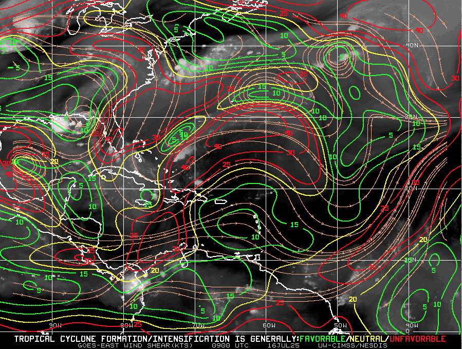
Wind Shear Courtesy of https://tropic.ssec.wisc.edu/
Wind Shear: Still elevated in the western Atlantic and Gulf, but beginning to weaken, particularly near Central America and the western Caribbean.
Moisture: Mid-level moisture continues to increase, especially in the Caribbean and southern Gulf.
Saharan Air Layer: A large, dry SAL continues to stretch across the central Atlantic, suppressing storm formation east of the Lesser Antilles, but it's expected to weaken by early August.
Relative Humidity (ECMWF) data courtesy of Windy.com
Saharan Air Layer (Dust) data courtesy of Windy.com
Thunderstorm & Rainfall Activity
Florida & Gulf Coast: Expect locally heavy rain and thunderstorm clusters tied to the Gulf disturbance.
Western Caribbean: Some disorganized convection continues, but nothing tropical at this time.
West Africa: A new tropical wave has emerged, but faces significant dry air and shear over the central Atlantic.
Rainfall forecast (ECMWF) courtesy of Windy.com
Florida Forecast
Highs: Upper 80s to low 90s°F
Humidity: High, with a heat index reaching the upper 90s
Rain: 60–70% chance of scattered storms in parts of Florida, especially in the afternoon and evening
Winds: Light southeast winds, with occasional gusts during storms
Prep Tip of the Day: Review Flood Insurance Coverage
Standard homeowners insurance does not cover flood damage. Use this calm window to:
Check your flood zone designation
Review your current policy limits
Confirm your coverage start date (flood insurance usually has a 30-day waiting period)
With warm SSTs and an increasingly favorable atmosphere, inland and coastal flood risk rises as we move deeper into hurricane season.
Looking Ahead: Watchful, Not Worrying
Although July 16 brings no immediate storm threats, all eyes remain on the broader Atlantic:
The ingredients for development are aligning: warm water, weakening shear, and increased moisture.
The next two weeks may see the first organized systems forming in the western Caribbean or Gulf of Mexico.
Now is the time to stay informed and finalize preparations—not when a storm is already on the map.

Atlantic Hurricane Outlook – July 15, 2025: Gulf System Organizing, Tropics on Alert
A weak low over Florida is drifting into the Gulf of Mexico, producing heavy rain and prompting close monitoring. While development chances remain low, record-warm waters and shifting winds suggest more activity is coming.
The Atlantic remains officially quiet, but eyes are turning toward the Gulf of Mexico as a broad area of low pressure continues to develop. Though not yet a tropical depression, this system is producing heavy rainfall across parts of Florida and may slowly organize over the next few days. Elsewhere, warm sea surface temperatures and improving atmospheric conditions continue to set the stage for increased activity as July progresses.
Atlantic Basin: Watching the Gulf
As of this morning’s update from the National Hurricane Center (NHC):
No named tropical cyclones
One area of interest: Disturbance near Florida
Development potential: Low over 48 hours (10%), Slightly higher over 7 days (20%)
A broad, weak surface trough stretching across southern Florida is generating scattered storms and heavy rainfall. As it drifts westward into the Gulf of Mexico, slight development is possible—though wind shear and dry air may continue to limit its growth in the near term.
Regardless of tropical classification, this system is expected to bring:
Heavy rainfall across Florida and the Gulf Coast
Localized flash flooding
Coastal thunderstorms and rough surf
Satellite imagery courtesy of Windy.com
Sea Surface Temperatures: Primed and Warming
Waters across much of the Atlantic basin are running well above average:
Gulf of Mexico: 87–89°F (30–32°C) across much of the basin—ideal for storm formation
Caribbean Sea: Persistently warm, with temperatures near or above 86°F (30°C)
Main Development Region (MDR): Trending well above average for mid-July
This level of ocean heat content supports rapid intensification potential for any system that organizes in the coming weeks.
Sea Surface Temperature (ECMWF Analysis) courtesy of Windy.com
Atmospheric Conditions: Becoming More Favorable

Wind Shear Courtesy of https://tropic.ssec.wisc.edu/
Wind Shear: Moderate across the Gulf and Caribbean, but forecast models show a gradual easing through late week
Moisture Levels: Improving, especially in the western Caribbean and southern Gulf
Upper-Level Winds: Starting to show a less hostile pattern over the Gulf and MDR
Overall, the atmospheric profile is trending toward neutral to favorable—a subtle but important change.
Relative Humidity data (ECMWF) courtesy of Windy.com
Saharan Air Layer (SAL): Retreating Slowly
Dry air remains across parts of the eastern Atlantic but is beginning to loosen its grip:
Still suppressing deep convection off the African coast
Expected to retreat westward and weaken through the next 7–10 days
This transition opens the door for tropical waves to survive and organize
Saharan Air Layer (Dust) data courtesy of Windy.com
Florida & Gulf Coast Forecast: Wet and Stormy
The disturbance currently over Florida is impacting much of the region:
Florida Peninsula
Scattered to widespread showers and storms today
Localized flooding possible, especially in urban areas
Highs in the upper 80s to low 90s°F
Northern Gulf Coast (AL/MS/FL Panhandle)
Cloudier skies and increasing storms through tomorrow
Elevated rainfall totals possible
Winds 10–20 mph with gusty thunderstorms
Radar imagery courtesy of Windy.com
Prep Tip of the Day: Secure Outdoor Items
With storms increasing across the Southeast:
Bring in or secure loose outdoor items like patio furniture, garden tools, and trash bins
Clear storm drains and gutters to reduce urban flooding risk
Monitor flash flood alerts in flood-prone neighborhoods
Looking Ahead: A Pattern Shift Is Coming
Although no named systems are expected in the next few days, the Gulf disturbance is a reminder that even weak systems can cause significant impacts. Sea surface temperatures and weakening wind shear are setting the table for development in the latter half of July.
Stay tuned, stay prepared, and check back daily with Cat5Prep for accurate, actionable updates.