
Atlantic Hurricane Outlook – July 9, 2025: Calm Seas Persist Amid Seasonal Build
The Atlantic remains quiet today, with no active storms and no development expected. But record-warm waters and shifting atmospheric patterns suggest that tropical activity could ramp up soon.
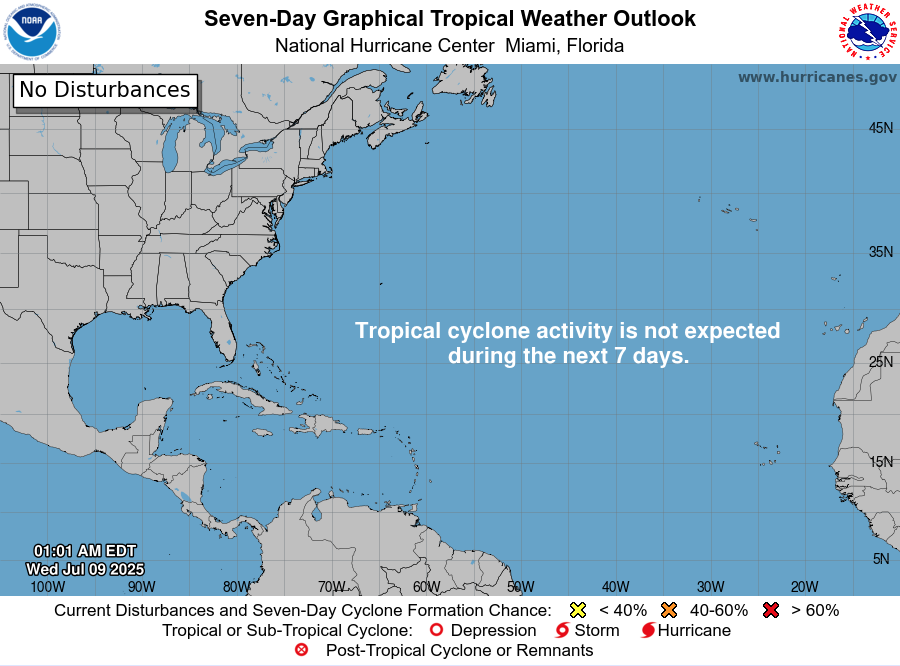
Mid-July typically signals more tropical activity—but today, the Atlantic remains unusually quiet. According to the latest NHC updates, no tropical cyclones are present, with no expected development over the next seven days. Despite the current calm, strong indicators suggest the season’s intensity is primed to rise.
Atlantic Basin: All Clear for Now
No active systems in the Atlantic, Caribbean, or Gulf
NHC forecast maintains zero development chances across the basin
This lull is rare for July and may end soon as heat and moisture build
Satellite view via Windy.com
Seasonal Outlook: Above-Normal Conditions Ahead
CSU’s July update continues to forecast an above-average season:
~17 named storms, including ~9 hurricanes and ~4 major hurricanes .NOAA similarly predicts 13–19 named storms, with a 60% chance of a busier-than-average season.
Sea Surface Temperatures: High Heat Levels
Atlantic SSTs remain well above normal—2–4°F above average—in the Gulf, Caribbean, and MDR
These elevated temperatures continue to provide plenty of energy for storm formation in the weeks ahead
Sea Surface Temperature via Windy.com
Atmospheric Conditions: Secondary Barriers Easing

Wind Shear Courtesy of https://tropic.ssec.wisc.edu/
Wind shear remains moderate-to-high, particularly in the eastern Atlantic—temporarily limiting development
Saharan Air Layer (SAL) and occasional dry mid-level air still suppress convection but are expected to diminish
Moisture is steadily increasing, with abundant humidity projected across storm-prone regions
Saharan Air Layer (Dust) via Windy.com
What to Watch Next
Upcoming Infrared and visible satellite loops for signs of organization
Shifts in wind shear over the Gulf and Caribbean
Any African easterly waves gaining moisture and structure
Wind Gust Accumulation Forecast (ECMWF) via Windy.com
Early July Trends
Only one named storm (Chantal) has formed so far, but it remained weak and quickly dissipated
History shows many July systems originate in the Gulf, Caribbean, or off the Southeast U.S. coast
Outlook: Active Patterns Brewing
While quiet now, the combination of warm SSTs, moist air, and weakening shear/SAL signals a rising likelihood of Atlantic development
Hurricane Season Peak is still ahead—August through October—but increased vigilance is essential now
Prep Tip of the Day: Check Your Alert Systems
With the season expected to intensify:
Confirm NOAA Weather Radio is operational
Enable emergency alerts on all devices
Update your hurricane kit and evacuation plan
Bookmark Cat5Prep.com and the National Hurricane Center for future updates
The Atlantic remains calm—but the foundation for tropical activity is strengthening daily. Stay alert, stay prepared, and check back tomorrow for your next Cat5Prep.com outlook.

Atlantic Hurricane Outlook – June 12, 2025: Dusty Skies, Quiet Tropics
The Atlantic basin remains quiet with no tropical activity expected over the next week. Strong Saharan dust suppresses storm development and reduces air quality across Florida, but warming waters and easing wind shear hint at increased hurricane potential later in June.
As we move through the second week of the Atlantic hurricane season, the basin remains quiet. There are no active tropical cyclones, no areas of interest, and no expected development over the next 7 days, according to the National Hurricane Center’s 2 AM EDT outlook. While this calm is typical for early June, forecasters are keeping an eye on evolving conditions that could shift toward tropical development later this month.
Atlantic Basin: Still and Stable
No tropical systems are on the map, and the 7-day outlook remains clear. The Atlantic basin continues its quiet streak, consistent with climatology for early June. However, this calm will not last forever, and underlying signals suggest more favorable conditions could emerge by late June or early July.
Satellite image courtesy of Windy.com
Sea Surface Temperatures: Warm and Ready
Ocean waters across the Atlantic basin are trending warm, offering potential fuel for future storms.
Gulf of America (Mexico): Low to mid-80s°F (28–30°C), above average in many spots.
Western Caribbean: Warm and supportive of tropical development later in the season.
Main Development Region (MDR): Warmer than normal for this time of year, laying the groundwork for long-track systems from Africa.
Sea surface temperature data courtesy of Windy.com
Atmospheric Conditions: Slowly Trending Toward Favorable
While the Atlantic remains quiet, the atmosphere is showing signs of gradual change.
Wind Shear remains moderate to high across parts of the Caribbean and central Atlantic, still limiting storm formation. However, global models suggest a slow reduction in shear over the coming weeks.
Mid-level moisture is increasing across the Caribbean and Gulf—helpful for deep convection and thunderstorms.
These subtle shifts are typical precursors to an uptick in tropical activity as the season matures.

Wind Shear Courtesy of https://tropic.ssec.wisc.edu/
Saharan Air Layer: Strong and Dusty
A massive plume of Saharan dust is stretching across the Atlantic and reaching Florida and the Gulf Coast today.
The dry air and strong upper-level winds associated with the Saharan Air Layer (SAL) are suppressing tropical development.
This dust layer is also reducing air quality and visibility in parts of Florida and the Southeast, especially for those with respiratory conditions.
The SAL is expected to remain dominant into mid-to-late June before it begins to weaken.
Dust/SAL data courtesy of Windy.com
Thunderstorm Activity: Mostly Local and Non-Tropical
Convective activity across the Atlantic basin is minimal and disorganized.
Florida: Hazy skies and isolated afternoon thunderstorms are expected, but nothing tropical in nature.
Western Caribbean and Off the U.S. East Coast: Scattered showers remain unorganized.
Thunderstorm data courtesy of Windy.com
Florida Forecast: Dusty Skies, Humid Air
Highs: Upper 80s to low 90s°F (31–33°C)
Skies: Hazy due to Saharan dust
Rain Chances: Scattered PM thunderstorms possible
Air Quality: Reduced in some areas—sensitive groups should take precautions
Winds: Light and variable
Rain data courtesy of Windy.com
Prep Tip of the Day: Protect Your Lungs and Finalize Your Plan
Use the quiet to finalize your hurricane prep, especially while dusty skies dominate:
Limit outdoor activity if you’re sensitive to dust or pollen
Replace or clean air filters in your home and car
Check that your family communication plan and evacuation routes are up to date
Store key websites in your browser bookmarks: hurricanes.gov, Cat5Prep.com
Looking Ahead: The Table Is Being Set
While the tropics are calm today, the pieces are slowly moving into place for increased activity later this month. Warm waters, a gradual easing of wind shear, and rising moisture hint at a more active pattern on the horizon. Stay vigilant, and check back daily for updates.

Atlantic Hurricane Outlook – June 11, 2025: Quiet Tropics Continue Amid Rising Possibilities
he Atlantic basin remains calm on June 11, 2025, with no tropical storms or disturbances expected over the next week. However, warming sea surface temperatures and easing atmospheric barriers hint at increased hurricane activity later this month. Stay prepared with daily updates from Cat5Prep.com.
The twelfth day of the 2025 Atlantic hurricane season opens with calm conditions—no tropical storms, depressions, or areas being actively monitored. According to the National Hurricane Center (NHC), no tropical cyclone formation is expected over the next seven days. The basin remains in an early-season lull, but the combined presence of warm water and easing atmospheric barriers demands continued attention.

Atlantic Basin: Clear Today, But Shifts Are Underway
Active Systems: Zero
Disturbances: None
Tropical Formation Outlook: No development expected through June 18, 2025.
This state of inactivity is consistent with early June climatology. Still, meteorologists point out that subtle environmental shifts are in motion beneath the surface.
Satellite imagery courtesy of Windy.com
Sea Surface Temperatures: A Growing Foundation
Gulf of America (Mexico) & Western Caribbean: Steady low- to mid‑80s °F (27–29 °C), ideal for fuel if storms form
Main Development Region (MDR): Sea surface temperatures are trending above normal for early June
These warm waters persist as a critical energy reserve for potential fast-moving tropical systems.
Sea surface temperature data courtesy of Windy.com
Wind Shear & Moisture: Gradual Improvements
Wind Shear: Moderate to high across much of the basin, suppressing storm development
Moisture: Midlevel humidity is slowly climbing in the Gulf and Caribbean—supporting the formation of deeper convection
This evolving balance suggests the atmosphere may be priming for tropical cyclones in the coming weeks.

Wind Shear Courtesy of https://tropic.ssec.wisc.edu/
Saharan Air Layer: A Continuing Deterrent
An active plume of Saharan dust covers the central and eastern Atlantic, suppressing convection and reinforcing vertical wind shear
This protective layer is expected to weaken by late June, enabling better conditions for tropical wave development
Saharan Air Layer (SAL) data courtesy of Windy.com
Thunderstorm Activity: Local, Non-Tropical
Florida & Southeast U.S.: Expect isolated afternoon storms—standard for this time of year
Western Caribbean: A few clusters of showers persist but remain disorganized
Central Atlantic: Remains convection-free with no signs of tropical wave development
Thunderstorm data courtesy of Windy.com
Florida Forecast (Statewide)
Highs: Upper 80s to low 90s °F (31–33 °C)
Humidity: Moderate to high—classic muggy summer conditions
Rain: Scattered midday and afternoon thunderstorms
Winds: Light and steady
Rainfall data courtesy of Windy.com
Prep Tip of the Day: Check NOAA Weather Radio
Take advantage of quiet skies to:
Test your NOAA Weather Radio
Confirm you are signed up for mobile and text alert services
Ensure your emergency gear is functional and accessible
Staying alert now reduces stress later.
Looking Ahead: Remain Alert, Not Alarmed
While no tropical formations are expected through June 18, the convergence of:
Persisting warm SSTs
Weakening wind shear
And waning Saharan dust
set the stage for increased activity during the latter half of June.
Stay connected to Cat5Prep.com for your daily update and tracking as the tropical season progresses.