
Atlantic Hurricane Outlook – July 29, 2025: Active Waves, Quiet Forecast
Several tropical waves are moving across the Atlantic, but none show signs of imminent development. Warm waters persist, and August may bring change.
*Those who like data, continue reading. Those it prefer the quick version, jump to the TL;DR here.
Though the Atlantic basin remains free of tropical cyclones, several tropical waves are shifting across the ocean—each monitored for organization. Conditions remain broadly unfavorable for development, but the warm ocean and evolving atmospheric patterns suggest potential change in the weeks ahead.
Atlantic Basin: No Cyclones, But Several Waves in Motion
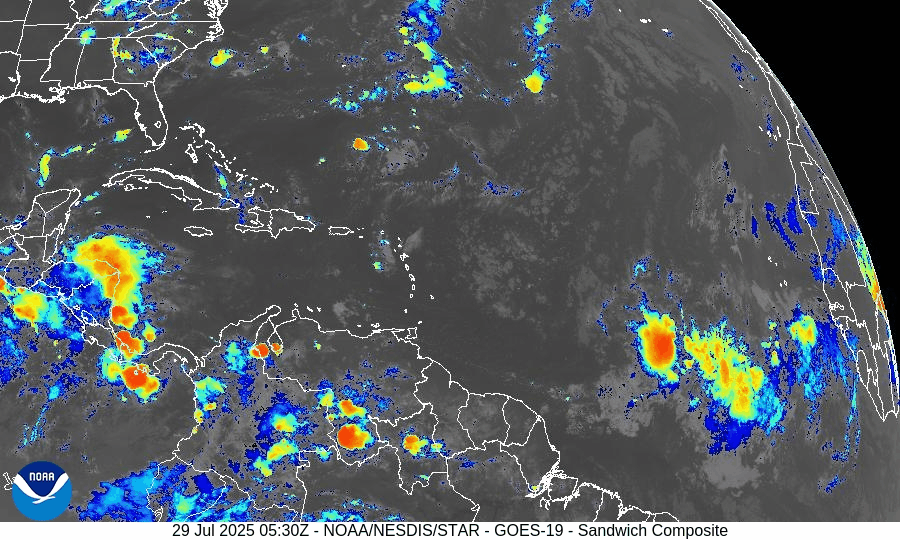
According to the latest Tropical Weather Outlook, the National Hurricane Center does not expect any tropical cyclone formation during the next seven days. However, recent Tropical Weather Discussion reveals:
A tropical wave near 19°W (south of 19°N), moving westward at about 10 kt, with scattered convection between 10°N–13°N and east of 23°W.
Another wave near 38°W, south of 18°N, moving slowly (~5 kt), associated with a 1012 mb low. A scatterometer pass noted fresh to strong winds within 120 nm and scattered convection between 5°N–12°N.
None of these features currently exhibit a closed circulation or organization, but their movement into warmer waters bears monitoring.
Gulf of Mexico & Caribbean: Calm Signals, Minimal Development Risk
No disturbances are being tracked in the Gulf at this time.
Surface analyses and satellite imagery show mostly typical trade-wind patterns and minor convection near Central America and the Windward Passage.
A dominant high-pressure ridge maintains light to moderate winds and minimal seas across most of the region.
Environmental Snapshot: Barriers Remain, Fuel Accumulating
Sea surface temperatures across the Gulf of Mexico and western Caribbean are well above average, delivering ample heat energy for potential development in early August.
The Saharan Air Layer (SAL) continues to suppress convection in the eastern Atlantic. Convection in tropical waves remains shallow and short-lived.
Upper-level wind shear remains moderate to high, especially over the central MDR, limiting vertical storm organization.
SST data courtesy of Windy.com
Florida Forecast: Late-July Heat & Afternoon Storms
Highs across central and south Florida: Near 90–92 °F under humid conditions.
Rain chance: 40–50% with scattered afternoon showers and thunderstorms fueled by sea-breezes and daytime heating.
Wind conditions: Light and variable inland, becoming east-southeasterly near the coast.
No tropical impacts are anticipated over the next 24 hours.
Rain forecast visualization courtesy of Windy.com
Prep Tip of the Day: Keep Monitoring Those Waves
Even when storms don’t form, their precursors still matter:
Review evacuation zones and routes now—not during an emergency.
Check the status of local email lists or alert systems for tropical watches.
Confirm your household has working weather radios and updated contact lists.
Looking Ahead: August May Bring Increased Activity
While development is unlikely in the next 5–7 days, the combination of:
Warm ocean temperatures,
Decreasing wind shear projections, and
Multiple tropical waves entering the MDR
suggests the system is slowly shifting toward a more favorable environment as August begins.
TL;DR
Flood‑ready outlook for July 29, 2025
No tropical cyclones in the basin; no development expected this week.
Two tropical waves showing scattered convection—watching for mid‑Atlantic changes.
Warm Gulf and Caribbean waters offer fuel if shear and dry air ease up.
Florida sees typical summer weather—heat and scattered afternoon storms.
Prep recommendation: finalize hurricane plans, stay informed, remain ready.
For full updates, continue visiting Cat5Prep.com daily.

Atlantic Hurricane Outlook – July 21, 2025: Tropics Active with Waves, But No Imminent Threats
The Atlantic remains cyclone-free, but several tropical waves are moving across the basin. Conditions are gradually becoming more favorable for development as July progresses.
The tropical Atlantic is becoming increasingly active, with multiple tropical waves progressing westward across the basin. While none are expected to develop in the short term, the setup is a reminder that we are entering a more climatologically favorable period for storm formation.
Satellite imagery courtesy of Windy.com
Atlantic Basin Overview: No Cyclones, But Multiple Waves
As of the 8:00 AM EDT update from the National Hurricane Center:
No active tropical cyclones
No systems with high development potential at this time
Disturbance 1: A tropical wave near 40°W is producing scattered convection, but environmental conditions remain only marginally favorable.
Formation chance (7 days): 20%
Movement: West to west-northwest at 10–15 mph
New Wave Introduced: A second tropical wave near 23°W, just offshore of Africa, is showing scattered moderate convection on its southern flank.
Too early to determine development potential, but it will be watched over the coming days.
Monsoon Trough Low: A weak low embedded along the monsoon trough near 08N44W is sparking convection, but not currently organized.
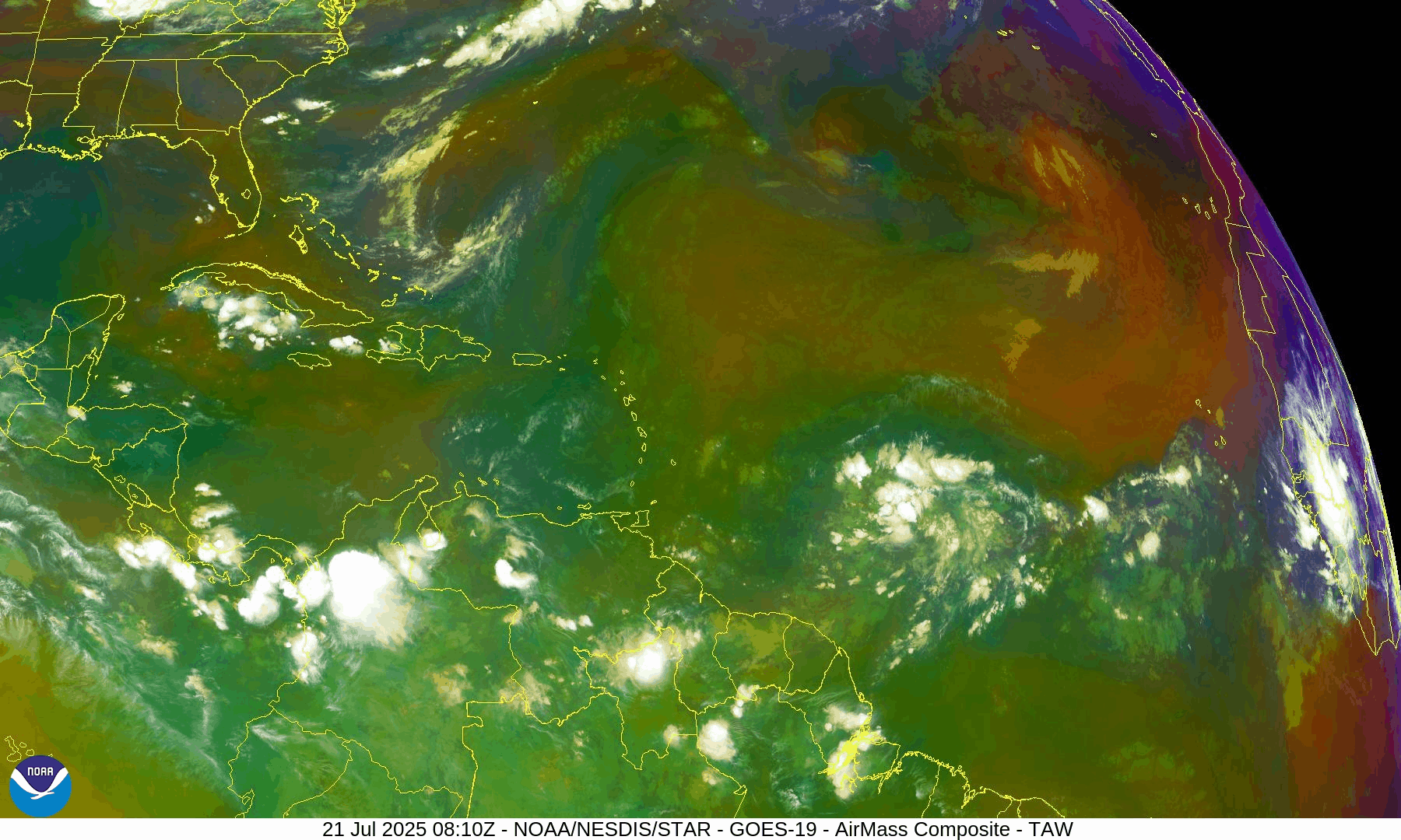
NOAA/NESDIS/STAR – GOES-19 Air Mass Composite – July 21, 2025
Sea Surface Temperatures (SSTs): Still Warm
Gulf of Mexico: 86–88°F – well above average
Western Caribbean: 85–87°F – supportive of development
Main Development Region (MDR): 82–84°F and climbing, with warm anomalies persisting
Warm waters throughout the basin provide the necessary energy for storms should other conditions align.
Sea Surface Temperature data courtesy of Windy.com
Wind Shear and Atmospheric Conditions

Wind Shear Courtesy of https://tropic.ssec.wisc.edu/
Shear remains moderate across much of the central and eastern Atlantic but is expected to weaken later in the week.
Moisture levels continue rising, particularly in the MDR and Caribbean.
Saharan Air Layer (SAL): Still present but beginning to thin slightly, particularly west of 40°W.
These factors collectively suggest improving potential for storm development by late July or early August.
Relative Humidity (ECMWF) data courtesy of Windy.com
Saharan Air Layer (Dust) data courtesy of Windy.com
Gulf of Mexico & Caribbean Outlook
A surface trough remains in the eastern Bay of Campeche, producing scattered thunderstorms.
Light to moderate winds (10–15 kt) dominate much of the Gulf, with seas around 3–5 feet.
Fresh winds (15–20 kt) and higher seas (6–8 ft) continue across parts of the south-central Caribbean.
Expect stronger trades and more convection near the Windward Passage and central Caribbean midweek as a tropical wave enters the region.
Wave height forecast (ECMWF Waves) courtesy of Windy.com
Surface pressure data (ECMWF) courtesy of Windy.com
Florida Forecast
Highs: Upper 80s to low 90s°F
Humidity: High
Rain Chances: Scattered afternoon thunderstorms, driven by sea breezes and instability
Winds: Light and variable, turning southeast near the coast
Hazards: Isolated strong storms possible with gusty winds and localized flooding
Rainfall forecast (ECMWF) courtesy of Windy.com
Prep Tip of the Day: Update Insurance and Inventory
Use this lull to get your disaster documentation in order:
Review your homeowners or renters insurance policy
Document your belongings via photos or video
Store digital backups in the cloud
Know your flood zone and verify your flood insurance coverage
Looking Ahead: Tropics Warming Up
While no tropical cyclone development is expected in the next 7 days, the overall pattern is becoming more favorable. Multiple waves in the deep tropics bear watching, and model guidance hints at potential activity in early August. We'll continue monitoring all waves for signs of organization.
Stay informed, stay prepared, and check back daily for updates from Cat5Prep.com.

Atlantic Hurricane Outlook – July 15, 2025: Gulf System Organizing, Tropics on Alert
A weak low over Florida is drifting into the Gulf of Mexico, producing heavy rain and prompting close monitoring. While development chances remain low, record-warm waters and shifting winds suggest more activity is coming.
The Atlantic remains officially quiet, but eyes are turning toward the Gulf of Mexico as a broad area of low pressure continues to develop. Though not yet a tropical depression, this system is producing heavy rainfall across parts of Florida and may slowly organize over the next few days. Elsewhere, warm sea surface temperatures and improving atmospheric conditions continue to set the stage for increased activity as July progresses.
Atlantic Basin: Watching the Gulf
As of this morning’s update from the National Hurricane Center (NHC):
No named tropical cyclones
One area of interest: Disturbance near Florida
Development potential: Low over 48 hours (10%), Slightly higher over 7 days (20%)
A broad, weak surface trough stretching across southern Florida is generating scattered storms and heavy rainfall. As it drifts westward into the Gulf of Mexico, slight development is possible—though wind shear and dry air may continue to limit its growth in the near term.
Regardless of tropical classification, this system is expected to bring:
Heavy rainfall across Florida and the Gulf Coast
Localized flash flooding
Coastal thunderstorms and rough surf
Satellite imagery courtesy of Windy.com
Sea Surface Temperatures: Primed and Warming
Waters across much of the Atlantic basin are running well above average:
Gulf of Mexico: 87–89°F (30–32°C) across much of the basin—ideal for storm formation
Caribbean Sea: Persistently warm, with temperatures near or above 86°F (30°C)
Main Development Region (MDR): Trending well above average for mid-July
This level of ocean heat content supports rapid intensification potential for any system that organizes in the coming weeks.
Sea Surface Temperature (ECMWF Analysis) courtesy of Windy.com
Atmospheric Conditions: Becoming More Favorable

Wind Shear Courtesy of https://tropic.ssec.wisc.edu/
Wind Shear: Moderate across the Gulf and Caribbean, but forecast models show a gradual easing through late week
Moisture Levels: Improving, especially in the western Caribbean and southern Gulf
Upper-Level Winds: Starting to show a less hostile pattern over the Gulf and MDR
Overall, the atmospheric profile is trending toward neutral to favorable—a subtle but important change.
Relative Humidity data (ECMWF) courtesy of Windy.com
Saharan Air Layer (SAL): Retreating Slowly
Dry air remains across parts of the eastern Atlantic but is beginning to loosen its grip:
Still suppressing deep convection off the African coast
Expected to retreat westward and weaken through the next 7–10 days
This transition opens the door for tropical waves to survive and organize
Saharan Air Layer (Dust) data courtesy of Windy.com
Florida & Gulf Coast Forecast: Wet and Stormy
The disturbance currently over Florida is impacting much of the region:
Florida Peninsula
Scattered to widespread showers and storms today
Localized flooding possible, especially in urban areas
Highs in the upper 80s to low 90s°F
Northern Gulf Coast (AL/MS/FL Panhandle)
Cloudier skies and increasing storms through tomorrow
Elevated rainfall totals possible
Winds 10–20 mph with gusty thunderstorms
Radar imagery courtesy of Windy.com
Prep Tip of the Day: Secure Outdoor Items
With storms increasing across the Southeast:
Bring in or secure loose outdoor items like patio furniture, garden tools, and trash bins
Clear storm drains and gutters to reduce urban flooding risk
Monitor flash flood alerts in flood-prone neighborhoods
Looking Ahead: A Pattern Shift Is Coming
Although no named systems are expected in the next few days, the Gulf disturbance is a reminder that even weak systems can cause significant impacts. Sea surface temperatures and weakening wind shear are setting the table for development in the latter half of July.
Stay tuned, stay prepared, and check back daily with Cat5Prep for accurate, actionable updates.

Atlantic Hurricane Outlook – June 4, 2025: A Flicker on the Horizon
Though no storms are active, key hurricane ingredients are aligning fast. A developing low near the Southeast U.S. and rising SSTs suggest change is coming.
The fourth day of the 2025 Atlantic hurricane season opens with quiet skies—but a subtle shift is underway. For the first time this season, the National Hurricane Center (NHC) has flagged a potential area of interest offshore the southeastern United States. While development chances remain low, it’s a reminder that conditions are evolving and the atmosphere is beginning to stir.

Atlantic Basin: A New Watch Zone Emerges
As of this morning’s Tropical Weather Outlook from the NHC:
No active tropical cyclones
One area of interest off the Southeastern U.S. coast
No tropical development expected in the next 48 hours
Low (10%) chance of development over the next 7 days
A non-tropical low pressure area is forecast to form near or offshore the Southeast U.S. coast.
If it remains offshore, it may gradually acquire subtropical or tropical characteristics while drifting northeastward at 10–15 mph.
— NHC Forecaster Reinhart, June 4, 2025
No storm is expected soon—but it’s the first official mention of potential development this season.
Satellite imagery courtesy of Windy.com
Sea Surface Temperatures: Ready for Action
Warm waters across the Atlantic basin continue to deepen—creating an ideal foundation for future storm formation:
Gulf of Mexico: Running 2–4°F above average, with pockets exceeding 86°F (30°C)
Western Caribbean: SSTs remain high, particularly around Central America and Cuba
Main Development Region (MDR): Trending warmer than normal with gradual warming expected into late June
This warm ocean water is the primary energy source for hurricanes—and it’s already in place.
Sea surface temperature data courtesy of Windy.com
Wind Shear & Moisture: Storm Barriers Continue to Erode
Atmospheric conditions are shifting in a storm-friendly direction:
Wind shear is weakening in key zones like the Gulf and Caribbean
Moisture levels are rising at both low and mid-levels of the atmosphere
Vertical instability is increasing, supporting larger, longer-lasting thunderstorms
This transition increases the likelihood that disorganized storms could become organized systems.

Wind Shear Courtesy of https://tropic.ssec.wisc.edu/
Saharan Air Layer: Still a Barrier, But Fading
A broad plume of Saharan dust remains in the central and eastern Atlantic, offering temporary protection:
Suppresses convection
Inhibits thunderstorm growth
Raises wind shear and dry air intrusion
However, models show this SAL influence weakening by mid-to-late June, removing one of the final natural inhibitors.
Saharan Air Layer data courtesy of Windy.com
Thunderstorm Activity: Early Clues
Even in the absence of tropical storms, convective activity gives us clues about what's forming:
Western Caribbean & Bay of Campeche: Disorganized clusters of thunderstorms show signs of persistent convection
Southeastern U.S. Coast: Isolated convection associated with the developing non-tropical low
While nothing is organizing yet, this pattern often precedes early-season development.
Thunderstorm data courtesy of Windy.com
Florida Forecast: Muggy Mornings, Stormy Afternoons
Expect typical summer conditions today across the state:
North Florida: Highs in the upper 80s, mostly sunny, low humidity
Central Florida: Around 90°F, with isolated thunderstorms after 2 PM
South Florida: Mid-80s, high humidity, with a greater risk of scattered PM storms
Afternoon thunderstorms are normal—but they also signal increasing moisture and instability across the region.
Forecast radar data courtesy of Windy.com
Prep Tip of the Day: Snap and Store
With one system on the radar, now’s a good time to check off a simple but essential task:
📸 Take photos of your home, car, and valuables
☁️ Back up those images to the cloud or email them to yourself
🔒 These photos may be critical for insurance documentation after a storm
Also:
Review your hurricane kit and evacuation plan
Sign up for emergency text alerts from local agencies
Bookmark trusted resources like Cat5Prep.com and hurricanes.gov
Looking Ahead: A Season Starting to Stir
It’s still early in the season, but we’re beginning to see motion on the map:
Warm water and shifting winds are laying the groundwork
The Saharan Air Layer is fading
Thunderstorm activity is creeping into critical regions
Today’s 10% chance of development is low—but it may mark the quiet season’s turning point.
We'll continue tracking changes in the Atlantic and bring you updated guidance each day.
Check back tomorrow for your next hurricane update from Cat5Prep.com.