
Atlantic Hurricane Outlook – July 28, 2025: Waves Active, Tropics Stable for Now
Tropical waves are stirring across the Atlantic, but no development is expected over the next 7 days. Warm waters and weakening wind shear suggest conditions could shift heading into August.

*Those who like data, continue reading. Those it prefer the quick version, jump to the TL;DR here.
As the final days of July unfold, the Atlantic basin remains active with several tropical waves but no immediate threats. While sea surface temperatures and atmospheric moisture continue to support development, upper-level wind shear and dry air are keeping conditions broadly stable—though this pattern may shift as we enter August.
Atlantic Basin: Multiple Waves, No Cyclones (Yet)
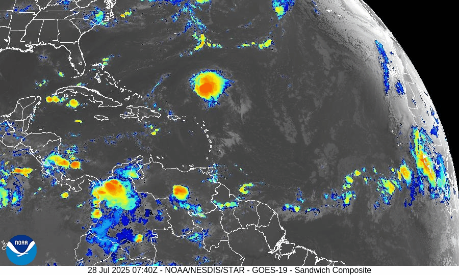
As of 8:00 AM EDT from the National Hurricane Center:
No active tropical cyclones
Two tropical waves are under watch:
Tropical Wave 1: Located near 40°W, moving westward at 10–15 kt with scattered convection. Still disorganized but under observation.
Tropical Wave 2: Recently emerged off Africa near 23°W, with convection along its southern flank. It’s embedded in a moist environment and will be monitored for future development.
No development expected over the next 7 days, but long-range models suggest increasing favorability for late next week.
Gulf of Mexico: Moisture Returns, But No Development
A weak surface trough lingers in the Bay of Campeche, producing isolated showers and thunderstorms.
No signs of tropical development at this time.
Expect scattered showers and storms across the eastern and central Gulf through Tuesday, driven by daytime heating and lingering mid-level moisture.
Caribbean Sea: Typical Summer Conditions
Fresh to strong trades continue in the central and southwest Caribbean, particularly off the coasts of Colombia and Venezuela.
Some isolated thunderstorms are active near Panama and the Windward Passage.
A tropical wave moving through the eastern Caribbean is enhancing convection, but remains disorganized.
Atlantic Main Development Region (MDR): Slowly Activating
Sea surface temperatures (SSTs):
MDR: 28–29°C (82–84°F), well above climatological norms.
Gulf and Caribbean: 30–31°C (86–88°F), fuel-ready.
Saharan Air Layer (SAL): Dry air continues to suppress convection over much of the MDR, but signs show it is beginning to weaken, allowing thunderstorm clusters to persist longer.
Wind shear: Still present in the central Atlantic, but trending downward.
SST data courtesy of Windy.com
Florida Outlook: Typical Late-July Storms
North Florida: Partly sunny with highs in the upper 80s. Afternoon storms possible.
Central Florida: Hot and humid (highs ~91°F) with scattered PM thunderstorms likely.
South Florida: Muggy with highs in the upper 80s. Thunderstorms expected after 2 PM.
Radar imagery courtesy of Windy.com
Prep Tip of the Day: Inventory Your Storm Gear
Now is a good time to audit your hurricane kit:
Check expiration dates on food, batteries, and meds.
Reassess your generator fuel supply and run a quick test.
Confirm family members know where the supplies are stored.
Looking Ahead: Eyes on Early August
While July is ending quietly, model ensembles hint at better organization potential in the MDR during the first 7–10 days of August.
A Kelvin wave (a burst of upper-level moisture and instability) may traverse the Atlantic next week, setting the stage for more robust wave activity.
TL;DR – July 28, 2025 Hurricane Snapshot
No active storms or tropical depressions
Two tropical waves being watched, neither near development
Gulf and Caribbean: Moist, unsettled, but not organized
MDR: Warm and slowly transitioning to a more favorable pattern
Florida: Classic summer pattern — hot, humid, and stormy afternoons
Outlook: Low risk this week, but August may bring change
Stay informed at Cat5Prep.com, and use this calm to finalize your preparations.

Atlantic Hurricane Outlook – June 6, 2025: Quiet Tropics, No Development Expected
June 6, 2025: No named storms or tropical threats in the Atlantic basin today, but signs of change are emerging. Sea surface temperatures continue to climb, and wind shear may weaken in the coming weeks. Now’s the time to review your hurricane prep plan.
The 2025 Atlantic hurricane season continues with a calm week, as no tropical cyclones or areas of concern are present. The National Hurricane Center (NHC) confirms no tropical development is expected over the next seven days, marking a quiet yet cautious start to June.

Atlantic Basin: Clear Skies for Now
From the 8 AM EDT Tropical Weather Outlook issued June 6:
No active tropical cyclones
No areas of concern
No development expected in the next seven days
The NHC’s maps and guidance reflect this assessment, indicating a continued quiet period. Notably, previous offshore coastal disturbances have been dropped and are no longer being tracked.
Satellite imagery courtesy of Windy.com
Sea Surface Temperatures: Stable But Still Warm
Warm SSTs persist in regions key to hurricane development:
Gulf of America (Mexico) & Western Caribbean: Remain seasonally warm (low to mid-80s°F)
Main Development Region (MDR): Still trending above normal for early June
While SSTs provide essential fuel, other atmospheric factors currently suppress development.
Sea surface temperature data courtesy of Windy.com
Wind Shear & Moisture: Conditions Not Yet Favorable
Wind Shear: Moderate across much of the basin, particularly in the western Caribbean and central Atlantic
Atmospheric Moisture: Rising gradually, but not yet supportive of storm formation
These conditions reduce the likelihood of tropical development in the immediate future.

Wind Shear Courtesy of https://tropic.ssec.wisc.edu/
Saharan Air Layer: Suppression in Full Effect
A strong plume of Saharan dust continues to suppress Atlantic convection:
Dry air and elevated shear persist across the eastern tropical Atlantic and MDR apnews.com
The SAL remains a key barrier to any early-season system development
Expect this barrier to weaken later in June
Saharan Air Layer (SAL) dust data courtesy of Windy.com
Thunderstorm Activity: Localized, Non-Tropical
Florida & Southeastern U.S.: Scattered afternoon thunderstorms—normal for this season
Western Caribbean: Isolated, disorganized showers and storms with no rotation
Eastern U.S. Coast: No significant organized convection detected
These are routine summer thunderstorms—not tropical systems.
Thunderstorm forecast data courtesy of Windy.com
Florida Forecast: Typical Early Summer Conditions
Expect another classic June day:
Highs: Upper 80s to low 90s°F (31–33 °C)
Humidity: Moderate to high, creating muggy conditions
Rain: Scattered afternoon and evening showers likely
Winds: Light and variable
Rainfall forecast data courtesy of Windy.com
Prep Tip of the Day: Emergency Alerts and Insurance
Take advantage of today’s calm to:
Confirm your emergency alert subscriptions, including text and email
Review your insurance coverage and update policy details if needed
Gather digital and physical copies of critical documents
Familiarize yourself with evacuation zones in your area
Looking Ahead: Still Calm, But Stay Vigilant
NHC projections show no tropical development through June 13–14, but underlying conditions—particularly warm waters and gradually weakening shear—will become increasingly favorable. The primary barriers are the Saharan dust layer and fluctuating atmospheric moisture.
Remember: hurricanes can form quickly when conditions align. Continue to monitor daily forecasts at Cat5Prep.com.