

Atlantic Hurricane Outlook – July 25, 2025: Gulf Disturbance Monitored, Basin Remains Broadly Quiet
Stay updated on the Atlantic hurricane season: July 25, 2025. A weak Gulf disturbance brings rain to Texas & Louisiana, while the broader Atlantic remains quiet with no immediate threats. Prepare now for August!

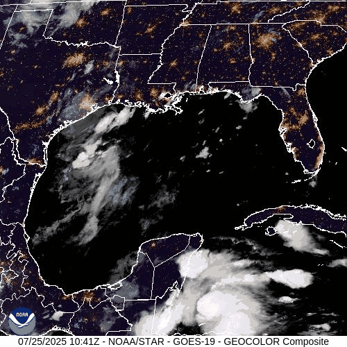
As we close out the final week of July, the Atlantic basin remains broadly quiet. The only area of interest remains a weak disturbance in the western Gulf of Mexico, which continues to produce showers but shows little sign of organizing. Elsewhere, several tropical waves are making their westward march across the Atlantic, but no significant development is expected in the short term.
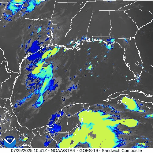
Gulf of Mexico: Weak Trough Brings Rain, Low Development Risk
A surface trough remains draped across the western Gulf of Mexico, generating scattered showers and isolated thunderstorms—particularly offshore of Texas and Louisiana.
The disturbance remains disorganized, with no closed low-level circulation.
Wind shear and surrounding dry air continue to limit development potential.
The National Hurricane Center (NHC) gives this system a low (10%) chance of development over the next 7 days.
However, heavy downpours and localized flooding remain possible across parts of coastal Texas and southwestern Louisiana today.
This weak trough is expected to gradually dissipate as it moves slowly westward.
Atlantic Basin: Multiple Waves, No Immediate Threats
The broader Atlantic remains seasonally active with several tropical waves but no current threats:
Tropical wave near 50°W: Moving westward with scattered convection; not showing signs of organization.
New wave near 23°W, just off the coast of Africa: Tracking westward along the monsoon trough with convection near its southern flank.
A weak low embedded in the monsoon trough near 08N44W is helping spark convection but lacks any closed circulation.
None of these features show signs of imminent development, though they will be monitored closely in the coming days.

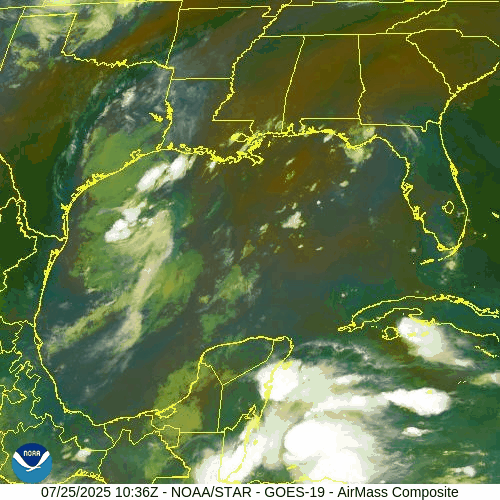
NOAA/NESDIS/STAR – GOES-19 Air Mass Composite – July 25, 2025
Sea Surface Temperatures & Atmospheric Conditions
Sea Surface Temperatures (SSTs) across the Gulf of Mexico and Main Development Region (MDR) remain well above average, supplying ample fuel for tropical development later this season.
Wind Shear remains moderate in the central and western Atlantic, limiting near-term organization.
The Saharan Air Layer (SAL) continues to suppress convection across much of the eastern Atlantic, especially north of the MDR.
Dust & SAL data from Windy.com
Florida Forecast: Typical Summer Pattern
Today’s outlook for Central Florida includes:
Highs in the low 90s°F (32–34°C)
Humidity: High, with heat indices nearing the upper 90s
Rain Chances: Scattered afternoon thunderstorms, driven by sea breeze and daytime heating
Winds: Light and variable, shifting southeast in the afternoon
No tropical impacts are expected for Florida at this time.
Radar imagery courtesy of Windy.com
Prep Tip of the Day: Review Your Evacuation Routes
Use this quiet period to refresh your storm plan:
Know your local evacuation zones
Map out primary and alternate routes
Keep a printed copy in your emergency kit in case power or cell service goes down
Share your plan with family or household members
Looking Ahead: Tropics Likely to Awaken in August
While the Atlantic basin remains quiet for now, the underlying signals—record SSTs, westward-moving waves, and easing shear—suggest a more favorable environment could emerge as we enter August. Stay alert, stay prepared, and keep checking in for daily updates.

Atlantic Hurricane Outlook – June 4, 2025: A Flicker on the Horizon
Though no storms are active, key hurricane ingredients are aligning fast. A developing low near the Southeast U.S. and rising SSTs suggest change is coming.
The fourth day of the 2025 Atlantic hurricane season opens with quiet skies—but a subtle shift is underway. For the first time this season, the National Hurricane Center (NHC) has flagged a potential area of interest offshore the southeastern United States. While development chances remain low, it’s a reminder that conditions are evolving and the atmosphere is beginning to stir.

Atlantic Basin: A New Watch Zone Emerges
As of this morning’s Tropical Weather Outlook from the NHC:
No active tropical cyclones
One area of interest off the Southeastern U.S. coast
No tropical development expected in the next 48 hours
Low (10%) chance of development over the next 7 days
A non-tropical low pressure area is forecast to form near or offshore the Southeast U.S. coast.
If it remains offshore, it may gradually acquire subtropical or tropical characteristics while drifting northeastward at 10–15 mph.
— NHC Forecaster Reinhart, June 4, 2025
No storm is expected soon—but it’s the first official mention of potential development this season.
Satellite imagery courtesy of Windy.com
Sea Surface Temperatures: Ready for Action
Warm waters across the Atlantic basin continue to deepen—creating an ideal foundation for future storm formation:
Gulf of Mexico: Running 2–4°F above average, with pockets exceeding 86°F (30°C)
Western Caribbean: SSTs remain high, particularly around Central America and Cuba
Main Development Region (MDR): Trending warmer than normal with gradual warming expected into late June
This warm ocean water is the primary energy source for hurricanes—and it’s already in place.
Sea surface temperature data courtesy of Windy.com
Wind Shear & Moisture: Storm Barriers Continue to Erode
Atmospheric conditions are shifting in a storm-friendly direction:
Wind shear is weakening in key zones like the Gulf and Caribbean
Moisture levels are rising at both low and mid-levels of the atmosphere
Vertical instability is increasing, supporting larger, longer-lasting thunderstorms
This transition increases the likelihood that disorganized storms could become organized systems.

Wind Shear Courtesy of https://tropic.ssec.wisc.edu/
Saharan Air Layer: Still a Barrier, But Fading
A broad plume of Saharan dust remains in the central and eastern Atlantic, offering temporary protection:
Suppresses convection
Inhibits thunderstorm growth
Raises wind shear and dry air intrusion
However, models show this SAL influence weakening by mid-to-late June, removing one of the final natural inhibitors.
Saharan Air Layer data courtesy of Windy.com
Thunderstorm Activity: Early Clues
Even in the absence of tropical storms, convective activity gives us clues about what's forming:
Western Caribbean & Bay of Campeche: Disorganized clusters of thunderstorms show signs of persistent convection
Southeastern U.S. Coast: Isolated convection associated with the developing non-tropical low
While nothing is organizing yet, this pattern often precedes early-season development.
Thunderstorm data courtesy of Windy.com
Florida Forecast: Muggy Mornings, Stormy Afternoons
Expect typical summer conditions today across the state:
North Florida: Highs in the upper 80s, mostly sunny, low humidity
Central Florida: Around 90°F, with isolated thunderstorms after 2 PM
South Florida: Mid-80s, high humidity, with a greater risk of scattered PM storms
Afternoon thunderstorms are normal—but they also signal increasing moisture and instability across the region.
Forecast radar data courtesy of Windy.com
Prep Tip of the Day: Snap and Store
With one system on the radar, now’s a good time to check off a simple but essential task:
📸 Take photos of your home, car, and valuables
☁️ Back up those images to the cloud or email them to yourself
🔒 These photos may be critical for insurance documentation after a storm
Also:
Review your hurricane kit and evacuation plan
Sign up for emergency text alerts from local agencies
Bookmark trusted resources like Cat5Prep.com and hurricanes.gov
Looking Ahead: A Season Starting to Stir
It’s still early in the season, but we’re beginning to see motion on the map:
Warm water and shifting winds are laying the groundwork
The Saharan Air Layer is fading
Thunderstorm activity is creeping into critical regions
Today’s 10% chance of development is low—but it may mark the quiet season’s turning point.
We'll continue tracking changes in the Atlantic and bring you updated guidance each day.
Check back tomorrow for your next hurricane update from Cat5Prep.com.

Atlantic Hurricane Outlook – June 2, 2025: A Quiet Morning, But Don’t Get Comfortable
June 2, 2025 Atlantic hurricane update: Calm skies for now, but unusually warm sea surface temperatures and shifting atmospheric conditions could spark activity later this month. Stay prepared with the latest forecasts and safety tips.
The second day of the 2025 Atlantic hurricane season begins under calm skies, but seasoned forecasters know better than to be lulled by the stillness. With sea temperatures running hot and atmospheric patterns shifting toward favorability, this quiet start may not last long.
Atlantic Basin: All Clear—For Now
As of this morning’s update from the National Hurricane Center (NHC), there are no active tropical cyclones, no areas of interest, and no tropical development expected over the next seven days.
This early-season lull is common in the first half of June, but warm waters and waning atmospheric inhibitors are quietly setting the stage for activity later this month.
Satellite data courtesy of Windy.com
Ocean Heat: The Hidden Fuel Source
Sea surface temperatures (SSTs) across the Atlantic basin are unusually high for this time of year—creating the potential for rapid storm intensification when development does occur:
Gulf of America (Mexico): Running 2–4°F above average, with large swaths above 86°F (30°C)
Caribbean Sea: Above-average temperatures, especially in the western basin
Main Development Region (MDR): Continuing to trend hot
Warm water is the engine that powers tropical cyclones, and the basin is already running well above operating temperature.
Sea surface temperature (SST) data courtesy of Windy.com
ENSO Status: La Nada Means No Safety Net
The El Niño–Southern Oscillation (ENSO) remains in a neutral phase, a state meteorologists often refer to as "La Nada."
El Niño has ended, removing the high wind shear that often suppresses Atlantic hurricanes
La Niña has not yet begun, but conditions may be trending in that direction later this summer
Neutral ENSO removes large-scale inhibitors, allowing the Atlantic to operate unchecked
Historically, neutral ENSO years correlate with average to above-average tropical storm activity.
Wind data courtesy of Windy.com
Saharan Air Layer: Dust Still Offers a Buffer—for Now
The Saharan Air Layer (SAL) continues to stretch across the tropical Atlantic, providing a temporary shield against storm formation:
Introduces dry, stable air into the atmosphere
Inhibits convection and cloud development
Increases wind shear in the central Atlantic
The SAL typically weakens by late June, making it easier for tropical waves to grow and organize.
Saharan Air Layer (SAL) dust data courtesy of Windy.com
Florida Forecast: A Summer Day with a Side of Humidity
Today’s conditions across Florida reflect typical early-June weather:
North Florida: Highs in the upper 80s, low humidity, and mostly sunny skies
Central Florida: Highs around 90°F, building humidity, and isolated afternoon storms
South Florida: Warm and muggy with highs in the mid-80s and a greater chance of scattered storms after 2 PM
It’s a classic Florida day—but the kind that often precedes the real tropical drama in July and August.
Weather radar forecast data courtesy of Windy.com
Prep Tips: Take Advantage of the Calm
With no storms on the map, today is a perfect day to prepare:
Review your hurricane plan and evacuation routes
Restock your hurricane kit
Double-check home insurance coverage
Take photos of property and valuables
Sign up for local emergency alerts
Bookmark trusted sources like Cat5Prep.com and the National Hurricane Center
Looking Ahead: Eyes on the Tropics
We remain in a short-term window of calm, but all indicators suggest that activity will ramp up in the coming weeks. Record-breaking sea surface temperatures and favorable upper-atmospheric trends point to early-season development potential later in June.
Stay alert. Stay ready. And check back tomorrow for your next update from Cat5Prep.

*As an Amazon Associate, we earn from qualifying purchases.