
Atlantic Hurricane Outlook – June 3, 2025: Conditions Ripening Beneath the Calm
The third day of the 2025 Atlantic hurricane season begins much like the last—quiet skies and no named systems. But meteorologists are watching closely. While there are no storms on the map, the ingredients for tropical cyclone formation are slowly assembling. Sea surface temperatures are rising, atmospheric inhibitors are weakening, and thunderstorm activity is beginning to build in key regions. It’s still early—but don’t get too comfortable.
Atlantic Basin: New Area of Interest and Overall Quiet
As of yesterday afternoon’s update from the National Hurricane Center (NHC), a new area of low pressure has been identified just off the southeastern United States coast:
A non-tropical area of low pressure is expected to form near or offshore of the southeastern U.S. coast in the next couple of days.
If it remains offshore, it could gradually acquire subtropical or tropical characteristics later this week while tracking northeastward at 10 to 15 mph.
Formation chance through 48 hours: Low (near 0%)
Formation chance through 7 days: Low (10%)
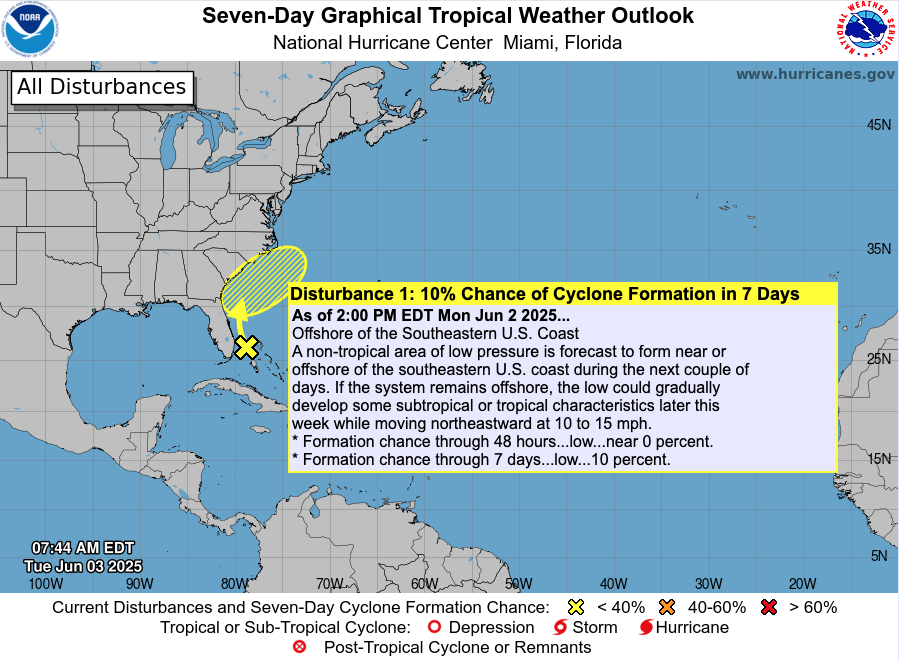
While development is currently unlikely, this is the first flagged area of interest in the Atlantic this season — a reminder that conditions are slowly trending more favorable. Models will continue to be monitored for any shifts in track or intensity.
At this time, no direct impacts are expected for the U.S. mainland, but boaters and beachgoers along the Southeast Coast should monitor local marine conditions later this week.
Otherwise, the basin remains quiet:
No active tropical cyclones
No other areas of interest
No tropical development expected in the next 7 days
A quiet start like this is typical for early June but it’s not a signal to let your guard down. The long-range outlook hints at increasing activity potential by mid-to-late June, especially in the western Caribbean and Gulf of America (Mexico).
Satellite imagery courtesy of Windy.com
Sea Surface Temperatures: Storm Fuel Is Already in Place
Warm waters are the engine that powers hurricanes, and the Atlantic is already running hot:
Gulf of America (Mexico): 2–4°F above average, with widespread 86°F+ (30°C) readings
Western Caribbean: Elevated SSTs continue to build near Central America and Cuba
Main Development Region (MDR): Trending warmer than normal, with the potential to support long-track storms later this season
These above-average temperatures are primed to support rapid intensification once storm systems begin to form.
Sea surface temperature data courtesy of Windy.com
Wind Shear & Moisture: A Shifting Balance
Wind shear—the atmospheric force that disrupts hurricane development—is weakening, especially in the Caribbean and Gulf. At the same time, moisture levels in the lower and mid-atmosphere are rising.
This combination supports stronger thunderstorms and vertical cloud development—key precursors for tropical formation.
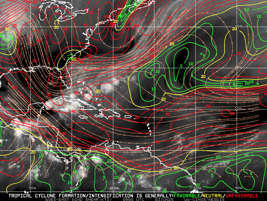
Wind-shear Map Image Courtesy of : https://tropic.ssec.wisc.edu/
Saharan Air Layer: Dust Is Holding Steady—for Now
A broad stretch of the Saharan Air Layer (SAL) is still active across the central and eastern Atlantic:
Dry, stable air disrupts tropical wave development
Increased wind shear limits vertical convection
Dust particles reduce storm cloud organization
While the SAL continues to offer some protection in the eastern Atlantic, it’s expected to weaken later this month—removing one of the last early-season barriers to storm growth.
Satellite dust data courtesy of Windy.com
Thunderstorm Activity: Not Just Summer Weather
While today’s thunderstorms aren’t tropical, their growing presence is important:
Western Caribbean: Clusters of convection are forming, though currently disorganized
Southeastern U.S. & Gulf Coast: Expect afternoon storms, fueled by heat and humidity
These storm systems help prime the atmosphere for eventual tropical development and are often the earliest signs of areas of interest.
Thunderstorm data courtesy of Windy.com
Florida Forecast: A Classic, Stormy Summer Day
Expect another typical early June day across the Sunshine State:
North Florida: Upper 80s, low humidity, mostly clear
Central Florida: Around 90°F with building humidity and scattered PM storms
South Florida: Mid-80s, muggy, with increased chances of storms after 2 PM
Though today’s storms are not tropical, the overall pattern is signaling a slow seasonal transition.
Forecast radar imagery courtesy of Windy.com
Prep Tip of the Day: Get Ahead While It’s Quiet
This calm window is the perfect time to prepare:
Review your hurricane plan and local evacuation routes
Restock your hurricane kit—especially water, batteries, and medications
Take photos of your home and valuables for insurance
Sign up for local emergency alerts and bookmark Cat5Prep.com
Know the difference between a watch and a warning before one is issued
Looking Ahead: No Storms Now, But Don’t Let That Fool You
Though nothing is spinning in the Atlantic today, all signs point to rising potential in the weeks ahead. Sea temperatures are already warm enough to support hurricanes. Wind shear is fading. Moisture and thunderstorm activity are increasing.
We are not forecasting imminent development—but the environment is evolving fast.
Check back tomorrow for your daily hurricane update from Cat5Prep.com.