

Atlantic Hurricane Outlook – July 25, 2025: Gulf Disturbance Monitored, Basin Remains Broadly Quiet
Stay updated on the Atlantic hurricane season: July 25, 2025. A weak Gulf disturbance brings rain to Texas & Louisiana, while the broader Atlantic remains quiet with no immediate threats. Prepare now for August!

As we close out the final week of July, the Atlantic basin remains broadly quiet. The only area of interest remains a weak disturbance in the western Gulf of Mexico, which continues to produce showers but shows little sign of organizing. Elsewhere, several tropical waves are making their westward march across the Atlantic, but no significant development is expected in the short term.
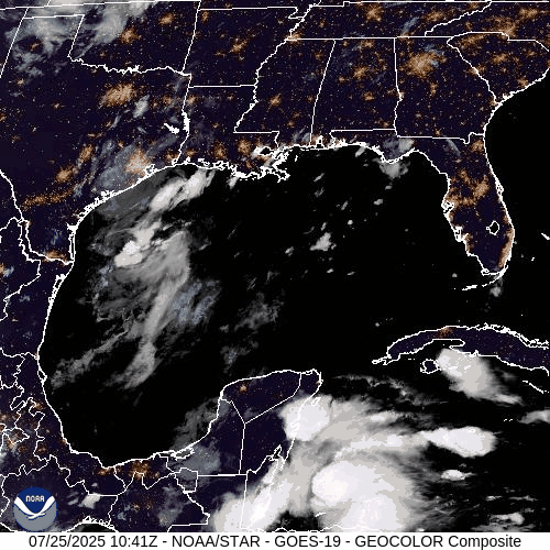
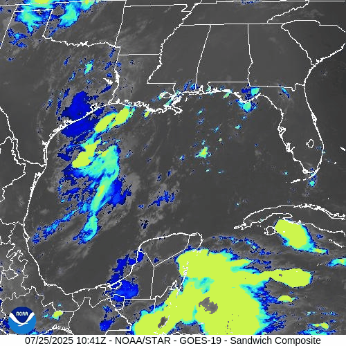
Gulf of Mexico: Weak Trough Brings Rain, Low Development Risk
A surface trough remains draped across the western Gulf of Mexico, generating scattered showers and isolated thunderstorms—particularly offshore of Texas and Louisiana.
The disturbance remains disorganized, with no closed low-level circulation.
Wind shear and surrounding dry air continue to limit development potential.
The National Hurricane Center (NHC) gives this system a low (10%) chance of development over the next 7 days.
However, heavy downpours and localized flooding remain possible across parts of coastal Texas and southwestern Louisiana today.
This weak trough is expected to gradually dissipate as it moves slowly westward.
Atlantic Basin: Multiple Waves, No Immediate Threats
The broader Atlantic remains seasonally active with several tropical waves but no current threats:
Tropical wave near 50°W: Moving westward with scattered convection; not showing signs of organization.
New wave near 23°W, just off the coast of Africa: Tracking westward along the monsoon trough with convection near its southern flank.
A weak low embedded in the monsoon trough near 08N44W is helping spark convection but lacks any closed circulation.
None of these features show signs of imminent development, though they will be monitored closely in the coming days.

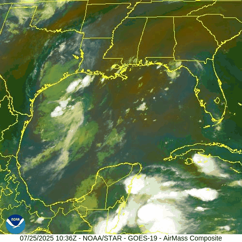
NOAA/NESDIS/STAR – GOES-19 Air Mass Composite – July 25, 2025
Sea Surface Temperatures & Atmospheric Conditions
Sea Surface Temperatures (SSTs) across the Gulf of Mexico and Main Development Region (MDR) remain well above average, supplying ample fuel for tropical development later this season.
Wind Shear remains moderate in the central and western Atlantic, limiting near-term organization.
The Saharan Air Layer (SAL) continues to suppress convection across much of the eastern Atlantic, especially north of the MDR.
Dust & SAL data from Windy.com
Florida Forecast: Typical Summer Pattern
Today’s outlook for Central Florida includes:
Highs in the low 90s°F (32–34°C)
Humidity: High, with heat indices nearing the upper 90s
Rain Chances: Scattered afternoon thunderstorms, driven by sea breeze and daytime heating
Winds: Light and variable, shifting southeast in the afternoon
No tropical impacts are expected for Florida at this time.
Radar imagery courtesy of Windy.com
Prep Tip of the Day: Review Your Evacuation Routes
Use this quiet period to refresh your storm plan:
Know your local evacuation zones
Map out primary and alternate routes
Keep a printed copy in your emergency kit in case power or cell service goes down
Share your plan with family or household members
Looking Ahead: Tropics Likely to Awaken in August
While the Atlantic basin remains quiet for now, the underlying signals—record SSTs, westward-moving waves, and easing shear—suggest a more favorable environment could emerge as we enter August. Stay alert, stay prepared, and keep checking in for daily updates.

Atlantic Hurricane Outlook – May 30, 2025: The Calm Before the Surge
Tropical Storm Alvin has formed in the Eastern Pacific, signaling the start of the 2025 season. While the Atlantic remains quiet, activity is brewing in the tropics. See SST, SAL, and EFI maps to track what's coming.
As we approach the official start of the Atlantic hurricane season on June 1, the Atlantic basin remains tranquil. The National Hurricane Center (NHC) reports no active tropical systems or significant disturbances across the Atlantic Ocean, Caribbean Sea, or Gulf of Mexico.
However, this period of calm may be short-lived. Environmental conditions—such as record-warm sea surface temperatures and a neutral El Niño–Southern Oscillation (ENSO) phase—are aligning to potentially fuel an active hurricane season.
Eastern Pacific Activity: Tropical Storm Alvin Forms
While the Atlantic remains quiet, the Eastern Pacific has seen its first named storm of the 2025 season: Tropical Storm Alvin.
Location: Approximately 565 miles south-southeast of the southern tip of Mexico’s Baja California Peninsula
Movement: Northwest at 12 mph
Maximum Sustained Winds: 60 mph
Forecast: Alvin is expected to strengthen through early Friday but is anticipated to weaken by late Friday as it encounters cooler waters
(Associated Press source)
Although Alvin poses no direct threat to land, its formation indicates that tropical activity is beginning in the Pacific.
Sea Surface Temperatures: Fuel for Future Storms
The Atlantic's sea surface temperatures (SSTs) are notably warm, providing ample energy for potential storm development:
Gulf of Mexico and Caribbean Sea: SSTs are running 2–4°F above average, with some areas exceeding 86°F (30°C)
North Atlantic: Experiencing its third-warmest May on record
These elevated temperatures are conducive to tropical cyclone formation and intensification.
Saharan Dust: A Temporary Inhibitor
The Saharan Air Layer (SAL) continues to transport dry, dusty air across the Atlantic, suppressing tropical development by:
Drying out the mid-level atmosphere
Increasing vertical wind shear
Inhibiting cloud formation
This dust presence is expected to diminish in the coming weeks, potentially allowing for increased tropical activity as the season progresses.
Preparation Tips: Stay Ready
With the Atlantic hurricane season imminent, it's crucial to visit our Prep Blog and:
Review Emergency Plans: Ensure evacuation routes and communication plans are up to date
Check Emergency Kits: Stock up on essentials like water, non-perishable food, medications, and batteries
Stay Informed: Monitor updates from the NHC and local weather services
Looking Ahead
While the Atlantic remains calm for now, the formation of Tropical Storm Alvin in the Pacific underscores the importance of vigilance. As environmental conditions become more favorable, the likelihood of tropical development in the Atlantic increases.
Stay prepared and stay informed.

*This is an Amazon affiliate link. We earn a commission if you buy through it.