
Atlantic Hurricane Outlook – July 31, 2025: Tropics Active But No Storms on the Horizon
Tropical waves continue to move across the Atlantic, but none show signs of organization. Saharan dust and wind shear are keeping storm development in check—for now.
*Those who like data, continue reading. Those it prefer the quick version, jump to the TL;DR here.
The Atlantic basin continues to host several tropical waves—but none are expected to organize into tropical cyclones over the next seven days. Despite warm seas and increasing moisture, wind shear and Saharan dry air maintain a suppressive environment.

Atlantic Basin Summary
As of the 8:00 AM EDT Tropical Weather Outlook (TWO) from the National Hurricane Center, there are:
No active tropical cyclones.
No areas under investigation for development in the next 48 hours or seven days.
The Tropical Weather Discussion (issued at ~12:15 UTC) reveals:
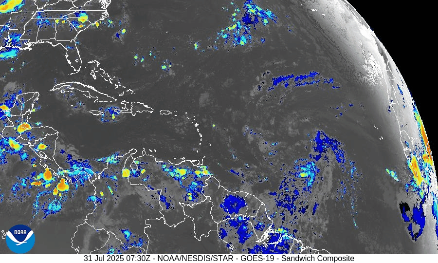
A tropical wave near 43°W (south of 22°N) moving westward at 10–15 kt, with scattered moderate convection between 4–10°N.
Another wave near 55°W (south of 18°N) moving west at about 10 kt, with minimal convection.
These waves are being monitored but show no organized structure or circulation at present.
Key Weather Factors
Sea Surface Temperatures (SSTs):
Across the Gulf of Mexico, Caribbean, and MDR, SSTs range from 29–31 °C (84–88 °F)—values supportive of tropical development if atmospheric conditions improve.
Wind Shear:
Remains moderate to high across most of the Atlantic basin, limiting vertical development of disturbances.
Saharan Air Layer (SAL):
Dry and dusty air persists across the central and eastern Atlantic, suppressing convection in the MDR.
Atmospheric Moisture:
While moisture is gradually increasing near the Caribbean and western tropical Atlantic, the dry air and shear continue to hinder system organization.
Gulf of America (Mexico) & Caribbean Region
No low-pressure areas or disturbances are being tracked.
A dominating high-pressure ridge supports generally light winds and calm seas across the Gulf and Caribbean.
Offshore rainfall remains typical for this time of year—no tropical impacts on the Florida peninsula.
GOES-19 - Sector view: Gulf of America - Sandwich
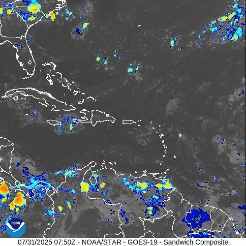
GOES-19 - Sector view: Caribbean - Sandwich
Florida Forecast
High temperatures: Near 90 °F under humid conditions.
Afternoon showers and thunderstorms: 40–50% likelihood due to sea breeze convergence.
Winds: Light and variable inland; east-southeasterly along the coast.
Precipitation: Not driven by tropical systems.
Rain forecast visualization courtesy of Windy.com
Preparation Tip: Review Your Evacuation Plan

Coast XP14R Flashlight
4500 lumen LED flashlight with Slide Focus®, USB-C recharge, and 5 light modes. Built for serious storm prep.
Take advantage of the lull to finalize your hurricane readiness:
Verify evacuation zones and travel routes.
Confirm alert registration with local and state emergency systems.
Update contact information and checklist locations with household members.
Outlook & Future Signal
Although today’s conditions remain tranquil, the ongoing wave train emerging from Africa and gradually improving moisture and SST profiles suggest that rainfall and organization potential may increase in early August.
TL;DR – July 31, 2025 Snapshot
No tropical systems present.
Two tropical waves travel west, but show none of the structure needed for development.
Strong wind shear and Saharan dust continue to suppress storm formation.
Warm waters and increased moisture hint at higher activity potential in August.
Stay informed and prepare while the pace allows. Daily updates continue at Cat5Prep.com.

Atlantic Hurricane Outlook – July 29, 2025: Active Waves, Quiet Forecast
Several tropical waves are moving across the Atlantic, but none show signs of imminent development. Warm waters persist, and August may bring change.
*Those who like data, continue reading. Those it prefer the quick version, jump to the TL;DR here.
Though the Atlantic basin remains free of tropical cyclones, several tropical waves are shifting across the ocean—each monitored for organization. Conditions remain broadly unfavorable for development, but the warm ocean and evolving atmospheric patterns suggest potential change in the weeks ahead.

Atlantic Basin: No Cyclones, But Several Waves in Motion
According to the latest Tropical Weather Outlook, the National Hurricane Center does not expect any tropical cyclone formation during the next seven days. However, recent Tropical Weather Discussion reveals:
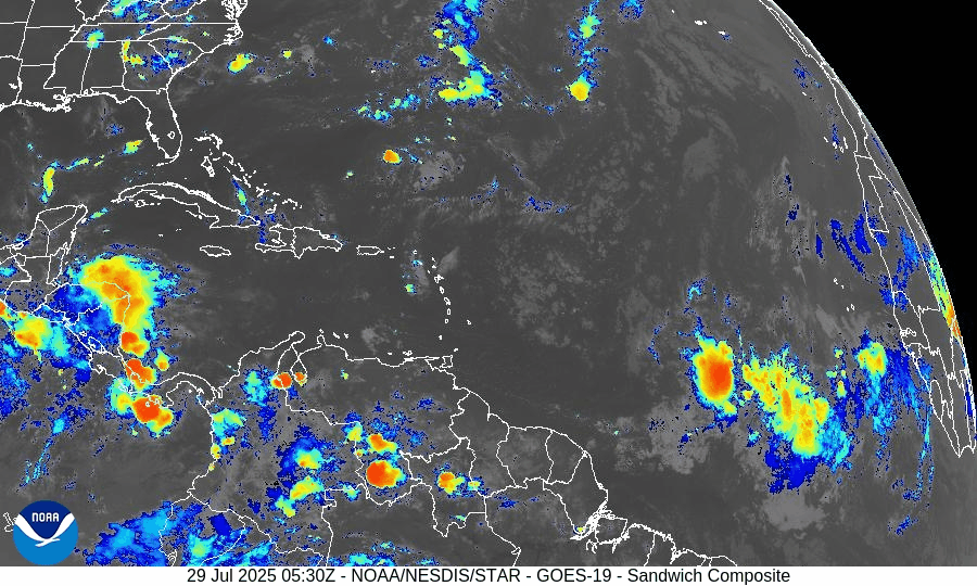
A tropical wave near 19°W (south of 19°N), moving westward at about 10 kt, with scattered convection between 10°N–13°N and east of 23°W.
Another wave near 38°W, south of 18°N, moving slowly (~5 kt), associated with a 1012 mb low. A scatterometer pass noted fresh to strong winds within 120 nm and scattered convection between 5°N–12°N.
None of these features currently exhibit a closed circulation or organization, but their movement into warmer waters bears monitoring.
Gulf of Mexico & Caribbean: Calm Signals, Minimal Development Risk
No disturbances are being tracked in the Gulf at this time.
Surface analyses and satellite imagery show mostly typical trade-wind patterns and minor convection near Central America and the Windward Passage.
A dominant high-pressure ridge maintains light to moderate winds and minimal seas across most of the region.
Environmental Snapshot: Barriers Remain, Fuel Accumulating
Sea surface temperatures across the Gulf of Mexico and western Caribbean are well above average, delivering ample heat energy for potential development in early August.
The Saharan Air Layer (SAL) continues to suppress convection in the eastern Atlantic. Convection in tropical waves remains shallow and short-lived.
Upper-level wind shear remains moderate to high, especially over the central MDR, limiting vertical storm organization.
SST data courtesy of Windy.com
Florida Forecast: Late-July Heat & Afternoon Storms
Highs across central and south Florida: Near 90–92 °F under humid conditions.
Rain chance: 40–50% with scattered afternoon showers and thunderstorms fueled by sea-breezes and daytime heating.
Wind conditions: Light and variable inland, becoming east-southeasterly near the coast.
No tropical impacts are anticipated over the next 24 hours.
Rain forecast visualization courtesy of Windy.com
Prep Tip of the Day: Keep Monitoring Those Waves

Midland WR120B Weather Radio
Stay safe with 60+ emergency alerts, alarm options, and localized programming in English, Spanish, or French.
Even when storms don’t form, their precursors still matter:
Review evacuation zones and routes now—not during an emergency.
Check the status of local email lists or alert systems for tropical watches.
Confirm your household has working weather radios and updated contact lists.
Looking Ahead: August May Bring Increased Activity
While development is unlikely in the next 5–7 days, the combination of:
Warm ocean temperatures,
Decreasing wind shear projections, and
Multiple tropical waves entering the MDR
suggests the system is slowly shifting toward a more favorable environment as August begins.
TL;DR

VINTAGE LIFE Trucker Hat
Distressed, unisex cap with bold LOCAL style and funny sayings. A must-have for any casual prepper.
Flood‑ready outlook for July 29, 2025
No tropical cyclones in the basin; no development expected this week.
Two tropical waves showing scattered convection—watching for mid‑Atlantic changes.
Warm Gulf and Caribbean waters offer fuel if shear and dry air ease up.
Florida sees typical summer weather—heat and scattered afternoon storms.
Prep recommendation: finalize hurricane plans, stay informed, remain ready.
For full updates, continue visiting Cat5Prep.com daily.


Atlantic Hurricane Outlook – June 19, 2025: Still Down South – Pacific Watches Erick
The Atlantic remains storm-free, but Hurricane Erick—a powerful Category 4 storm—gains strength in the Eastern Pacific. Learn what this means for the Atlantic basin and why now is the time to prepare.
The Atlantic basin remains quiet today, with no active tropical cyclones and no development expected over the next 7 days, according to the National Hurricane Center’s latest 2 AM and 8 AM EDT outlooks nhc.noaa.gov. While the Atlantic sleeps, attention is turning to a powerful system in the Pacific.
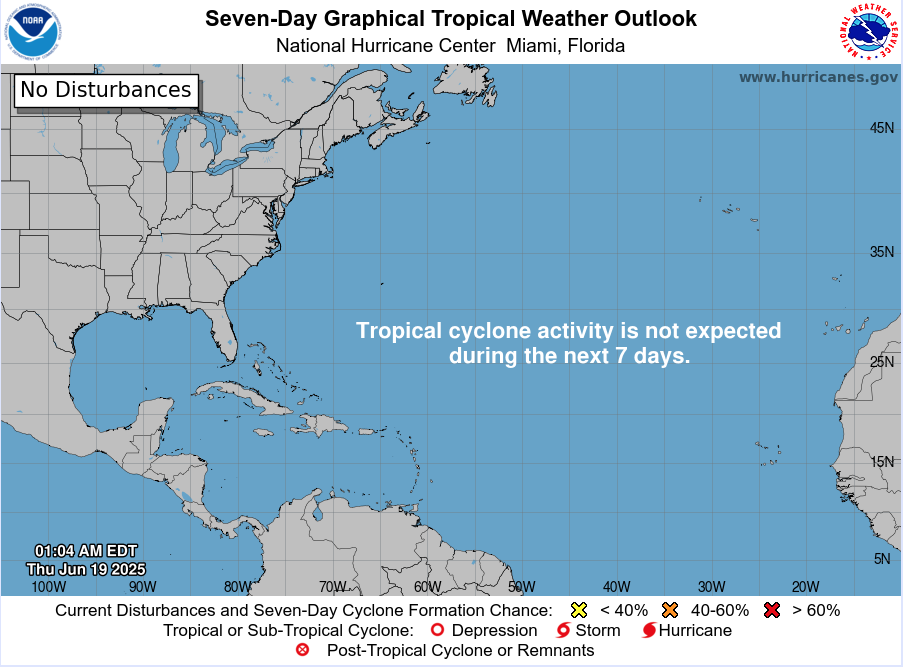
Atlantic Basin: Calm Waters, No Alerts
There are still no named storms or areas under tropical monitoring. The graphical and textual 7-day outlooks show zero development chance, meaning the basin continues its quiet stretch early in the season . Early June silence isn’t unusual—but with warm seas in place, conditions could shift quickly.
Satellite view via Windy.com
Pacific Perspective: Erick Now a Category 4
In the Eastern Pacific, Hurricane Erick has rapidly intensified into an “extremely dangerous” Category 4 storm with 145 mph sustained winds, now only about 70 miles west-southwest of Puerto Ángel, Mexico, heading for landfall.
This storm is expected to bring destructive winds, brutal rainfall (8–16 inches), mudslides, and severe coastal flooding across southern Mexico.


Sea Surface Temperatures: Atlantic Warming Continues
Gulf & Western Caribbean: SSTs remain warm at 84–88 °F, maintaining energy supply for potential tropical systems.
Main Development Region (MDR): Ocean temperatures are also above normal, setting the stage for Atlantic activity later in the season.
Sea Surface Temperature via Windy.com
Atmospheric Conditions: Suppressive Air Masses

Wind Shear Courtesy of https://tropic.ssec.wisc.edu/
Wind shear: Still moderate to high across key development areas, limiting near-term storm formation.
Saharan Air Layer (SAL): A persistent dust plume continues to suppress early-season activity in the eastern Atlantic.
Moisture: Slowly increasing in the Gulf and western Caribbean, helping build storm potential.
Saharan Air Layer (Dust) via Windy.com
Daily Weather: Standard June Patterns
Florida & Southeast U.S.: Afternoon and evening thunderstorms remain widespread but non-tropical.
Caribbean & Atlantic: Quiet and storm-free, with no signs of developing systems.
Air Quality: Possible haze in Florida due to advancing Saharan dust.
Thunderstorm Forecast (ECMWF) via Windy.com
Florida Forecast (June 19)
Highs: Upper 80s to low 90s °F (31–33 °C)
Humidity: High—typical muggy summer
Rain: Scattered PM showers and thunderstorms
Visibility: Hazy in some areas
Winds: Light, occasional gusts near storm cells
Rainfall Forecast (ECMWF) via Windy.com
Prep Tip of the Day: Cross-Basin Awareness
Even without Atlantic storms, Pacific activity underscores a critical point:
Monitor systems across basins, not just the Atlantic
Understand conditions building globally—warm seas, dust, wind shear shifts
Use this calm time to update emergency contacts, test NOAA radios, and finalize supply kits
Looking Ahead: Calm Now, But It Won’t Last
No Atlantic activity is expected this week, but elevated ocean temperatures, decreasing wind shear, and diminishing dust suggest a shift is coming. Hurricane Erick in the Pacific could hint at similar atmospheric boosts affecting the Atlantic soon.
Stay tuned for daily updates from Cat5Prep.com—the next tropical trigger could arrive sooner than you think.

*As an Amazon Associate, we earn from qualifying purchases.