
Atlantic Hurricane Outlook – August 10, 2025: Multiple tropical waves crossing the Atlantic; development chances gaining
Multiple tropical waves are moving across the Atlantic today, but Saharan dust, wind shear, and dry air are keeping development chances low. Warm ocean temperatures could allow for changes later this week.
Atlantic Basin Overview
TLDR Version; Jump Here
As of this morning, no named tropical cyclones are active in the Atlantic. Several tropical waves are traveling westward across the Main Development Region (MDR), but most are struggling with environmental challenges that limit development. Sea surface temperatures are amply warm, so these waves will continue to be monitored as they move toward more favorable conditions later this week.
Key Systems We’re Watching
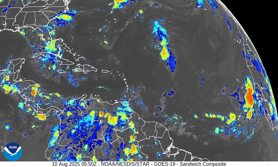
Central Atlantic Tropical Wave (~40°W):
Moving west at 10–15 knots with scattered convection. Organization remains limited due to dry air and moderate wind shear. Low chance of development over the next 7 days.Eastern Atlantic Tropical Wave (~23°W, off Africa):
Recently emerged from the continent with convection along its southern flank. Battling Saharan dust and dry air, keeping development chances low in the near term, potentially gaining strength in next 7-days.Monsoon Trough Low (~08N44W):
Embedded within the monsoon trough, sparking intermittent thunderstorm activity. No immediate signs of organized development.
GOES-19 - Sector view: Tropical Atlantic
GFS Future 8/18/25 - Curving NE off Coast of US
Euro Future 8/20/25 - Curving NE off Coast of US
Environmental Conditions
Sea Surface Temperatures (SSTs):
MDR running 28–29.5°C (82–85°F), with 29–31°C (84–88°F) in the Caribbean and Gulf of Mexico—plenty of fuel for storms if other conditions improve.Wind Shear:
Moderate to high shear in the central Atlantic is tilting storm structures and preventing vertical stacking of thunderstorms, slowing development.Moisture:
Humidity is increasing in the western tropical Atlantic, but dry air still lingers across much of the MDR.Saharan Air Layer (SAL):
Dry, dusty air extends across the eastern and central MDR, suppressing convection and capping short-term development potential.
Regional Outlooks
Gulf of Mexico:
No organized tropical disturbances. Typical summer thunderstorms will continue along coastal areas.Caribbean Sea:
Fresh trades persist in the south-central basin with occasional showers. No organized systems.U.S. Southeast & Florida:
Hot and humid with scattered sea-breeze thunderstorms each afternoon. No tropical threats expected today.
GOES-19 - Sector view: Gulf
GOES-19 - Sector view: Caribbean
Looking Ahead (5–10 Days)
The “wave train” from Africa will continue. As SAL weakens and shear pockets relax later this week, one of these waves could encounter a more favorable environment, especially in the central/western MDR.
Prep Reminder
This quiet stretch is the ideal time to review your hurricane plan, restock supplies, and confirm your household communication strategy.
TL;DR – August 10, 2025:
No active storms; several tropical waves in the MDR.
Development chances remain low in the short term due to SAL, wind shear, and patchy moisture.
Warm SSTs mean conditions could turn more favorable later this week. (Chance 70% Dev in next 7-days)
No tropical impacts expected for the U.S. today.

Atlantic Hurricane Outlook – June 4, 2025: A Flicker on the Horizon
Though no storms are active, key hurricane ingredients are aligning fast. A developing low near the Southeast U.S. and rising SSTs suggest change is coming.
The fourth day of the 2025 Atlantic hurricane season opens with quiet skies—but a subtle shift is underway. For the first time this season, the National Hurricane Center (NHC) has flagged a potential area of interest offshore the southeastern United States. While development chances remain low, it’s a reminder that conditions are evolving and the atmosphere is beginning to stir.

Atlantic Basin: A New Watch Zone Emerges
As of this morning’s Tropical Weather Outlook from the NHC:
No active tropical cyclones
One area of interest off the Southeastern U.S. coast
No tropical development expected in the next 48 hours
Low (10%) chance of development over the next 7 days
A non-tropical low pressure area is forecast to form near or offshore the Southeast U.S. coast.
If it remains offshore, it may gradually acquire subtropical or tropical characteristics while drifting northeastward at 10–15 mph.
— NHC Forecaster Reinhart, June 4, 2025
No storm is expected soon—but it’s the first official mention of potential development this season.
Satellite imagery courtesy of Windy.com
Sea Surface Temperatures: Ready for Action
Warm waters across the Atlantic basin continue to deepen—creating an ideal foundation for future storm formation:
Gulf of Mexico: Running 2–4°F above average, with pockets exceeding 86°F (30°C)
Western Caribbean: SSTs remain high, particularly around Central America and Cuba
Main Development Region (MDR): Trending warmer than normal with gradual warming expected into late June
This warm ocean water is the primary energy source for hurricanes—and it’s already in place.
Sea surface temperature data courtesy of Windy.com
Wind Shear & Moisture: Storm Barriers Continue to Erode
Atmospheric conditions are shifting in a storm-friendly direction:
Wind shear is weakening in key zones like the Gulf and Caribbean
Moisture levels are rising at both low and mid-levels of the atmosphere
Vertical instability is increasing, supporting larger, longer-lasting thunderstorms
This transition increases the likelihood that disorganized storms could become organized systems.

Wind Shear Courtesy of https://tropic.ssec.wisc.edu/
Saharan Air Layer: Still a Barrier, But Fading
A broad plume of Saharan dust remains in the central and eastern Atlantic, offering temporary protection:
Suppresses convection
Inhibits thunderstorm growth
Raises wind shear and dry air intrusion
However, models show this SAL influence weakening by mid-to-late June, removing one of the final natural inhibitors.
Saharan Air Layer data courtesy of Windy.com
Thunderstorm Activity: Early Clues
Even in the absence of tropical storms, convective activity gives us clues about what's forming:
Western Caribbean & Bay of Campeche: Disorganized clusters of thunderstorms show signs of persistent convection
Southeastern U.S. Coast: Isolated convection associated with the developing non-tropical low
While nothing is organizing yet, this pattern often precedes early-season development.
Thunderstorm data courtesy of Windy.com
Florida Forecast: Muggy Mornings, Stormy Afternoons
Expect typical summer conditions today across the state:
North Florida: Highs in the upper 80s, mostly sunny, low humidity
Central Florida: Around 90°F, with isolated thunderstorms after 2 PM
South Florida: Mid-80s, high humidity, with a greater risk of scattered PM storms
Afternoon thunderstorms are normal—but they also signal increasing moisture and instability across the region.
Forecast radar data courtesy of Windy.com
Prep Tip of the Day: Snap and Store
With one system on the radar, now’s a good time to check off a simple but essential task:
📸 Take photos of your home, car, and valuables
☁️ Back up those images to the cloud or email them to yourself
🔒 These photos may be critical for insurance documentation after a storm
Also:
Review your hurricane kit and evacuation plan
Sign up for emergency text alerts from local agencies
Bookmark trusted resources like Cat5Prep.com and hurricanes.gov
Looking Ahead: A Season Starting to Stir
It’s still early in the season, but we’re beginning to see motion on the map:
Warm water and shifting winds are laying the groundwork
The Saharan Air Layer is fading
Thunderstorm activity is creeping into critical regions
Today’s 10% chance of development is low—but it may mark the quiet season’s turning point.
We'll continue tracking changes in the Atlantic and bring you updated guidance each day.
Check back tomorrow for your next hurricane update from Cat5Prep.com.