
Atlantic Hurricane Outlook – October 9, 2025
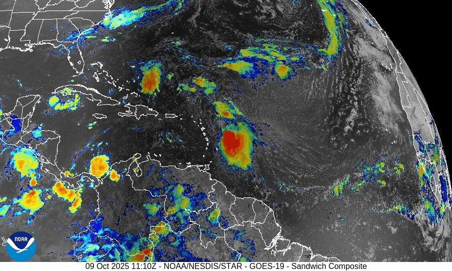
On October 9, Tropical Storm Jerry continues to strengthen in the central Atlantic with sustained winds near 65 mph. The storm is forecast to become a hurricane within 24–48 hours as it tracks west-northwest toward the northern Leeward Islands. Meanwhile, a disturbance in the Bay of Campeche carries only a 10% development chance. Florida and the Gulf of America remain calm aside from elevated surf and rip currents.

Tropical Storm Jerry continues west-northwest; likely intensification ahead; Gulf disturbance still low probability
Atlantic Basin Overview
Tropical Storm Jerry
Jerry remains active in the Atlantic, located about 355 miles east-southeast of the northern Leeward Islands, moving west-northwest at ~20 mph, with sustained winds near 65 mph.
The system is expected to strengthen into a hurricane by Friday or Saturday, as conditions favor further intensification.
A tropical storm watch is in effect for islands such as Antigua, Barbuda, and St. Kitts as Jerry approaches.Gulf / Bay of Campeche Disturbance
A broad area of showers and thunderstorms continues in the Bay of Campeche with only a 10% chance of development per current outlooks over the next 48 hours and 7 days.
Environmental Conditions
Sea Surface Temperatures (SSTs):
SSTs ahead of Jerry remain warm enough to support further strengthening into a hurricane, particularly over the central Atlantic.Wind Shear:
Moderate wind shear is present and may temper the rate of intensification, but not enough to prevent Jerry from likely becoming a hurricane under favorable alignment.Humidity & Dry Air / SAL (Saharan Air Layer):
Dry air and Saharan dust remain in portions of the eastern Atlantic, and these factors may limit convective expansion on Jerry’s flanks. The core appears better insulated from these effects currently.
Gulf of America & Caribbean
These regions remain relatively quiet. The Bay of Campeche disturbance is not expected to develop substantially, and no other tropical systems are showing strong signs of formation.
Florida & Eastern U.S. Forecast
Florida and the broader Eastern U.S. remain outside the immediate threat zone of Jerry. However:
Coastal and marine areas should remain alert for increasing surf, rip currents, and ocean swells as Jerry intensifies.
If Jerry curves northward later, Eastern U.S. coasts—especially the islands and the Leeward chain—could face tropical storm forces and heavy rain.
Inland Florida continues typical early-October weather: humidity, scattered storms, and localized downpours.
Rain forecast visualization courtesy of Windy.com

TL;DR – October 9 Snapshot
Jerry is intensifying, moving WNW, with top winds ~65 mph and is expected to become a hurricane soon.
The Bay of Campeche disturbance remains weak, with only 10% development odds.
SSTs support intensification; moderate shear and dry air may limit strength on the periphery.
Gulf of America and Caribbean remain calm.
Florida and U.S. East Coast currently face no direct land threat, but marine impacts are ongoing and may increase.
Atlantic Hurricane Outlook – October 8, 2025
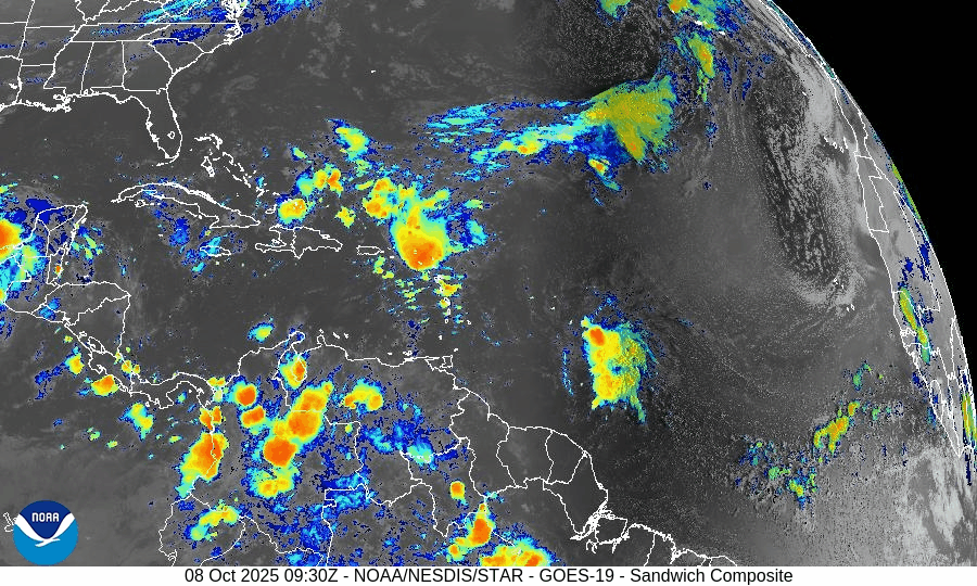
On October 8, Tropical Storm Jerry has formed from Invest 95L in the central Atlantic and continues to strengthen on its west-northwest path toward the Leeward Islands. The National Hurricane Center has also noted a weak disturbance in the Bay of Campeche with only a 10% chance of development. Jerry remains no threat to Florida or the U.S. mainland, though dangerous surf and rip currents may develop along the East Coast as the storm intensifies.

Tropical Storm Jerry strengthens; Gulf disturbance has low odds of development
Atlantic Basin Overview
Tropical Storm Jerry
The disturbance Invest 95L has now officially become Tropical Storm Jerry, located several hundred miles east-southeast of the northern Leeward Islands. Jerry continues its west-northwest track, and a tropical storm watch has been issued for parts of the northern Leeward Islands as the system is forecast to strengthen further.Gulf / Bay of Campeche Disturbance
A broad area of disorganized showers and thunderstorms persists over the Bay of Campeche. Some slow development is possible before the system moves inland over southern Mexico. However, the NHC currently assigns it only about a 10% chance of development over both the next 48 hours and 7 days.
Environmental Conditions
Sea Surface Temperatures (SSTs):
SSTs ahead of Jerry remain warm enough (around 28–29 °C) to support continued intensification.Wind Shear:
Jerry is in a region of moderate shear which may slow rapid strengthening. If it can consolidate its core, further intensification is possible.Humidity & Dry Air / SAL (Saharan Air Layer):
Dry air and dust from the Saharan Air Layer are present across parts of the eastern Atlantic, which could limit convective coverage in Jerry’s outer bands.
Gulf of America & Caribbean
The Gulf of America and Caribbean remain quiet. No organized tropical development is expected there at present, outside the low-chance Bay of Campeche disturbance.
Florida & Eastern U.S. Forecast
Florida and the U.S. East Coast are not currently under direct threat from Jerry. The storm is still far east, and its path is expected to curve north later. Coastal areas should continue to monitor swells, surf, and rip currents as Jerry intensifies and pushes ocean energy westward.
Rain forecast visualization courtesy of Windy.com

TL;DR – October 8 Snapshot
Jerry is now a tropical storm, moving WNW toward the Leeward Islands with strengthening likely.
Bay of Campeche disturbance has low development chance (~10%).
Warm SSTs favor Jerry; shear and dry air could limit growth.
Gulf and Caribbean quiet otherwise.
Florida/Eastern U.S.: no land threat, but marine impacts (surf/rip currents) remain.