

Atlantic Hurricane Outlook – September 24, 2025
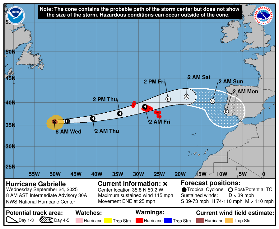
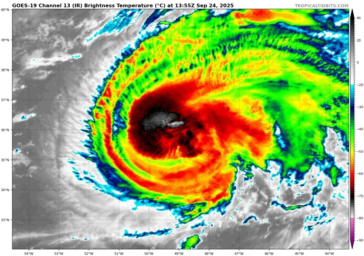
On September 24, Hurricane Gabrielle is a powerful Category 3 storm moving east-northeast toward the Azores, where a hurricane warning is in effect. While no direct landfall is expected in the U.S., Gabrielle’s swells are producing dangerous surf and rip currents along the East Coast. Other Atlantic disturbances remain suppressed by wind shear, dry air, and Saharan dust. Florida and the Gulf of America remain calm, experiencing only late-summer heat, humidity, and afternoon thunderstorms.

Gabrielle weakens slightly but remains a major hurricane as it approaches the Azores; East Coast seas stay rough
Atlantic Basin Overview
Hurricane Gabrielle
Gabrielle is now a Category 3 hurricane with maximum sustained winds near 115 mph. It is centered at 35.8° N, 50.2° W, moving east-northeast at about 25 mph. The storm is expected to weaken gradually as it encounters cooler waters, but it remains dangerous. A hurricane warning is in effect for the Azores, where Gabrielle will pass over or very near the islands late Thursday into Friday.Swells from Gabrielle continue to spread westward, producing life-threatening surf and rip currents across Bermuda, the U.S. East Coast from the Carolinas through New England, and into Atlantic Canada.
Other Waves / Disturbances
The NHC is monitoring additional tropical waves across the Atlantic. None are currently well-organized, and environmental conditions are limiting immediate development. Forecast guidance suggests these waves are not a threat to the Eastern U.S. coastline in the near term.


Environmental Conditions
Sea Surface Temperatures (SSTs): SSTs beneath Gabrielle remain warm enough to support a major hurricane, but cooler waters lie ahead along its northeastward track, which will drive weakening in the coming days.
Wind Shear: Vertical wind shear is beginning to increase, disrupting Gabrielle’s inner core and capping further rapid strengthening. The eastern Atlantic waves are also encountering moderate to high shear, preventing better organization.
Humidity & Dry Air (SAL): Pockets of mid-level dry air and dust from the Saharan Air Layer are feeding into parts of Gabrielle’s circulation and heavily suppressing convection for the monitored waves farther east. This continues to be a key factor in limiting new development.
Gulf of America & Caribbean
The Gulf of America and Caribbean remain quiet, with no signs of tropical organization. Only routine late-September showers and thunderstorms are expected.
Florida & Eastern U.S. Forecast
Florida faces no direct tropical threats. The broader Eastern U.S. coastline is not in Gabrielle’s path, but dangerous surf and rip currents will continue along Atlantic beaches this week. Florida itself remains in a late-summer pattern of hot, humid conditions with scattered afternoon thunderstorms.
Dust data courtesy of Windy.com

Summary
Gabrielle is a Category 3 hurricane, expected to weaken as it nears the Azores.
The storm is producing hazardous swells and rip currents across the Western Atlantic, including along the U.S. East Coast.
Environmental factors: warm SSTs still support Gabrielle, but increasing shear, cooler waters, and SAL-driven dry air are forcing gradual weakening.
The Gulf of America, Caribbean, Florida, and Eastern Seaboard remain free of direct tropical threats, aside from marine hazards.
TL;DR – September 24 Snapshot
Gabrielle: still a powerful Cat 3, moving toward the Azores.
Dangerous surf/rip currents along the East Coast.
Other Atlantic waves remain weak; no U.S. land threats.
Environmental factors shifting toward weakening: cooler SSTs, higher shear, dry air.
Florida & Gulf stay calm aside from routine storms.

Atlantic Hurricane Outlook – September 15, 2025
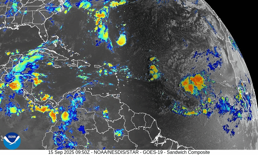
On September 15, the Atlantic remains without active storms, but attention is on a tropical wave in the central Atlantic. The National Hurricane Center gives it a 30% chance of development in 48 hours and 80% over 7 days. Warm waters and easing wind shear may support gradual organization, while dry air and Saharan dust continue to limit rapid strengthening. Florida and the Gulf remain calm, with only routine heat, humidity, and scattered thunderstorms.

Quiet Atlantic continues; a tropical wave off western Africa showing high 7-day development potential
Atlantic Basin Overview
No Active Tropical Cyclones
The Atlantic, Gulf of Mexico, and Caribbean remain storm-free. The National Hurricane Center confirms there are no tropical storms or hurricanes currently active.Tropical Wave in the Central Tropical Atlantic
A tropical wave located in the central tropical Atlantic is producing a large area of disorganized showers and thunderstorms. It is moving west-northwest at 10-15 mph, and environmental conditions are expected to permit gradual development through the week. Formation chances are about 30% over the next 48 hours, increasing to 80% over the next 7 days.
Environmental Conditions
Sea Surface Temperatures (SSTs): SSTs in the tropical Atlantic remain warm enough to support storm formation.
Wind Shear: Moderate shear is present; while it may hinder rapid intensification early on, shear is expected to diminish somewhat near the wave’s path.
Dry Air & Saharan Air Layer (SAL): Dry air and some SAL/ dust intrusions are observed over parts of the eastern Atlantic. These will likely slow initial development but are not expected to completely prevent it as moisture pickup increases.
Gulf of America (Mexico) & Caribbean
The Gulf remains quiet under high pressure. Only routine afternoon and marginal overnight thunderstorms are forecast along coastal zones. No systems are showing organization or threat. Seas are generally modest.
Florida & Southeast U.S. Forecast
Florida is continuing its typical mid-September pattern: hot, humid, with scattered afternoon storms driven by sea breezes. With no tropical systems nearby, there are no tropical threats expected this week. Marine conditions are moderate and normal for this time of year.
Rain forecast visualization courtesy of Windy.com

Summary
The Atlantic remains calm with no active storms.
A tropical wave in the central Atlantic shows high potential (80% over 7 days) to develop, possibly forming a depression by week’s end.
Environmental factors (warm SSTs, reducing shear, some dry air) are mixed—some favorable, some limiting.
Gulf, Caribbean, Florida remain quiet with routine weather patterns.
TL;DR – September 15 Snapshot
Atlantic is quiet; no active systems.
The central tropical Atlantic wave has ~80% 7-day development odds.
Conditions are marginal but becoming more favorable near the wave.
Florida/Gulf remains calm with only the usual summer storms.

Atlantic Hurricane Outlook – September 2, 2025
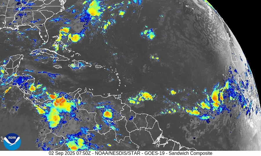
On September 2, the Atlantic remains storm-free with no active tropical cyclones. A tropical wave emerging off the coast of Africa shows rising organization and carries a 70% chance of development within 7 days. Environmental conditions are gradually improving, though dry air and Saharan dust remain factors. The Gulf of Mexico and Florida stay calm with only typical early-September thunderstorms.

TLDR Version: Click Here
Atlantic remains quiet; African wave gaining strength with a 70% 7-day development chance
Atlantic Basin Overview
No Active Storms
The Atlantic basin remains clear of any active tropical cyclones.Tropical Wave Emerging off Africa
A tropical wave located south of the Cabo Verde Islands is showing signs of organization. Environmental conditions are becoming more favorable, prompting a forecast of a low 30% chance of formation in the next 48 hours, rising significantly to a high 70% chance of development over the next 7 days.
Environmental Conditions
Sea Surface Temperatures (SSTs): Remain warm (~29–31 °C) in the Caribbean and Gulf, supportive for tropical development. Cooler conditions persist in the open Atlantic.
Wind Shear: Moderate to strong across much of the Atlantic; however, shear is forecast to ease gradually across the eastern tropical Atlantic, aiding organization of the wave.
Mid-Level Humidity & SAL: While dry air and Saharan Dust (SAL) remain present, pockets of increasing moisture near the African wave are aiding its potential development.
Gulf of America (Mexico) & Caribbean
The Gulf remains quiet, dominated by high pressure. Expect only daily sea-breeze afternoon thunderstorms—no tropical development is anticipated.
Florida & Southeast U.S. Forecast
Florida continues with typical early-September weather—hot, humid, and prone to scattered afternoon thunderstorms. There are no tropical threats or coastal hazards affecting the state at this time.
Rain forecast visualization courtesy of Windy.com
Summary

Atlantic basin remains calm, but one African wave shows high development potential (70%) over 7 days.
Environmental factors including SSTs, shear, moisture, and SAL will determine whether it organizes.
Gulf and Florida experience routine late-summer weather; no tropical systems in the near term.
TL;DR – September 2 Snapshot
Atlantic quiet with no storms.
70% chance a wave near Africa develops in the next 7 days.
Warm SSTs but competing shear and dry air—watch environment closely.
Florida and Gulf remain in standard summer pattern.