
Atlantic Hurricane Outlook – October 16, 2025
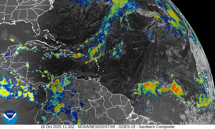
On October 16, Tropical Storm Lorenzo continues to weaken while tracking northeast over the central Atlantic with winds around 40 mph. Increasing wind shear, cooler waters, and dry air are causing the system to lose strength. No other tropical development is expected across the basin, and Florida and the Gulf of America remain quiet aside from minor marine swells and rip current risks.

Tropical Storm Lorenzo continues weakening over open waters; no new systems developing
Atlantic Basin Overview
Tropical Storm Lorenzo
Lorenzo is weakening while maintaining a general north to northeast track over the central Atlantic. Lorenzo has maximum sustained winds of about 40 mph, with tropical-storm-force winds extending outward roughly 60 miles from the center.
Lorenzo will shift toward the northeast later in the week and gradually dissipate, with no landfall expected.Other Tropical Activity
There are currently no other active tropical cyclones in the Atlantic, Caribbean, or Gulf basins. The NHC’s 7-day outlook indicates no additional tropical cyclone formation expected in that timeframe.
Environmental Conditions
Sea Surface Temperatures (SSTs):
Lorenzo is traversing moderately warm waters supportive of tropical structure, though as it moves northward it will encounter cooler SSTs that accelerate decay.Wind Shear:
The system continues to face moderate to strong vertical wind shear, which is limiting deep convection and contributing to its weakening trend.Dry Air / SAL (Saharan Air Layer):
Surrounding dry air and intrusions of dust remain factors, suppressing convection in outer bands and preventing reintensification.
Gulf of America & Caribbean
As of now, the Gulf of America and Caribbean remain quiet, with no organized tropical systems developing. Routine seasonal convection (showers, storms) continues.
Florida & Eastern U.S. Forecast
No tropical threats are forecast for Florida or the U.S. East Coast, as Lorenzo stays well offshore. The main impact to watch is marine hazards: lingering swells, rough surf, and rip currents along Atlantic beaches may continue through the period.
Rain forecast visualization courtesy of Windy.com

TL;DR – October 16 Snapshot
Lorenzo has weakened to ~40 mph and is heading northeast over open water.
No new tropical systems are being tracked.
Environmental conditions—shear, cooler SSTs, dry air—are eroding Lorenzo’s structure.
Gulf, Caribbean, Florida remain calm.
Coastal marine hazards remain the primary concern.
Atlantic Hurricane Outlook – October 13, 2025
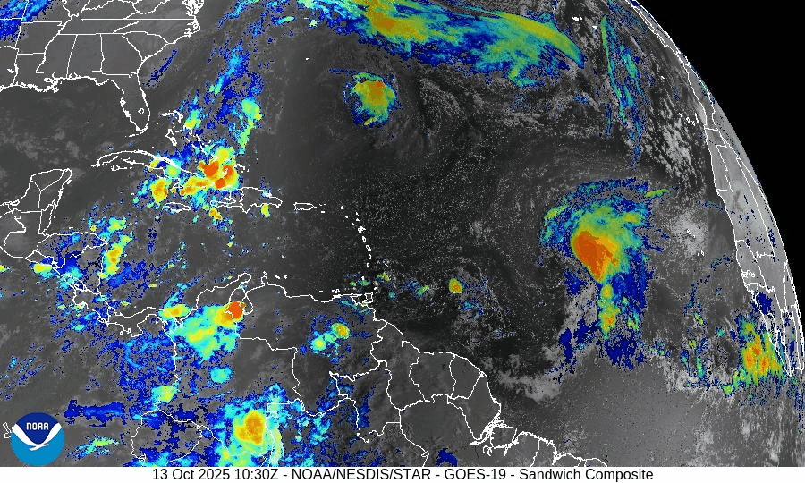
On October 13, Tropical Storm Lorenzo formed in the central Atlantic with maximum winds near 45 mph and favorable conditions for further development. The system is expected to strengthen steadily as it moves west-northwest over warm 29–30°C waters. Meanwhile, post-tropical Jerry continues east of Bermuda, and Florida remains clear of tropical threats aside from elevated surf along the Atlantic coast.

Tropical Storm Lorenzo forms in the central Atlantic; Jerry now post-tropical east of Bermuda
Atlantic Basin Overview
Tropical Storm Lorenzo (formerly Invest 97L)
The National Hurricane Center has officially designated Tropical Storm Lorenzo (AL17) in the central tropical Atlantic, located near 12°N, 38°W, or roughly 900 miles southwest of the Cabo Verde Islands.
Lorenzo is moving west-northwest at around 15 mph, with maximum sustained winds near 45 mph and minimum central pressure near 1005 mb.Organization has improved significantly over the past 24 hours, with persistent convection consolidating around a developing center. The storm’s cloud structure shows banding features and outflow beginning to improve on its western flank.
Forecast & Track:
Lorenzo is expected to continue moving west-northwest for the next several days, gradually turning more northwest by midweek under the influence of a mid-level ridge.
Environmental conditions—warm sea surface temperatures (29–30°C), ample mid-level moisture, and low vertical wind shear (10–15 kt)—favor steady strengthening, and Lorenzo could become a hurricane by Wednesday or Thursday if current trends continue.Model guidance (ECMWF, GFS, and HWRF ensembles) indicates Lorenzo will likely remain over open waters through the week, though some long-range uncertainty remains regarding a possible westward bend late in the period.
Post-Tropical Jerry (east of Bermuda)
The remnants of Tropical Storm Jerry are now an elongated trough east-southeast of Bermuda. Gale-force winds (35–40 kt) persist along the northern edge, but the system lacks tropical characteristics and is not expected to redevelop. Seas near the trough remain 10–14 feet, gradually subsiding through Tuesday.Subtropical Storm Karen (north Atlantic)
Karen continues to weaken over the far North Atlantic, with maximum winds near 40 mph. The system is expected to lose its subtropical structure and dissipate within 24 hours over cold waters.
Environmental Conditions
Sea Surface Temperatures (SSTs):
SSTs across Lorenzo’s path remain well above average (29–30°C) — highly favorable for sustained deep convection and intensification.Wind Shear:
Current shear is low to moderate (10–15 kt) in the central Atlantic, allowing Lorenzo to organize further. Slight increases in shear may occur later this week as the storm tracks northwest.Humidity & Dry Air / SAL:
The Saharan Air Layer remains present north and east of Lorenzo but has receded sufficiently to the northeast. Moisture surrounding the storm’s core is increasing, limiting dry air intrusion and supporting vertical growth.
Gulf of America & Caribbean
The Gulf of America and Caribbean remain quiet. No tropical development is expected in these regions through at least the next 5–7 days. Afternoon convection and sea-breeze thunderstorms continue as typical for October.
Florida & Eastern U.S. Forecast
There are no immediate tropical threats to Florida or the U.S. East Coast. Lorenzo is far out in the central Atlantic, and current steering patterns favor a northwest track away from land.
Residual swell energy from past systems, combined with seasonal transitions, will continue to produce high surf and rip current risks along the Southeast and Mid-Atlantic beaches.
Otherwise, Florida remains under typical early-fall conditions—warm, humid afternoons with isolated sea-breeze storms.
Rain forecast visualization courtesy of Windy.com

TL;DR – October 13 Snapshot
Tropical Storm Lorenzo (AL17) has officially formed in the central Atlantic, moving WNW with 45 mph winds.
Favorable conditions (warm SSTs, low shear, and increasing moisture) support strengthening—could reach hurricane strength midweek.
Post-tropical Jerry continues east of Bermuda with lingering gales.
Karen dissipating in the North Atlantic.
No tropical threats to Florida or the U.S. mainland at this time.
Marine impacts (swells, rip currents) remain the primary concern along Atlantic beaches.