
Atlantic Hurricane Outlook – September 13, 2025
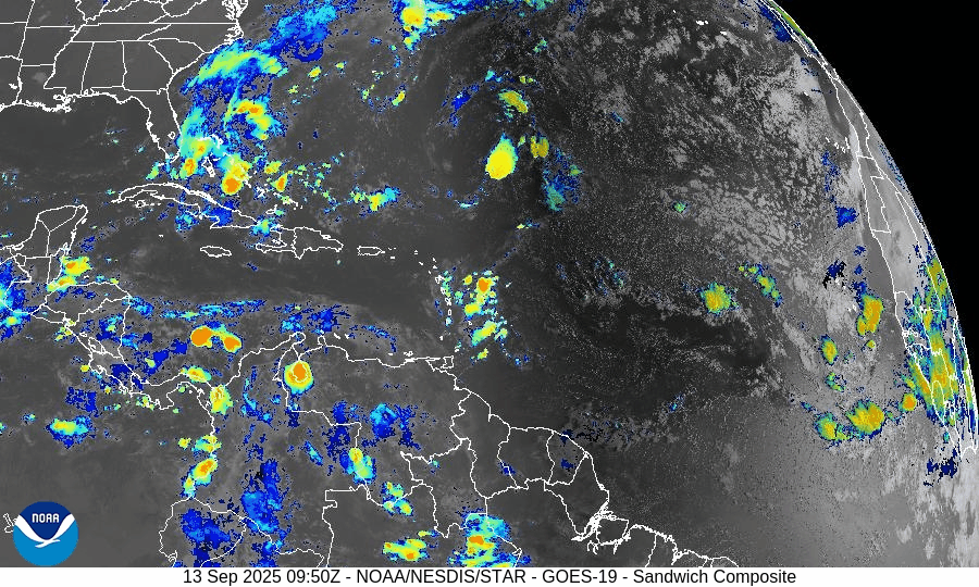
On September 13, the Atlantic basin remains storm-free, with no tropical cyclones currently active. A tropical wave between Africa and the Cabo Verde Islands is producing showers and thunderstorms but faces limited short-term development potential due to dry air and wind shear. The Gulf of Mexico and Florida remain calm, experiencing only the usual heat, humidity, and afternoon storms of late summer.

Atlantic basin quiet; tropical wave off Africa flagged, but development odds remain modest
Atlantic Basin Overview
No Active Tropical Cyclones
There are currently no tropical storms, hurricanes, or depressions in the Atlantic, Gulf of Mexico, or Caribbean. The NHC confirms the basin is calm with no active systems.Tropical Wave Near Africa / Cabo Verde Islands
A tropical wave located between the west coast of Africa and the Cabo Verde Islands is producing some showers and thunderstorms. It’s being monitored. Environmental conditions (dry, stable air) are expected to limit development over the next few days, though a tropical depression could form by the middle to latter part of next week, moving west-northwestward at ~10-15 mph.
Environmental Conditions
Sea Surface Temperatures (SSTs): Warm in the Caribbean and Gulf (~29–31 °C), but the far eastern Atlantic faces somewhat cooler and less supportive SSTs for strong development.
Wind Shear: Moderate to strong upper-level wind shear persists, especially over the regions east of the tropical wave, making rapid intensification unlikely.
Dry Air & Saharan Air Layer (SAL): Significant dry and stable air, partly from the SAL, remains present over much of the eastern and central Atlantic — this is suppressing convective organization in the tropical wave.
Gulf of (America) Mexico & Caribbean
Both regions remain calm under high pressure. Only typical afternoon sea-breeze thunderstorms are occurring. There are no disturbances showing signs of organization in the Gulf or Caribbean.
Florida & Southeast U.S. Forecast
Florida continues with late-summer conditions: hot, humid, with scattered afternoon showers and thunderstorms. With no nearby tropical systems, there are no tropical threats or enhanced coastal risks at this time. Marine conditions are benign.
Rain forecast visualization courtesy of Windy.com

Summary
Atlantic basin remains inactive; no active systems.
A tropical wave off Africa is being monitored; development is possible later in the week but odds are modest and hindered by dry air and shear.
Environmental conditions are generally unfavorable for strong or rapid development in the near term.
Gulf, Caribbean, and Florida see only routine seasonal weather—no tropical threats.
TL;DR – September 13 Snapshot
Atlantic quiet—no storms active.
Tropical wave near Africa has potential but low short-term chances.
Dry air, SAL, and shear continue to suppress activity.
Florida & Gulf remain calm, with typical heat and scattered storms.

Atlantic Hurricane Outlook – September 4, 2025
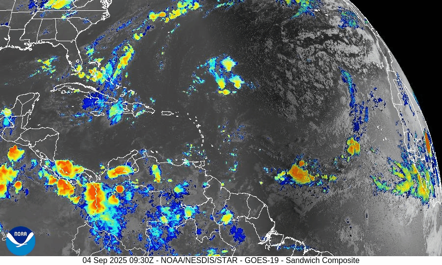
On September 4, the Atlantic basin remains quiet with no active storms. The main feature is a tropical wave west-southwest of Cabo Verde, showing signs of organization. The NHC gives it a 50% chance of becoming a tropical depression within 48 hours and 80% within 7 days. It is expected to move west to west-northwest and could approach the eastern Caribbean by mid-next week. The Gulf of Mexico and Florida remain calm, experiencing only typical summer thunderstorms.


TLDR Version: Click Here
Atlantic quiet overall; tropical wave WSW of Cabo Verde likely to become a depression this weekend
Atlantic Basin Overview
Eastern Atlantic disturbance (near 34°W)
Showers and storms tied to a tropical wave several hundred miles west-southwest of the Cabo Verde Islands are getting a bit better organized. The NHC says environmental conditions are conducive for development, and a tropical depression is likely late this week or this weekend as the wave moves W–WNW ~5–10 mph. It should accelerate westward afterward and reach waters east of the Lesser Antilles by mid-next week. Formation odds: 50% (48 hr) and 80% (7 days).
No other active systems
Aside from this wave, no tropical cyclones are active in the Atlantic this morning per NHC outlooks.
Environmental Conditions
Sea Surface Temperatures (SSTs): Warm waters persist across the deep tropics, with widespread warmth expected to favor development as the wave travels west. (NHC notes “conducive” conditions for this system.)
Wind Shear: Broad Atlantic shear has been on the higher side recently, but guidance and outlooks indicate a more favorable pocket near the wave, aligning with the NHC’s expectation of gradual organization.
Mid-level Humidity & SAL: Dry air/Saharan dust remain scattered across the central Atlantic and have been suppressing convection in other waves; conditions are less hostile near the developing disturbance than earlier this week.
Large-scale pattern: Forecasters expect upticks in Atlantic activity in early September given unusually warm waters and supportive intraseasonal signals; still, track confidence for any single wave is low at this lead time.
Gulf of American (Mexico) & Caribbean
The Gulf remains quiet under relatively benign marine conditions; no tropical development is indicated in current NHC products. Offshore forecasts keep light winds and low seas (generally ≤3 ft) through the period.
Florida & Southeast U.S. Forecast
General pattern: Hot, humid late-summer weather with the daily sea-breeze cycle of scattered afternoon thunderstorms continues. No tropical threats for the state are signalled by NHC at this time. (Central Florida forecast discussions also note a lingering boundary with showers/storms, trending a bit drier into the weekend.)
Rain forecast visualization courtesy of Windy.com

Summary
A tropical wave WSW of Cabo Verde has 50% (48 hr) / 80% (7-day) odds to form; a depression is likely late week/weekend as it tracks W–WNW.
No other active tropical cyclones in the Atlantic this morning.
Environment: warm SSTs and a somewhat improved shear/moisture backdrop near the wave support gradual development, but SAL/dry air remain pockets of resistance elsewhere.
Gulf and Florida: quiet from a tropical standpoint; typical afternoon storms, light marine winds, and low seas prevail.
TL;DR – September 4 Snapshot
High-confidence watch: Wave WSW of Cabo Verde likely to become a depression late week/weekend; 80% 7-day odds.
Track window: Guidance favors a west to west-northwest motion toward the east of the Lesser Antilles by mid-next week (too early for specifics).
No other systems active; Gulf & Florida remain in a routine summer pattern with scattered storms and no tropical threats.
