

Atlantic Hurricane Outlook – June 9, 2025: Tropical Tranquility Continues
No storms are expected this week as the Atlantic hurricane season stays quiet. Warm waters and shifting wind patterns suggest activity could increase later in June. Stay prepared with today’s full update.
The ninth day of the 2025 Atlantic hurricane season dawns with quiet conditions—no active storms or signs of tropical development are present. The National Hurricane Center (NHC) confirms that no tropical cyclone formation is expected in the Atlantic Basin over the next seven days. It's a typical early-June lull, but with warming waters and shifting atmospheric dynamics, conditions may change quickly.
Atlantic Basin: Clear Skies, No Areas of Concern
No active tropical cyclones
No disturbances or systems being monitored
7-day outlook shows no development expected
This continued calm aligns with seasonal norms—but forecasters are keeping a cautious eye on the evolving environment.
Satellite imagery courtesy of Windy.com
Sea Surface Temperatures: Warm and Watchful
Gulf of America (Mexico) & Western Caribbean: Sea surface temperatures remain in the low‑to‑mid‑80s °F (27–29 °C), sufficient to fuel tropical systems.
Main Development Region (MDR): SSTs are gradually rising, though not yet at peak summer levels.
These ongoing warm waters provide a key energy source for future storm formation.
Sea Surface Temperature (SST) data courtesy of Windy.com
Atmospheric Conditions: Still Mixed, Not Conducive
Wind Shear: Moderate to high shear persists, particularly in western Caribbean and central Atlantic—suppressing thunderstorm organization.
Moisture Levels: While mid-level atmospheric moisture is increasing, it's not yet sufficiently abundant or widespread to support cyclone development.
Together, these factors continue to limit tropical activity.
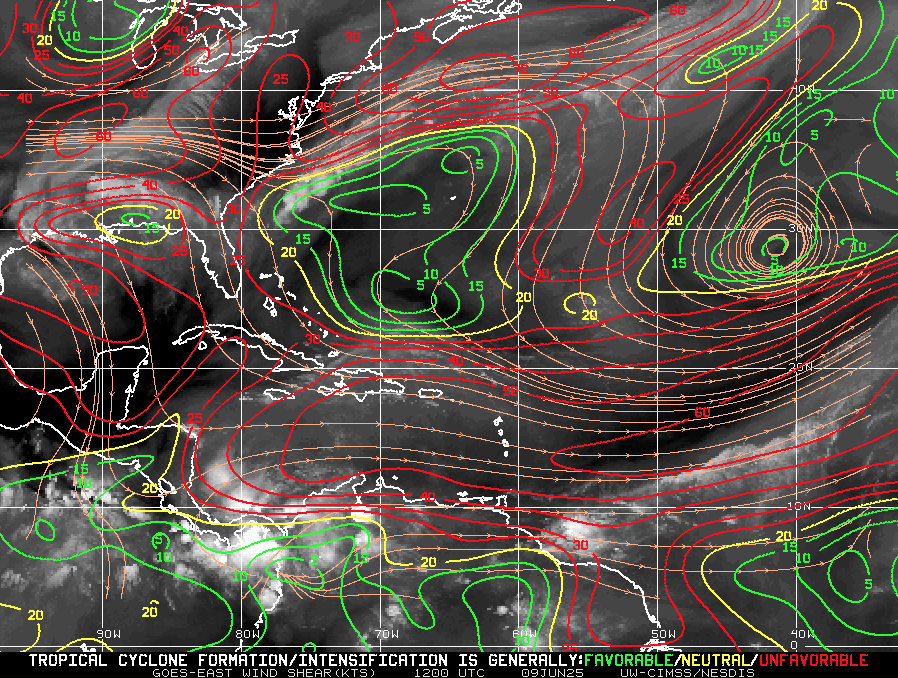
Wind Shear Courtesy of https://tropic.ssec.wisc.edu/
Saharan Air Layer: A Persistent Block
A strong plume of dry, dusty Saharan air remains entrenched over the central and eastern Atlantic.
This Saharan Air Layer (SAL) injects dryness and wind shear that further inhibit storm formation.
Expect suppression to continue into mid-June when SAL influence typically begins to decline fox35orlando.com.
Saharan Air Layer (Dust) data courtesy of Windy.com
Thunderstorm Activity: Routine, Non-Tropical
Florida & Southeast U.S.: Scattered afternoon storms—typical for early June.
Western Caribbean: A few isolated, disorganized cells persist, but show no signs of development.
Eastern Atlantic: Quiet and without organized convection.
These systems are seasonal and not related to hurricane development.
Thunderstorm data courtesy of Windy.com
Florida Forecast (All Regions)
Highs: Upper 80s to low 90s °F (31–33 °C)
Humidity: Moderate to high, creating a muggy atmosphere
Rain: Isolated to scattered afternoon and evening storms
Winds: Light and variable
A classic early-summer day with palm trees swaying but no storm threats.
Rainfall forecast courtesy of Windy.com
Prep Tip of the Day: Review Evacuation Plans
Use this calm window to double-check your evacuation readiness:
Reconfirm your evacuation zone and route.
Update your household emergency plan, including pets and special needs.
Keep contact numbers accessible, especially local officials and emergency services.
Test your NOAA weather radio and ensure alerts are activated on mobile devices.
Looking Ahead: Still Calm, But Eyes Remain Open
No tropical development is forecast this week, but the environment is slowly warming and becoming more favorable:
Warm water concentrations persist
Wind shear may decrease in the coming weeks
Moisture levels are increasing regionally
While it's still quiet, conditions are edging toward potential activity. Continue to check in daily for updates as Cat5Prep.com monitors the evolving season.