
Atlantic Hurricane Outlook – August 20, 2025: A Couple Systems In The Atlantic
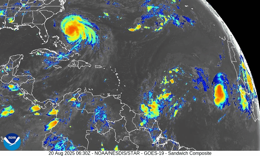
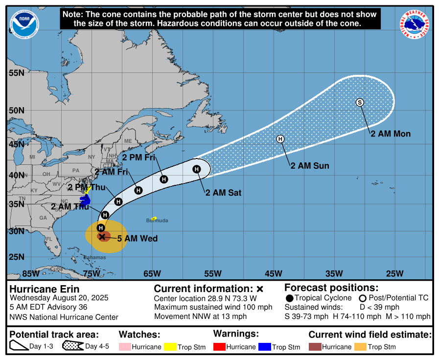
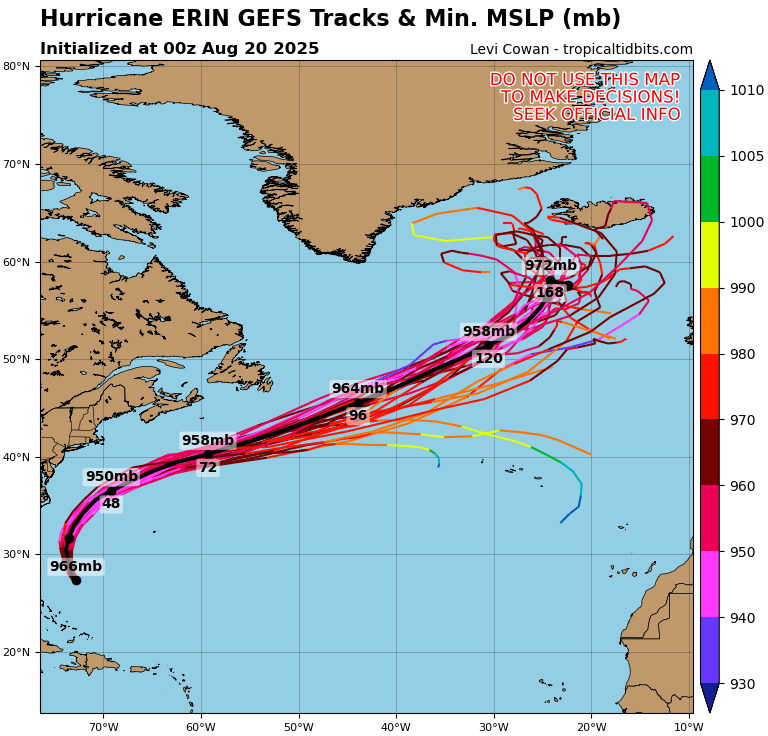
Hurricane Erin is holding as a Category 2 storm offshore, producing rip currents and coastal hazards along the East Coast. Meanwhile, the Gulf and Florida remain quiet, though tropical waves in the Atlantic are being monitored.
TLDR Version: Click Here
Current Tropical Systems

Hurricane Erin:
Erin has weakened slightly but remains a Category 2 hurricane as it tracks northeast, well offshore of the U.S. East Coast. The storm continues to generate dangerous swells, rip currents, and pockets of coastal flooding, especially from the Outer Banks northward into the Mid-Atlantic and New England. While direct landfall is not expected, coastal impacts remain significant.Disturbance in the Central Atlantic:
A tropical wave near 45°W continues to show signs of organization. Environmental conditions feature warm sea surface temperatures but are partially offset by moderate wind shear and Saharan Air Layer (SAL) dust intrusion. Development chances: 30% over 7 days.Far Eastern Atlantic Wave (off Africa):
A fresh wave near 25°W is emerging with scattered convection. It remains disorganized but will be monitored as it progresses westward. Development chances: low (20% over 7 days).


Gulf of America (Mexico) Outlook
The Gulf remains broadly quiet, with high pressure dominating and keeping conditions mostly stable. While moisture pockets are leading to afternoon thunderstorms, there are no signs of tropical development at this time. Sea surface temperatures are very warm (29–31°C), so the region will continue to be monitored closely heading into late August.
Florida Forecast
Florida remains under the influence of high humidity and afternoon sea-breeze thunderstorms, typical for August. Outer rainbands from Erin are not expected to impact the peninsula. No immediate tropical threats are forecast for the state in the near term.
Rain forecast visualization courtesy of Windy.com
Key Environmental Factors
Sea Surface Temperatures (SSTs): 29–31°C across the Gulf and Caribbean, MDR slightly above average — supportive for development.
Wind Shear: Moderate over the central Atlantic, helping limit wave organization.
Moisture: Gradual increase in the western Atlantic, but SAL dust continues to suppress deep convection in parts of the MDR.

Outlook Summary
Hurricane Erin remains a strong offshore system, generating significant surf and rip currents along the East Coast.
Central Atlantic disturbance carries moderate development potential but faces shear and dust challenges.
Gulf of Mexico and Florida remain calm with no immediate tropical concerns, though warm waters warrant close monitoring later this month.
TL;DR
Hurricane Erin is now a Category 2 offshore system, still driving dangerous surf and rip currents up the East Coast. The Gulf of Mexico and Florida stay quiet with only scattered thunderstorms, while the central Atlantic wave shows some development potential but is being held back by wind shear and Saharan dust.
Atlantic Hurricane Outlook – August 3, 2025: Two Areas Now Under Watch
The Atlantic remains calm with no named storms, but two areas—one off the U.S. coast and another off Africa—are now under watch for potential tropical development. Here's today's scientific hurricane outlook.
*Those who like data, continue reading. Those it prefer the quick version, jump to the TL;DR here.
As early August continues, the Atlantic remains without any active tropical cyclones. However, two areas have emerged as brown disturbance watches, as forecasters monitor subtle signs that could impact the Atlantic if conditions shift.
Atlantic Basin Highlights
No active tropical storms in the basin.
Two areas are now under National Hurricane Center scrutiny:
Invest Area AL95: Expected to be a fish storm, it’s a non-tropical low just off the North Carolina coast—producing disorganized thunderstorms. (The orange X on the chart)
➤ Chance of development: Medium (30%) over the next 2–7 days.
➤ Movement: Toward the east-northeast at ~10 mph, expected to stay offshore.Emerging tropical wave off Africa: Near 30°W, forecast to move westward with scattered convection.
➤ Chance of development: Low (30%) within 7 days.
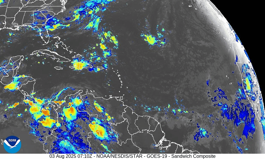
GOES-19 - Sector view: North Atlantic - Sandwich - August 3, 2025
GOES-19 - Sector view: Tropical Atlantic - Sandwich - August 3, 2025
Key Environmental Conditions
Sea Surface Temperatures (SSTs):
The Gulf of Mexico and Caribbean Sea remain very warm, with temperatures ranging from 29–31°C (84–88°F). The Main Development Region (MDR) is also running slightly above average. These warm waters provide abundant fuel for tropical development — if other atmospheric factors allow.Wind Shear:
Moderate to high vertical wind shear persists across the central Atlantic, particularly along the latitude band where Disturbance 2 is located. This disrupts the vertical alignment of developing systems and limits the ability of convection to consolidate around a center.Moisture:
Mid-level moisture is gradually increasing across the western tropical Atlantic and Caribbean. However, the central Atlantic remains drier overall, especially in areas affected by Saharan dust, limiting deep convection and thunderstorm persistence.Saharan Air Layer (SAL):
A robust SAL is sweeping across the central and eastern Atlantic, characterized by dry, dusty air and suppressed vertical motion. The SAL also contributes to a stable atmosphere, effectively capping thunderstorm development and working against tropical wave organization.
Implication for Disturbance 2:
While ocean temperatures are favorable, the combined influence of high wind shear, limited moisture, and widespread SAL intrusion is expected to stall or inhibit further development of Disturbance 2 as it continues westward across the tropical Atlantic. Until it reaches a more favorable environment, organization remains unlikely.
Gulf of America (Mexico) & Caribbean Region
No disturbances active in the Gulf, and high-pressure conditions support light winds and minimal rain outside normal sea‑breeze showers.
Eastern Caribbean: A wave near 68°W is producing localized storms over Hispaniola and Venezuela but remains disorganized.
GOES-19 - Sector view: Gulf of America - Sandwich - August 3, 2025
GOES-19 - Sector view: Caribbean - Sandwich - August 3, 2025
Florida Weather Outlook
Highs: Near 90 °F under sticky, humid conditions.
Conditions: Scattered afternoon thunderstorms from sea breeze interactions.
No tropical impacts expected today.
Rain forecast visualization courtesy of Windy.com
Prep Tip of the Day: Know Your Warning Signals
Test your alert systems today:
Confirm subscription to NOAA alerts and local county emergency systems.
Test NOAA weather radios and storm tracker apps.
Make sure household members know hurricane communication plans and locations of essential documents.
Outlooking Ahead
Invest Area AL95, while moving away from land, bears watching if it gains tropical characteristics. Meanwhile, the wave off Africa will pass into warmer waters—another early‑August indicator. Meteorological models forecast these systems might strengthen if wind shear declines and dust regresses later this month.
TL;DR – August 3 Hurricane Summary
No storms currently in the Atlantic basin.
AL95 (off North Carolina): 30% chance of development over the next week. (Fish Storm)
African wave near 30°W: 20% chance of development within 7 days.
Factors are currently favoring disorganization.
SSTs are warm and moisture is increasing—conditions may improve in early August.
Immediate risk remains low; now is a good window for storm preparedness.
Stay alert and ready with daily forecasts at Cat5Prep.com.

Atlantic Hurricane Outlook – July 30, 2025: Development Chances Remain Low
As July ends, the Atlantic Basin sees active tropical waves, but development chances remain low for the next 7 days. Discover the latest on sea surface temperatures, wind shear, Saharan Air Layer, and the outlook from CAT5Prep.com.
*Those who like data, continue reading. Those it prefer the quick version, jump to the TL;DR here.
** Due to technical issues on the GOES satellite imagery provider's end, we are currently unable to display real-time satellite imagery.
The Atlantic Basin remains active with multiple tropical waves stretching from the African coast to the Caribbean, yet no organized development is expected in the near term. Wind shear and Saharan dust continue to suppress cyclone formation despite warm ocean temperatures and a moistening atmosphere in the western basin.
As we close out July, conditions are slowly trending toward a more favorable setup for storm development heading into August.
Atlantic Basin Overview
As of the 8:00 AM EDT NHC Tropical Weather Outlook:
No active tropical cyclones.
Three tropical waves span the Atlantic:
Wave near 35°W (eastern Atlantic): Disorganized, little convection.
Wave near 50°W (central Atlantic): Producing scattered thunderstorms, no surface low.
Wave in the eastern Caribbean: Weak and encountering dry air and shear.
NHC Development Odds:
Next 48 hours: 0%
Next 7 days: 0%
Key Environmental Factors
SST data courtesy of Windy.com
Wind data at 850hPa from Windy.com
Sea Surface Temperatures (SSTs):
29–31°C (84–88°F) in the Gulf of Mexico and Caribbean.
MDR remains slightly warmer than normal.
Wind Shear:
Moderate across the central Atlantic and Caribbean.
Suppressing vertical development for now.
Saharan Air Layer (SAL):
Strong dry air across much of the basin.
Limiting convection and keeping tropical waves disorganized.
Moisture:
Gradually increasing in the western Atlantic and Caribbean.
A factor to monitor as wind shear begins to ease.
Gulf of Mexico (Gulf of America)
A weak surface trough in the central Gulf is producing scattered showers and isolated thunderstorms.
No signs of organization, and the NHC does not expect development at this time.
High pressure remains dominant elsewhere, with calm conditions expected through midweek.
Florida Weather
Highs in the upper 80s to low 90s with high humidity.
Scattered thunderstorms possible in the afternoon and evening from sea breeze interactions.
No tropical threats to Florida at this time.
Radar imagery courtesy of Windy.com
Outlook & Preparedness
The Atlantic remains broadly quiet for now, but the environment is slowly shifting. A steady wave train emerging off Africa and increasingly favorable SSTs point to a more active window in early to mid-August.
Now is the time to double-check hurricane kits, review evacuation zones, and prepare while the weather allows.
TL;DR – July 30 Snapshot
No tropical development expected this week.
Three tropical waves are present but remain weak and disorganized.
SAL and shear are limiting development.
Conditions should become more favorable by early August.