
Atlantic Hurricane Outlook – October 2, 2025
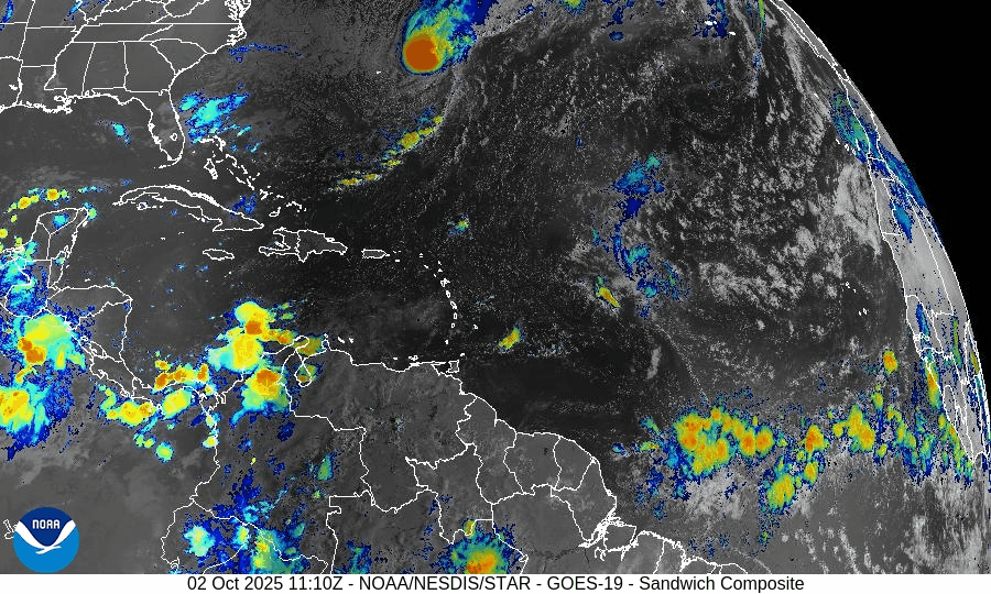
On October 2, Hurricane Imelda has weakened to Category 1 while racing east-northeast away from Bermuda after bringing damaging winds and power outages to the island. Humberto has transitioned into an extratropical system, but swells and rip currents will persist along the U.S. East Coast. Environmental factors—cooler waters, rising wind shear, and Saharan dust—are driving Imelda’s decline and limiting new development. Florida and the Gulf of America remain quiet.

Imelda weaker but still impactful; Humberto dissipates; hazardous marine conditions persist
Atlantic Basin Overview
Hurricane Imelda
Imelda passed near Bermuda, causing widespread power outages, downed trees, and strong winds. It has since weakened to Category 1 status with sustained winds near 80 mph and is moving east-northeast at 30 mph. No U.S. landfall is expected as Imelda continues to track away.Hurricane Humberto
Humberto has merged with frontal systems and lost tropical characteristics, transitioning into an extratropical cyclone. Its circulation is no longer classified as a hurricane, though its remnant energy continues contributing to swells and marine hazards along the Atlantic.Other Disturbances / Waves
Additional Atlantic waves are being watched, but none currently show robust development or trajectories toward U.S. coasts under present forecasts.
Environmental Conditions
Sea Surface Temperatures (SSTs):
SSTs near Imelda and Bermuda remain warm enough to support tropical cyclone strength, but cooler waters lie ahead along its projected path, which will continue to weaken it.Wind Shear:
Vertical wind shear is increasing across Imelda’s circulation, eroding convection and weakening structural organization.Humidity & Dry Air / SAL:
Dry mid-level air and dust from the Saharan Air Layer are penetrating outer bands and suppressing convection, especially in weaker waves farther east. These factors continue to restrict new storm development.
Gulf of America & Caribbean
The Gulf of America and Caribbean remain quiet, with no organized tropical systems. Shower and thunderstorm activity is typical for early October, but no tropical threats are present.
Florida & Eastern U.S. Forecast
Florida and the Southeast U.S. are not expected to see a tropical landfall from Imelda. However, the East Coast continues to experience dangerous surf, strong rip currents, and elevated coastal flooding potential, driven by Imelda and Humberto’s residual swell energy.
Rain forecast visualization courtesy of Windy.com

TL;DR – October 2 Snapshot
Imelda is now a Category 1 hurricane, weakening as it moves away from Bermuda.
Humberto has lost its tropical nature and is now extratropical.
Warm SSTs support Imelda, but increasing shear and dry air accelerate weakening.
Gulf of America and Caribbean remain calm.
U.S. East Coast should continue monitoring marine conditions—surf and rip currents remain the main hazard.
