
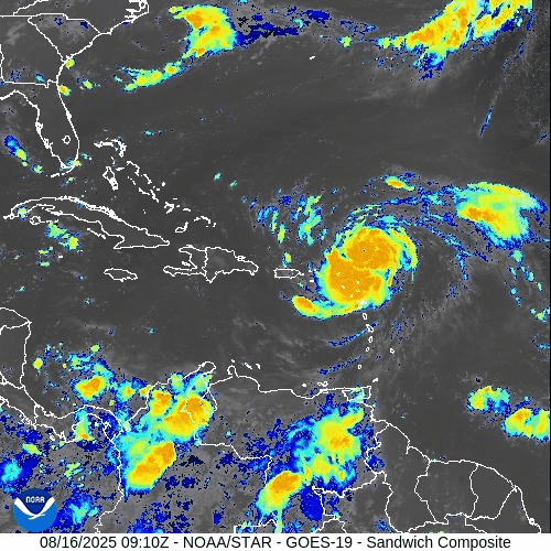
Atlantic Hurricane Outlook – August 16, 2025: Erin intensifies over the central Atlantic
Hurricane Erin has intensified over the central Atlantic while a weak Gulf disturbance delivers rain to South Texas and NE Mexico. Florida sees typical summer storms, with rising rip-current risks along Atlantic beaches as Erin’s swells arrive.
TLDR Version; Click Here

Erin intensifies over the central Atlantic; weak Gulf disturbance keeps rain focused on far South Texas and NE Mexico; U.S. impacts mainly marine
Hurricane Erin has strengthened over the central tropical Atlantic and remains on a track that keeps it well offshore of the U.S. mainland. In the Gulf of Mexico, a weak, broad low near the Bay of Campeche continues to funnel tropical moisture into far South Texas and northeastern Mexico, with low odds of tropical development. For most U.S. coastlines, the primary near-term impacts are building surf and an elevated rip-current risk as Erin’s long-period swells arrive.
Atlantic Basin Overview
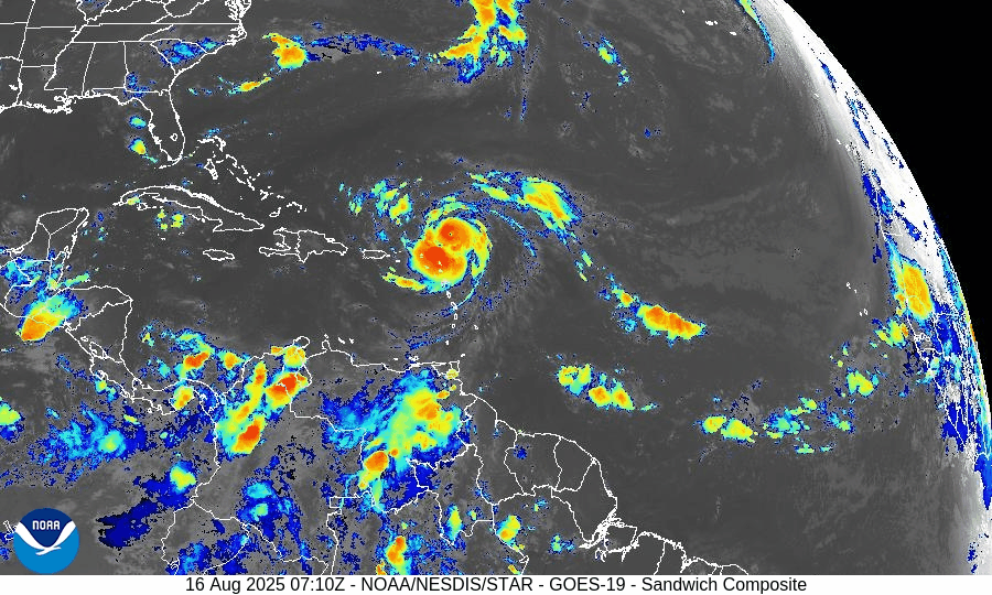
Hurricane Erin (central Atlantic): Erin has intensified into a major hurricane over very warm waters with supportive upper-level ventilation. Forecast guidance continues to favor a gradual bend to the northwest and then north this weekend into early next week, keeping the core well away from the Bahamas and U.S. East Coast. Even with an offshore track, long-period swells will propagate toward the Western Atlantic shorelines, bringing hazardous surf and rip currents ahead of any weather changes locally.
Elsewhere in the basin: A typical mid-August “wave train” extends from Africa across the Main Development Region (MDR). Most waves are battling pockets of dry air/Saharan dust and intermittent mid- to upper-level shear, limiting organization in the short term.


Gulf of America (Mexico) & Caribbean
Southwest Gulf disturbance (Bay of Campeche): A broad trough/weak low continues to drift west-northwest toward northeastern Mexico. Organization is limited; development odds remain low. Regardless of development, expect periods of heavy rain, locally gusty squalls, and choppy seas from the lower Texas coast southward into Tamaulipas/Veracruz.
Rest of the Gulf: Typical summer regime with scattered sea-breeze thunderstorms near the margins; light to moderate onshore flow most areas, with evening pulses of fresh easterlies along the Yucatán coast.
Caribbean Sea: Fresh trades continue in the south-central Caribbean with passing showers; no organized tropical systems at this time.
Florida & Southeast U.S. Outlook
Florida (statewide): A classic August pattern—hot, humid, and scattered to numerous afternoon thunderstorms driven by sea-breeze collisions and outflow boundaries. Storms are not tropical in origin but can produce frequent lightning, brief torrential rain, and localized gusty winds.
Atlantic beaches (FL/GA/SC/NC): Expect a rising rip-current risk and building surf through the weekend into early next week as Erin’s swells arrive. Check local beach forecasts and heed lifeguard guidance.
Gulf beaches (FL Panhandle/West FL): Typical late-day storms; rip-current risk mainly tied to local winds and storm outflows rather than distant swell.
Rain forecast visualization courtesy of Windy.com
Environmental Setup (Why/Why Not Development)
Sea Surface Temperatures: MDR, Caribbean, and Gulf waters are well above seasonal averages, supplying ample oceanic heat content (fuel) for systems that find a favorable atmospheric window.
Wind Shear: Shear is comparatively lower along Erin’s corridor (supporting its intensification) but patchy and occasionally moderate to high elsewhere—enough to disrupt other waves.
Moisture & SAL: Mid-level moisture is increasing west of ~45–50°W, but Saharan Air Layer intrusions still clip portions of the eastern/central MDR, injecting dry air and capping convection for several waves.
Preparedness Note

Even when a hurricane stays far offshore, its swells can be dangerous. If you’re heading to the beach, swim near lifeguards, avoid jetties/inlets during high surf, and review local rip-current statements. For Gulf communities under heavy rain today, avoid flooded roadways and allow extra travel time.
TL;DR – August 16 Snapshot
Erin is a major hurricane over the central Atlantic; expected to turn north and remain offshore of the U.S.
Bay of Campeche disturbance: Low development odds; brings heavy rain to far South Texas and NE Mexico.
Florida & Southeast: Typical hot, stormy afternoons; rip-current risk rising on Atlantic beaches from Erin’s distant swells.
Overall Atlantic remains active with waves, but shear and dry air are limiting most systems—for now.

Atlantic Hurricane Outlook – July 23, 2025: Gulf Disturbance Brings Rain Risk, Tropics Mostly Stable
A low-pressure system in the north-central Gulf is bringing rain to Florida and the northern coast, but development remains unlikely. Multiple waves in the Atlantic are being monitored.
The Atlantic basin remains quiet overall, but a new area of interest has developed in the north-central Gulf of Mexico, with a low (10%) chance of tropical development. Elsewhere, multiple tropical waves continue their westward journey across the Atlantic, but none show signs of immediate organization.
Gulf of Mexico: Watching a Coastal Disturbance
As of the 8:00 AM EDT update from the National Hurricane Center, a trough of low pressure just offshore the southeastern United States is producing disorganized showers and thunderstorms over the north-central Gulf. The system is forecast to drift west-southwestward over the next day or two into more open waters.
Chance of development remains low (10%) as the system will likely move inland before organizing.
Regardless of development, locally heavy rain is expected along the Florida west coast and the northern Gulf coast through the weekend.
We'll continue to monitor this system closely for any signs of improvement in structure.
Satellite imagery courtesy of Windy.com
Atlantic Basin: Multiple Waves Being Tracked
There are no active tropical cyclones, but several waves are being tracked in the deep tropics:
A tropical wave near 40°W continues to produce scattered convection but remains disorganized.
A new wave near 23°W just off the African coast was introduced in this morning’s outlook. It’s producing moderate convection along its southern extent.
A low-pressure feature near 08N44W, embedded within the monsoon trough, is also aiding convection but not expected to develop in the near term.
These features will be watched for signs of improved structure as they move westward.

NOAA/NESDIS/STAR – GOES-19 Air Mass Composite – July 23, 2025
Caribbean & Western Atlantic: Typical July Conditions
Scattered thunderstorms continue near eastern Cuba, Hispaniola, and the southwest Caribbean.
Trade winds remain moderate to fresh across much of the basin.
Seas range from 4 to 8 feet, highest in the south-central Caribbean.
The Saharan Air Layer remains weak to moderate, allowing more moisture into the mid-tropics.
Florida Forecast
Highs: 89–92°F (32–33°C)
Humidity: High, with heat index values over 100°F possible
Rain chances: Elevated this afternoon due to outer moisture from the Gulf disturbance
Winds: Light east-southeast, higher near thunderstorms
Rainfall forecast (ECMWF) courtesy of Windy.com
Prep Tip of the Day: Don’t Let “Low Chances” Lull You
Even disturbances with low formation chances can bring:
Flash flooding
Power outages
Road hazards
Use today to test emergency alerts, stock up on essentials, and make sure you’re signed up with your county’s emergency management system.
Looking Ahead
While July continues to show gradual tropical stirring, the big-picture signals—warmer SSTs, decreasing shear, and more active wave patterns—still point toward a ramp-up in early August. Stay ahead of it, and keep checking back for the latest updates.