
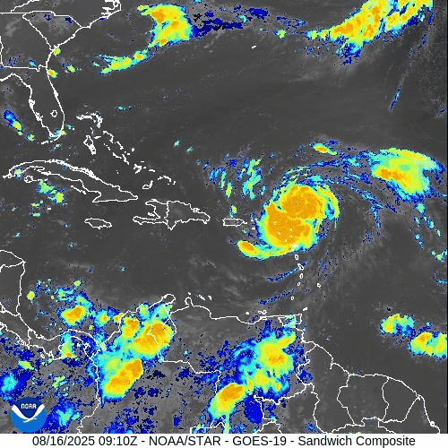
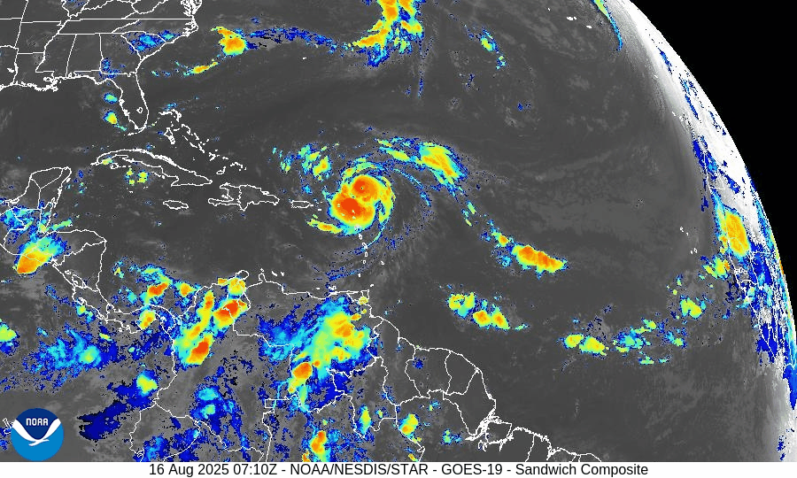
Atlantic Hurricane Outlook – August 16, 2025: Erin intensifies over the central Atlantic
Hurricane Erin has intensified over the central Atlantic while a weak Gulf disturbance delivers rain to South Texas and NE Mexico. Florida sees typical summer storms, with rising rip-current risks along Atlantic beaches as Erin’s swells arrive.
TLDR Version; Click Here

Erin intensifies over the central Atlantic; weak Gulf disturbance keeps rain focused on far South Texas and NE Mexico; U.S. impacts mainly marine
Hurricane Erin has strengthened over the central tropical Atlantic and remains on a track that keeps it well offshore of the U.S. mainland. In the Gulf of Mexico, a weak, broad low near the Bay of Campeche continues to funnel tropical moisture into far South Texas and northeastern Mexico, with low odds of tropical development. For most U.S. coastlines, the primary near-term impacts are building surf and an elevated rip-current risk as Erin’s long-period swells arrive.
Atlantic Basin Overview
Hurricane Erin (central Atlantic): Erin has intensified into a major hurricane over very warm waters with supportive upper-level ventilation. Forecast guidance continues to favor a gradual bend to the northwest and then north this weekend into early next week, keeping the core well away from the Bahamas and U.S. East Coast. Even with an offshore track, long-period swells will propagate toward the Western Atlantic shorelines, bringing hazardous surf and rip currents ahead of any weather changes locally.
Elsewhere in the basin: A typical mid-August “wave train” extends from Africa across the Main Development Region (MDR). Most waves are battling pockets of dry air/Saharan dust and intermittent mid- to upper-level shear, limiting organization in the short term.


Gulf of America (Mexico) & Caribbean
Southwest Gulf disturbance (Bay of Campeche): A broad trough/weak low continues to drift west-northwest toward northeastern Mexico. Organization is limited; development odds remain low. Regardless of development, expect periods of heavy rain, locally gusty squalls, and choppy seas from the lower Texas coast southward into Tamaulipas/Veracruz.
Rest of the Gulf: Typical summer regime with scattered sea-breeze thunderstorms near the margins; light to moderate onshore flow most areas, with evening pulses of fresh easterlies along the Yucatán coast.
Caribbean Sea: Fresh trades continue in the south-central Caribbean with passing showers; no organized tropical systems at this time.
Florida & Southeast U.S. Outlook
Florida (statewide): A classic August pattern—hot, humid, and scattered to numerous afternoon thunderstorms driven by sea-breeze collisions and outflow boundaries. Storms are not tropical in origin but can produce frequent lightning, brief torrential rain, and localized gusty winds.
Atlantic beaches (FL/GA/SC/NC): Expect a rising rip-current risk and building surf through the weekend into early next week as Erin’s swells arrive. Check local beach forecasts and heed lifeguard guidance.
Gulf beaches (FL Panhandle/West FL): Typical late-day storms; rip-current risk mainly tied to local winds and storm outflows rather than distant swell.
Rain forecast visualization courtesy of Windy.com
Environmental Setup (Why/Why Not Development)
Sea Surface Temperatures: MDR, Caribbean, and Gulf waters are well above seasonal averages, supplying ample oceanic heat content (fuel) for systems that find a favorable atmospheric window.
Wind Shear: Shear is comparatively lower along Erin’s corridor (supporting its intensification) but patchy and occasionally moderate to high elsewhere—enough to disrupt other waves.
Moisture & SAL: Mid-level moisture is increasing west of ~45–50°W, but Saharan Air Layer intrusions still clip portions of the eastern/central MDR, injecting dry air and capping convection for several waves.
Preparedness Note

Even when a hurricane stays far offshore, its swells can be dangerous. If you’re heading to the beach, swim near lifeguards, avoid jetties/inlets during high surf, and review local rip-current statements. For Gulf communities under heavy rain today, avoid flooded roadways and allow extra travel time.
TL;DR – August 16 Snapshot
Erin is a major hurricane over the central Atlantic; expected to turn north and remain offshore of the U.S.
Bay of Campeche disturbance: Low development odds; brings heavy rain to far South Texas and NE Mexico.
Florida & Southeast: Typical hot, stormy afternoons; rip-current risk rising on Atlantic beaches from Erin’s distant swells.
Overall Atlantic remains active with waves, but shear and dry air are limiting most systems—for now.

Atlantic Hurricane Outlook – June 2, 2025: A Quiet Morning, But Don’t Get Comfortable
June 2, 2025 Atlantic hurricane update: Calm skies for now, but unusually warm sea surface temperatures and shifting atmospheric conditions could spark activity later this month. Stay prepared with the latest forecasts and safety tips.
The second day of the 2025 Atlantic hurricane season begins under calm skies, but seasoned forecasters know better than to be lulled by the stillness. With sea temperatures running hot and atmospheric patterns shifting toward favorability, this quiet start may not last long.
Atlantic Basin: All Clear—For Now
As of this morning’s update from the National Hurricane Center (NHC), there are no active tropical cyclones, no areas of interest, and no tropical development expected over the next seven days.
This early-season lull is common in the first half of June, but warm waters and waning atmospheric inhibitors are quietly setting the stage for activity later this month.
Satellite data courtesy of Windy.com
Ocean Heat: The Hidden Fuel Source
Sea surface temperatures (SSTs) across the Atlantic basin are unusually high for this time of year—creating the potential for rapid storm intensification when development does occur:
Gulf of America (Mexico): Running 2–4°F above average, with large swaths above 86°F (30°C)
Caribbean Sea: Above-average temperatures, especially in the western basin
Main Development Region (MDR): Continuing to trend hot
Warm water is the engine that powers tropical cyclones, and the basin is already running well above operating temperature.
Sea surface temperature (SST) data courtesy of Windy.com
ENSO Status: La Nada Means No Safety Net
The El Niño–Southern Oscillation (ENSO) remains in a neutral phase, a state meteorologists often refer to as "La Nada."
El Niño has ended, removing the high wind shear that often suppresses Atlantic hurricanes
La Niña has not yet begun, but conditions may be trending in that direction later this summer
Neutral ENSO removes large-scale inhibitors, allowing the Atlantic to operate unchecked
Historically, neutral ENSO years correlate with average to above-average tropical storm activity.
Wind data courtesy of Windy.com
Saharan Air Layer: Dust Still Offers a Buffer—for Now
The Saharan Air Layer (SAL) continues to stretch across the tropical Atlantic, providing a temporary shield against storm formation:
Introduces dry, stable air into the atmosphere
Inhibits convection and cloud development
Increases wind shear in the central Atlantic
The SAL typically weakens by late June, making it easier for tropical waves to grow and organize.
Saharan Air Layer (SAL) dust data courtesy of Windy.com
Florida Forecast: A Summer Day with a Side of Humidity
Today’s conditions across Florida reflect typical early-June weather:
North Florida: Highs in the upper 80s, low humidity, and mostly sunny skies
Central Florida: Highs around 90°F, building humidity, and isolated afternoon storms
South Florida: Warm and muggy with highs in the mid-80s and a greater chance of scattered storms after 2 PM
It’s a classic Florida day—but the kind that often precedes the real tropical drama in July and August.
Weather radar forecast data courtesy of Windy.com
Prep Tips: Take Advantage of the Calm
With no storms on the map, today is a perfect day to prepare:
Review your hurricane plan and evacuation routes
Restock your hurricane kit
Double-check home insurance coverage
Take photos of property and valuables
Sign up for local emergency alerts
Bookmark trusted sources like Cat5Prep.com and the National Hurricane Center
Looking Ahead: Eyes on the Tropics
We remain in a short-term window of calm, but all indicators suggest that activity will ramp up in the coming weeks. Record-breaking sea surface temperatures and favorable upper-atmospheric trends point to early-season development potential later in June.
Stay alert. Stay ready. And check back tomorrow for your next update from Cat5Prep.

*As an Amazon Associate, we earn from qualifying purchases.