Atlantic Hurricane Outlook – August 13, 2025: Erin Expected to Become 2025’s First Major Hurricane; U.S. Coast Still Unthreatened
Tropical Storm Erin is gaining strength in the Atlantic and could reach major hurricane status this weekend. Forecasts keep it well offshore, but the Southeast coast will see increasing surf and rip currents. Gulf and Florida remain quiet.
A couple disturbances being monitored along with TS Erin
TLDR Version: Click Here
Tropical Storm Erin is continuing its westward progression across the eastern Atlantic, with strong model agreement that it will likely intensify into a major hurricane this weekend. While its path remains well east of the U.S., coastal regions should prepare for elevated surf and rip current risks in the coming days.
Atlantic Basin Overview
Tropical Storm Erin remains steady with sustained winds of 45 mph, moving west at 20 mph.
Forecasts now indicate Erin may become a Category 3 hurricane by Sunday, as environmental conditions improve.
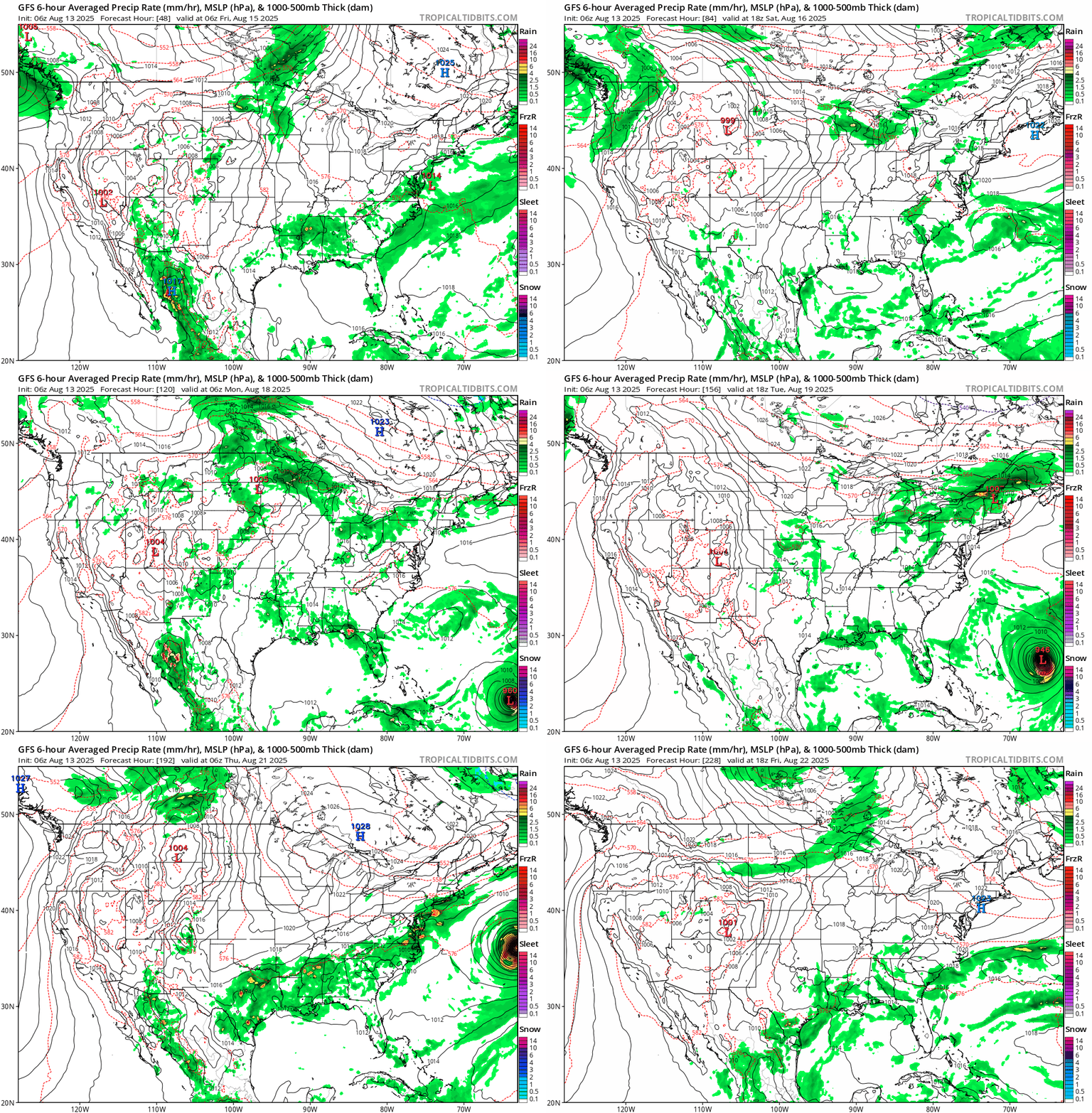
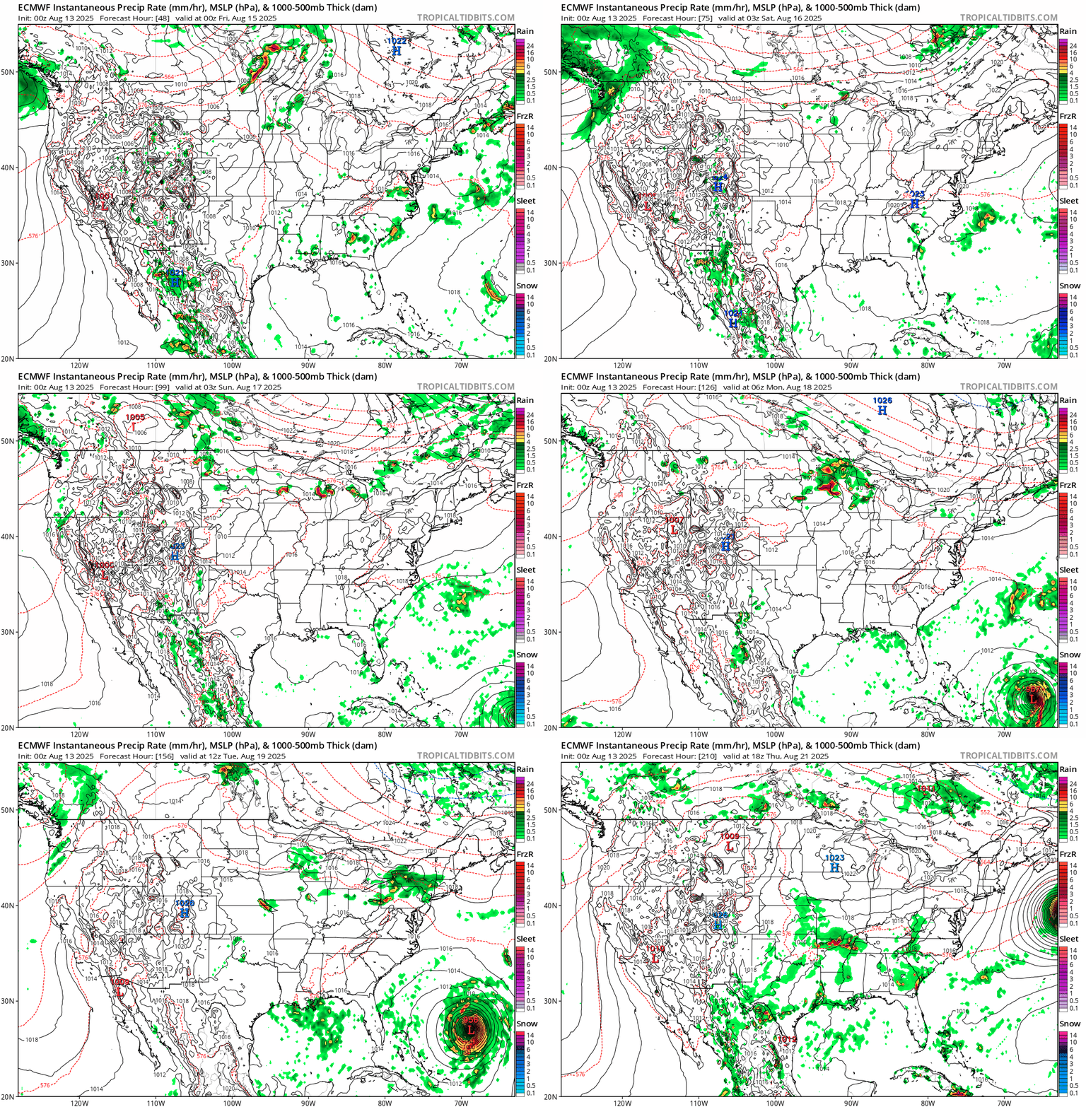
Some models suggest Erin will pass north of the northern Leeward Islands, with a likely northwest turn before reaching the Bahamas—thereby minimizing direct U.S. impacts.
Meanwhile, Invest 96L and other tropical waves remain under observation, but Erin is the dominant system for now.
Gulf of America (Mexico) & Caribbean Conditions
Gulf of America (Mexico): Calm and quiet. Sea surface temperatures are approximately 2°F above average, creating favorable conditions—but without current disturbances.
Caribbean Sea: Trade winds and typical convection dominate. No organized systems at this time.
GOES - GULF - Sandwich - August 13, 2025
GOES - Caribbean - Sandwich - August 13, 2025
Florida & Southeast Outlook
Forecast: Expect hot, humid conditions with typical afternoon sea-breeze thunderstorms. These are non-tropical and not linked to Erin.
Marine Hazards: Elevated surf and dangerous rip currents are becoming a concern along the Southeast coast due to Erin’s offshore activity.
Rain forecast visualization courtesy of Windy.com
Looking Ahead & Preparation
Erin is on track to intensify significantly but should remain well offshore through the weekend.
Continue watching Invest 96L and subsequent waves for potential tropical development.
Residents along the Southeast coast should prepare for marine hazards—not wind or rain threats at this stage.
TL;DR – August 13 Snapshot
Erin is strengthening—expected to become 2025’s first major hurricane.
Forecast track keeps it east of the U.S. mainland.
Gulf and Florida remain calm, with routine summer weather.
Watch for increasing surf and rip current hazards along the Eastern Seaboard.
Stay informed with daily updates on Cat5Prep.
Atlantic Hurricane Outlook – June 1, 2025: Opening Day, But All’s Quiet… For Now
June 1 marks the official start of the 2025 Atlantic hurricane season. No storms are currently active, but rising sea surface temperatures and favorable patterns suggest a potentially busy season ahead.
The Atlantic hurricane season officially begins today, June 1, and while the tropics are currently quiet, forecasters are already eyeing the environmental conditions that could lead to a very active season. For residents in hurricane-prone regions, now is the time to prepare—not relax.
Atlantic Basin: Calm Start to the Season
As of the latest update from the National Hurricane Center (NHC), there are no active tropical systems, no areas of concern, and no immediate threats expected over the next seven days.
This quiet opening is not unusual. Early June often sees little activity in the deep tropics. However, this calm is not expected to last. Sea surface temperatures are running well above average, and the atmospheric setup is trending toward conditions favorable for development later this month.
Satellite data courtesy of Windy.com
Sea Surface Temperatures: Running Hot
The Atlantic basin is notably warm for this early in the season, providing more than enough fuel for potential tropical cyclones.
Gulf of America (Mexico): 2 to 4°F above normal, with widespread areas exceeding 86°F (30°C)
Caribbean Sea: Similar temperature anomalies, especially in the western basin
Main Development Region: Continues trending above average
Historically, warmer-than-average waters correlate with more frequent and intense storms.
Sea surface temperature data courtesy of Windy.com
ENSO Neutral: La Nada Takes Over
The El Niño–Southern Oscillation (ENSO) is now in a neutral phase. With El Niño in the rearview and La Niña not yet in play, we enter what meteorologists call "La Nada"—a neutral state that often removes inhibiting influences on hurricane formation.
Decreased wind shear is expected across the Atlantic basin
A neutral ENSO often correlates with average to above-average storm development
Other patterns, like the Madden–Julian Oscillation (MJO), may become more influential later in the month
Saharan Air Layer: Dust Still in Play
The Saharan Air Layer (SAL) continues to stream across the Atlantic from Africa, bringing with it dry, dusty air that temporarily suppresses tropical development.
Inhibits cloud formation and convection
Increases atmospheric stability
Introduces vertical wind shear
The SAL typically begins to weaken later in June, removing one of the key atmospheric barriers to tropical development.
Saharan Dust SAL data courtesy of Windy.com
Eastern Pacific: Alvin Weakens
Tropical Storm Alvin, the Eastern Pacific's first named storm of the season, formed earlier this week and is now weakening.
Location: Approximately 710 miles south of Baja California
Movement: Northwest at 13 mph
Maximum Winds: 50 mph, weakening
Forecast: Expected to dissipate within 36 hours
Though Alvin poses no threat to land, its formation signals that tropical systems are beginning to stir in the broader region.
Alvin wind accumulation in Eastern Pacific data courtesy of Windy.com
Florida Forecast: Statewide Conditions Typical for June
Across the state of Florida, today's weather reflects classic early summer patterns.
North Florida: Highs in the upper 80s, lows in the mid-60s, low humidity, mostly clear skies
Central Florida: Highs near 90°F, afternoon humidity and a slight chance of thunderstorms
South Florida: Highs in the mid-80s, lows in the upper 70s, muggy with isolated afternoon storms
These are the kinds of conditions that typically precede the onset of more frequent tropical activity in late June and July.
Temperature across Florida data courtesy of Windy.com
Preparation Tips: Start Now, Not Later
With the season now officially underway, take time today to prepare while skies are still clear.
Review your family emergency plan and evacuation zone
Check and restock your hurricane kit
Confirm your insurance coverage and take property photos
Sign up for local emergency alerts and follow trusted forecast sources
Bookmark Cat5Prep.com and the National Hurricane Center
Looking Ahead
Although the season begins on a quiet note, forecasters warn that this calm is likely temporary. Record sea surface temperatures, a neutral ENSO, and easing wind shear all point to increased tropical activity as we move deeper into June.
Stay ready, stay informed, and check back daily for new updates from Cat5Prep.
*As an Amazon Associate, we earn from qualifying purchases.


