
Atlantic Hurricane Outlook – September 15, 2025
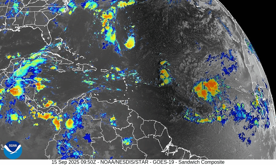
On September 15, the Atlantic remains without active storms, but attention is on a tropical wave in the central Atlantic. The National Hurricane Center gives it a 30% chance of development in 48 hours and 80% over 7 days. Warm waters and easing wind shear may support gradual organization, while dry air and Saharan dust continue to limit rapid strengthening. Florida and the Gulf remain calm, with only routine heat, humidity, and scattered thunderstorms.

Quiet Atlantic continues; a tropical wave off western Africa showing high 7-day development potential
Atlantic Basin Overview
No Active Tropical Cyclones
The Atlantic, Gulf of Mexico, and Caribbean remain storm-free. The National Hurricane Center confirms there are no tropical storms or hurricanes currently active.Tropical Wave in the Central Tropical Atlantic
A tropical wave located in the central tropical Atlantic is producing a large area of disorganized showers and thunderstorms. It is moving west-northwest at 10-15 mph, and environmental conditions are expected to permit gradual development through the week. Formation chances are about 30% over the next 48 hours, increasing to 80% over the next 7 days.
Environmental Conditions
Sea Surface Temperatures (SSTs): SSTs in the tropical Atlantic remain warm enough to support storm formation.
Wind Shear: Moderate shear is present; while it may hinder rapid intensification early on, shear is expected to diminish somewhat near the wave’s path.
Dry Air & Saharan Air Layer (SAL): Dry air and some SAL/ dust intrusions are observed over parts of the eastern Atlantic. These will likely slow initial development but are not expected to completely prevent it as moisture pickup increases.
Gulf of America (Mexico) & Caribbean
The Gulf remains quiet under high pressure. Only routine afternoon and marginal overnight thunderstorms are forecast along coastal zones. No systems are showing organization or threat. Seas are generally modest.
Florida & Southeast U.S. Forecast
Florida is continuing its typical mid-September pattern: hot, humid, with scattered afternoon storms driven by sea breezes. With no tropical systems nearby, there are no tropical threats expected this week. Marine conditions are moderate and normal for this time of year.
Rain forecast visualization courtesy of Windy.com

Summary
The Atlantic remains calm with no active storms.
A tropical wave in the central Atlantic shows high potential (80% over 7 days) to develop, possibly forming a depression by week’s end.
Environmental factors (warm SSTs, reducing shear, some dry air) are mixed—some favorable, some limiting.
Gulf, Caribbean, Florida remain quiet with routine weather patterns.
TL;DR – September 15 Snapshot
Atlantic is quiet; no active systems.
The central tropical Atlantic wave has ~80% 7-day development odds.
Conditions are marginal but becoming more favorable near the wave.
Florida/Gulf remains calm with only the usual summer storms.

Atlantic Hurricane Outlook – September 7, 2025
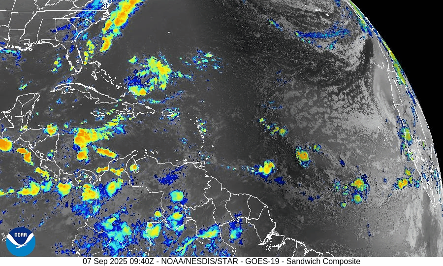
On September 7, the Atlantic remains completely calm with no tropical storms or hurricanes. The National Hurricane Center expects no development over the next 7 days. A weak tropical wave in the central Atlantic is producing scattered showers but shows no signs of organization. Florida and the Gulf of Mexico remain quiet, experiencing only typical late-summer thunderstorms.

**We’re back after a series of technical issues. We apologize for the inconvenience.
TLDR Version: Click Here
Atlantic remains quiet with no tropical development expected in the next week
Atlantic Basin Overview
No Active Storms
The Atlantic basin is completely calm—no tropical depressions, storms, or hurricanes are present. The NHC advises that no tropical cyclone formation is expected over the next seven days.Tropical Waves Noted
A central Atlantic wave near 41°W and 17°N, moving west at 10–15 kt, shows scattered moderate convection—but no sign of imminent development.
Environmental Conditions
Sea Surface Temperatures (SSTs): Still warm across the Gulf and Caribbean (~29–31 °C), but less favorable in the open Atlantic.
Wind Shear: Elevated winds aloft continue across the basin, suppressing convective organization.
Mid-Level Humidity & SAL: Dry air and Saharan dust remain widespread, further limiting storm initiation.
Gulf of Mexico & Caribbean
The Gulf remains quiet and stable, with only typical afternoon sea-breeze thunderstorms occurring along coastal areas. No tropical systems are expected to develop.
Florida & Southeast U.S. Forecast
Florida continues under a late-summer pattern—hot, humid, and featuring scattered afternoon thunderstorms. With no systems nearby and improving sea conditions, no enhanced coastal risks are currently expected.
Rain forecast visualization courtesy of Windy.com

Summary
The Atlantic basin remains quiet, with no active systems or expected development in the short term.
Although tropical waves are present, environmental factors (warm SSTs excluded) are largely unfavorable across the basin.
The Gulf and Florida remain unaffected, experiencing only routine summertime weather.
TL;DR – September 7 Snapshot
No storms in the Atlantic; no development expected for 7 days.
A wave in the central Atlantic shows no signs of imminent organization.
Environmental factors continue to suppress new tropical formation.
Florida and Gulf remain calm with only routine weather patterns.