
Atlantic Hurricane Outlook – August 20, 2025: A Couple Systems In The Atlantic
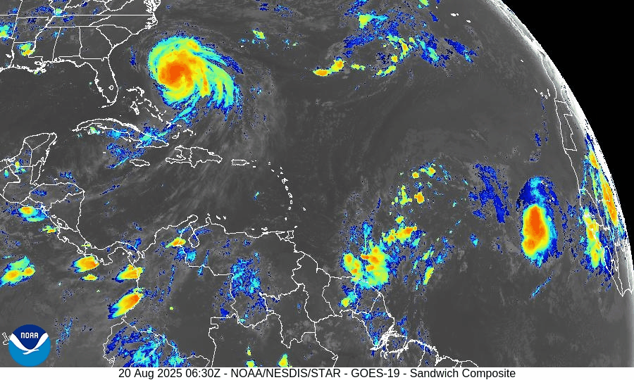
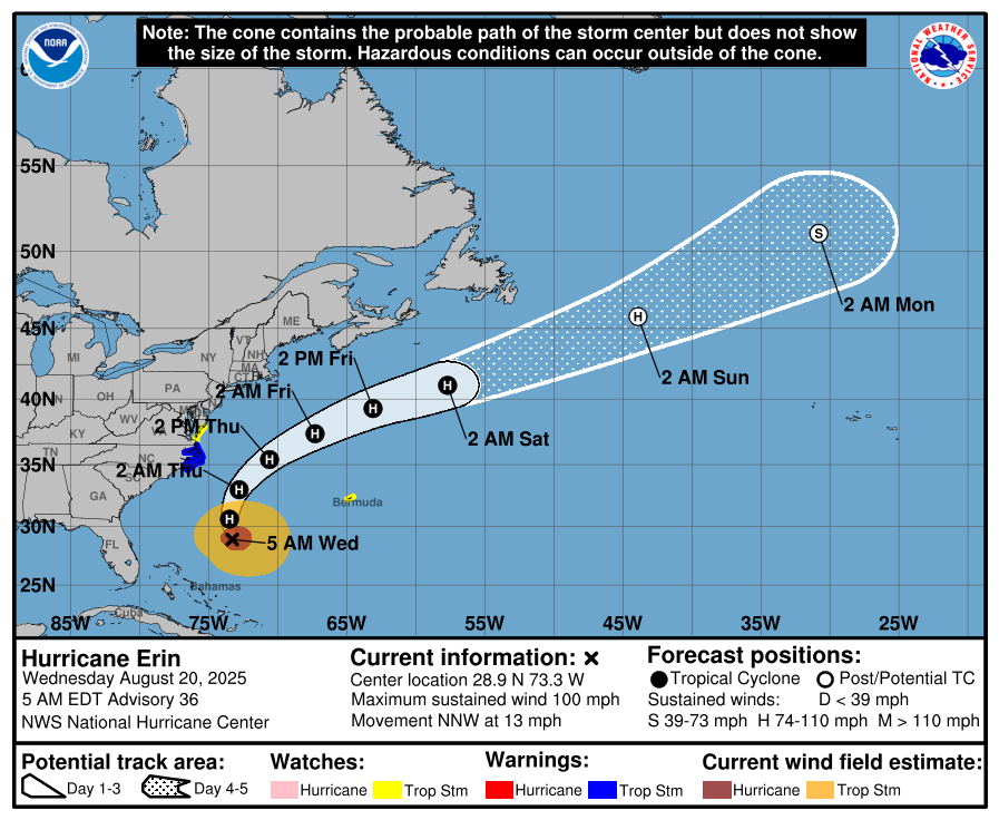
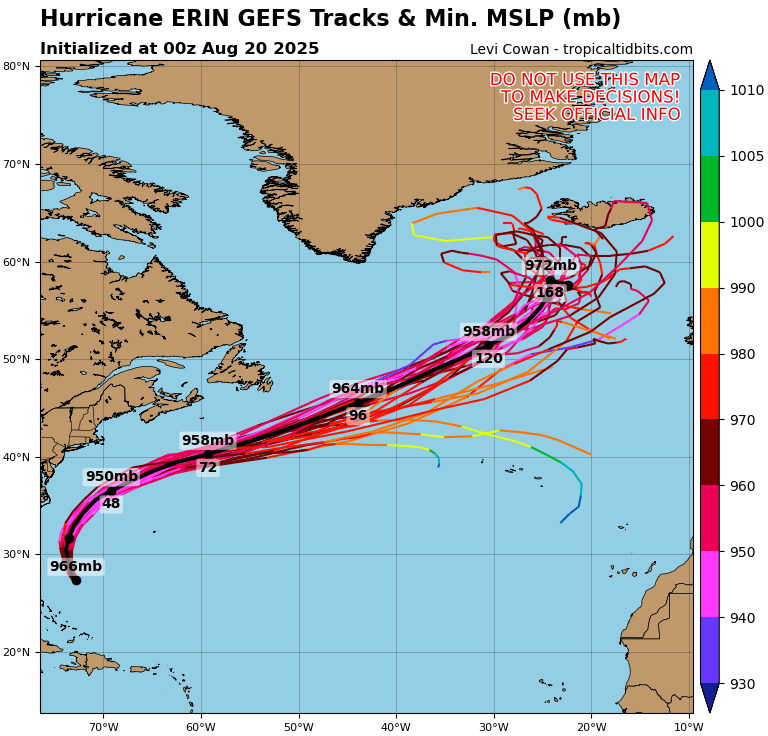
Hurricane Erin is holding as a Category 2 storm offshore, producing rip currents and coastal hazards along the East Coast. Meanwhile, the Gulf and Florida remain quiet, though tropical waves in the Atlantic are being monitored.
TLDR Version: Click Here
Current Tropical Systems

Hurricane Erin:
Erin has weakened slightly but remains a Category 2 hurricane as it tracks northeast, well offshore of the U.S. East Coast. The storm continues to generate dangerous swells, rip currents, and pockets of coastal flooding, especially from the Outer Banks northward into the Mid-Atlantic and New England. While direct landfall is not expected, coastal impacts remain significant.Disturbance in the Central Atlantic:
A tropical wave near 45°W continues to show signs of organization. Environmental conditions feature warm sea surface temperatures but are partially offset by moderate wind shear and Saharan Air Layer (SAL) dust intrusion. Development chances: 30% over 7 days.Far Eastern Atlantic Wave (off Africa):
A fresh wave near 25°W is emerging with scattered convection. It remains disorganized but will be monitored as it progresses westward. Development chances: low (20% over 7 days).


Gulf of America (Mexico) Outlook
The Gulf remains broadly quiet, with high pressure dominating and keeping conditions mostly stable. While moisture pockets are leading to afternoon thunderstorms, there are no signs of tropical development at this time. Sea surface temperatures are very warm (29–31°C), so the region will continue to be monitored closely heading into late August.
Florida Forecast
Florida remains under the influence of high humidity and afternoon sea-breeze thunderstorms, typical for August. Outer rainbands from Erin are not expected to impact the peninsula. No immediate tropical threats are forecast for the state in the near term.
Rain forecast visualization courtesy of Windy.com
Key Environmental Factors
Sea Surface Temperatures (SSTs): 29–31°C across the Gulf and Caribbean, MDR slightly above average — supportive for development.
Wind Shear: Moderate over the central Atlantic, helping limit wave organization.
Moisture: Gradual increase in the western Atlantic, but SAL dust continues to suppress deep convection in parts of the MDR.

Outlook Summary
Hurricane Erin remains a strong offshore system, generating significant surf and rip currents along the East Coast.
Central Atlantic disturbance carries moderate development potential but faces shear and dust challenges.
Gulf of Mexico and Florida remain calm with no immediate tropical concerns, though warm waters warrant close monitoring later this month.
TL;DR
Hurricane Erin is now a Category 2 offshore system, still driving dangerous surf and rip currents up the East Coast. The Gulf of Mexico and Florida stay quiet with only scattered thunderstorms, while the central Atlantic wave shows some development potential but is being held back by wind shear and Saharan dust.

Atlantic Hurricane Outlook – July 20, 2025: Tropical Wave Parade Signals a Shifting Pattern
Multiple tropical waves are moving across the Atlantic, including a monitored disturbance near 40°W and a new wave off the African coast. While no tropical cyclones are active, conditions are being closely watched for signs of development.
As we close out the third week of July, the Atlantic remains without named storms—but activity is clearly on the upswing. Multiple tropical waves stretch across the basin, including a disturbance in the central Atlantic, a new wave off Africa, and a low near 08N44W. While none are close to development yet, we are seeing textbook signs of a transitioning pattern that could prime the Atlantic for August’s ramp-up.
Atlantic Basin: Watching Several Waves
As of the 8:00 AM EDT Tropical Weather Outlook and 0600 UTC Surface Analysis:
No active tropical cyclones
One area of interest with low development chances (20%): A tropical wave near 40°W continues to be monitored.
New tropical wave introduced: Near 23°W in the far eastern Atlantic (off Africa), moving westward with convection along its southern flank.
Low pressure near 08N44W embedded in the monsoon trough is helping spark convection.
Disturbance 1, the central Atlantic wave, continues to move westward at 10–15 knots. While still disorganized, it maintains scattered convection and remains under close watch. Other waves in the deep tropics—including the new one off Africa—will be tracked for organization over the coming week.
NOAA/NESDIS/STAR – GOES-19 Air Mass Composite – July 20, 2025
Sea Surface Temperatures: Warm and Welcoming
Ocean heat content remains very favorable:
Gulf of Mexico: 86–89°F (30–32°C)
Western Caribbean: Holding steady at 86°F+
Main Development Region (MDR): Near-to-above normal, especially between 30W and 50W
There is no shortage of storm fuel—the atmosphere just needs to catch up.
Sea Surface Temperature data courtesy of Windy.com
Wind Shear & Moisture: A Gradual Shift
Wind shear remains moderate in the central and western Atlantic, but is forecast to slowly ease.
Dry air from the Saharan Air Layer continues to impede vertical development of tropical waves, especially in the MDR.
Moisture is increasing around the Intertropical Convergence Zone and the Caribbean, a key precursor for storm organization.

Wind Shear Courtesy of https://tropic.ssec.wisc.edu/
Relative Humidity (ECMWF) data courtesy of Windy.com
Saharan Air Layer: Still in Control—for Now
The SAL remains widespread across the eastern and central Atlantic, with effects including:
Dry air entrainment disrupting convective growth
Stronger mid-level winds inhibiting vertical cloud development
This suppression is expected to loosen over the next 7–10 days, coinciding with climatological acceleration.
Saharan Air Layer (Dust) data courtesy of Windy.com
Monsoon Trough & Convection: Activity Percolating
A monsoon trough stretches from western Africa to near 46°W and supports scattered convection, particularly around 08N44W.
The new wave near 23°W is accompanied by moderate convection—early signs of organization.
Another tropical wave has now moved inland over Central America and is now being monitored in the East Pacific.
Satellite imagery courtesy of Windy.com
Gulf of Mexico: Typical July Pattern, But Shifts Ahead
A surface trough over the Bay of Campeche is causing showers and thunderstorms in the far southwestern Gulf.
Another weak trough across Florida is sparking isolated thunderstorms off the Gulf coast near Naples.
A weak high near the northeast Gulf continues to dominate.
Looking ahead:
Winds could increase by Thursday across the NE Gulf as broad low pressure moves across the southeastern U.S. and possibly into the northern Gulf.
Widespread showers and thunderstorms expected midweek across the east and north-central Gulf waters.
Surface pressure data (ECMWF) courtesy of Windy.com
Caribbean Sea: Breezy and Stormy in the South-Central Basin
Fresh to strong NE to E winds continue in the south-central Caribbean, with seas of 8–11 ft.
Moderate to fresh trades elsewhere with 4–7 ft seas.
Scattered storms noted near Haiti, eastern Cuba, and Panama’s western coast.
A tropical wave expected midweek will bring enhanced shower and thunderstorm activity across the eastern Caribbean and Windward Passage.
Wave height forecast (ECMWF Waves) courtesy of Windy.com
Florida Forecast: Classic Mid-July Conditions
Expect hot and stormy conditions today:
Highs: Around 93°F (34°C)
Humidity: High, with heat index values near 102°F
Storms: Scattered afternoon and evening thunderstorms—non-tropical but locally strong
Winds: Light and variable
Rainfall forecast (ECMWF) courtesy of Windy.com
Prep Tip of the Day: Start Prepping for August, Not Reacting to It
With the tropics on the edge of activity, now’s the time to get ahead:
Replenish your hurricane kit (water, food, medicine, power banks)
Make sure your contact list includes out-of-area family
Stay signed up for emergency alerts in your area
Looking Ahead: Calm Now, But the Tropics Are Flexing
Though no storms are imminent, tropical waves are increasingly active, sea temperatures are peaking, and dry air is slowly loosening its grip.
This is the time to watch, prepare, and not underestimate how quickly conditions can change. Stay with Cat5Prep.com for daily, real-time updates you can trust.

Atlantic Hurricane Outlook – June 18, 2025: Tropics Stay Quiet as Pacific Storms Steer Focus
The Atlantic remains storm-free on June 18, with no tropical systems expected over the next 7 days. But warming ocean temps and an active Pacific raise long-range concerns.
The Atlantic basin remains calm today, with no active tropical cyclones and no systems being monitored for development in the National Hurricane Center’s latest 2 AM EDT outlook. This early-season quiet continues, but shifting global patterns—warm oceans, dust, and Pacific activity—are fueling a cautious watchfulness.
Atlantic Basin: Clear, But Keep Watching
No Atlantic systems are active, and the seven-day forecast shows no tropical development expected this week . While mid-June calm is common, meteorologists note stronger global volatility due to cross-basin interactions and shifting climate signals.
Satellite view via Windy.com
Pacific Spotlight: Tropical Storm Erick on the Rise

Wind Speed Probability Tropical Storm Erick
All eyes are on the Eastern Pacific, where Tropical Storm Erick is rapidly strengthening—forecast to become the season’s first Pacific hurricane. Though Erick poses no threat to U.S. shores, it demonstrates the early-season dynamism that Atlantic may encounter soon.
Wind Gust Accumulation Forecast (ECMWF) via Windy.com
Sea Surface Temperatures: Heat Builds Beneath the Calm
Gulf & Western Caribbean: SSTs remain well above average (84–88 °F), providing potential fuel.
Main Development Region (MDR): Water temperatures are warming and trending warmer than early June norms, laying a foundation for development later in the season.
Sea Surface Temperature via Windy.com
Saharan Dust & Atmospheric Inhibitors

Wind Shear Courtesy of https://tropic.ssec.wisc.edu/
A large plume of Saharan dust continues to stretch across the Atlantic and into the Caribbean and Southeast U.S., suppressing tropical formation and degrading air quality.
This dust layer, combined with moderate wind shear, continues to inhibit tropical systems.
Saharan Air Layer (Dust) via Windy.com
Thunderstorm Activity: Summer Rhythm
Florida & Southeast U.S.: Expect standard afternoon thunderstorms, born from daytime heating—not tropical phenomena.
Caribbean & Atlantic: Skies remain clear, with no clusters or organic storms forming.
Air Quality Alert: Sensitive groups should note haze and dust over the Southeast.
Thunderstorm Forecast (ECMWF) via Windy.com
Florida Forecast (June 18)
Highs: Upper 80s to low 90s°F (31–33 °C)
Humidity: High, with muggy conditions
Rain: Isolated to scattered afternoon storms
Visibility: Reduced by dust haze in some regions
Winds: Light, stronger near storms
Rainfall Forecast (ECMWF) via Windy.com
Prep Tip of the Day: Monitor Dust and Air Quality
Minimize outdoor exposure if you’re sensitive to dust
Clean or replace filters in HVAC systems
Keep monitoring dust levels through local air-quality alerts
Continue hurricane planning while skies are calm
Looking Ahead: Still Quiet, But Global Trends Are Stirring
No Atlantic storms are expected this week. However:
SSTs remain elevated
Wind shear may ease gradually
Saharan dust may shift or thin
Eastern Pacific activity—like Erick—offers insight into potential future Atlantic behavior
Use this calm period to prepare. Tomorrow could bring the first tropical ripple, so stay connected to Cat5Prep for ongoing updates.