
Atlantic Hurricane Outlook – October 10, 2025
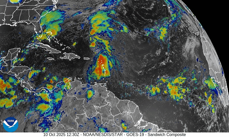
On October 10, Tropical Storm Jerry is weakening as it turns northward in the Atlantic, while a developing Nor’easter off the U.S. East Coast brings flooding rains, high surf, and coastal winds to the Mid-Atlantic and New England. Subtropical Storm Karen continues to fade over the northern Atlantic, and no new tropical systems are expected. Florida and the Gulf of America remain calm aside from elevated surf.

Tropical Storm Jerry weakens; Subtropical Storm Karen fading; Nor’easter developing off the U.S. East Coast
Atlantic Basin Overview
Tropical Storm Jerry
Jerry is located about 80 miles north-northeast of the Northern Leeward Islands, moving northwest at ~17 mph, with maximum sustained winds of 50 mph. Tropical-storm-force winds extend outward nearly 185 miles to the east of center.
Jerry continues to battle moderate to strong wind shear and dry mid-level air, keeping its convection displaced from the low-level center. Gradual weakening is expected as it curves north, and Jerry could lose tropical characteristics by Saturday, becoming post-tropical as it interacts with an upper trough.Subtropical Storm Karen
Karen, in the far North Atlantic, is weakening over cooler waters and increasing shear. It will transition to a post-tropical low within 24 hours and pose no threat to land.Non-Tropical Coastal Storm / Nor’easter (Western Atlantic)
A strengthening non-tropical low has formed just off the Mid-Atlantic and Northeast U.S. coastline, drawing deep Atlantic moisture into the region.
This hybrid system—not yet tropical but highly impactful—is producing:
• Heavy rain and coastal flooding from New Jersey through New England
• Gale- to storm-force winds along the coast and offshore waters
• Dangerous surf, rip currents, and beach erosion extending through the weekend
The system will likely intensify further as it moves north-northeast, behaving more like a Nor’easter than a tropical cyclone. While not classified as tropical, its impacts on populated areas are as significant as a weak hurricane, and it should be treated with equal caution by coastal interests.
Environmental Conditions
Sea Surface Temperatures (SSTs):
Warm (28–29 °C) near Jerry’s current location, but cooling rapidly northward. The Nor’easter’s energy source is baroclinic (temperature-gradient driven) rather than tropical heat.Wind Shear:
Strong upper-level winds dominate the western Atlantic—one reason Jerry is weakening and why the Nor’easter is deepening outside the tropics.Humidity & Dry Air / SAL:
Dry Saharan air continues to limit convection around Jerry’s western flank; mid-latitude dry slots are also influencing the Nor’easter’s structure.
Gulf of America & Caribbean
The Gulf of America and Caribbean remain calm, with no organized tropical activity. Conditions are dominated by localized thunderstorms and standard early-October convection.
Florida & Eastern U.S. Forecast
Florida: No tropical threats. Expect humid, stormy afternoons and increased rip current risk from Atlantic swells.
Eastern Seaboard (Mid-Atlantic to New England): Impacts are already underway from the non-tropical coastal storm / Nor’easter—including gusty winds, heavy rain, and flooding tides. Residents should monitor local advisories and coastal flood warnings.
Rain forecast visualization courtesy of Windy.com

TL;DR – October 10 Snapshot
Jerry: 50 mph tropical storm curving north, expected to weaken and turn post-tropical soon.
Karen: Subtropical storm weakening over the North Atlantic.
Nor’easter: Powerful non-tropical coastal storm developing off the Eastern U.S.—causing flooding, wind, and surf hazards through the weekend.
Gulf & Caribbean: Quiet.
Florida: No direct threats but increased surf.