
Atlantic Hurricane Outlook – August 15, 2025: Erin Nears Hurricane Strength
Tropical Storm Erin is strengthening and may become the first hurricane of the season this weekend, while Invest 98L in the Gulf delivers heavy rain to South Texas. U.S. land impacts remain limited to surf and rip currents.
TLDR Version, Click Here

Erin Nears Hurricane Strength; Gulf Disturbance Spreads Moisture into Texas; U.S. Coastal Impacts Mostly Marine
Tropical Storm Erin is on the verge of becoming a hurricane—likely the season's first. Meanwhile, Invest 98L in the Bay of Campeche is bringing increased rain chances to South Texas. The U.S. mainland remains free of direct tropical threats, but coastal surf and rip currents from Erin warrant awareness.
Atlantic Basin Overview
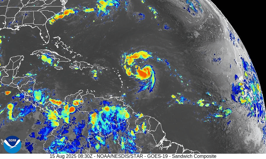
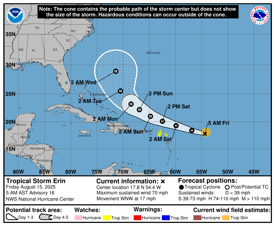
Tropical Storm Erin has intensified, with sustained winds now around 60 mph and tropical storm-force winds extending from a compact core.
Hurricane Hunter aircraft are en route to assess the system. Erin is expected to become a Category 1 hurricane by Friday, with potential escalation to Category 3 (major) over the weekend.Forecast track: Currently on a west-northwest path, Erin is projected to steer northward later and remain offshore of the U.S.–Bahamas corridor, possibly passing near Bermuda. Direct U.S. land impacts are unlikely, but marine hazards will increase.


Gulf of Mexico & Caribbean Conditions
Invest 98L (Bay of Campeche): The disturbance now carries a 40% chance of development over 48 hours and 20% over 7 days. Although tropical cyclone formation is not expected, heavy rain and elevated coastal flooding risk (including rip currents) continue for South Texas.
Caribbean Sea: Stable with typical trade-wind rains and no organized tropical systems.
GOES-19 - Sector view: Gulf of America - Sandwich
GOES-19 - Sector view: Caribbean - Sandwich
Florida & Southeast Forecast
Florida: Persistent heat and humidity prevail with typical afternoon sea‑breeze thunderstorms. These storms are non-tropical in nature.
Marine Impact from Erin: Long-period swells and rip currents will begin affecting East Coast beaches, especially in Florida and the Southeast, as Erin intensifies. Coastal vigilance is advised.
Rain forecast visualization courtesy of Windy.com
Environmental Analysis
Sea Surface Temperatures: Warm—ranging from 84°F to 88°F—support rapid intensification of Erin.
Wind Shear & Atmospheric Moisture: Shear is forecast to decrease and mid-level moisture is sufficient, favoring intensification. Meanwhile, dryness and SAL (Saharan dust) remain more prevalent in other parts of the MDR, limiting additional activity.
Summary & Preparation Notes

Erin is nearing hurricane strength and likely to reach major category. Track keeps it offshore, but surfers and beachgoers should prepare for dangerous surf and rip currents.
Invest 98L will deliver rain to Mexico and South Texas; expect localized flooding.
No immediate threats to Florida or the U.S., but this weekend’s marine hazards are real.
Use this time to confirm emergency plans, especially for any coastal or marine activities.
TL;DR – August 15, 2025
Erin strengthening fast—on track to become a hurricane this weekend.
No direct U.S. impact expected, but surge in surf and rip currents along the Southeast coast.
Invest 98L brings rain to South Texas; low development chances.
Florida sees normal summer weather—hot and stormy, but not tropical.
Coastal watch: Swells and rip current impacts rising; stay informed for Hurricane Updates at CAT5Prep.com
Atlantic Hurricane Outlook – August 1, 2025: Quiet Tropics, Conditions Gradually Shifting
No storms expected as August begins, but multiple tropical waves are being tracked. Conditions are evolving and a shift toward higher hurricane activity is expected in the coming weeks.
*Those who like data, continue reading. Those it prefer the quick version, jump to the TL;DR here.
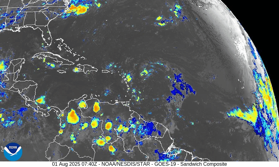
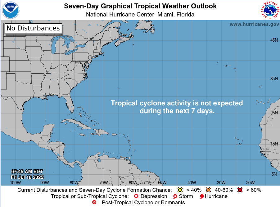
As we enter August—historically the onset of peak Atlantic hurricane activity—there are no active tropical cyclones and no development expected over the next seven days. However, several tropical waves are moving westward, and environmental conditions are slowly transitioning toward a more favorable pattern for storm formation later in the month.
Atlantic Basin Overview
According to the 8:00 AM EDT Tropical Weather Outlook (TWO) from the National Hurricane Center:
Tropical cyclone formation is not expected during the next 7 days WikipediaNational Hurricane Center
While no waves are currently listed as having development potential, multiple waves are traversing the eastern Atlantic.
Tropical Waves & Deep Tropics
Forecast models highlight several waves across the Atlantic, though none show organization yet:
A wave near 43–50°W, moving west at ~10–15 kt, producing scattered convection.
Another wave near 30°W, just moving off Africa, with intermittent thunderstorms.
These waves will be closely monitored as they enter warmer waters and encounter decreasing wind shear.
Environmental Conditions Snapshot
Sea Surface Temperatures (SSTs):
Gulf of Mexico & Caribbean: 29–31 °C (84–88 °F), sustaining high energy potential.
MDR: Slightly above-average values, but cooling compared to June trends .
Wind Shear:
Elevated across the Caribbean and central Atlantic—a limiting factor in early July—but gradual easing is forecast by mid-August.
Saharan Air Layer (SAL):
Persistent dry air suppressing convection across most of the MDR, but expected to weaken soon.
Atmospheric Moisture:
Enhanced moisture is slowly building in the western Atlantic, improving potential for organized convection.
Gulf of America (Mexico) & Caribbean Conditions
No disturbances are being tracked.
A dominant high-pressure ridge produces stable flow across both basins.
Offshore marine conditions remain calm, with scattered showers typical for this time of year.
Gulf of America (Mexico)
Caribbean
Florida Forecast
Highs: Low 90s °F, sticky and humid.
Precipitation: Scattered afternoon storms driven by afternoon heating and sea breeze convergence.
Winds: Light and variable inland, shifting southeast near the coast.
Rain forecast visualization courtesy of Windy.com
Prep Tip of the Day: Bookmark Tropical Outlook Sources
With activity still weeks away:
Confirm you can receive alerts from the National Hurricane Center.
Bookmark reliable sources such as Cat5Prep.com.
Ensure household members know where your hurricane documents and kits are stored.
Outlook
No cyclone formation is expected this week, but climatology and model trends suggest early-to-mid August could mark the beginning of increased tropical activity. The bulk of Atlantic season activity historically occurs after August 1, with the first hurricane typically forming around August 11.
TL;DR – August 1, 2025 Atlantic Forecast
No active or developing storms in the basin.
Several tropical waves tracked, none organized.
SSTs are warm; shear and SAL still suppressive.
A shift toward higher activity likely in early August.
Today is a good day to finalize hurricane plans and stay alert.
Atlantic Hurricane Outlook – July 18, 2025: Tropics Quiet, But Gulf Moisture Persists
The Atlantic remains free of tropical storms today, but rising ocean heat and evolving atmospheric patterns point to potential development in the coming weeks. Stay prepared with Cat5Prep's daily hurricane outlook.
The Atlantic basin remains relatively quiet as we enter the weekend, with no active tropical cyclones or immediate threats on the map. However, lingering moisture from a weak low in the Gulf of Mexico continues to impact parts of the Southeast with enhanced rain chances. Meanwhile, environmental signals are gradually shifting toward favorability as we move closer to the climatological ramp-up in late July.
Atlantic Basin: Still Quiet, But Watchful
As of this morning’s update from the National Hurricane Center (NHC):
No active tropical cyclones
No named systems or advisories
No tropical development expected over the next 7 days
The basin remains in a holding pattern—but that may change in the weeks ahead.
Satellite imagery courtesy of Windy.com
Sea Surface Temperatures: Running Hot
Ocean heat content continues to build across key development zones:
Gulf of Mexico: Sea surface temperatures (SSTs) remain in the mid-to-upper 80s°F (29–31°C), well above average.
Western Caribbean: Waters continue to warm, supporting deep convection.
Main Development Region (MDR): SSTs between Africa and the Caribbean are approaching thresholds that historically support long-track hurricanes.
These conditions set the stage for rapid intensification when tropical systems do form.
Sea Surface Temperature data courtesy of Windy.com

Wind Shear and Atmospheric Moisture: Becoming More Conducive
While upper-level wind shear remains moderate in parts of the Caribbean and central Atlantic, it is gradually weakening—especially closer to the Gulf. Atmospheric moisture continues to increase:
Mid-level moisture is supporting thunderstorm development
Reduced shear and rising instability create a more supportive environment for potential tropical waves
This combination is worth monitoring as we approach the latter half of July.
Relative Humidity (ECMWF) data courtesy of Windy.com

Wind Shear Courtesy of https://tropic.ssec.wisc.edu/
Saharan Air Layer: A Temporary Shield
Dry air and dust from the Saharan Air Layer (SAL) remain active over the eastern Atlantic:
SAL suppresses convection by drying out the lower atmosphere
It also enhances wind shear, limiting vertical storm growth
This protective layer typically weakens in August
While it currently limits tropical wave development off Africa, its influence is expected to wane soon.
Saharan Air Layer (Dust) data courtesy of Windy.com
Gulf Moisture: Lingering Showers, Low Development Risk
A broad area of low pressure and enhanced moisture remains over the northern Gulf of Mexico:
Development chances remain very low
The system is disorganized, with no surface circulation
Still, heavy rain and localized flooding are possible today along the Gulf Coast, particularly in southern Alabama, the Florida Panhandle, and southeastern Louisiana
This disturbance is more of a rainmaker than a tropical threat but illustrates how even weak lows can impact coastal regions.
Rainfall forecast (ECMWF) courtesy of Windy.com
Florida Forecast: Humid and Storm-Prone
Expect classic July conditions across the state:
North Florida: Highs in the low 90s, partly cloudy, isolated afternoon storms
Central Florida: Around 91°F, muggy, with widespread PM storms
South Florida: Mid-to-upper 80s, very humid, storms possible after 2 PM
Local flooding is possible in poor drainage areas due to repeated rounds of heavy showers.
Thunderstorm forecast (ECMWF) courtesy of Windy.com
Prep Tip of the Day: Review Evacuation Zones
Now is the time to double-check your local evacuation zone and routes:
Know whether you're in a surge or flood-prone area
Identify multiple exit routes in case primary roads are closed
Plan ahead for pets, medication, and transportation
Being familiar with your zone before a storm is one of the best preparedness steps you can take.
Looking Ahead: A Quiet Stretch, But a Shift Is Coming
While the tropics are calm for now, the combination of warming waters, weakening wind shear, and deepening atmospheric moisture signals that a transition to a more active pattern is coming.
Expect activity to increase in late July into early August, as the historical ramp-up in hurricane season begins.
Check back tomorrow for the next update from Cat5Prep.com.