Atlantic Hurricane Outlook – September 30, 2025
On September 30, Tropical Storm Imelda is moving northeast offshore of the U.S. East Coast, with forecasts showing it could become a hurricane near Bermuda. While landfall in the U.S. is not expected, Imelda’s outer rainbands may bring gusty winds and showers to the Southeast. Swells from both Imelda and Hurricane Humberto will continue to generate dangerous surf and rip currents along Atlantic beaches. The Gulf of America and Caribbean remain quiet.

Imelda gaining strength; turns away from U.S. coast; Humberto remains offshore
Atlantic Basin Overview
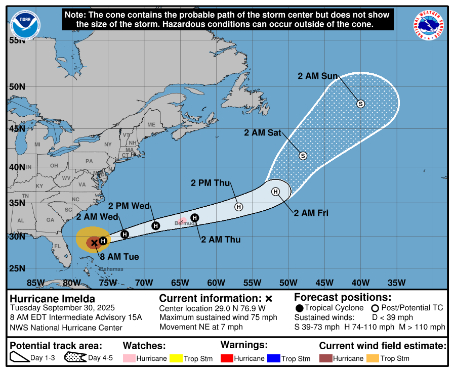
Hurricane Imelda
As of 5:00 AM EDT today, Imelda was centered near 28.8° N, 76.8° W, about 165 mi north of Great Abaco Island and 755 mi WSW of Bermuda.
Imelda is moving northeast at 7 mph and is expected to increase forward speed and turn toward the east-northeast tonight.
Imelda is now a hurricane.Hurricane Humberto & Other Waves
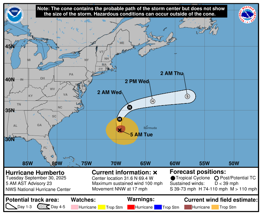
Humberto remains a strong system over the Atlantic and continues to generate swells that affect the U.S. East Coast.
Other Atlantic waves are being monitored, but none show imminent organization or clear paths toward land.
Hurricane Imelda


Hurricane Humberto


Environmental Conditions
Sea Surface Temperatures (SSTs): SSTs in Imelda’s path remain favorable for strengthening; as Imelda moves northeast, it will eventually encounter cooler waters which may begin to inhibit further intensification.
Wind Shear: Moderate shear persists around Imelda, which could slow down its deepening. As it moves further northeast, shear is expected to increase, limiting structural organization.
Humidity & Dry Air / SAL: Dry mid-level air and Saharan dust continue to intrude over parts of the Atlantic, suppressing convection especially in outer bands. These influences also hamper development of easterly waves farther out.
Gulf of America & Caribbean
The Gulf of America and the Caribbean remain calm, with no organized tropical systems currently developing.
Florida & Eastern U.S. Forecast
Florida & Southeast U.S.: The core of Imelda is forecast to remain offshore, turning away before making U.S. landfall. However, coastal and inland areas from Florida up through the Carolinas may experience gusty winds, showers, and elevated surf as Imelda passes east.
Marine Impacts: Swells and rough surf generated by Imelda (and Humberto) will continue to pose dangerous surf and rip current conditions along the Atlantic coast.
Rain forecast visualization courtesy of Windy.com

TL;DR – September 30 Snapshot
Imelda is strengthening, moving northeast, turning away from the U.S., with potential to become a hurricane near Bermuda.
Humberto remains offshore, continuing to generate swells along the East Coast.
SSTs support Imelda’s current growth; increasing shear and cooler waters will likely limit further intensification.
Gulf and Caribbean remain stable and quiet.
Eastern U.S. coast should watch marine impacts, shower bands, and gusty winds from Imelda’s outer rainbands.