Atlantic Hurricane Outlook – September 18, 2025
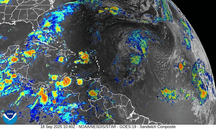
On September 18, Tropical Storm Gabrielle is active in the central Atlantic with maximum sustained winds near 50 mph. Wind shear and dry Saharan air are slowing its development, though gradual strengthening is possible this weekend as conditions improve. A separate tropical wave off Africa has only a low chance of development. Florida and the Gulf of America remain calm with only typical heat, humidity, and scattered afternoon thunderstorms.

Tropical Storm Gabrielle holds offshore; slowly strengthening amid environmental challenges
Atlantic Basin Overview
Tropical Storm Gabrielle
Gabrielle has formed well east of any major landmasses. As of the latest advisory, it’s located about 20.0°N, 50.3°W, moving west-northwest at roughly 15 mph, with maximum sustained winds around 50 mph and a minimum central pressure near 1004 mb. There are no watches or warnings for land at this time.Forecasters expect little change in its strength over the next 1-2 days due to wind shear and dry air interfering with its circulation. Some gradual intensification is possible late this weekend or early next week, especially as it moves into a more favorable environment.
Other Disturbances / Tropical Waves
A tropical wave is expected to move off the west coast of Africa soon; models give it a low chance (near 0%) of development in the next 48 hours, rising to about 20% over 7 days as it tracks west-northwest across the eastern and central tropical Atlantic.
Environmental Conditions
Sea Surface Temperatures (SSTs): SSTs along Gabrielle’s current path are warm enough to support gradual intensification, but they’ll need to remain favorable as it moves northwest.
Wind Shear: Elevated vertical wind shear is affecting Gabrielle now and is expected to suppress rapid strengthening during the next 24-48 hours. Conditions may improve somewhat later, permitting gradual organization.
Dry Air & Saharan Dust: Dry air and Saharan Air Layer (SAL) intrusions continue to disrupt convection, especially on the western side of Gabrielle. These factors are contributing to its somewhat ragged structure.
Gulf of America & Caribbean
The Gulf of America and Caribbean remain quiet with no tropical disturbances showing organization. Weather across these regions continues to be dominated by standard late-summer patterns: heat, humidity, and scattered afternoon showers.
Florida & Southeast U.S. Forecast
Florida remains outside of any immediate tropical threat. Expect typical mid-September conditions: hot, humid, with scattered afternoon thunderstorms. Gabrielle is forecast to remain over open water—no direct impacts expected for Florida or the U.S. coasts currently.
Rain forecast visualization courtesy of Windy.com

Summary
Gabrielle is now a named storm, tracking W-NW, far from land but being watched.
Environmental factors (wind shear, dry air) are inhibiting rapid intensification, though gradual strengthening is possible later.
No other systems currently threaten.
TL;DR – September 18 Snapshot
Tropical Storm Gabrielle is active, but staying offshore with no land threats.
Slow strengthening expected this weekend, if Gabrielle can overcome shear and dry air.
A wave off Africa has low short-term chances, modest 7-day potential.
Florida and Gulf of America remain calm.