
Atlantic Hurricane Outlook – September 16, 2025
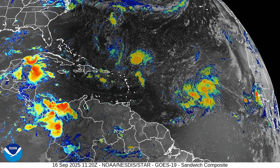
On September 16, Invest 92L in the central Atlantic continues to organize and has a 90% chance of becoming a tropical depression or Tropical Storm Gabrielle in the next 48 hours. Another tropical wave is emerging off Africa with a lower 20% chance of development over 7 days. While warm waters and reduced wind shear support 92L’s growth, dry air and Saharan dust continue to hinder the African wave. Florida and the Gulf remain calm with only typical late-summer storms.

Invest 92L likely to become Tropical Storm Gabrielle; new wave off Africa also being monitored
Atlantic Basin Overview
Invest 92L
A broad area of low pressure known as Invest 92L—located about midway between the Windward Islands and the coast of West Africa—is showing increasing organization. The National Hurricane Center indicates high odds (≈ 90%) of formation into a tropical depression or tropical storm within the next 48 hours and similarly high odds over a 7-day outlook. Forecasts suggest it will move west-northwest or northwest at 10-15 mph. If named, it will be called Gabrielle.New Tropical Wave Off Africa
Another tropical wave is emerging off the western coast of Africa. It has lower odds of development—roughly 20% over 7 days, and near zero in the next 48 hours. It is moving westward toward the central Atlantic, where conditions could improve for gradual organization.
Environmental Conditions
Sea Surface Temperatures (SSTs): SSTs remain warm in the central to western tropical Atlantic, supportive of tropical storm development for disturbances like Invest 92L.
Wind Shear: The upper-level wind shear is decreasing in regions around Invest 92L, aiding its organization. However, moderate shear still exists in other parts of the basin, especially for newer waves emerging off Africa.
Dry Air & Saharan Air Layer (SAL): Dry air and dust from the Saharan Air Layer remain present in parts of the eastern Atlantic, which is damping convection in the newer wave. For Invest 92L, moisture levels are improving, helping its organizational efforts.
Gulf of America (Mexico) & Caribbean
The Gulf of Mexico and Caribbean remain mostly quiet. High pressure dominates, and while afternoon thunderstorms remain routine, no tropical development is expected in these regions in the near term.
Florida & Southeast U.S. Forecast
Florida is under its normal mid-September weather pattern—hot, humid, with scattered afternoon storms. There is no immediate tropical threat to Florida from Invest 92L or the wave off Africa at this time, though residents should monitor forecasts in case the track changes.
Rain forecast visualization courtesy of Windy.com

Summary
Invest 92L is very likely to become Tropical Storm Gabrielle imminently, with high chances over the next 1-2 days.
A new wave off Africa has low development odds now but could gain strength later in the week.
Environmental factors (warm SSTs, easing shear, improving moisture) favor development of Invest 92L, though SAL and dry air still affect newer disturbances.
Gulf, Caribbean, and Florida remain calm with only routine summer weather expected.
TL;DR – September 16 Snapshot
Invest 92L expected to form soon (likely Tropical Storm Gabrielle) with ~90% odds.
New wave off Africa has modest (~20%) 7-day potential.
Conditions are increasingly favorable around Invest 92L.
No tropical threats to Florida or the U.S. currently; routine summer storms only.
Atlantic Hurricane Outlook – September 13, 2025
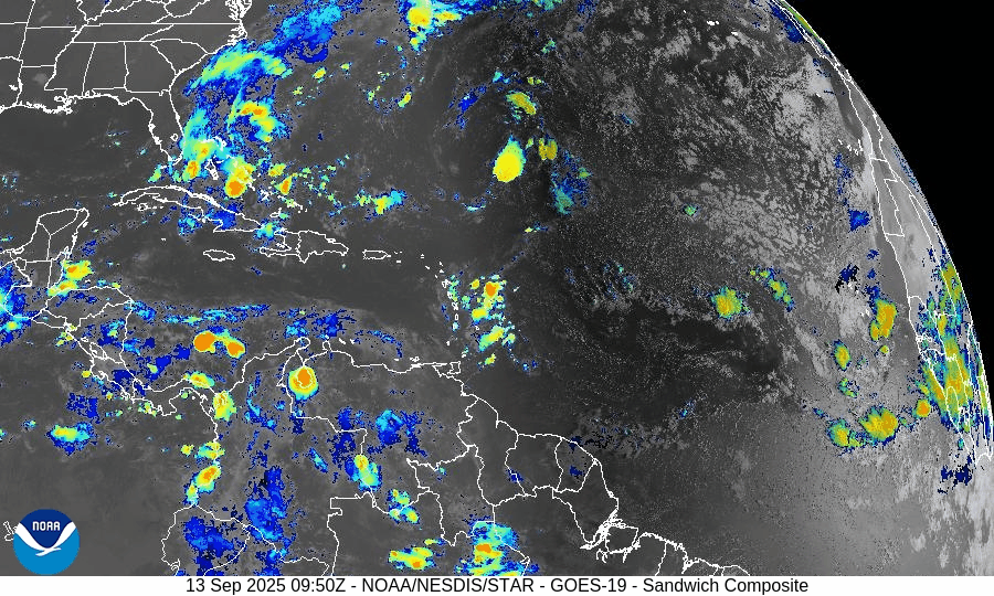
On September 13, the Atlantic basin remains storm-free, with no tropical cyclones currently active. A tropical wave between Africa and the Cabo Verde Islands is producing showers and thunderstorms but faces limited short-term development potential due to dry air and wind shear. The Gulf of Mexico and Florida remain calm, experiencing only the usual heat, humidity, and afternoon storms of late summer.

Atlantic basin quiet; tropical wave off Africa flagged, but development odds remain modest
Atlantic Basin Overview
No Active Tropical Cyclones
There are currently no tropical storms, hurricanes, or depressions in the Atlantic, Gulf of Mexico, or Caribbean. The NHC confirms the basin is calm with no active systems.Tropical Wave Near Africa / Cabo Verde Islands
A tropical wave located between the west coast of Africa and the Cabo Verde Islands is producing some showers and thunderstorms. It’s being monitored. Environmental conditions (dry, stable air) are expected to limit development over the next few days, though a tropical depression could form by the middle to latter part of next week, moving west-northwestward at ~10-15 mph.
Environmental Conditions
Sea Surface Temperatures (SSTs): Warm in the Caribbean and Gulf (~29–31 °C), but the far eastern Atlantic faces somewhat cooler and less supportive SSTs for strong development.
Wind Shear: Moderate to strong upper-level wind shear persists, especially over the regions east of the tropical wave, making rapid intensification unlikely.
Dry Air & Saharan Air Layer (SAL): Significant dry and stable air, partly from the SAL, remains present over much of the eastern and central Atlantic — this is suppressing convective organization in the tropical wave.
Gulf of (America) Mexico & Caribbean
Both regions remain calm under high pressure. Only typical afternoon sea-breeze thunderstorms are occurring. There are no disturbances showing signs of organization in the Gulf or Caribbean.
Florida & Southeast U.S. Forecast
Florida continues with late-summer conditions: hot, humid, with scattered afternoon showers and thunderstorms. With no nearby tropical systems, there are no tropical threats or enhanced coastal risks at this time. Marine conditions are benign.
Rain forecast visualization courtesy of Windy.com

Summary
Atlantic basin remains inactive; no active systems.
A tropical wave off Africa is being monitored; development is possible later in the week but odds are modest and hindered by dry air and shear.
Environmental conditions are generally unfavorable for strong or rapid development in the near term.
Gulf, Caribbean, and Florida see only routine seasonal weather—no tropical threats.
TL;DR – September 13 Snapshot
Atlantic quiet—no storms active.
Tropical wave near Africa has potential but low short-term chances.
Dry air, SAL, and shear continue to suppress activity.
Florida & Gulf remain calm, with typical heat and scattered storms.

Atlantic Hurricane Outlook – September 11, 2025
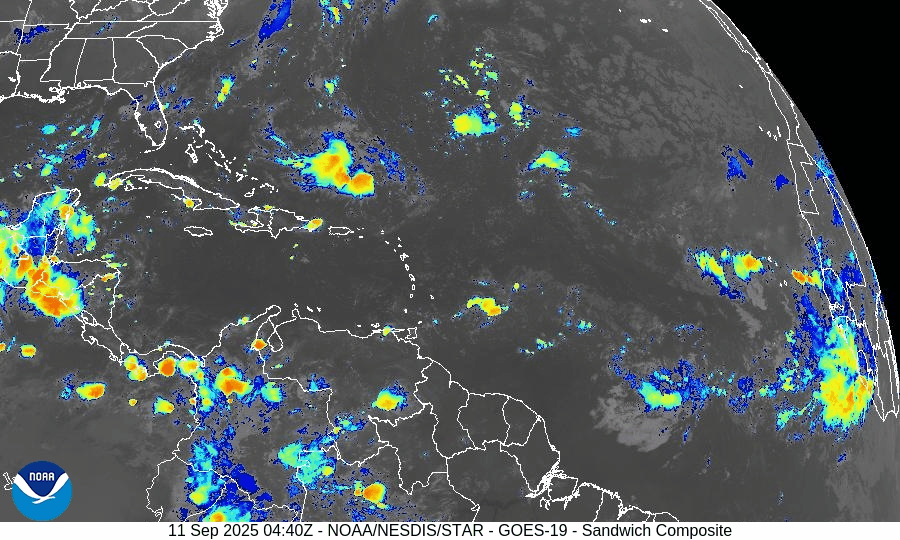
On September 11, the Atlantic basin remains storm-free with no active cyclones. A tropical wave emerging off the coast of Africa has been given a 30% chance of development over the next 7 days, though environmental conditions such as wind shear, dry air, and Saharan dust remain unfavorable. The Gulf of Mexico and Florida stay calm, experiencing only typical late-summer thunderstorms.

Atlantic remains calm; weak tropical wave off Africa flagged with low chance (30%) of development over 7 days
Atlantic Basin Overview
No Active Tropical Cyclones
The Atlantic basin, including the Caribbean Sea and Gulf of Mexico, currently has no active tropical storms, hurricanes, or depressions. The NHC outlook confirms no formation expected in the near term.Tropical Wave Off Africa
A tropical wave is forecast to emerge offshore of West Africa by Friday. It will travel west to west-northwest at about 15 mph, over the eastern and central tropical Atlantic. Although conditions may allow for some gradual development, the NHC gives this wave a low chance (near 0%) over the next 48 hours, increasing to 30% over the next 7 days.
Environmental Conditions
Sea Surface Temperatures (SSTs): Warm in the Gulf and Caribbean (29–31 °C), supportive for storm formation there—but in the eastern tropical Atlantic, SSTs are marginal or just adequate for potential development.
Wind Shear: Moderate to high shear persists across much of the Atlantic, making rapid development unlikely.
Dry Air & Saharan Air Layer (SAL): Dry mid-level air and SAL remain strong headwinds for storm formation, especially for any tropical waves nearing the eastern Atlantic.
Gulf of America (Mexico) & Caribbean
Conditions remain quiet and stable. Only routine afternoon thunderstorms are expected along coastal areas, with no tropical system showing signs of organization.
Florida & Southeast U.S. Forecast
Florida continues in its typical early-September weather pattern—hot, humid, and marked by scattered afternoon thunderstorms. With no active systems in the Atlantic, Gulf, or nearby, there are no coastal or tropical threats expected in the short term. Surf and marine conditions are generally benign.
Rain forecast visualization courtesy of Windy.com

Summary
Atlantic is quiet with no active tropical storms.
Weak tropical wave off Africa has ~30% chance of development in 7 days; 0% in the next 48 hours.
Environmental factors (SSTs, shear, dry air/SAL) remain mostly unfavorable.
Gulf and Florida remain calm with routine summer convection.
TL;DR – September 11 Snapshot
No active storms in the Atlantic.
Wave off Africa has low but nonzero chance (30%) of forming in the coming days.
Hostile environment limits quick growth.
Florida and Gulf: quiet, typical late-summer weather.

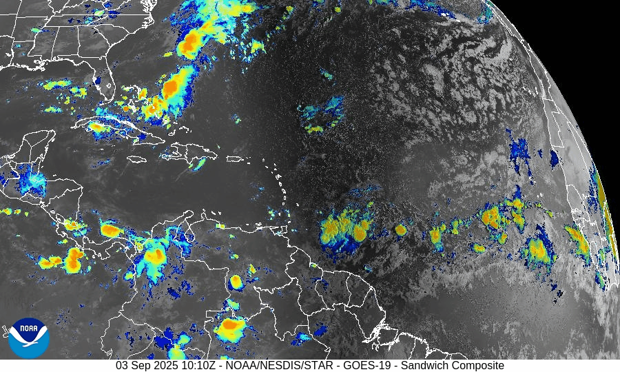
Atlantic Hurricane Outlook – September 3, 2025
On September 3, the Atlantic basin remains free of active tropical cyclones. A tropical wave emerging from Africa is showing increased signs of organization, with the NHC assigning a 70% chance of development over the next week. This system could become Tropical Depression Seven or Tropical Storm Gabrielle. Florida and the Gulf of Mexico remain quiet, experiencing only typical late-summer thunderstorms.

TLDR Version: Click Here
Atlantic remains quiet; African wave now has 70% 7-day development odds
Atlantic Basin Overview
No Active Storms
The Atlantic basin continues to be free of active tropical cyclones—no storms are currently present.Tropical Wave Off Africa
A tropical wave exiting Africa is gaining strength. The NHC now gives this system a 0% development chance in 48 hours, rising to 70% over 7 days. Development into Tropical Depression Seven—and possibly Tropical Storm Gabrielle—is considered likely by the weekend.
Environmental Conditions
Sea Surface Temperatures (SSTs): Remain warm in the Caribbean and Gulf (about 29–31 °C) but cooler farther east, where the African wave is located.
Wind Shear: Moderate to strong shear persists across much of the Atlantic but may ease near the developing wave.
Mid-Level Humidity & SAL: Dry air and the Saharan Air Layer (SAL) are widespread, but are expected to diminish along the wave’s path as it tracks westward.
Gulf of America (Mexico) & Caribbean
The Gulf remains quiet, dominated by high pressure. Only routine afternoon thunderstorms are expected along coastal areas; no tropical development is expected at this time.
Florida & Southeast U.S. Forecast
Florida continues with typical early-September weather: hot and humid, with scattered sea-breeze-driven afternoon thunderstorms. No tropical threats are expected. Coastal waters are calmer as the Atlantic’s longtime surf persists from prior systems but gently subsides.
Rain forecast visualization courtesy of Windy.com

Summary
Atlantic basin remains calm with no systems currently active.
A tropical wave off Africa shows a high (70%) chance of developing into a tropical cyclone within 7 days.
Environmental factors—warm SSTs but competing dry air, SAL, and wind shear—will determine if and when development occurs.
Gulf and Florida remain storm-free and continue typical late-summer weather patterns.
TL;DR – September 3 Snapshot
Atlantic is quiet with no storms.
African wave now has 70% development odds over the next 7 days.
Atlantic environment remains marginal but improving near the wave.
Florida and Gulf remain calm with routine storms.

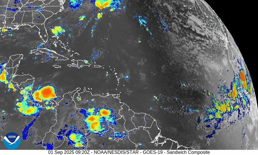
Atlantic Hurricane Outlook – September 2, 2025
On September 2, the Atlantic remains storm-free with no active tropical cyclones. A tropical wave emerging off the coast of Africa shows rising organization and carries a 70% chance of development within 7 days. Environmental conditions are gradually improving, though dry air and Saharan dust remain factors. The Gulf of Mexico and Florida stay calm with only typical early-September thunderstorms.

TLDR Version: Click Here
Atlantic remains quiet; African wave gaining strength with a 70% 7-day development chance
Atlantic Basin Overview
No Active Storms
The Atlantic basin remains clear of any active tropical cyclones.Tropical Wave Emerging off Africa
A tropical wave located south of the Cabo Verde Islands is showing signs of organization. Environmental conditions are becoming more favorable, prompting a forecast of a low 30% chance of formation in the next 48 hours, rising significantly to a high 70% chance of development over the next 7 days.
Environmental Conditions
Sea Surface Temperatures (SSTs): Remain warm (~29–31 °C) in the Caribbean and Gulf, supportive for tropical development. Cooler conditions persist in the open Atlantic.
Wind Shear: Moderate to strong across much of the Atlantic; however, shear is forecast to ease gradually across the eastern tropical Atlantic, aiding organization of the wave.
Mid-Level Humidity & SAL: While dry air and Saharan Dust (SAL) remain present, pockets of increasing moisture near the African wave are aiding its potential development.
Gulf of America (Mexico) & Caribbean
The Gulf remains quiet, dominated by high pressure. Expect only daily sea-breeze afternoon thunderstorms—no tropical development is anticipated.
Florida & Southeast U.S. Forecast
Florida continues with typical early-September weather—hot, humid, and prone to scattered afternoon thunderstorms. There are no tropical threats or coastal hazards affecting the state at this time.
Rain forecast visualization courtesy of Windy.com
Summary

Atlantic basin remains calm, but one African wave shows high development potential (70%) over 7 days.
Environmental factors including SSTs, shear, moisture, and SAL will determine whether it organizes.
Gulf and Florida experience routine late-summer weather; no tropical systems in the near term.
TL;DR – September 2 Snapshot
Atlantic quiet with no storms.
70% chance a wave near Africa develops in the next 7 days.
Warm SSTs but competing shear and dry air—watch environment closely.
Florida and Gulf remain in standard summer pattern.

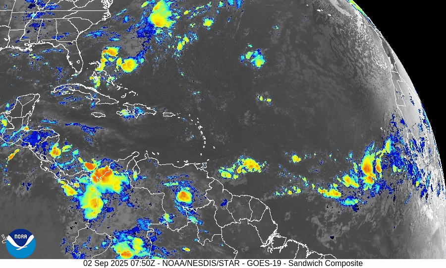
Atlantic Hurricane Outlook – September 1, 2025
On September 1, the Atlantic remains storm-free with no active cyclones. A tropical wave emerging off the coast of Africa carries a 40% chance of development over the next 7 days. While environmental conditions—wind shear, dry air, and Saharan dust—are suppressing rapid growth, the wave will be monitored closely. Florida and the Gulf of Mexico remain quiet, experiencing only typical early-September thunderstorms.

TLDR Version: Click Here
Atlantic remains quiet; tropical wave off Africa shows rising potential (40% over 7 days)
Atlantic Basin Overview
No Active Storms
There are currently no active tropical cyclones in the Atlantic basin—the first tranquil period we've seen since the wake of Fernand and Erin.Emerging Tropical Wave Off Africa
A new tropical wave has emerged off the West Coast of Africa near Guinea-Bissau. Presently disorganized, the NHC assigns it a 0% chance of development in the next 48 hours, but the probability rises to about 40% over the next 7 days. This system will be closely monitored as it moves west across the tropical Atlantic.
Environmental Conditions
Sea Surface Temperatures (SSTs): Remain warm in the Gulf and Caribbean (29–31 °C), while the open Atlantic heat content diminishes northward.
Wind Shear: Elevated shear across much of the basin continues to suppress storm formation.
Mid-Level Humidity & SAL (Saharan Air Layer): Dry air and SAL dust are widespread, inhibiting significant convection and limiting the strength of the new wave emerging off Africa.
Gulf of America & Caribbean
The Gulf remains stable and quiet, under the influence of high pressure. Only routine afternoon sea-breeze thunderstorms are expected—no tropical threats are present.
Florida & Southeast U.S. Forecast
Florida continues in its trademark late-August/early-September pattern: hot, humid, with scattered afternoon thunderstorms. With no active systems nearby, no coastal or tropical threats are expected this week.
Rain forecast visualization courtesy of Windy.com
Summary

No storms are currently active in the Atlantic basin.
A tropical wave off Africa is being monitored, with a 40% chance of developing within 7 days.
Environmental factors—including cool SSTs, strong shear, dry air, and SAL—are suppressing tropical development.
Gulf and Florida remain quiet, with only standard summertime weather patterns in play.
TL;DR – September 1 Snapshot
Atlantic is fully quiet; no active storms.
Tropical wave off Africa now has 40% 7-day development odds.
Hostile conditions in place, limiting immediate storm formation.
Florida and Gulf remain calm, aside from typical daily thunderstorms.
