

Atlantic Hurricane Outlook – July 30, 2025: Development Chances Remain Low
As July ends, the Atlantic Basin sees active tropical waves, but development chances remain low for the next 7 days. Discover the latest on sea surface temperatures, wind shear, Saharan Air Layer, and the outlook from CAT5Prep.com.
*Those who like data, continue reading. Those it prefer the quick version, jump to the TL;DR here.
** Due to technical issues on the GOES satellite imagery provider's end, we are currently unable to display real-time satellite imagery.
The Atlantic Basin remains active with multiple tropical waves stretching from the African coast to the Caribbean, yet no organized development is expected in the near term. Wind shear and Saharan dust continue to suppress cyclone formation despite warm ocean temperatures and a moistening atmosphere in the western basin.
As we close out July, conditions are slowly trending toward a more favorable setup for storm development heading into August.
Atlantic Basin Overview
As of the 8:00 AM EDT NHC Tropical Weather Outlook:
No active tropical cyclones.
Three tropical waves span the Atlantic:
Wave near 35°W (eastern Atlantic): Disorganized, little convection.
Wave near 50°W (central Atlantic): Producing scattered thunderstorms, no surface low.
Wave in the eastern Caribbean: Weak and encountering dry air and shear.
NHC Development Odds:
Next 48 hours: 0%
Next 7 days: 0%
Key Environmental Factors
SST data courtesy of Windy.com
Wind data at 850hPa from Windy.com
Sea Surface Temperatures (SSTs):
29–31°C (84–88°F) in the Gulf of Mexico and Caribbean.
MDR remains slightly warmer than normal.
Wind Shear:
Moderate across the central Atlantic and Caribbean.
Suppressing vertical development for now.
Saharan Air Layer (SAL):
Strong dry air across much of the basin.
Limiting convection and keeping tropical waves disorganized.
Moisture:
Gradually increasing in the western Atlantic and Caribbean.
A factor to monitor as wind shear begins to ease.
Gulf of Mexico (Gulf of America)
A weak surface trough in the central Gulf is producing scattered showers and isolated thunderstorms.
No signs of organization, and the NHC does not expect development at this time.
High pressure remains dominant elsewhere, with calm conditions expected through midweek.
Florida Weather
Highs in the upper 80s to low 90s with high humidity.
Scattered thunderstorms possible in the afternoon and evening from sea breeze interactions.
No tropical threats to Florida at this time.
Radar imagery courtesy of Windy.com
Outlook & Preparedness
The Atlantic remains broadly quiet for now, but the environment is slowly shifting. A steady wave train emerging off Africa and increasingly favorable SSTs point to a more active window in early to mid-August.
Now is the time to double-check hurricane kits, review evacuation zones, and prepare while the weather allows.
TL;DR – July 30 Snapshot
No tropical development expected this week.
Three tropical waves are present but remain weak and disorganized.
SAL and shear are limiting development.
Conditions should become more favorable by early August.
Atlantic Hurricane Outlook – July 19, 2025: Disturbance in the Deep Tropics Eyes Development
A tropical wave southwest of the Cabo Verde Islands shows a low chance of development as it moves westward. Conditions remain mixed across the Atlantic, but signs of activity are increasing.
The Atlantic Basin remains relatively quiet today, but there’s a new player on the map. A tropical wave in the central tropical Atlantic—labeled Disturbance 1—has a low but notable chance of development over the next week. This marks the first sign of deeper tropical activity emerging from the Main Development Region (MDR) as we move closer to peak hurricane season.
Atlantic Basin Overview: One Area to Watch
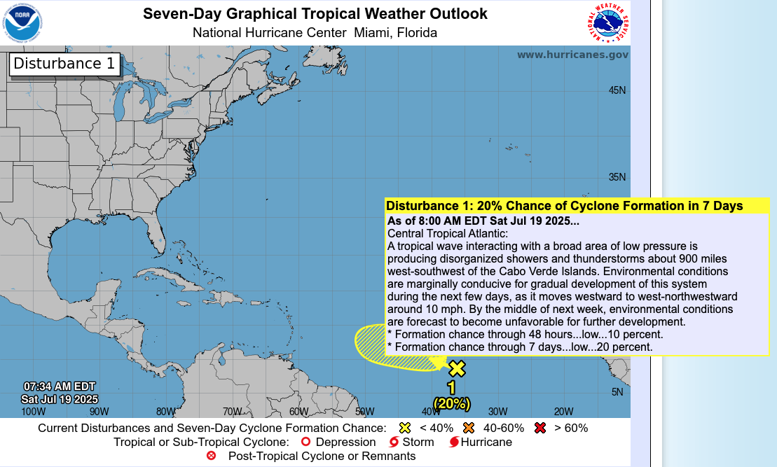
As of 8:00 AM EDT Saturday, July 19, 2025, the National Hurricane Center is monitoring:
No named tropical cyclones
One disturbance in the central Atlantic
Tropical development chances:
10% over 48 hours
20% over 7 days
Disturbance 1 is a tropical wave located about 900 miles west-southwest of the Cabo Verde Islands, interacting with a broad area of low pressure. Showers and thunderstorms remain disorganized, but marginally favorable conditions could support slow development as the system moves west to west-northwest around 10 mph.
However, by mid-week, environmental conditions are expected to become less favorable, limiting its window for intensification.
Satellite imagery courtesy of Windy.com
Sea Surface Temperatures: Fuel in Place
Waters remain very warm across much of the Atlantic:
Gulf of Mexico: Holding above 86°F (30°C) in many areas
Western Caribbean: High SSTs remain steady
Main Development Region (MDR): Warm enough to support tropical wave development—an important factor as more systems emerge off Africa
These warm waters are key to supporting systems like Disturbance 1.
Sea Surface Temperature data courtesy of Windy.com
Wind Shear & Moisture: Still Mixed
Wind Shear: Moderate in the eastern Atlantic near Disturbance 1 but lower closer to the Caribbean
Moisture: Rising across the western Atlantic, but dry air from the Saharan Air Layer (SAL) is still suppressing deeper convection across much of the MDR
While the disturbance has some support for development, these mixed upper-atmospheric conditions could limit growth.

Wind Shear Courtesy of https://tropic.ssec.wisc.edu/
Relative Humidity (ECMWF) data courtesy of Windy.com
Saharan Air Layer: Still an Inhibitor
Dry, dusty air continues to stretch across much of the central and eastern Atlantic. It:
Reduces storm cloud organization
Increases atmospheric stability
Weakens convection associated with tropical waves
SAL is expected to persist into early August but may begin to recede gradually.
Saharan Air Layer (Dust) data courtesy of Windy.com
Thunderstorm Activity: Isolated and Mostly Local
Florida: Scattered PM thunderstorms expected—typical for this time of year
Gulf & Western Caribbean: Moisture lingers but no signs of tropical organization
Off Africa/Central Atlantic: Activity is tied to Disturbance 1, but convection remains weak
Thunderstorm forecast (ECMWF) courtesy of Windy.com
Florida Forecast
Highs: Upper 80s to low 90s
Humidity: High
Rain: Isolated to scattered afternoon storms
Winds: Light to moderate easterlies
Rainfall forecast (ECMWF) courtesy of Windy.com
Prep Tip of the Day: Know the Early Signs
With deeper Atlantic activity beginning, now is a good time to refresh your awareness:
Follow NHC's five-day outlooks
Understand what “low chance” really means—it can change fast with heat and time
Review your emergency communication plan and make sure alerts are enabled
Looking Ahead: Watch the MDR
While Disturbance 1 may or may not develop, its emergence from the Cabo Verde region is a signal that the deep tropics are beginning to stir. Expect more waves in the coming weeks as we approach the climatological ramp-up of hurricane season.
Stay informed. Stay ready. Your next real-time update comes tomorrow from Cat5Prep.