Atlantic Hurricane Outlook – September 16, 2025
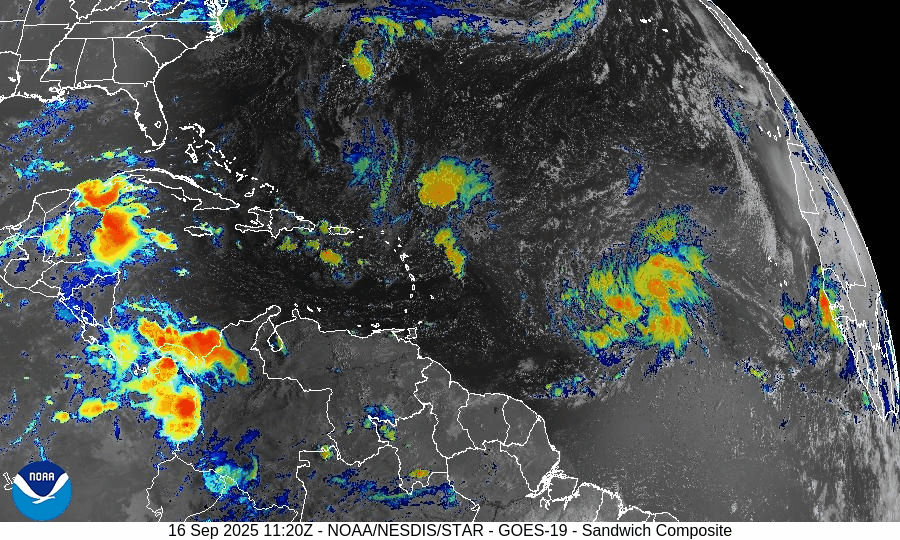
On September 16, Invest 92L in the central Atlantic continues to organize and has a 90% chance of becoming a tropical depression or Tropical Storm Gabrielle in the next 48 hours. Another tropical wave is emerging off Africa with a lower 20% chance of development over 7 days. While warm waters and reduced wind shear support 92L’s growth, dry air and Saharan dust continue to hinder the African wave. Florida and the Gulf remain calm with only typical late-summer storms.

Invest 92L likely to become Tropical Storm Gabrielle; new wave off Africa also being monitored
Atlantic Basin Overview
Invest 92L
A broad area of low pressure known as Invest 92L—located about midway between the Windward Islands and the coast of West Africa—is showing increasing organization. The National Hurricane Center indicates high odds (≈ 90%) of formation into a tropical depression or tropical storm within the next 48 hours and similarly high odds over a 7-day outlook. Forecasts suggest it will move west-northwest or northwest at 10-15 mph. If named, it will be called Gabrielle.New Tropical Wave Off Africa
Another tropical wave is emerging off the western coast of Africa. It has lower odds of development—roughly 20% over 7 days, and near zero in the next 48 hours. It is moving westward toward the central Atlantic, where conditions could improve for gradual organization.
Environmental Conditions
Sea Surface Temperatures (SSTs): SSTs remain warm in the central to western tropical Atlantic, supportive of tropical storm development for disturbances like Invest 92L.
Wind Shear: The upper-level wind shear is decreasing in regions around Invest 92L, aiding its organization. However, moderate shear still exists in other parts of the basin, especially for newer waves emerging off Africa.
Dry Air & Saharan Air Layer (SAL): Dry air and dust from the Saharan Air Layer remain present in parts of the eastern Atlantic, which is damping convection in the newer wave. For Invest 92L, moisture levels are improving, helping its organizational efforts.
Gulf of America (Mexico) & Caribbean
The Gulf of Mexico and Caribbean remain mostly quiet. High pressure dominates, and while afternoon thunderstorms remain routine, no tropical development is expected in these regions in the near term.
Florida & Southeast U.S. Forecast
Florida is under its normal mid-September weather pattern—hot, humid, with scattered afternoon storms. There is no immediate tropical threat to Florida from Invest 92L or the wave off Africa at this time, though residents should monitor forecasts in case the track changes.
Rain forecast visualization courtesy of Windy.com

Summary
Invest 92L is very likely to become Tropical Storm Gabrielle imminently, with high chances over the next 1-2 days.
A new wave off Africa has low development odds now but could gain strength later in the week.
Environmental factors (warm SSTs, easing shear, improving moisture) favor development of Invest 92L, though SAL and dry air still affect newer disturbances.
Gulf, Caribbean, and Florida remain calm with only routine summer weather expected.
TL;DR – September 16 Snapshot
Invest 92L expected to form soon (likely Tropical Storm Gabrielle) with ~90% odds.
New wave off Africa has modest (~20%) 7-day potential.
Conditions are increasingly favorable around Invest 92L.
No tropical threats to Florida or the U.S. currently; routine summer storms only.